Showing 126301 items
matching main-road
-
 Mt Dandenong & District Historical Society Inc.
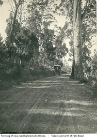
Photograph, Forming Of New Road Kalorama To Olinda, early 1920s
The new Main Road, now Mt Dandenong Tourist Road, was completed in 1926. This scene is looking towards Montrose down from the intesection of Falls Road.Scene of wagon drawn by two horses on wide dirt road with large trees on side of road. Taken just north of Falls Road.wagon, road, main road, mt dandenong tourist road, falls road, horse -
 Eltham District Historical Society Inc
Photograph, Jim Connor, Main Road, Eltham, 14 Jan 2017
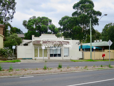
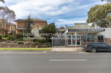
Eltham Gateway, Sweet D Lites, 820 Main Road, Eltham. Former Burgoyne shop and Post Office, now home to San Antonio Barbershop. Once affectionately known as the Hilltop milk bar, or Burgoyne’s, this is one of the only three remaining early twentieth century village shops in Eltham and as the community’s first post office. In the 1920’s, the post office was run from a tiny 6 by 6 corrugated iron shed at the side of the store. Miss Hunniford, the post mistress, would give you your mail or take your letters to send, as there was no postal delivery service at that time. In an emergency, such as illness, you could send a telegraph for tuppence (around two cents) a word. Later, this was the site of the Eltham’s first telephone exchange. Tomorrow's history documented todayeltham, jim connor collection, main road, eltham gateway, burgoyne's shop, sweeet d lites, hilltop milk bar -
 Eltham District Historical Society Inc
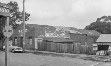
Photograph, Eltham Produce Store, Main Road, c.1960
Operated by John McLean and Son Situated just south from opposite Arthur Street, opposite the Eltham Village Shopping Centre. In 1974 the site was the location of the B.P Garage and opposite was the Woolworths Arcade. The Produce Store sold hay and grain. To the right was Garnet Burges' second hand scrap metal and bottles, then the blacksmith shop, which was later taken over by Garnet with second hand furniture and next door to that was Ray Staff's grocery store. The brick building has signage to promote Tanox Paint and Permoglaze products. This building was demolished by 1963 for the BP Evergreen Service Station. Photo taken at same time as Shire of Eltham Pioneers Photograph Collection No. 785 which is a view from near Arthur Street and Main Road intersection.Colour photograph copy of original photoshops, main road, eltham, eltham produce store, tanox paint, permaglaze, produce station, john mclean and son, garnet burges -
 Greensborough Historical Society
Photograph - Digital Image, R. Max Neumann, Greensborough Anglican Church and Main Street shops 1966, 1966_02
Greensborough Anglican Church and Main Street shops [February 1966]An example of the changing streetscape in GreensboroughDigital copy of colour photographall saints anglican church greensborough, main street greensborough -
 Greensborough Historical Society
Photograph - Digital image, Marilyn Smith, 78 Main Street Construction - Rear View, 18/01/2016
Development on Main Street Greensborough (rear view), January 2016. Shows the changing streetscape of Main Street.Digital copy of colour photographmain street greensborough -
 Tarnagulla History Archive
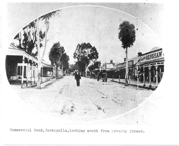
Photograph of Commercial Road, Tarnagulla looking south from Poverty Street, Commercial Road, Tarnagulla Looking South from Poverty Street, January 1907, at the time of the Poseidon Gold Rush, circa 1890 - 1900
Murray Comrie Collection. This is a reasonable copy of an older original. Copy probably made by Murray Comrie in the 1970s. Monochrome photograph. View of Commercial Road Tarnagulla looking south. A man at centre, walking toward camera. Right of this figure are two carts standing at the road's edge. Far right is Renshaw's Drapery and left of that the Golden Age Hotel. A man is walking along the footpath in front of Renshaw's. Typed caption on original is 'Commercial Road, Tarnagulla, looking south from Poverty Street'.tarnagulla, commerce, stores, shopping, shops, draper, hotels, golden age hotel, buildings, commercial road, main street -
 Stawell Historical Society Inc
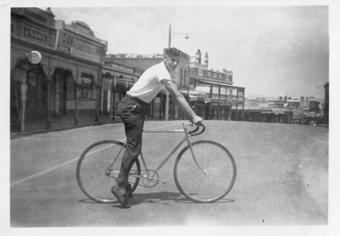
Photograph, Mr Alan Tangey on a Bicycle in Upper Main Street 1947
Christmas 1947 Upper Main Street with Bull and Mouth Hotel Alan Tangey parallel parked across Main Street wearing short sleeved shirt, dark trousers, socks and bicycle shoes. Upper Main Street and Bull and Mouth Hotel in Background.Christmas 47" 441 Veloxhotel, sport -
 Eltham District Historical Society Inc
Slide, Main Road, Eltham, c. Jun 1981
Roll of film taken by Eltham Shire Council officers specifically focussed on road infrastructure and maintenance. Many roads of the shire were only relatively recently sealed towards the late 1980s/early 1990s.35 mm colour positive transparency (1 of 8) Mount - Kodak Kodachrome CardProcessed July 1981infrastructure, roads, main road, eltham, footpaths and gutters -
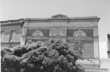 Stawell Historical Society Inc
Photograph, Mechanics Institute in Main Street Street Stawell 1992 -- Coloured
Mechanics Institute Main Street Stawell. Used for many years as the library. Two coloured photos 1992.Five photographs of Mechanics institute Upper Main Streetstawell -
 Eltham District Historical Society Inc
Photograph, Russell Yeoman, Intersection of Fitzsimons Lane with Main Road, Eltham, c.1969, 1969c
Shows intersection of Old Eltham RoadDigital file only; created from original colour positive slide transparencystreets, eltham, main road, fitzsimons lane, old eltham road -
 Eltham District Historical Society Inc
Photograph, Peter Pidgeon, 820 Main Road, Eltham, 2 Aug. 2022
In 1855 the first post office opened in Eltham under the management of Thomas Hunniford. It was a weatherboard building located on the eastern side of Main Road just south of Bridge Street. During the 1880s under the managment of Hunniford's daughter, Anne, the building was modernised with a new awning and upper facade. In late 1925 a new brick building was erected immediately next door (820 Main Road). Following the death of Anne Hunniford in December 1928, J.N Burgoyne was appointed Postmaster. The extension to the right of the store was erected in 1939 for a new telephone exchange adjacent to the store and post office. A continuous telephone service operated by Mr Burgoyne and his family commenced operation 18 November 1939. Approximately 70 extensions were routed through the new exchange, 40 of which were transferred from the Greensborough Exchange. Entry to the exchange was via a separate door on Main Road or via the shop. The public telephone was initially mounted on the wall but later moved to the street. The present store is a barber shop and it remains, though heavily modified, one of only three remaining shop fronts from the early 1900s in Eltham. Comparison photo: SEPP_0700, 00140, SEPP_0701, SEPP_0702 Part of a presentation by Peter Pidgeon to the Society, 13 August 2022 showcasing a series of photographs taken by John Henry Clark over the period 1895 to 1930. John Henry Clark was the youngest of three boys born to William Henry Clark (1823-1877) and Maria White (1843-1914). He and his brothers, William Charles Clark (1872-1945), Clement Kent Clark (1874-1912) operated a photography business (Clark Bros.) from 25 Thomas Street, Windsor near Prahran during the period c.1894 to 1914. Following death of Clement in September 1912 and their mother in 1914, the Clark Bros business appears to have dissolved, the premises demolished, and a new house was under construction in 1915. John set up business independently in 1914 operating out of 29 Moor Street, Fitzroy where he is registered in the 1914 and 1915 Electoral Rolls. By 1916 John had relocated to Eltham where he continued his practice as a photographer and took many of the early images around the district of Little Eltham. Around 1930 John changed professions and opened a small cobbler's shop in 1931 near the pond opposite Dalton Street adjacent to the Jarrold family cottage. He never married and continued his profession as a bootmaker from this little shop, maintaining a close relationship with Mrs Jarrold for the rest of their lives. His bootmaker shop remains today beside the Whitecloud cottage and is one of only three remaining shops in the area from the early 20th century.Comparative photo taken 2022 with one taken from same location over 100 years earlier by noted local photographer J.H. ClarkBorn Digitaleltham, j.h. clark photo (2022), main road, 820 main road, burgoyne store -
 Melbourne Tram Museum
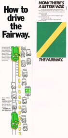
Pamphlet - How to drive the Fairway, VicRoads, "Now there's a better way"
Provides the basis for segregating road traffic from tram lines at intersections and along roadways and road markings applied.Yields information about the introduction of Fairways into Melbourne tramway streets during 1983, the first legal segregation of trams from road traffic.Set of two pamphlets regarding Tram Fairways. .1 - Three-section vertical fold-out pamphlet titled "How to drive the Fairway" printed on gloss paper showing the fairway system and how its works with the various signs in a cartoon manner. Notes the Fairway system was set up in 1983 and the basis of it. Has the VicRoads logos, name, and "Victoria Growing together? logos. .2 - Three-section, horizontal format pamphlet on plain paper, titled "Now there's a better way", giving details of the system, showing drawings and how they work at intersections. Issued by the Road Traffic Authority, has the RTA logo. .3 - Newspaper cutting, titled "The old way, the Fairway" giving advanced notice of the introduction of the Fairway system and the roads impacted. Has an AEC election advertisement on the rear for the March 1983 Federal Election.fairways, cartoons, rta, vicroads, traffic control, trams, tramways -
 Stawell Historical Society Inc
Map, R.O. Robson - Authorised Surveyor, Road from Glenorchy to near Geary's Selection Callawaddy 1880, 29.04.1880
Survey for Road CreationCloth Backed Map. Plan of Road.Parishes of Richella & Callawadda. County of Borong. Plan of Road. R.O. Robson Authorised Surveyor Stawell 29.04.80 -
 Ballarat Tramway Museum
Photograph - Ballarat tram no.35 at cnr of Barkley & Main Sts. Also see 5293, Ballarat tram no.35 at cnr of Barkley & Main Sts
Ballarat tram no. 35 on the Mt Pleasant line, seen turning from Barkly St into Main St, returning to the City.Provides information on how people travelled and from the Mt pleasant district in particular.Ballarat tram no.35 at cnr of Barkley & Main Sts"No 35", "91", "KEN MAGOR" Neg. No 1901"ballarat, ballarat tramways, no. 35 -
 Eltham District Historical Society Inc
Photograph - Digital Photograph, Marguerite Marshall, Wingrove Cottage, Main Road, Eltham, 8 June 2006
Wingrove Cottage built 1858-1859 of hand made bricks is historically significant for its long association with Charles Wingrove, a prominent figure in Victorian local government, as secretary to the Eltham District Road Board and Shire Council from 1858 to 1904, and Shire Engineer and Secretary to the Heidelberg Road Board. The cottage was used as the office of the Eltham District Road Board and Council for many years It is one of the Shire's oldest dwellings, and one of the few surviving 19th century buildings associated with early Eltham and located in the original Eltham Village Reserve. The symmetrical planting of a pair of Pencil Pines (not visible in photo) is also historically and aesthetically significant as characteristic of the early period of planting in the district and because they are a distinctive landscape feature. In October 2002 new owners demolished the outbuildings attached to the rear of the cottage. Community protest at the demolition resulted in Council issuing a Stop Work order. The owner was issued with a court order in September 2003 to develop a conservation management plan and restore the heritage listed property. The owner sold the property in 2005 to Cameron Construction in 2005 who undertook the restoration work. In 2007 a planning application to build two offices and seven dwellings at the rear of the property was ultimately rejected. The cottage is now the main office for Cameron Construction. Covered under Heritage Overlay, Nillumbik Planning Scheme. Published: Nillumbik Now and Then / Marguerite Marshall 2008; photographs Alan King with Marguerite Marshall.; p57 Wingrove Cottage on Main Road beside Eltham Primary School, is one of the Shire’s most important historical buildings and was central to local government for almost 50 years. The cottage was built in stages from 1858 to 1888 for Charles Symons Wingrove JP. He was the Eltham District Road Board’s first paid secretary and later the Shire Secretary when the board became the Eltham Shire Council. Wingrove held those positions, and that of engineer for a time, for 46 years. He was also one of the main figures in the Municipal Association of Victoria. As Eltham’s first paid municipal officer, Wingrove used one room in his 11 – (originally two) roomed home, as the office for the board then the council. Meetings were held there from the late 1850s (as well as at more central locations) until Wingrove’s retirement in 1904. The cottage is a rare example of a local government office occupying a Road Board /Shire Secretary’s purpose-designed house. The cottage is also significant because it is the oldest largely intact building from the original Eltham township reserve (south of Dalton Street).1 The township had its origins in the 1848 Nillumbik Parish Plan and was one of the state’s earliest township reserves. The rectangular house of handmade bricks, roofed with grey slate tiles and with a veranda encompassing three sides, is reminiscent of those in the central goldfields including Castlemaine. Its overhanging eaves and gables were unlike houses in Melbourne at the time. Wingrove, who was born in 1827, had been a gold digger and a road surveyor. Impossible to imagine in today’s world, Wingrove was also the Shire of Heidelberg’s secretary and engineer for part of the time that he was secretary in Eltham. Living next door to the primary school was a mixed blessing. Wingrove and his wife Katherine, who had ten children, sent their eight surviving children to the school. But they had occasional disputes with the school authorities when their cattle wandered into the schoolyard. Eltham showed Charles Wingrove its appreciation of his services by giving him two illuminated addresses, one after ten years and the other at retirement. Wingrove died in 1905 aged 76 and was buried in the St Katherine’s Church of England cemetery in St Helena. His grave is surrounded by those of family members including his wife, Katherine and two babies, Henry, 12 months and Isobella, 15 months, who died in the mid-1860s. Cottage ownership passed to his wife, then to daughter Caroline and then to daughter Bessie, a Melbourne University graduate and artist. During the Great Depression their brother Walter was the ratepayer. At one stage the Wingrove property extended to Metery Road and included a small creek. The family ran a small dairy and orchard, with associated farm buildings, which were later removed. In 1949 part of the property was compulsorily acquired by the Eltham Primary School, which infuriated owner Bessie Wingrove. She protested in a letter about this ‘monstrous act of unmitigated tyranny’.2 She was the last Wingrove to occupy the cottage and died in 1955. Wingrove descendants sold the house in 1974 and the property was subdivided. In the 1960s the Eltham Shire named the park opposite the cottage in Wingrove’s honour. The cottage has since had several owners including psychiatrist Dr Daniel Kahans, who practised there. In October 2002 late rear additions which had been substantially altered were demolished contrary to council planning controls. This caused a community outcry and resulted in legal proceedings against the owner. Fortunately the historical significance of the demolished section was not as great as the older front part of the building, which has been retained and was later restored.This collection of almost 130 photos about places and people within the Shire of Nillumbik, an urban and rural municipality in Melbourne's north, contributes to an understanding of the history of the Shire. Published in 2008 immediately prior to the Black Saturday bushfires of February 7, 2009, it documents sites that were impacted, and in some cases destroyed by the fires. It includes photographs taken especially for the publication, creating a unique time capsule representing the Shire in the early 21st century. It remains the most recent comprehenesive publication devoted to the Shire's history connecting local residents to the past. nillumbik now and then (marshall-king) collection, cameron construction, charles symons wingrove, eltham, eltham road district board, eltham shire council, main road, wingrove cottage -
 Eltham District Historical Society Inc
Negative - Photograph, J.H. Clark, Jarrold family and cottage, Main Road, Eltham, 1911
Jarrold family and cottage, Main Road, Eltham Members of the Jarrold family and others outside their home in Maria Street (Main Road), Eltham at the bottom of Policeman’s Hill, opposite Dalton Street. The small youth in centre foreground is believed to be George Coleman (see SEPP_0745). John Jarrold (1865-1909) was a local builder and contractor and widely respected resident. Youth in centre is believed to be George Coleman (1906-1953) (See SEPP_0745). Jarrold Cottage built in 1863, also known as 'White Cloud", located at 701 Main Road, Eltham, opposite Dalton Street. The house remains intact and is listed on the Victorian Heritage Database and considered historically significant to the Shire of Nillumbik. The cottage was originally located closer to the Diamond Creek but was subject to flooding. It was dragged by horse to the present site shown, which was chosen for the higher ground that had been created as a result of land fill being deposited here from the quarry further around the bend on Main Road (site of present-day Eltham Primary School carpark) where the stone had been quarried for building the State School in Dalton Street. It had previously been rented for use as a Police Station / residence prior to the building of the permanent police house and station at the corner of Maria and Brougham streets in 1859. At the time of collection of photos for the centenary of the Shire of Eltham (1971) the cottage was owned by the Skipper family and remains in the family to present day (2021). Photo dated as 1911 (by donor?). Photo SEPP_0745 was dated 1905 (by donor?) but is estimated to be c.1909. It is also noted it is thought Jack Coleman is in both photos though it is more likely to be his younger brother George who appears about 5 in this photo and 3 in 745. Cross Reference SEPP_0745 / 748 Photographer: J.H. Clark John Henry Clark was the youngest of three boys born to William Henry Clark (1823-1877) and Maria White (1843-1914). He and his brothers, William Charles Clark (1872-1945), Clement Kent Clark (1874-1912) operated a photography business (Clark Bros.) from 25 Thomas Street, Windsor near Prahran during the period c.1894 to 1914. Following death of Clement in September 1912 and their mother in 1914, the Clark Bros business appears to have dissolved, the premises demolished, and a new house was under construction in 1915. John set up business independently in 1914 operating out of 29 Moor Street, Fitzroy where he is registered in the 1914 and 1915 Electoral Rolls. By 1916 John had relocated to Eltham where he continued his practice as a photographer and took many of the early images around the district of Little Eltham. Around 1930 John changed professions and opened a small cobbler's shop in 1931 near the pond opposite Dalton Street adjacent to the Jarrold family cottage. He never married and continued his profession as a bootmaker from this little shop, maintaining a close relationship with Mrs Jarrold for the rest of their lives. His bootmaker shop remains today beside the Whitecloud cottage and is one of only three remaining shops in the area from the early 20th century. There are a couple of images of Eltham taken by Clark Bros. in the Eltham District Historical Society collection, one such example being Hunniford’s Post Office with Miss Anne Hunniford out front (EDHS_00140 - marked on the back of the print, Clark Bros., 25 Thomas St. Windsor), which would date this image between c.1894 and 1914. Other early images of Eltham taken by John Henry Clark are marked on the face “J. H. Clark Photo” and it is assumed these are dated between 1914 and 1930. It is noted that the Grant of Probate for John H Clark of Eltham South dated 5 April !957 (513/387) records his occupation as "X Photographer".This photo forms part of a collection of photographs gathered by the Shire of Eltham for their centenary project book, "Pioneers and Painters: 100 years of the Shire of Eltham" by Alan Marshall (1971). The collection of over 500 images is held in partnership between Eltham District Historical Society and Yarra Plenty Regional Library (Eltham Library) and is now formally known as 'The Shire of Eltham Pioneers Photograph Collection.' It is significant in being the first community sourced collection representing the places and people of the Shire's first one hundred years.Digital image 4 x 5 inch B&W Negshire of eltham pioneers photograph collection, dalton street, eltham, george coleman, j.h. clark photo, jarrold cottage, jarrold family, main road, maria street, white cloud cottage -
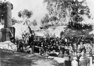
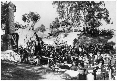 Eltham District Historical Society Inc
Negative - Photograph, Unveiling of War Memorial Obelisk, corner of Main Road and Bridge Street, Eltham, 3 Aug. 1919
The unveiling of the Eltham Obelisk War Memorial was performed by the Rev. Padre Charles Tregear, assisted by Church of England vicar, Mr Safsford on August 3, 1919. Reproduced page 99 of "Pioneers & Painters." "Beneath a lonely pine tree on the hill crest out from Eltham, where the Greensborough Road junctions with the main Melbourne Road, Eltham has erected an everlasting tribute to the memory of the fallen heroes of the district. It is an obelisk of Harcourt granite in the rough, bearing an appropriate inscription and 27 names—an unpretentious monument by the wayside, which will stand for all time silently expressing the appreciation of the living for the sacrifice of the dead. The obelisk stands 14 feet high. ... Representatives of every house in the town, and many people from the surrounding district, gathered around the obelisk for the opening ceremony. The spring-like sunshine of the afternoon attracted everybody out of doors. There must have been 700 people present when the Lieutenant-Governor, Sir William Irvine, removed the draping of flags and revealed the names on the obelisk, the base of which was surrounded by wreaths and branches of wattle bloom, placed there by parents whose sorrow at the loss of sons was blunted, for the day at least, by feelings of pride. .." Age, Monday 4 August 1919, page 8 This was the memorial's orginal location. It has been relocated numerous times.This photo forms part of a collection of photographs gathered by the Shire of Eltham for their centenary project book,"Pioneers and Painters: 100 years of the Shire of Eltham" by Alan Marshall (1971). The collection of over 500 images is held in partnership between Eltham District Historical Society and Yarra Plenty Regional Library (Eltham Library) and is now formally known as the 'The Shire of Eltham Pioneers Photograph Collection.' It is significant in being the first community sourced collection representing the places and people of the Shire's first one hundred years.Digital image 4 x 5 inch B&W Negsepp, shire of eltham pioneers photograph collection, eltham, main road, bridge street, eltham war memorial, obelisk, obelisk corner -
 Eltham District Historical Society Inc
Negative - Photograph, Unveiling of War Memorial Obelisk, corner of Main Road and Bridge Street, Eltham, 3 Aug. 1919
The unveiling of the Eltham Obelisk War Memorial was performed by the Rev. Padre Charles Tregear, assisted by Church of England vicar, Mr Safsford on August 3, 1919. Reproduced page 99 of "Pioneers & Painters." "Beneath a lonely pine tree on the hill crest out from Eltham, where the Greensborough Road junctions with the main Melbourne Road, Eltham has erected an everlasting tribute to the memory of the fallen heroes of the district. It is an obelisk of Harcourt granite in the rough, bearing an appropriate inscription and 27 names—an unpretentious monument by the wayside, which will stand for all time silently expressing the appreciation of the living for the sacrifice of the dead. The obelisk stands 14 feet high. ... Representatives of every house in the town, and many people from the surrounding district, gathered around the obelisk for the opening ceremony. The spring-like sunshine of the afternoon attracted everybody out of doors. There must have been 700 people present when the Lieutenant-Governor, Sir William Irvine, removed the draping of flags and revealed the names on the obelisk, the base of which was surrounded by wreaths and branches of wattle bloom, placed there by parents whose sorrow at the loss of sons was blunted, for the day at least, by feelings of pride. .." Age, Monday 4 August 1919, page 8 This was the memorial's orginal location. It has been relocated numerous times.This photo forms part of a collection of photographs gathered by the Shire of Eltham for their centenary project book,"Pioneers and Painters: 100 years of the Shire of Eltham" by Alan Marshall (1971). The collection of over 500 images is held in partnership between Eltham District Historical Society and Yarra Plenty Regional Library (Eltham Library) and is now formally known as the 'The Shire of Eltham Pioneers Photograph Collection.' It is significant in being the first community sourced collection representing the places and people of the Shire's first one hundred years.Digital image 4 x 5 inch B&W Neg Print 9 x 12.5cmsepp, shire of eltham pioneers photograph collection, eltham, main road, eltham war memorial, bridge street, obelisk, obelisk corner -
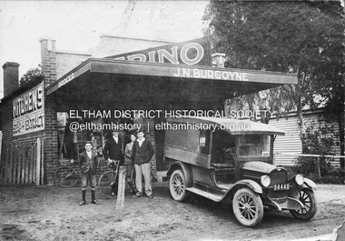 Eltham District Historical Society Inc
Negative - Photograph, J.N. Burgoyne’s store, Main Road, Eltham, Vic, c.1930
The photo is of John Neville and Ethel (Polly) Burgoyne’s store with eldest children and a 1927/28 model Chevrolet 1 ton truck. The store was located on Main Road just south of Bridge Street (present day No. 820 Main Road). L-R (unconfirmed): Francis (Frank) Neville Burgoyne (1916-2002), unidentified, Mary Frances Burgoyne (1914-1991) and John (Jack) William Burgoyne (1913-2005) which would date the picture as circa 1929/1930. Henry Charles Burgoyne (1920-1994) and Royston (Roy) Edward Burgoyne (1922-2004) not in picture. The unidentified male is believed to be an early boyfriend of Mary Frances at the time, not Reginald John Squire (1916-1981) whom she married in 1938 who was two years her junior. The new store was built in late 1925. At the same time Mr C. Nicholls’s new store was constructed. Both were considered modern shops, and an improvement on most, business establishments of the time. Mr. Nicholls’s store included alongside it a modern, weatherboard villa residence. Mr. Burgoyne’s store incorporated the post and telegraph office, which was operated by John Neville Burgoyne’s half-aunt, Miss Anne Hunniford. The unsealed footpath in front is reasonably extensive as not visible is a concrete kerb and channel which was laid from the Post Office to John Street during Nov-Dec 1926. Footpath construction in front of Burgoyne’s store commenced August 1942. An extension to the store was erected in 1939 for a new telephone exchange adjacent to the store and post office. A continuous telephone service operated by Mr Burgoyne and his family commenced operation 18 November 1939. Approximately 70 extensions were routed through the new exchange, 40 of which were transferred from the Greensborough Exchange. Reproduced on p92 of 'Pioneers & Painters' Cross Ref: 0702 shows extension on right of shopThis photo forms part of a collection of photographs gathered by the Shire of Eltham for their centenary project book,"Pioneers and Painters: 100 years of the Shire of Eltham" by Alan Marshall (1971). The collection of over 500 images is held in partnership between Eltham District Historical Society and Yarra Plenty Regional Library (Eltham Library) and is now formally known as the 'The Shire of Eltham Pioneers Photograph Collection.' It is significant in being the first community sourced collection representing the places and people of the Shire's first one hundred years.Digital image 4 x 5 inch B&W Negshire of eltham pioneers photograph collection, 1927 chevrolet series aa truck, burgoyne's shop, eltham, francis (frank) neville burgoyne (1916-2002), frank burgoyne, henry charles burgoyne (1920-1994), jack burgoyne, john (jack) william burgoyne (1913-2005), john neville burgoyne, main road, mary frances burgoyne squire (1914-1991), pioneers and painters, post office, shops -
 Eltham District Historical Society Inc
Slide, McCarthy Grove, Montmorency, extended driveway from Main Road, c.Oct. 1980
One of a series of images of roads and infrastructure taken by Eltham Shire Council Planning and Engineering officers. They provide perspective of the changes in housing styles and road development that began sweeping in from the mid 1970s with increasing urbanisation of what was once more outlying suburbs and regions.35 mm colour positive transparency Mount - Kodak Kodachrome CardProcessed Oct 1980houses, infrastructure, mccarthy grove, montmorency, roads -
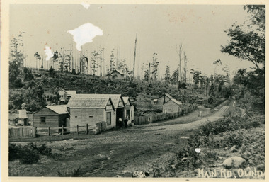 Mt Dandenong & District Historical Society Inc.
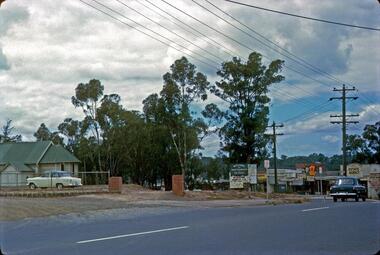
Photograph, Main Street Olinda c1908
c1908 view of Main Street Olinda with Dodd's store in foreground and Olinda State School up on the hill. Reverse of photograph has handwritten description by John Lundy-Clarke.Photo of Olinda taken about 1908 showing State School on skyline. Dodd’s store in foreground. Hodges blacksmith shop on roadside right. Coonara Road, then Mernda Road leads up out the picture right, Mt Dandenong Road goes down left. Range Road (the bullock track) is in immediate foreground and Sassafras turns to the right before the visible tracks on Mernda Road.olinda, jack dodd, general store, school -
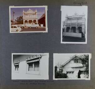 Glen Eira Historical Society
Album - Album page, Orrong Road, Circa 1972
This photograph is part of the Caulfield Historical Album 1972. This album was created in approximately 1972 as part of a project by the Caulfield Historical Society to assist in identifying buildings worthy of preservation. The album is related to a Survey the Caulfield Historical Society developed in collaboration with the National Trust of Australia (Victoria) and Caulfield City Council to identify historic buildings within the City of Caulfield that warranted the protection of a National Trust Classification. Principal photographer thought to be Trevor Hart, member of Caulfield Historical Society. Most photographs were taken between 1966-1972 with a small number of photographs being older and from unknown sources. All photographs are black and white except where stated, with 386 photographs over 198 pages.Victorian Heritage Database https://vhd.heritagecouncil.vic.gov.au/places/35576 No. 70 Orrong Road is important as an exceptionally ornate Boom style villa residence in the terraced form and in this respect is rare in Caulfield. Its architectural value is enhanced by its intact state and by the manner in which its bold architectural expression is carried through into the hallway and staircase. Victorian Heritage Database - National Trust local significance 284 Orrong Road Caulfield https://vhd.heritagecouncil.vic.gov.au/places/65700 A house designed by Harold Desbrowe Annear in 1917 and believed to have been the first "all electric" house in Melbourne. It has been extensively altered.Page 164 - four photographs of 2 different houses on Orrong Road. The top left photo is in colour while the others are in black and white.Handwritten: Orrong Road [top right] / Lisborn House [ (ed. correct name is LISBON HOUSE), under top left photo] / Lisborn House [under top right photo] / [under bottom right photo] / CORNER ORRONG ROAD AND PEARSON AVENUE / HOUSE BY DESBROWE ANNEAR [under bottom left photo] / 164 [bottom right]trevor hart, orrong road, lisbon house, lisborn house, elsternwick, pearson grove, st kilda east, caulfield north, terrace houses, cast iron work, verandahs, balconies, parapets, arches, cars, streetscapes, attic houses, desbrowe annear -
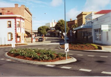
 Eltham District Historical Society Inc
Photograph, Main Road from Eltham Shire Council offices at 895 Main Road, Eltham, c.Apr. 1988
35mm colour positive transparency (3 of 7) Mount - white plasticProcess Date APR Meltham, main road, roads, infrastructure, roundabout, eltham shire office, our lady of help christians church -
 Eltham District Historical Society Inc
Photograph, Eltham, Main Road looking north towards Shire Office. Widening of Main Road, 1968
Source: Shire of Eltham This photo forms part of a collection of photographs gathered by the Shire of Eltham for their centenary project book,"Pioneers and Painters: 100 years of the Shire of Eltham" by Alan Marshall (1971). The collection of over 500 images is held in partnership between Eltham District Historical Society and Yarra Plenty Regional Library (Eltham Library) and is now formally known as the 'The Shire of Eltham Pioneers Photograph Collection.' It is significant in being the first community sourced collection representing the places and people of the Shire's first one hundred years.Digital imagesepp, shire of eltham pioneers photograph collection, eltham, main road, duplication, road widening -
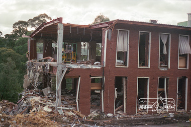 Eltham District Historical Society Inc
Negative - Photograph, Harry Gilham, Demolition of Eltham Shire Offices (South Wing viewed from Main Road), 895 Main Road, Eltham, Aug. 1996
The Shire Offices opened in 1965 and were extended in 1971. The final Eltham Shire Council meeting was held in December 1994 before the forced amalgamations of municipal councils by the Kennett Government. The State-Government-appointed Commissioners (1994-1996) took the decision in July 1996 to demolish the Eltham Shire Offices. The demolition works started within 24 hours of the decision being made.Roll of 35mm colour negative film, 5 of 6 strips Associated printKodak Gold 100-5eltham shire office, demolition -
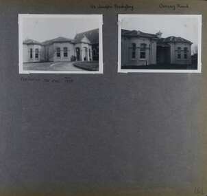 Glen Eira Historical Society
Album - Album page, St Joseph's Presbytery, Orrong Road, Circa 1972
This photograph is part of the Caulfield Historical Album 1972. This album was created in approximately 1972 as part of a project by the Caulfield Historical Society to assist in identifying buildings worthy of preservation. The album is related to a Survey the Caulfield Historical Society developed in collaboration with the National Trust of Australia (Victoria) and Caulfield City Council to identify historic buildings within the City of Caulfield that warranted the protection of a National Trust Classification. Principal photographer thought to be Trevor Hart, member of Caulfield Historical Society. Most photographs were taken between 1966-1972 with a small number of photographs being older and from unknown sources. All photographs are black and white except where stated, with 386 photographs over 198 pages. St Joseph's buildings and grounds are contributory properties to HO72 Elsternwick Estate and environs - City of Glen Eira.Page 162 - two photographs of St Joseph's Presbytery, Orrong Road.Handwritten: St Joseph's Presbytery Orrong Road [top right] / PREVIOUSLY "THE EMS" 1908 [under left photo] / 162 [bottom right]trevor hart, orrong road, curved windows, decorative brackets, arched windows, bay window, portico, slate roof, st joseph's presbytery, catholic church, st joseph's church, st joseph's primary school, porte cochere, the ems, elsternwick, rendered walls, clergy residences, drives, late victorian style, house names -
 Stawell Historical Society Inc
Photograph, Gold Reef Mall -- Main Street Stawell 2003
Gold Reef Mall Main Street 2003Colour Photograph: Looking West showing the Main Street / Patrick Street intersection.stawell business -
Stawell Historical Society Inc
Photograph, Commonwealth Federation Monument in Main Street Stawell 1904, 27 December 1904
Commonwealth Memorial Lower Main Street StawellErected in Honor of First ParlimentPostcard with Stamp of Commonwealth Monument Main Street. Boys Sitting around BaseFront- Souvenir From Stawell (Victoria) A Picard - Stawell) Commonwealth Monument. Rear - Miss K A Simpson Young House Parkside S.A.stawell