Showing 2634 items
matching otway-reef
-
 Bendigo Historical Society Inc.
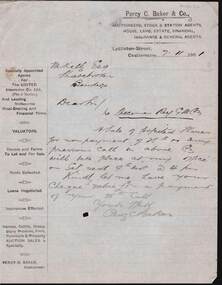
Document - KELLY AND ALLSOP COLLECTION: LETTER FROM PERCY C. BAKER TO M.KELLY, 07/11/1901
Document. KELLY & ALLSOP COLLECTION. One page handwritten letter, dated 7 Nov. 1901, from Percy C. Baker, Auctioneer of Lyttleton St., Castlemaine to M.Kelly Esq, Sharebroker, Bendigo. Relates to sale of forfeited Specimen Reef G.M.Co., shares for non payment of call. Auction to take place at Baker's office on 9th Nov. Letter written under Percy C. Baker & Co. printed letter head that outlines all the functions of tPercy C. bakerbusiness, stockbroker, kelly & allsop, kelly & allsop collection, percy c. baker, m.kelly, letter, specimen reef gold mining co. -
 Bendigo Historical Society Inc.
Document - DRAINAGE PROBLEMS - DRAINAGE PROBLEMS VICTORIA QUARTZ
Handwritten copy of Bendigo Advertiser report 22/6/1910. 'Victoria Quartz. At time of inrush of water on Tuesday night, the shaft had reached a depth of 4,614 feet. Water has since risen in the shaft to above the 4,154 ft. plat and the large workings at 4,254 feet and 4,154 feet have also been filled. As there are no reef workings from 4154 feet to 3,424 feet, the waters will no doubt rise rapidly until that level is reached'.document, gold, drainage problems, new chum drainage association - drainage problems victoria quartz, bendigo advertiser 22/6/1910 page 7, victoria quartz -
Bendigo Historical Society Inc.
Document - WINDMILL HILL - PRODUCTION STATISTICS
Handwritten copy of production statistics from Windmill Hill. Some of the Miners were: Sullivan and his sons, Lindsay and Taylor, Thorpe & Co and Mr Lansell. The mines mentioned are: Confidence Lease, Central Windmill, Cinderella Claim,Confidence Extended, Extended Hustlers, Carlisle, Garden Gully, Johnsons Reef, United Hustlers & Redan, North Johnsons and United Devonshire. Also a piece of paper (b) with Johnsons Group See Annals of Bendigo 1872. Page 140.document, gold, windmill hill, windmill hill, production statistics, sullivan and his sons, lindsay and taylor, thorpe & co and mr lansell, confidence lease, central windmill, cinderella claim, confidence extended, extended hustlers, carlisle, garden gully, johnsons reef, united hustlers & redan, north johnsons and united devonshire. a m s special edition 1/6/1899 page 47, annals of bendigo 1872 page 140 -
 Bendigo Historical Society Inc.
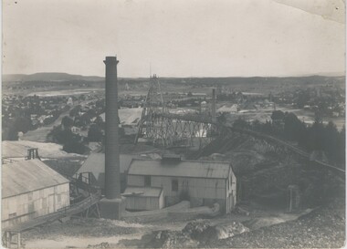
Photograph - LANSELL'S 222 MINE
black and white photo: Lansell's 222 mine. Various poppet heads in distance, chimney, poppet head and mine buildings in foreground. On back of photo: 'Lazarus Enginehouse; 3,650 ft. ' Lansell's 222. Taken from Old Chum Hill. New Chum Line. ' View from Chum looking at the 222 mine - Sheepshead Line of Reef on left. ( J. Lerk 26.11 1999 ) Bottom right hand Corner A Richardson 29 Harrison Street BendigoVincent Kelly Bendigo - embossed bottom right corner.organization, business, lansell's 222 mine -
Bendigo Historical Society Inc.
Map - HUSTLER'S ROYAL RESERVE NO 2 MINE - PLAN OF THE HUSTLER'S ROYAL RESERVE NO 2 MINE
Plan of the Hustler's Royal Reserve No 2 Mine on the Hustler's Line of Reefs Bulletin No 33, Plate No VI. Boundary of Leases No 8898 and 8897 shown. Various levels shown and some geographical features. Geological Survey of Victoria emblem. H . Harman, Director, W. Dickson, Secretary for Mines and The Hon. J. Drysdale Brown, Minister of Mines and signed by H Whitdon, Underground Survey Office, Bendigo, September 1913. This item has not been scanned or photographed.mining, parish map, hustler's royal reserve no 2 mine, plan of hustler's royal reserve no 2 mine, hustler's line of reefs, geological survey of victoria, h herman, w dickson, the hon j drysdale brown mlc, h whitdon -
Bendigo Historical Society Inc.
Map - UNITED HUSTLER'S & REDAN MINE - TRANSVERSE SECTION UNITED HUSTLER'S & REDAN MINE
Transverse Section of the United Hustler's & Redan Mine on the Hustler's Line of Reefs Bulletin No 33, Plate No XXIX. Map has drawing of poppet legs on the surface, depth of levels, type of stone encountered and some geological features. Sill of shaft 745.62 ft above sea level. Map has Geological Survey of Victoria emblem and signed by H S Whitelaw, Underground Survey Office Bendigo, 'September 1913. This item has not been scanned or photographed.mining, parish map, united hustler's & redan mine, hustler's line of reef, geological survey of victoria, h s whitelaw -
Bendigo Historical Society Inc.
Map - COMET MINE - LONGITUDINAL SECTION COMET MINE
Longitudinal section of the Comet Mine on the Hustler's Line of Reef Bulletin No 33, Plate No XXVI signed by H. S. Whitelaw, Underground Survey Office Bendigo, September 1913. Map shows datum lines, depths of levels, approximate boundaries and references to other plans. Note - Plates 4, 8, 13, 20, 26 and 31 form a Longitudinal Section from Fortuna Hustler's to Hustler's Consols Mine. This item has not been scanned or photographed.Geological Survey of Victoriamining, parish map, hustler's line of reef, longitudinal section of comet mine bulletin no 33 plate no xxvi, h s whitelaw, underground survey office bendigo september 1913 -
 Waverley RSL Sub Branch
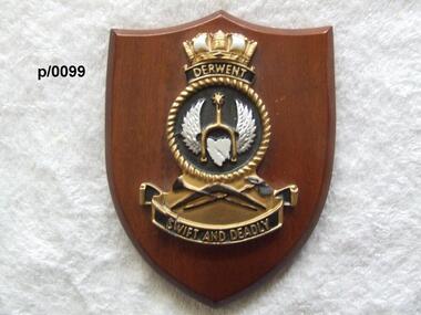
Plaque H.M.A.S. Derwent
HMAS Derwent (F22/DE 22/DE 49), named for the Derwent River, was a River class destroyer escort of the Royal Australian Navy (RAN). Commissioned in 1964, the ship operated during the Indonesia-Malaysia Confrontation, and was used for filming of the British drama series Warship. The ship was decommissioned in 1994, and was scutted as an artificial reef after use for ship survivability testsInsignia od H.M.A.S. Derwent on wooden shieldH.M.A.S. Derwenth.m.a.s. derwent -
Glenelg Shire Council Cultural Collection
Book, Halstead Press, Wreck of the Admella, 1966
Blue hard-copy book. Gold text on spine. Two double-sided pages of black & white photos half way through book. Book has dust jacket with coloured reproduction of a painting of the wreck of the Admella, by Charles Hill. Photo of author inside back of dust jacket.admella, portland lifeboat, book -
 Warrnambool and District Historical Society Inc.
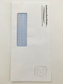
Document - Ludeman Real Estate envelope, Early 21st century
This is an envelope used in the business of Ludeman Real Estate, Warrnambool. The Director, Bruce Ludeman, had previously been a stock and station agent before establishing his real estate business in Warrnambool in 1985. Bruce Ludeman, a business broker, auctioneer and property manager, is President of the Otway Division of the Real Estate Institute of Victoria and received a Presidents Award in 2012 for services to the real estate industry in the Western District. This envelope is of minor interest as an example of the type of business envelope used today in the real estate businesses in Warrnambool. This is a business-type white envelope with a see-through insert to show the address. It is self-sealing. The name and business address of Ludeman Real Estate is printed at the top left hand corner of the envelope. It also has a stamp to show that postage has been paid. ‘Ludeman Real Estate p/l 122 Liebig Street Warrnambool Victoria 3280’history of warrnambool, businesses in warrnambool, ludeman real estate, bruce ludeman, warrnambool history, liebig street -
 Parks Victoria - Gabo Island Lightstation
Locker, flag
Probably used in the past to house the Signal Flag set at the lightstation. Appears to have been stored in the old stables for a number of years.The rectangular wooden cabinet has the distinctive features of a flag locker, comprising numerous open compartments of the same size each for storing a signal flag of a unique design. It has three internal shelves and a bench top, and is painted grey, a colour that is used for many of the wooden utilitarian furnishings in the six lightstations Parks Victoria manages. The cabinet, without its flag contents, was found in storage in the old stone stable building and is highly likely to be original to the lightstation. A wooden flag locker is held at Wilsons Promontory Lightstation. A wooden locker comprising two sections of 16 pigeon holes and four cupboard doors is held at Cape Otway The two flag lockers at Cape Nelson Lightstation are included in Victorian Heritage Register for contributing to the significance of the lightstation. The Nelson, Otway and Promontory lockers have associated sets of flags which are original to the lightstations. The Gabo Island cabinet has second level contributory significance for its provenance to the lightstation.Timber cabinet painted grey, partitioned with numerous open compartments of the same size . -
 The Beechworth Burke Museum
Photograph - Photograph - Reproduction, Unknown
This image is a reproduction of an 1899 original depicting the 'Williams Good Luck Mine' on the Mopoke Reef (also called 'Morepork Gully') in the Dingle Ranges, approximately three miles from Beechworth. The foreground of the image is littered with piles of smashed rock and detritus, known as ‘mullock’, beside a reinforced mine shaft, a vertical access passageway allowing miners to enter the mine and haul ore out using lifting technology such as a poppet heads, whims or windlasses. A group of miners and a dog appear close to an open-sided miner’s hut. Following the discovery of gold at Beechworth in 1852, rushes quickly followed at surrounding creeks and gullies in the district. In the late nineteenth and early twentieth centuries, small syndicates of miners continued to work old or abandoned quartz reefs, often persisting without the assistance of heavy machinery to remove the large amounts of rock, in order to obtain yields at ever greater depths. The group of miners in this photograph are Mr. Roger Williams and Sons, who revived operations at the ‘Old Good Luck’ mine on the Mopoke Reef in the Dingle Range near Beechworth around 1892, working the site for more than two decades. An emigrant from Cornwall with experience in the tin mining industry, 19 year old Roger Williams senior sailed to New Zealand in 1840, then to Australia where he spent time in the Bendigo Gold Fields before settling in Beechworth in the early 1860s. Mr Williams senior worked on various mining activities in the district, including the Rocky Mountain Tunnel project. Conversant with the character of gold-bearing reefs in the area, the syndicate dug an eight hundred foot tunnel, digging down as far down as two hundred feet with little capital save their labour, to connect and provide better working access to the mass of reefs and veins in the vicinity. Progress was hampered by poor air quality charged with fumes from dynamite and large quantities of rock had to be crushed to obtain payable yields. The Victorian Goldfields are filled with ruins and remnants of the area's rich mining history, ranging from small alluvial diggings to the remains of huge mining companies. Site names often changed several times throughout the nineteenth and twentieth centuries. Some sites were abandoned and forgotten, others were worked continuously over many decades. The names of mines were often repeated at different locations throughout the Victorian Goldfields. For example, there is a Mopoke Gully heritage mine near Fryers Creek, Victoria. 'Mopoke' is a common onomatopoeic name for Morepork and Australian Boobook owls. This image has historical, social and research significance for patterns of emigration during of the Victorian Gold Rush, and the historical, social and environmental impacts of mining at Beechworth at the turn of the nineteenth and twentieth centuries. As gold became scarce and government support and large company investment waned, poor hard-working miners laboured intensively to make a living through periods of high unemployment. This image can be compared and studied alongside other historical mining photographs and objects in the Burke Museum Collection. It has potential to improve our understanding of miners working conditions and the shifting character of mining in the Beechworth district. Black and white rectangular reproduction photograph printed on matte photographic paper.Obverse: Williams Good Luck Mine Beechworth / Roger! / Reverse: 6858 / burke museum, beechworth museum, beechworth, gold fields, gold rush, victorian gold rush, gold ming history, colonial australia, australian gold rushes, mining technology, beechworth historic district, indigo gold trail, migration, indigo shire, good luck gold mine, victorian goldfields, mining syndicates, gold fever, quartz-mining, small-scale mining, old good luck mine, mopoke gully, quartz reefs beechworth -
 Bendigo Historical Society Inc.
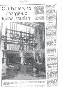
Newspaper - LONG GULLY HISTORY GROUP COLLECTION: OLD BATTERY TO CHARGE-UP TUNNEL TOURISM
Three photocopies of a newspaper article titled Old Battery to charge-up tunnel tourism. The date 11/1/85 is written at the top of the article. There is a photo of the battery mentioning it was the Thompson's Foundry battery and it was being re-erected at Maldon, near Castlemaine. It has been in far of Victoria to crush rock taken from mines there. The battery will be one of the attractions in the Parkin's Reef Reserve being developed by the Conservation, Forests and Lands. Also mentioned is the work of volunteers, grants they received, restoration and tourism.bendigo, history, long gully history group, the long gully history group - old battery to charge-up tunnel tourism, thompson's foundry, parkin's reef reserve, conservation forests and lands department, carman's tunnel, north british mine, parkin's reef, carman's tunnel committee, dr doug kemsley, prospectors' and miners' association of victoria, ken garden, north british mine, george ellis -
 Bendigo Historical Society Inc.
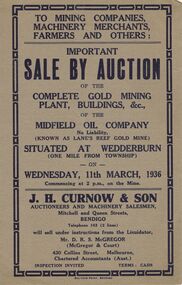
Document - IAN DYETT COLLECTION: AUCTION CATALOGUE - MIDFIELD OIL COMPANY (KNOWN AS LANE'S REEF GOLD MINE)
Grey covered auction catalogue with dark blue printing for a sale of the Complete Gold Mining Plant, Buildings, &c. of the Midfield Oil Company No Liability (Known as Lane's Reef Gold Mine), situated one mile from the Township of Wedderburn. Sale was held on the 11th March, 1936 under instructions from the Liquidator, Mr. D. R. S. McGregor (McGregor & Court). J. H. Curnow & Son were the auctioneers and the catalogue was printed by Boltons Print, Bendigo.business, auctioneers, j h curnow & son pty ltd, ian dyett collection - auction catalogue - midfield oil company no liability (known as lane's reef gold mine), j h curnow & son, mr d r s mcgregor, mcgregor & court, boltons's print bendigo -
Bendigo Historical Society Inc.
Photograph - PURDY COLLECTION: PALL MALL PHOTO
Sepia image of Pall mall, taken from just south of the Alexandra Fountain. Shows horse drawn vehicles, people walking. Women dressed in long dresses, tramline on road, tram heading up towards View Street. Poppet head and mining chimney of Royal Reserve mine on LH side of Pall Mall. Post Office and Shamrock buildings on either side in mid-ground. On back of image in biro 'Royal Reserve G.M., Hustlers line of reef, Pall Mall, Bendigo.'bendigo, streetscape, pall mall -
 Bendigo Historical Society Inc.
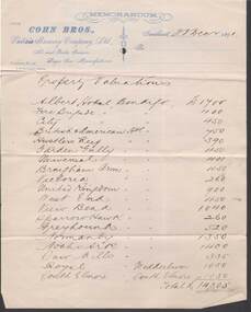
Document - COHN BROTHERS COLLECTION: LIST OF PROPERTY VALUATIONS DATED 1891
Printed Cohn Bros Memorandum letterhead notepaper dated 23rd Dec 1891 with handwritten 'Property Valuations'. Nineteen Cohns Hotels with 1891 valuations are listed. These include: Albert Hotel, Fire Brigade, City, British American, Hustlers Reef, Garden Gully, Universal, Brougham Arms, Victoria, United Kingdom, West End, View Bend, Sparrowhawk, Greyhound, Normanby, Noahs Ark, Saw Mills, and the Royal at Wedderburn, as well as the South Elmore at the township of Elmore. These totalled £14,305bendigo, industry, cohn bros brewery -
 Bendigo Historical Society Inc.
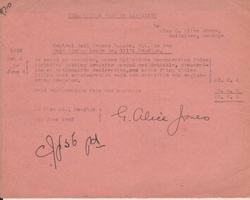
Document - MISS G ALICE JONES COLLECTION: ACCOUNT
Nell Gwynne Reef NO Liability to Miss G. Alice Jones. Pink paper dated Feb. 3 to June 4 1942, 9 June 1942 and 9th June 1942. Re Central Nell Gwyne G. M. Co. N. L. to you Gold Mining Lease No. 11171 Bendigo. Account for costs for transfer, registration fees and exchange. Total cost £5. 7. 0. "R710" written in top left corner. Signed by G. Alice Jones.miss g. alice jones collection - account, nell gwynne reef n. l., central nell gwynne g. m. co n. l., lease no 11171 -
Bendigo Historical Society Inc.
Document - ALBERT RICHARDSON COLLECTION: UNITED HUSTLERS AND REDAN MINE
Four page typed document plus location map. The United Hustlers and Redan mine was located in the North Bendigo, Long Gully area on the Hustlers line of reef.. The lease was 153 acres and included Holdsworth, Holmes, Havilah Roads and Wood Street. The Redan shaft was 1,830ft and the South or K.K. Shaft was 1,960 ft. Poppet legs steel 71 ft high. Features of the plant are described including the engine house, winding engine, air compressor, boilers, fuel, winding ropes.bendigo, mining, united hustlers and redan mine -
Bendigo Historical Society Inc.
Newspaper - NEW CHUM RAILWAY MINE - LAST YEARS OF MINE CAPTURED IN POSTCARD FORM
Newspaper article titled 'Last Years of Mine captured in Postcard Form' from the Bendigo Miner, Thursday, December 15, 2011 by Ian Fenselau. Article mentions some history of the mine, how it got it's name, depth of the mine and it's comparison with the Victoria Reef Quartz. It also mentions the death of James Nolan when he fell down the shaft and studies of ventilation released by Dr Walter Summons. The machinery foundations are still visible in Golden Square.newspaper, bendigo, the bendigo miner, new chum railway mine, last years of mine captured in postcard form, ian fenselau, victoria reef quartz mine, james nolan, dr walter summons -
Bendigo Historical Society Inc.
Map - K. K. MINE - TRANSVERSE SECTION K. K. MINE
Transverse Section of the K. K. Mine on the Hustler's Line of Reefs, Bulletin No 33, Plate No XXXII. Map shows the different levels and their depth. Also the different types of stone encountered and geological features such as spurs and faults. Has drawing of the poppet legs at the top of the shaft and sill of shaft 773.56 ft above sea level.Map has Geological Survey of Victoria crest and signed by H S Whitelaw, Underground Survey Office Bendigo, September, 1913. This item has not been scanned or photographed.cottage, miners, fortuna hustler's mine, transverse section of k. k. mine, hustler's line of reefs, geological survey of victoria, h s whitelaw -
Bendigo Historical Society Inc.
Document - HUSTLERS REEF MINE - REFERENCE FOR WM RICHARDSON
Hand written reference for William Richardson. It mentions he has been employed as an engine driver and is very handy at smith work. Signed by Tho Tregear, Mining Manager from the Hustlers Reef No 1 G. M. Co. Dated July 4th 1896. Blue stamp of Royal Historical Society of Victoria, Bendigo Branch in the top left corner. Also another piece of paper mentioning William Richardson is the grandfather of Albert Richardson who wrote notes on mines.mine, gold, hustlers reef mine, hustlers reef no 1 co, william richardson, tho tregear -
 Bendigo Historical Society Inc.
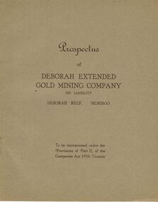
Document - MCCOLL, RANKIN AND STANISTREET COLLECTION: DEBORAH EXTENDED GOLD MINING COMPANY NL, 1940
McColl Rankin & Stanistreet, 12 Copies of Prospectus of Deborah Extended Gold Mining Company No Liability, Deborah Reef, Bendigo. To be incorporated under the Provisions of Part II, of the Companies Act 1938, Victoria. Application form and map of mines included in book form, dated 1940. Profit and Loss Account for Term ended 31st August, 1945 also included on separate sheet (has been folded in half across). Auditors: Wm. R. McKie & W. J. Sparkman.organization, mining, deborah extended gold mining cpy nl, mccoll rankin & stanistreet, deborah extended gold mining company nl, prospectus, profit and loss account for 31 august 1945, map of mine, form application -
Bendigo Historical Society Inc.
Document - Fortuna Bendigo, letter of re classification by the National Trust and History Brochure, 20/10/2008
The Fortuna Villa is an expansive Victorian mansion built entirely on the profits of Bendigo's lucrative gold reefs. Established by the wealthy Ballerstedt family in the 1860s, it was purchased and expanded in the 1870s by George Lansell, who was to become one of Australia's wealthiest men. Fortuna villa and gardens were once occupied and cared for by the Australia Army Survey Regiments since 1942 for over thirty years.Classification Report and Notes on the history of Fortuna from the National Trust to the Bendigo Council 20th October 2008; tourist brochure for Fortuna; it includes photographs and detailed history of George Lansell's involvement in the property and his mining history.history, national trust bendigo collection, bendigo, fortuna, george lansell, mining -
Bendigo Historical Society Inc.
Document - MINING IN BENDIGO COLLECTION: UNEARTHED QUARTZ CRUSHER
Typed notes mentioning the early pioneers of Bendigo Gold Mining. Some of them are: Messrs Ballerstedt, Wittschiebe, Luffsman, Roeder Lazarus, Kock, Hildebrandt, Bruhn,Miller, Annear, Wells, Rae,Jackson, Woodward, Sterry, Burrowes, Thorp, Heine, Holmes, Gould, Allen, Brooks, Watson and Geo Lansell. In 1911 a quartz crusher was unearthed in McCrae Street during excavations at the site of the new St.Kilian's Girls Club Rooms. It was used by the late Mr. James Irons. It was found at a depth of ten feet. Mr. Angus Kennedy, who believed that he manufactured the plant for Mr. Irons, said Mr. Irons used to crush very rich quartz from the Sheepshead Reef, south of the Big Blue Battery. Some years ago, a solid granite stone-crusher was seen at Diamond Hill. It was at the site of the old Diamond Hill Hotel. The Comet Reef was found by Mr. Driesslau, who found gold in an outcrop when he was shooting parrots. Also mentioned is the tunnel that goes right through Diamond Hill.document, gold, mining in bendigo, mining in bendigo, unearthed quartz crusher, messrs ballerstedt, wittschiebe, luffsman, roeder lazarus, kock, hildebrandt, bruhn, miller, annear, wells, rae, jackson, woodward, sterry, burrowes, thorp, heine, holmes, gould, allen, brooks, watson, geo lansell, bendigo advertiser april 28th 1911, st kilian's girls' club rooms, mr james irons, mr angus kennedy, sheepshead reef, big blue battery, diamond hill hotel, victoria proprietary ltd., comet reef, mr driesslau, diamond hill tunnel -
Bendigo Historical Society Inc.
Book - MINING REPORTS - THE CONFIDENCE GROUP OF MINES BULLETIN NO 41
Light brown covered booklet 'Bulletins of the Geological Survey of Victoria issued by W Dickson, Secretary for Mines, Under the Authority of the Hon. S Barnes M L A Minister of Mines. No 41 The Confidence Group of Mines, Bendigo with Plans and Sections by H S Whitelaw, Field Geologist, dated 1918. Mines mentioned are: Confidence Extended Mine, Confidence Tribute Company and the Central Windmill Hill Mine. Mentioned in the report are crushings and gold yield, details of levels, names of leases along the reef. Extracts from Mine Manager's Half-yearly Reports, 1878-1915 of tons crushed and gold yield. Plans and sections of the Confidence Extended Mine on the Garden Gully Line of Reefs are: Plate I General Plan of All Levels, Plans of Levels Plate No II, Plans of Levels Plate No III, Transverse Section Plate No IV, Longitudinal Section Plate No V, and Central Windmill Hill Mine Transverse Section Plate No VI. Plates signed by H S Whitelaw 17 & 18/6/16 and 20/7/16.book, bendigo, mining reports, mining reports, the confidence group of mines bulletin no 41, confidence extended mine, confidence tribute company, central windmill hill mine, department of mines, bulletins of the geological survey of victoria, w dickson, the hon s barnes, h s whitelaw, h j green, mr robert eddy, mr w h cundy, j foster, c j thompson -
 Otway Districts Historical Society
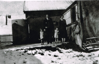
Photograph, Laurie McCabe, wife and children at their railway house, Beech Forest, Mid 1920s
In order to accommodate its key Otways staff of train crews, station masters and gangers the VR provided departmental housing. Laurie McCabe, a former porter at Wyelangta, a player in the local football team, and married to one of the potato-growing families, was the Station Master becoming the travelling station master and guard in 1930. He was based in Beech Forest and housed departmentally with his wife, Victoria Elizabeth (nee Tann) and their two children.Laurie McCabe, Travelling Station Master and goods Guard, his wife, Victoria, and their two children outside their railway house at Beech Forest. B/W.beech forest; railway; departmental housing; -
 Federation University Historical Collection
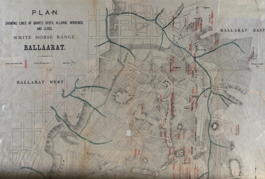
Plan, White Horse Range Ballarat, 1885, 06/1885
Two plans .1) Plan of the Ballarat Goldfields showing leads, rivers, streets and topography. Quartz reefs include: Yorkshire, Try Again, Promised Land, Western Slates, Norwegian, Robert's Lode, Finn's, Band and albion, Rothschild, Old Post Office, Queen Lode. Leads include: Navy jacks, Gays, Canadian, Prince Regent, Sailors Gully, White Horse, Little White Horse, Milkmans, Nightingale, Golden Point, Gravel Pits. Scale is 8 Chains to 1 inch .2) Plan showing lines of quartz reefs, alluvial workings and leads, White Horse Range, Ballarat. Leads include White Horse LEad, Little White Horse Lead, One Eye Gully, Terrible Lead, Sailor's Gully, Canadian Lead, Prince Regent Gully, Canadian Lead, Cavs Lead, Navy jacks Lead, Eureka Lead, Old Gravel Pits Lead, Gravel Pits Lead, Nightingale Lead, Malakoff Lead, Milkmans Lead, Redan Lead, Woolshed Lead, Jacksons Lead, Winters Lead, SCtochman's Lead, Canadian Lead. Reefs include: Promised Land, Daniash, Sir Garnet Wolsley, Norwegian, Rothschile, Band and Albion, Finns, Llanberis, Roberts Lode, Tynworths and Black Hill, Oregan, Yorkshire, Try Again, Yorkshire, Post Office, Clarke's, Western Slates, Black Slate, Danks Slates, Eastern Slates, Queen's Lode, Fire Brigade. Mines include Red Streak, New Chum, Tinworths, Woah Hawp, Normanby, Speedwell, Llanberris Extended, Llanberis, Last Chance, Major, Countess, Pioneer and a number of batteries along Main Road Hills include: Mount Clear, Pennyweight Hill, Sovereign Hillballarat, plan, white horse range, white horse, goldfields, mines, reefs, indicators, leigh river, cgt, tinworth, mining -
 Federation University Historical Collection
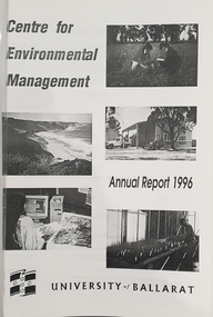
Booklet, University of Ballarat Centre for Environmental Management, 1996
The Centre for Environmental Management as established in July 1995 as a strategic development initiative to consolidate the University's position as a centre for industry linked environmenttal teaching, resarech and consultancy. Page 19 "SPECIAL INITIATIVES Establishment of field Research Stations Two areas of concentration of research effort for the Centre are the Otways in the south western Victoria and the Scotia Country in the rangelands of NSW. In both these areas it is essential that ther be a secure accomodation abase for research students. In the former case there is a need for a sheltered base to enable year round field work in cold wet conditions and in the latter a base with a reliable water supply and the facilities to allow field work in very hot dry conditions which prevail from much of the year. It has been an ibjective of the Centre to establish field stations at these two sites and considerable progress has been made through the year. (i) Nanya Field Station in the Scotial Country Through the generosity of the owner, Mr Rob Taylor, an unused homestead on Nanya Station was made available to the Centre. Largely through voluntary labour during research field trips during the year this previously derelict homestead has been restored to functionality and now has facilities for up to 20 research workers with a reliable water supply, cooking, washing, and refrigeration facilities. (ii) Cape Otway Resaerch Centre Negotiations have continued through the year with the potential lessees of the Cape Otway Lighthouse Precinct with the support of the Vice Chancellor and other potential user groups within the University these have reached a successful outcome. The University will be working with the lessees to develop the historic Telegraph Station as a dual purpose facility for interpretation and research." Black and white cover with clear plastic sheet. university of ballarat, centre for environmental management, martin westbrooke, richard mcewan, mal weston, john miller, nanya, telegraph station, cape otway, cape otway lighthouse station, cape otway telegraph station, field resaerch stations, s. hadden, peter dahlhaus, r.j. macewan, pat prevett, native vegetation assessment, fauna management, pest plants and animal research, soil and water assessment, conservation reserve management, paul ryan, richard macewan -
 Orbost & District Historical Society
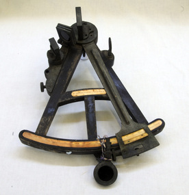
sextant, W. Sutherland
RIDGE PARK, Length: 65.2 m.; Owned by H. Simpson & Sons; Built at S. P. Austin & Sons in 1878. Registered at Adelaide. On 10 February 1881, RIDGE PARK (Capt. Heslop) was on voyage from Adelaide to Sydney with a cargo of brandy, wine and flour, when she was lost after running aground.Beware Reef is located south east of Cape Conran in east Gippsland. This is the sextant from the Ridge Park which, on10 February 1881, was wrecked on Beware Reef , just south of Cape Conran in east Gippsland. An old wooden sextant from the ship, Ridge Park. It is black with yellow measuring stripes.sextant maritime navigational -
 National Wool Museum
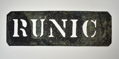
Stencil - RUNIC
This stencil was used as a ship identifier stamp for the transportation of wool bales. SS Runic was the largest refrigerated cargo liner during its time. In 1961 the ship struck the Middleton Reef on route from Brisbane to Auckland. The ship was unable to re-float due to weather conditions and was declared a constructive loss. All wool bales stamped with RUNIC would be transported on the SS Runic ship.Wool bale export stencil - RUNICRUNICwool transportation, wool export, wool sales