Showing 11126 items
matching planning.
-
 Whitehorse Historical Society Inc.
Legal record - Correspondence, East Burwood Reserve, Sportsgrounds, 1/02/1998 12:00:00 AM
Regarding a p roposed playground at East Burwood reservePlaygrounds, Correspondence dated February/March1998 between City of Whitehorse and Bill Sewart Athletic Track Association regarding a p roposed playground at East Burwood reserve including plan. East Burwood Reserve,Sportsgrounds East Burwood Reserve City of Whitehorse Bill Sewart A thletic Track association Regarding a p roposed playground at East Burwood reservesportsgrounds, east burwood reserve, city of whitehorse, bill sewart athletic track association, playgrounds -
 Melbourne Legacy
Document, Stanhope
Documentation dated January 1974 obtained by Legatee Trebilcock as a member of the Steering Committee (Residences) which had been formed to advise on the future of the Melbourne Legacy residences. See also Cat.No. 01676. The document describes the location and the buildings in detail and advises that Stanhope appears to be satisfactory for its purpose and easily converted to a co-ed facility. The photocopied plan is also dated January 1974, but the definition is poor. Items were compiled in a folder with documents pertaining to the residences. Stanhope was at 1245 Burke Rd Kew and was owned by the Red Cross.Part of the history of Melbourne Legacy's involvement with residential care for children.Photocopies x 5 pages, black on white. Photocopied architectural plan, black on white paper.residences, review, committee, stanhope -
 Parks Victoria - Mount Buffalo Chalet
Plans x 4, " Additions to Government Chalet Mt Buffalo
Original plans for the Mount Buffalo Chalet, framed architectural drawings for the Chalet, titled " Additions to Government Chalet Mt Buffalo. Dated 1909. Signed Jas G Spence & E F Leary. "Ground Plan, first floor plan, elevation, Section M5 and side elevation –beautiful coloured plan, hand price onit of £970, also called Drawing No. 1.Beautiful plan suitable for reproduction for graphic work." (Pg 45. Heritage Impact Assessment, September 2013. MGS Architects and McDougall & Vines, Conservation and Heritage Consultants) 'The Mount Buffalo Chalet opened in April 1910 as a remarkable Victorian State government venture into alpine tourism and recreation. Designed by Public works Department architect, George Austin (1860-1921)." (Pg 4 Historica, 2011). "The collection of ephemera builds on the Chalet's holding of archival material with a range of interesting, original items. Dinner menus., stationery., luggage labels, tickets, dockets and plans help to interpret the structured routine and social conventions of the Chalet that held sway for so many years." (pg 127 MBCC) These plans drawn were most likely to have been drawn upon recommendation by Government Tourist Officer, J.C.Boyce. John Newton (the Lessee) suggests the addition of 2 new wings (24 rooms) and creation of a billiards room. Treasury approved money for these extensions which were not completed until1914. Listed in Draft Inventory of Significant Collection Items. Four framed hand-drawn and coloured drawings / plans of the Chalet. Framed and mounted behind glass. 1: Dated 1911 -1912. 2: -dated 6th oct 1909 3: -Dated 25th Sept 1909. 4: -Dated 6th Oct 1909.Handwritten at the top of each drawing," Mount Buffalo / Wood Chalet" -
 Whitehorse Historical Society Inc.
Article, Volunteers set to work on heritage grounds, 2006
Volunteers to be enlisted to restore historic Crown Land abutting Schwerkolt Cottage, known as 'The Horse Paddock' (photo)Volunteers to be enlisted to restore historic Crown Land abutting Schwerkolt Cottage, known as 'The Horse Paddock' (photo) Judith Fry, Barbara Gardiner, Rob Hulls (Vic Planning & environment Minister), Sharon Ellis (Whitehorse Mayor)Volunteers to be enlisted to restore historic Crown Land abutting Schwerkolt Cottage, known as 'The Horse Paddock' (photo)voluntary workers, schwerkolt cottage, hull, rob, ellis, sharon, fry, judith, gardiner, barbara -
 Bendigo Historical Society Inc.
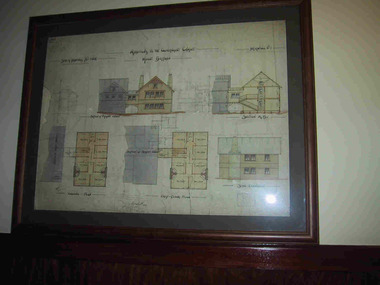
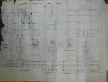
Document - MARKS COLLECTION: PLAN FOR ALTERATIONS AND ADDITIONS TO FORTUNA
Copy of plan: Written on top RH corner of plan 'plan for alteration and additions to the private residence of Geo Lansell Sandhurst' Plan shows western, southern, and eastern elevations, plus roof plan. Bottom section of plan damaged. On bottom of plan '1/8 inch to one foot.'buildings, house, fortuna villa -
 Warrnambool and District Historical Society Inc.
Documents, Swintons Paper att 18/53 Merri St. Contract. Map. Notes, 1959
These documents relate to the sale of land in Merri Street Warrnambool in 1959 by Swintons Pty Ltd of Warrnambool. The buyer of the land was George O’Grady, a Warrnambool baker. The land sold for £4000 and there was a shed on the land (called the ‘Office’) which George O’Grady indicated he wished to be included in the sale. William and Ann Swinton migrated to Australia in 1854 and for a decade William Swinton worked as a builder and carpenter in the Warrnambool area, erecting many buildings, including the Wangoom Presbyterian Church. In 1865 he opened a store in Timor Street Warrnambool, selling groceries, hardware, china and glassware. By 1888 the business was known as William Swinton and Sons. Branch stores were opened in Wangoom, Cudgee, Nullawarre, South Warrnambool and West Warrnambool. After William Swinton died his son Robert became the first managing director of Swintons Pty Ltd. In 1934 the business split with George Swinton and Sons selling clothing, furnishings and glassware and Swintons Pty Ltd selling seeds, produce and hardware. Today the Swinton family still operates a furniture and bedding shop in Timor St Warrnambool.These items are of some interest as being connected to the Warrnambool business of Swintons Pty Ltd. They will be of interest to researchers. The current Swinton business in Timor Street is the oldest family business in Warrnambool and, with the name Swinton associated with businesses in Timor Street Warrnambool for 152 years it is amongst the oldest family businesses in Australia.The items here relate to the sale of land by Swintons Pty Ltd., Warrnambool. .1 These are three pages of white paper with typed material, a lawyer’s signature in blue ink, one green stamp and a sketch of the land location. .2 This is a sheet of thick paper containing a plan of the land sold. The paper has printed material and a sketch of the land with part of it coloured in pink. .3 This is a small piece of paper torn at the bottom right edge. It has handwritten material (a letter) in blue ink..2 ‘Plan of Survey of Part of Crown Allotment 18 Section 3 Township of .2 ‘Plan of Survey of Part of Crown Allotment 18 Section 3 Township of Warrnambool Parish of Wangoom County of Villiers’ .3 ‘Tuesday Dear Mr Swinton I am writing to say that I would like to have the ‘Office’ Thanking You George O’Grady’swinton family,, warrnambool -
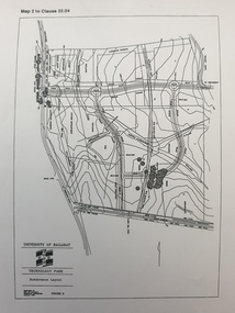 Federation University Historical Collection
Plan, Ballarat Technology Park plans, c1998
.1) Alotment plan .2) contour planballarat technology park, mount helen campus, canadian wetlands, ballarat to buninyong railway line, sub-division layout -
 Kew Historical Society Inc
Map, Real Estate Map of Bulleen, Templestowe, Lower Templestowe, Doncaster, North Balwyn
A large undated printed map of Bulleen, Templestowe, Lower Templestowe, Doncaster, North Balwyn showing major and minor roads, waterways and proposed facilities in this area of Melbourne.A useful if undated real estate map that allows viewers to compare current and historic aspects of these areasMap of Bulleen, Templestowe, Lower Templestowe, Doncaster, North Balwyn used by JB Thomson & Co, Real Estate Agents, to identify and record land sales on these. There are some markings on the plan indicating the location and price of lots.subdivision plans, bulleen, templestowe, lower templestowe, doncaster, north balwyn -
 Kew Historical Society Inc
Map, MMBW, MMBW Plan No.66 Kew, 1900-1910
The Melbourne and Metropolitan Board of Works (MMBW) was established by an act of the Victorian Parliament in 1890 to prepare for and to implement a sewerage and water reticulation system across what was then inner Melbourne, its surrounding and middle distance suburbs, including Kew. The MMBW was disbanded in 1991.The map collection of the Kew Historical Society has at its core the historic maps assembled and originally stored in the City Engineer's Department of the City of Kew. These include maps in a number of scales. The vast majority of maps were produced by the MMBW in the first two decades of the twentieth century, and are solid working maps, backed by linen for durability. These maps are historically significant to Kew, the City of Boroondara and to the history of the development of state utilities in Victoria. A number of the Kew maps have additional details added by former municipal officers, including the levels reached by various floods. As these were working documents, information was added to them long after the period of their initial production and distribution.Early map of part of the Borough of Kew, created in the first decade of the twentieth century, at a scale 160 ft to 1 inch. The map covers what was then the south eastern part of Kew, bordered on its north by Adeney Avenue, in the west by Sackville Street, in the south by Barkers Road, and in the east by Burke Road. The map shows the extent of urban development by that time, prominent institutions and the outlines of built structures in the municipality. Contour lines were added in ink to the map at a later stage.MELBOURNE AND METROPOLITAN BOARD OF WORKS / PLAN NO. 66 / KEW melbourne & metropolitan board of works, mmbw maps, mmbw plans, borough of kew, cartography -
 Kew Historical Society Inc
Map, MMBW, MMBW Plan No.67 Kew, 1900-1910
The Melbourne and Metropolitan Board of Works (MMBW) was established by an act of the Victorian Parliament in 1890 to prepare for and to implement a sewerage and water reticulation system across what was then inner Melbourne, its surrounding and middle distance suburbs, including Kew. The MMBW was disbanded in 1991.The map collection of the Kew Historical Society has at its core the historic maps assembled and originally stored in the City Engineer's Department of the City of Kew. These include maps in a number of scales. The vast majority of maps were produced by the MMBW in the first two decades of the twentieth century, and are solid working maps, backed by linen for durability. These maps are historically significant to Kew, the City of Boroondara and to the history of the development of state utilities in Victoria. A number of the Kew maps have additional details added by former municipal officers, including the levels reached by various floods. As these were working documents, information was added to them long after the period of their initial production and distribution.Early map of part of the Borough of Kew, created in the first decade of the twentieth century, at a scale 160 ft to 1 inch. The map covers what was then the north central part of Kew, bordered on its north by the Outer Circle Railway Spruzen and Beresford Avenues, in the west by Princess Street, in the south by High Street, and in the east by (about) Belford Road. The map shows the extent of urban development by that time, prominent institutions and the outlines of built structures in the municipality. Contour lines were added in ink to the map at a later stage.MELBOURNE AND METROPOLITAN BOARD OF WORKS / PLAN NO. 67 / KEW melbourne & metropolitan board of works, mmbw maps, mmbw plans, borough of kew, cartography -
 Kew Historical Society Inc
Map, MMBW, MMBW Plan No.68 Kew, 1900-1910
The Melbourne and Metropolitan Board of Works (MMBW) was established by an act of the Victorian Parliament in 1890 to prepare for and to implement a sewerage and water reticulation system across what was then inner Melbourne, its surrounding and middle distance suburbs, including Kew. The MMBW was disbanded in 1991.The map collection of the Kew Historical Society has at its core the historic maps assembled and originally stored in the City Engineer's Department of the City of Kew. These include maps in a number of scales. The vast majority of maps were produced by the MMBW in the first two decades of the twentieth century, and are solid working maps, backed by linen for durability. These maps are historically significant to Kew, the City of Boroondara and to the history of the development of state utilities in Victoria. A number of the Kew maps have additional details added by former municipal officers, including the levels reached by various floods. As these were working documents, information was added to them long after the period of their initial production and distribution.Early map of part of the Borough of Kew, created in the first decade of the twentieth century, at a scale 160 ft to 1 inch. The map covers what was then the north central part of Kew, bordered in the north by Oak Avenue, in the west by the Yarra River and Connor's Creek, in the south by Beresford and Carnegie Avenues, and in the east by Glass's Creek and Burke Road. The map shows the extent of urban development by that time, prominent institutions and the outlines of built structures in the municipality. Contour lines and the levels of historic floods were added in ink to the map at a later stage.MELBOURNE AND METROPOLITAN BOARD OF WORKS / PLAN NO. 68 / KEW melbourne & metropolitan board of works, mmbw maps, mmbw plans, borough of kew, cartography -
 Bacchus Marsh & District Historical Society
Map, Plan of the second portion of the property of Messers Atkins and Clarke situate at Bacchus Marsh 1856
This plan of land allotments for sale indicates part of the property once owned by the Bacchus family in and around the township area of Bacchus Marsh. The Bacchus family sold their property in Bacchus Marsh to John Aitkins and Robert Nalder Clarke in March 1851. Aitkins and Clarke kept the property for a number of years until April 1856 when these allotments were put up for sale.This is a very early land sales plan for agricultural land close to the township of Bacchus Marsh. It therefore provides some clues as to how the early urban development of the township and agricultural development of the nearby area took place. Upon seeing the map in 1911 Bacchus Marsh Express newspaper editor Christopher Crisp wrote "The sale appears to have created the present township, which had a nucleus in earlier times further east", Express, 30 September, 1911, page 3.A single page paper plan showing allotments of land for sale. The subdivided land shown was owned by John Aitkins and Robert Nalder Clarke, but previously owned by the Bacchus Family and was in and around their Manor House (Mansion) property in Bacchus Marsh. This plan shows allotments in the second portion of land to be sold which was located east of the Manor House on the eastern side of the Lerderderg River. The land for sale was made up of 15 allotments. The plan is pasted into a bound volume containing 76 maps or plans in total. BMDHS Loc: AR/B12/S4 Bacchus Marsh Township and Nearby Districts Maps Volume In-house Digital copies: BMDHS, Computer Network: Maps\Bacchus Marsh Township and Nearby Districts Maps Volumebacchus marsh victoria maps, bacchus family, land sales, manor house bacchus marsh -
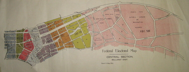 Federation University Historical Collection
Plan - Plans, Tulloch & King, Federal Electoral Map Subdivision of Ballarat, c1901
It is thought that these are the first federal electorial plans for the Subdivision of Ballarat. The first member of Ballarat was Alfred Deakin.May of the Federal subdivision of Ballarat, with each section depicted in a different colour. The plans include Lake Wendouree, Central Ballarat subdivision; Soldiers Hill subdivision; Ballarat East subdivision, and Central Section Ballarat East, including the Ballarat East Botanic Garden .ballarat, federation, alfred deakin, elections, plan, electoral division, electoral map, polling -
Federation University Historical Collection
Booklet, Federation University Strategic Plan, 2016-20, c2016
Federation University Australia was established on 1 January 2014. Formerly known as the University of Ballarat, its enabling legislation was the University of Ballarat Amendment (Federation University Australia) Act 2013. Although formally created as a University in 1994, the University of Ballarat has a lineage back to 1870 with the establishment of the School of Mines Ballarat, making it the third institution of higher learning to be established in Australia and the first to be established in regional Australia. On 1 January 1994, Ballarat University College became the University of Ballarat and in 1998 the University merged with three TAFE Institutes to become a dual sector institution with multiple campuses. On 1 January 2014, the University of Ballarat amalgamated with the Monash University Gippsland Campus to form Federation University Australia. The Gippsland Campus also had a long lineage dating back to 1928 with the establishment of the Yallourn Technical School which became a predecessor institution to the Gippsland College of Advanced Education formed in 1968. In 1990, it was renamed the Monash University College and in 1993 became the Gippsland Campus of Monash University. In 2016, Federation University Australia announced plans to take possession, over a two-year period, of Monash’s Berwick Campus in the south-east corridor of Melbourne. Federation University Australia, or FedUni, is headquartered in Ballarat and offers programs in Higher Education and Vocational Education and Training to regional Victoria and beyond. The University’s commitment to educational and social equity, teaching excellence, research distinction, environmental sustainability and regional capacity building has enabled it to develop in a way that draws on its proud heritage to inform its future. Its regional character sets a framework for the University’s priorities but does not constrain it from serving wider community interests, nationally and internationally. The name Federation University Australia was chosen to convey the scope and capacity of an expanded regional university with a federated network of campuses.A four year plan for the University of Ballaratfederation university, strategic plan, merger -
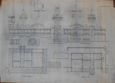 Bendigo Historical Society Inc.
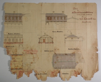
Plan - MARKS COLLECTION: PLAN OF FORTUNA VILLA
Copy of overall plan for Fortuna Villa. Plan shows entrance and garden elevations, ground plan and principal floor plan. Written on top of plan 'G Lansell Esq' 'Scale 8 feet to 1 inch'.bendigo, house, fortuna villa -
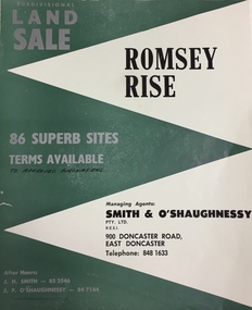 Kew Historical Society Inc
Plan - Subdivision Plan, Romsey Rise, Doncaster East
Real estate brochure for a land sale of 86 sites in East Doncaster. Roads identified in the plan include: George Street, Dennert Street, Worthing Avenue, Sandhurst Street, Belinda Crescent, and Romsey Rise.Historic subdivision plan of a Doncaster East EstateFour page colour real estate brochure including on page 2 a subdivision plan for the Romsey Rise estate in East Doncaster. This record also includes a separate price list for the lots.real estate plans, subdivision plans - doncaster east, romsey rise estate - doncaster east (vic) -
Port Melbourne Historical & Preservation Society
Plan - Immigration sculpture, Beacon Cove, Orchard Design Studio, Mark Weichart, 1998
Mirvac, Beacon Cove developers, commissioned this sculpture. Orchard Design Studio contacted PMH&PS for 19th Century migrant ship names, to be handcarved into jarrah portion of sculpture, and for approval of 20th century ship names for the steel section. In return we requested a copy of these plans.Presentation plans (two sheets) for sculpture at Beacon Cove, designed by Orchard Design Studio of Pakenham. One in full colour, one a photocopy only. Subject: immigration.Photocopy signed by the artist, Mark Weichart.piers and wharves - station pier, immigration, transport - shipping, arts and entertainment - visual arts, mark weichart, mirvac, sculpture, orchard design studio -
 Bendigo Historical Society Inc.
Plan - MARKS COLLECTION: FORTUNA PLANS
Copy of Plan: on top of plan 'Additions to Fortuna Villa for Geo Lansell Esq, scale 8 feet to one inch' Drawings of additions: ground plan, garden plan, second and third floor plan (mainly elevations).buildings, house, fortuna villa -
 Kew Historical Society Inc
Plan - Subdivision Plan, Mount Ida Estate, 1925
The Kew Historical Society collection includes almost 100 subdivision plans pertaining to suburbs of the City of Melbourne. Most of these are of Kew, Kew East or Studley Park, although a smaller number are plans of Camberwell, Deepdene, Balwyn and Hawthorn. It is believed that the majority of the plans were gifted to the Society by persons connected with the real estate firm - J. R. Mathers and McMillan, 136 Cotham Road, Kew. The Plans in the collection are rarely in pristine form, being working plans on which the agent would write notes and record lots sold and the prices of these. The subdivision plans are historically significant examples of the growth of urban Melbourne from the beginning of the 20th Century up until the 1980s. A number of the plans are double-sided and often include a photograph on the reverse. A number of the latter are by noted photographers such as J.E. Barnes.The Mount Ida Estate was a subdivision of fifty-two residential allotments bordering Tooronga Road, Leura Grove, Constance Street, and Mount Ida Avenue in Hawthorn East. The report of the sale of the Estate in The Argus (21 September) claimed that over 1,000 people attended the auction and that all allotments were sold on the day. On the other side of Constance Street, the plan identifies the ‘Eastern Recreation Reserve’ (now Anderson Park).subdivision plans - hawthorn -
Whitehorse Historical Society Inc.
Document, Joan Hornabrook
Life Governorship Certificate for Joan Hornabrook, from the Free Kindergarten Union of Victoria, 29 June 1978.Life Governorship Certificate for Joan Hornabrook, from the Free Kindergarten Union of Victoria, 29 June 1978. With letter from Meg Hornabrook outlining Joan Hornabrook's association with the Forest Hill Residential Kindergarten, and a plan of the Kindergarten's vegetable garden.Life Governorship Certificate for Joan Hornabrook, from the Free Kindergarten Union of Victoria, 29 June 1978. forest hill residential kindergarten, hornabrook, joan, free kindergarten union of victoria -
Clunes Museum
Document - REPORT, HEPBURN SHIRE, 2024
PLANNING POLICY PRINCIPLES WILL BE TAILORED TO RESPOND TO LANDSCAPE VARIATION AND DRIVERS OF LAND USE CHANGE AND THE DIFFERENTIAL IMPACT THAT THESE HAVE ACROSS THE SHIRE....1 RURAL HEPBURN - AGRICULTURAL LAND STUDY AND RURAL SETTLEMENT STRATEGY, UNBOUND REPORT PRINTED IN COLOUR ON PAPER, 94 PAGES .2 FUTURE HEPBURN - CLUNES STRUCTURE PLAN, UNBOUND REPORT PRINTED IN COLOUR ON PAPER, 67 PAGES ADOPTED BY HEPBURN SHIRE COUNCIL 3 SEPTEMBER 2024hepburn shire council, rural settlement strategy -
University of Melbourne, Burnley Campus Archives
Plan - Photocopy, Wendy Varcoe, Killamont, 1907? 1980?
Larger plan is probably of original fencing and drains from C.B. Luffman's layout. Killamont is the only known surviving private garden designed by Luffman.(1907).Photocopies of 2 hand drawn maps/plans of the garden at "Killamont." Drawn by Wendy Varcoe. Garden designed by C. B. Luffmann. (Also see B10.0040 Conservation Analysis and other C.B. Luffmann files in Box 75 A .)gardens, killamont, wendy varcoe, charles bogue luffman -
 Kew Historical Society Inc
Plan - Subdivision Plan, Camberwell Mountain View Estate, 1923
The Kew Historical Society collection includes almost 100 subdivision plans pertaining to suburbs of the City of Melbourne. Most of these are of Kew, Kew East or Studley Park, although a smaller number are plans of Camberwell, Deepdene, Balwyn and Hawthorn. It is believed that the majority of the plans were gifted to the Society by persons connected with the real estate firm - J. R. Mathers and McMillan, 136 Cotham Road, Kew. The Plans in the collection are rarely in pristine form, being working plans on which the agent would write notes and record lots sold and the prices of these. The subdivision plans are historically significant examples of the growth of urban Melbourne from the beginning of the 20th Century up until the 1980s. A number of the plans are double-sided and often include a photograph on the reverse. A number of the latter are by noted photographers such as J.E. Barnes.The so-called Camberwell Mountain View Estate was a subdivision on ‘the corner [of] Burke Road, Eyre and Wills Streets, Deepdene’. The Estate was not the first attempt to subdivide this land holding. In 1884, 1888 and 1894 the Belmore Park subdivision proposed 18 allotments for this parcel of land. The final stages of the Belmore Park subdivision occurred during the Depression of the 1890s. Apart from perhaps one block facing Burke Road, which is unnumbered in the Mountain View Estate subdivision, the rest must have remained unsold. The later subdivision would redraw the original 18 allotments, creating 22 new lots. In the Locality Plan on the left side of the subdivision plan, Deepdene Station, which formed part of the Outer Circle Railway is represented, as is the location of Deepdene Primary School. A selling point was the proposed extension of the Burke Road tram beyond its terminus at Cotham Road. The extension did not eventuate.subdivision plans - camberwell, mountain view estate -
 Federation University Historical Collection
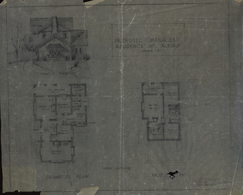
Plan, Proposed Manager's Residence at Albury
Two plans showing front elevation and layout plans.albury, architectural plans -
 Federation University Historical Collection
Plan, Plan (dyeline): Ballarat Girls' School Sewerage Plan, 1950
Plan (dyeline) for Ballarat Girls' School sewerage plan percy everett, ballarat girls' school, sewerage plans -
Lakes Entrance Historical Society
Book, Vantree Pty Ltd Shearwater Environmetal Management, East Gippsland - Creating a Community Heritage Plan, 2002
This plan provides for the long-term Coastal Action Planwaterways, environment, tourism, boats and boating -
 Bendigo Historical Society Inc.
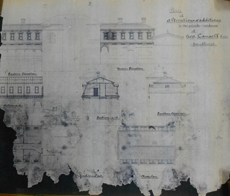
Plan - MARKS COLLECTION: PLAN OF ALTERATIONS AND ADDITIONS TO THE PRIVATE RESIDENCE OF GEO. LANSELL ESQR
Fortuna Villa was owned from 1855 to 1871 by Christopher and Theodore Ballerstedt, Australia’s first mining magnates. In 1871 it was purchased by George Lansell (The Quartz King) being one of Australia’s most successful and adventurous nineteenth century gold mine owners and speculators. Lansell made numerous alterations and extensions to the building. It remained in the Lansell family until 1935Plan for the alteration and additions to Fortuna Villaa, the private residence of George Lansell Plan shows southern, eastern & western elevations, floor and roof plan for the additions to the residence Coloured hand drawn construction plan Plan is undated plan has severe damage on LHS and bottom of the sheetfortuna villa, george lansell, building plans, c & t ballerstedt -
Port Melbourne Historical & Preservation Society
Booklet - Ministry for Planning and Environment, Urban Conservation Areas, Aug 1986
... Ministry for Planning and Environment ...Ministry for Planning and Environment booklet of Urban Conservation Areas August 1986, detailing in words and sketches areas of inner Melbourne of special significance historically and architecturally, to be preserved. 16 pp, brown ink on cream paper.built environment, garden city, town planning, victorian ministry for planning and environment -
 Federation University Historical Collection
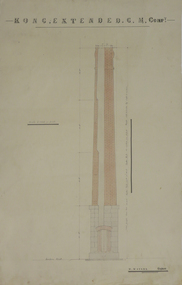
Plan, Kong Extended Gold Mining Company Chimney Plans, not dated
Two plans for a brick chimney with hand colouring .1) plan for brick chimney .2) plan for interior of chimneykong extended gold mining company, w. watson, plans for chimney, mining, architectural plans -
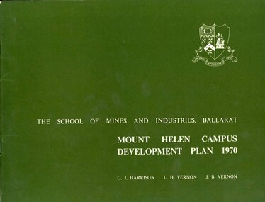 Federation University Historical Collection
Book, Mount Helen campus Development Plan 1970, 1970
Green and white soft covered booklet of 48 pages. SMB Crest is on the front cover. The content include the Mt Helen site, site planning, student residences, sporting facilities, roads and parking, pedestrian circulation, engineering services, and landscaping. Illustrations include: Plan of Mt Helen Site (July 1969, existing buildings, Functional relationship, Roads and Parking, Pedestrian Circulation, engineering Services, Landscaping, Development Plan, Plan of Academic area, Library and union Courtyards, Birds Eye View of Academic Area from north-west, etc. the master plan projects student numbers.non-fictionuniversity of ballarat, ballarat institute of advanced education, mount helen, master plan, landscape, harrison, vernon, great hall, geoff harrison, john vernon, m.b. john, contour map, student accomodation, landscaping, development plan, campus plan