Showing 3069 items matching "scales"
-
 Bendigo Historical Society Inc.
Document - BILL ASHMAN COLLECTION: CORRESPONDENCE
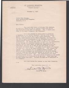
Three copies of a Letter, dated November 5, 1936, from Sister M. Monica to Sister Mary Gonzaga, relating to her the benefits of using scalebuoys in the water to the boilers and hot water systems. It had removed scale from the pipes. The only problem they had was the scale that had fallen off blocking the traps and that soon stopped. Scalebuoys were going to be installed in the cold water system as soon as there was more money to do it.Letterhead -St Josephs Hospital Phoenix Arizonasciences, instruments - general, scalebuoy, bill ashman collection - correspondence, st joseph's hospital arizona, sister mary gonzaga, mater misericordiae hospital auckland, mr herzog, st mary's hospital san francisco, mr abbott, sister mary monica -
 Bendigo Military Museum
Document - ADF Map and Air Chart Catalogue Part A, RASvy Corps, May 1991
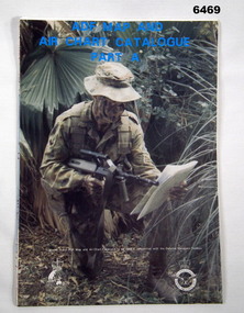
This document contains the "map and Air Chart Demand and Issue Voucher" to enable the ordering of map products. The catalogue of available products is shown on the reverse side to assist in the ordering process.1. A Map sheet of Australia folded to A4 in size. 2. A selection of map examples and a catalogue of products, Tactical Line Maps (TLM) at 1:50,000 scale to Digital Chart of the World (DCW) at 1:1,000,000 scale maps. The names of all the 1:100,000 maps are listed in alphabetical order. 3. The Map and Air Chart Demand and Issue Voucher is printed on the back of the document. 4. Front section has a photo of a soldier with a Steyr rifle kneeling reading a map.royal australian survey corps, rasvy, fortuna, army survey regiment, army svy regt, asr -
 Warrnambool and District Historical Society Inc.
Token, W Jamieson, 1862
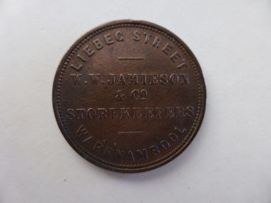
This is a token made for William Jamieson of Warrnambool in 1862. Tokens were coins made in the 19th century to alleviate the shortage of currency coins in Australia. They usually had a value of one penny and could only be used in the store or business designated on the coin. Two Warrnambool businesses had tokens made – those of William Jamieson and William Bateman Junior. Born in Scotland, William Wilson Jamieson completed an apprenticeship in the ironmongery trade in that country. He worked in the ironmongery business in Melbourne before establishing ironmongery stores in Koroit and Warrnambool (Liebig Street) in the late 1850s. He was a Warrnambool Councillor (1862 to 1874 & 1877 to 1880 and was Mayor (1866 to 1868 & 1872 to 1873). He was active in many local organizations, including the Warrnambool Hospital, the Fire Brigade, the Mechanics’ Institute, the Villiers Building Society the Caledonian Society and the Bowling Club. He died in 1882. This token is of great importance as it is an Australian token issued by W.W. Jamieson of Warrnambool in 1862 and so it is part of the fiscal history of Australia. It is also of great local significance as it comes from one of only two businesses in Warrnambool to issue tokens in the 19th century. It is today a rare token. This is a round metal coin (token) with, on one side, an image of a woman holding the scales of justice in one hand and a cornucopia in the other hand. This side of the coin has considerable staining. The other side has printing. Side One: ‘Australia 1862’ Side Two: ‘Liebeg Street W.W. Jamieson & Co. Storekeepers Warrnambool’ (N.B. Note the Warrnambool 1862 spelling of ‘Liebig Street’) william jamieson, australian tokens, history of warrnambool -
 Glenelg Shire Council Cultural Collection
Photograph - Photograph - aerial view of Portland coastline, c. 1954
Black and white aerial photograph of coastline around Portland. Black border, scale all sides, 5 rows of 3 't' at regular intervals. 10% ocean, 90% land. See 'Other Information'Front: '820- 52' - handwritten, white, border 'RUN 6' 'PORTLAND', printed, white, borderport of portland, aerial photography, south west coastline -
Glenelg Shire Council Cultural Collection
Photograph - Photograph - aerial view of Portland, c. 1954
Black and white aerial photograph of coastline around Portland. Black border, scale all sides, 5 rows of 3 't' at regular intervals. 25% ocean, 75% land. See 'Other Information'Front: '820 - 50' - handwritten, white, border 'RUN 6' 'PORTLAND', printed, white, borderaerial photography, central portland, portland harbour, south west coastline -
Glenelg Shire Council Cultural Collection
Photograph - Photograph - aerial view of Portland, c. 1954
Black and white aerial photograph of coastline around Portland. Black border, scale all sides, 5 rows of 3 't' at regular intervals. Mostly ocean, small area of land lower left.Front: '820-6' -- handwritten, white, lower border 'RUN 5' 'PORTLAND', printed, white, lower borderaerial photography, central portland, portland harbour, south west coastline -
Glenelg Shire Council Cultural Collection
Photograph - Photograph - Aerial photograph of coastline around Portland, Victoria, c. 1954
Black and white aerial photograph of coastline around Portland. Black border, scale all sides, 5 rows of 3 't' at regular intervals. Bottom 20% ocean, rest land, separated by beach.Front: '607 - 88' - handwritten, white, border 'RUN - 6 PORTLAND', printed, white, border -
Glenelg Shire Council Cultural Collection
Photograph - Photograph - aerial view of Portland, c. 1954
Black and white aerial photograph of coastline around Portland. Black border, scale all sides, 5 rows of 3 't' at regular intervals. Mostly ocean, small area of land, top left.Front: '607 - 49 ' - handwritten, white, border 'RUN 8' 'PORTLAND', printed, white, borderaerial photography, central portland, portland harbour, south west coastline -
Glenelg Shire Council Cultural Collection
Photograph - Photograph - aerial view of Portland, c. 1954
Black and white aerial photograph of coastline around Portland. Black border, scale all sides, 5 rows of 3 't' at regular intervals. Mostly ocean, small area of land, top centreFront: '607 - 50 ' - handwritten, white, border 'RUN 8' 'PORTLAND', printed, white, borderaerial photography, central portland, portland harbour, south west coastline -
Glenelg Shire Council Cultural Collection
Photograph - Photograph - aerial view of Portland, c. 1954
Black and white aerial photograph of coastline around Portland. Black border, scale all sides, 5 rows of 3 't' at regular intervals. Bottom third is ocean, the rest is land, separated by beach.Front: '607 - 89 ' - handwritten, white, border 'RUN - 6 PORTLAND', printed, white, borderaerial photography, central portland, portland harbour, south west coastline -
Glenelg Shire Council Cultural Collection
Photograph - Photograph - aerial view of Portland, c. 1954
Black and white aerial photograph of coastline around Portland. Black border, scale all sides, 5 rows of 3 't' at regular intervals. Bottom half ocean, top land, separated by beach.Front: '607 - 92 ' - handwritten, white, border 'RUN - 6 PORTLAND', printed, white, borderaerial photography, central portland, portland harbour, south west coastline -
Glenelg Shire Council Cultural Collection
Photograph - Photograph - aerial view of Portland, c. 1954
Black and white aerial photograph of coastline around Portland. Black border, scale all sides, 5 rows of 3 't' at regular intervals. Small strip of land across bottom. The rest is ocean.Front: '607 - 56 ' - handwritten, white, border 'RUN 7 PORTLAND', printed, white, borderaerial photography, central portland, portland harbour, south west coastline -
 Federation University Historical Collection
Plan, Scarsdale County of Grenville, 1889, 26/01/1889
Rectangular plan of a geological survey edged in masking tape. It is predominantly grey, pink and green, but has some yellow. scale is 40 chains to one inch. (see Cat. No. 1098 for report on the Parish of Scarsdale)scarsdale, grenville, krause, browns and scarsdale, mopianimum, watershed, yarrowee, woady yalloak, timber reserve, department of mines, plans, cgt, crown lands, ferdinand krause -
Glenelg Shire Council Cultural Collection
Photograph - Photograph - Model Breakwater, n.d
Port of Portland Authority Archivesport of portland archives, model breakwater -
Bendigo Historical Society Inc.
Map - CAMPBELL COLLECTION: BENDIGO & DISTRICT MAPS, 2-2-29
Map. Wellsford, Parishes of Wellsford and Axedale. Scale 20 chains to 1 inch. Total area 4994 acres. Prepared in W.P.B. from A. and P. Plans by W.J.G. (number 377 in map cupboard 1)W.J.Galbraithmap, bendigo, country lands -
Bendigo Historical Society Inc.
Photograph - FORTUNA COLLECITON: FORTUNA VILLA FRONT AND SIDE ELEVATION
Black line drawing of front and side elevation of Fortuna Villa. Possibly copied from Beebe's architectural drawings of Fortuna Villa. On bottom: front elevation, scale 4 feet to the Inch, side elevation'bendigo, house, fortuna villa -
 National Vietnam Veterans Museum (NVVM)
Model, M8A1 Cargo Carrier and 155mm field gun
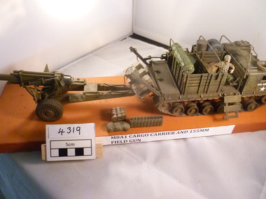
A scaled model of M8A1 Cargo Carrier and a 155mm Field Gun. The cargo carrier is towing the field gun. About to drop the gun and stores. One crew man in attendance. These models are on a sandy coloured plinth.US Army white starm8a1 cargo carrier, 155mm field gun, model -
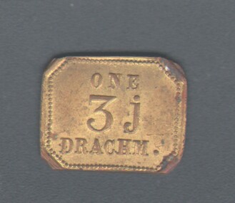 Bendigo Historical Society Inc.
Tool - WES HARRY COLLECTION: ONE DRACHM WEIGHT
Rectangular brass weight, one side has the words ' One 3J Drachm ' embossed, and the reverse ' 'W & T Avery, Limited, Birmingham '. This weight would have been used with a set of gold scales.mining, marketing, brass weight, gold scales, brass weight, one drachm -
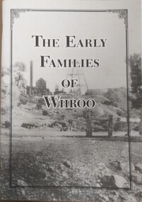 Tatura Irrigation & Wartime Camps Museum
Booklet, The Early Families of Whroo
Tells a short story of the early families who settled at Whroo, a gold mining area, located near Rushworth. The town is no long in existence. Written by Doris KIngA5 size booklet with soft cardboard cover. Cover has a black frame in from the edge with the book title in that in black print. Cover is a grey scale photograph of the Whroo mining site. 88 pages.titlewhroo, families of whroo, doris king -
Southern Sherbrooke Historical Society Inc.
Plan - Plans for Proposed Sports Pavillion and Scout Hall at Menzies Creek
Two copies of sketches for a proposed sports pavilion and Scout Hall at Menzies Creek, from multiple angles (front, side and rear). All sketches are at 1:100 scale. Includes floor plan of the building. -
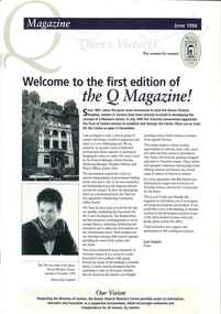 Queen Victoria Women's Centre
Newletter, Q Magazine: Welcome to the first edition of the Q Magazine!, June 1996
First edition of the Q MagazinePrinter paper. 8 pages. Navy and taupe on white. Grey scaled images throughout of women who are employed by the Trust or are sitting on the trust. Middle pages include original planned layout for the QVWC building. newsletters, historic buildings, cultural structures and establishments -
University of Melbourne, Burnley Campus Archives
Plan, Yarra 500/045.043 Municipalities of Prahran 211 and Richmond 207, 1979
Melbourne and Metropolitan Board of Works Series 1:500. Map prepared by the Survey Division, MMBW January 1979. Scale 1:500. Area surrounding Heyington Station and St. Kevin's Junior Schoolmelbourne and metropolitan board of works, prahran, richmond -
University of Melbourne, Burnley Campus Archives
Plan, SAB Surv(ey?), c. 1986
Copy with right side cut off so difficult to read. Plan of Student Amenity Building and surrounding area with legend. By Peter Ell(emans? Student in 1986) Subject: Engineering. Scale 1:100.students, amenities, burnley college of horticulture, student amenity building -
Glenelg Shire Council Cultural Collection
Plan - Plans / Line Drawings - Port of Portland Authority Trawling Vessel Sensation, Victoria, n.d
PORT OF PORTLAND AUTHORITYFront: '30' - black texta, top right corner -
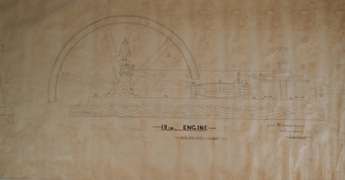 Bendigo Historical Society Inc.
Plan - HORWOOD COLLECTION: DRAWINGS FOR CONSTRUCTION OF 18'' ENGINE
Engineers plan for an 18 '' engine. Written on bottom 'J. Horwood and Sons, Engineers, Sandhurst. 18 IN Engine, Scale one inch = one foot' Plan drawn in fine black pen on waxed paper.bendigo, industry, horwood, foundry, mining equipment -
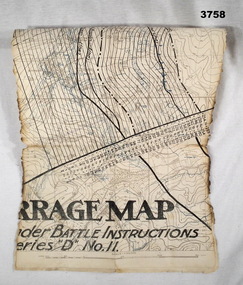 Bendigo Military Museum
Map - BARRAGE MAP, FRANCE WW1, Possibly 1918
Villeret is centred within the areas of Rosiel, Bony, Bellicourt and Bellenglise. The map is possibly when the advance was into the Hindenburg Line in late 1918. Item re William Alexander No 502 AIF. Refer Cat No 3746.3 for his service details.Map, small section of a “Barrage map” showing objective lines with distances, enemy trenches are in blue. Top half and bottom half of the map are missing. Area covered appears to be “Villeret” scale 1:20,000map, trench, barrage -
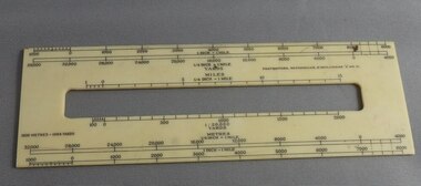 Greensborough Historical Society
Ruler, Scale rule for map reading, 1950c
Small rule to measure distance when reading a scale map. Measurements in yards or meters.Small plastic rule, cream colour with black markings.map reading, scale ruler -
Whitehorse Historical Society Inc.
Map, Melbourne and Metropolitan Board of Works, Feb 1982
Map area: North - Laburnum and Blackburn Stations East - Blackburn Lake South - bordering Canterbury Road West - Middleborough Roadnon-fictionMap area: North - Laburnum and Blackburn Stations East - Blackburn Lake South - bordering Canterbury Road West - Middleborough Roadmaps, melbourne and metropolitan board of works, parish of nunawading -
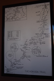 Wangaratta RSL Sub Branch
Map - Framed Map, Kokoda Trail
Map of the Kokoda Trail terrain to scale with approximate travel times depending on fitness and conditions.Black frame containing map of terrain in black on white paperThe Kokoda Trailkokoda, new guinea, ww2 -
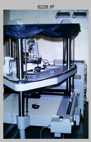 Bendigo Military Museum
Photograph - Orthorectification Equipment - Army Survey Regiment, Fortuna, Bendigo, c1975, c1988
Orthophoto mapping provided the Survey Corps with the capability to produce map products quickly in the event of a crisis. These are four photographs of equipment used by the Army Survey Regiment to produce orthophotomaps. The Wild GZ1 orthophoto projector shown in photo.1P was introduced in 1973 and was the first equipment used to orthorectify colour and monochrome film aerial photography. Height profiles were originally produced on a PEB8 Stereo profiler and later were software generated. Photos of the PEB8 are available in Victorian Collections item 6222.17P, photos .5P and .6P. In the same era the IBM 1130 computer; OMI/Nistri AP/C-3 analytical plotter with coordinatograph, OP/C orthophoto projector and Zeiss Planimat D2 stereoplotters were introduced. Orthorectification is the process of removing geometric distortions and scale errors/variations from images. Images have tilt and relief distortions that make it difficult to compare accurately a map and an image of the same geographic area. Once an image is orthorectified, features on the image are shown in their planimetric locations. The WILD OR1 orthophoto projector and workstation shown in photos .2P to.4P was introduced in the mid-1980s. It was the second-generation equipment used to orthorectify colour and monochrome film aerial photography, replacing the system introduced in 1973. See items 6124.5P and 6133.4P for more photographs of orthorectification equipment.These four photographs of orthorectification equipment were taken at the Army Survey Regiment at Fortuna, Bendigo, c1975 and c1988. The photos are on 35mm colour slides and scanned at 96 dpi. They are part of the Army Survey Regiment’s Collection. .1) - Photo, colour, c1975, Wild GZ1 orthophoto projector. .2) - Photo, colour, c1988, WILD OR-1 unrectified colour photo in carrier, orthorectified and re-scaled colour image. .3) & .4) - Photo, colour, c1988, WILD OR-1 Orthorectification Workstation.1P to .4P – Some of the equipment is annotated on the frame of the 35mm slides.royal australian survey corps, rasvy, army survey regiment, asr, army svy regt, fortuna