Showing 23604 items matching "15/7/2019"
-
 Eltham District Historical Society Inc
Photograph, Liz Pidgeon, Heritage Excursion; East of Eltham, 6 Sep 2014, 20 May 2017
Newsletter No. 218, September 2014 September Excursion - East of Eltham Walk In Newsletter No. 197, March 2011, there was a brief history of Crown Allotment 15 Section 5 Parish of Nillumbik (CA 15) a parcel of land of a quarter of a square mile extending from Eucalyptus Road to Reynolds Road at the eastern extremity of Eltham. From the 1940s it was known as Stokes orchard. In later years it has been subdivided for residential purposes but leaving significant areas as power line and water supply reserves and bushland reserves that are habitat for the threatened For our excursion on 6th September we intend to walk through CA 15 to a bushland reserve east of Reynolds Road. The walk will traverse the boundary between suburban Eltham and the non-urban areas to the south and east. This is a pleasant walk through residential areas and bushland. Along the way we will discuss the early and more recent history of CA 15 as well as local natural history and geology. This walk is about 3.5 km in length and will take 2 to 2.5 hours. It will start at 2pm at the corner of Eucalyptus Road, Pitt Street and Nyora Road.Born Digitaleltham east, eltham district historical society, heritage excursion, activities, nyora road, reynolds road, gum tree road reserve, diosma road, stokes orchard, eucalyptus road -
 Eltham District Historical Society Inc
Document, Certificate as to Trustees of Wesleyan Church land, Lot 20 Henry Street, Little Eltham North, 7 Oct 1901
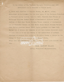
The Trustees for Lot 20 Henry Street were declared by the Wesleyan Methodist Church on 7 October 1901 to be Revd. Barnabas Shaw Walker, Minister of the Pentridge Circuit, Joseph Cooper, Gardener of Keelbundora, Samuel Jeffrey, Farmer of Jika Jika, Francis Thomas, Farmer of Doncaster and sometime of Keelbundora, John Brown, State School Teacher, William John Taylor, Gardener, Robert David Taylor, Gardener and Isaac Hill, Dealer, all of Eltham. Originally purchased in 1856 from Thomas Roberts, Yeoman of Little Eltham, for £10 for use by the Wesleyan Chapel, represented by indentured Trustees, Rev. Barnabas Shaw Walker, Minister of the Pentridge Circuit, Francis Thomas, Farmer of Keelbundora, William Harriman, Blacksmith of Nillumbik, Nicholas Rodda, Farmer of Nillumbik, Aaron Grimshaw, Farmer of Greensborough, Joseph Cooper, Gardener of Keelbundora, Peter Dredge, Scholmaster of Jika Jika and Samuel Jeffrey, Farmer of Jika Jika. Lot 20 of Subdivision of Portion 13, Section 4 of the Parish of Nillumbik in the County of Evelyn was located on the southern side of Henry street in Little Eltham North, where the current Our Lady Help of Christians Catholic Church is situated. It became the location of the Eltham Rechabite Hall. In 1893 a new hall was built and further enlarged in 1919. At the commencement of 1922, the property was purchased from the Independent Order of Rechabites with publicly subscribed funds and a new hall built at a cost of £750 and improved road access constructed to reduce the grade, running from Dudley Street to Henry Street. This hall was eventually replaced with the new Shire Offices and Hall built on the corner of Arthur Street and Main Road, which was opened in 1941. Traces the earliest history of the Eltham Public Hall in Henry Street and the various names, occupations and abodes of the Trustees associated with the propertyeltham public hall, eltham rechabite hall, eltham wesleyan chapel, francis thomas, henry street, james abel marsland, james massland, john brown, joseph cooper, little eltham north, rev barnabas shaw walker, robert david taylor, samuel jeffrey, trustee, william john taylor, little eltham, isaac hill -
 Bendigo Military Museum
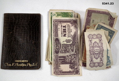
Container - LEATHER WALLET with Foreign Currency, Wallet with Foreign Currency
Currencies are issued by Japanese to three occupied territories, are as follows; 1. Philippine Peso - 2 notes. 2. Philippine Centavos - 2 notes. 3. Japanese Yen - 2 notes. 4. Hong Kong cents - 6 notes. 5. Indonesian Roepiah - 2 notes. 6. Indonesia (Dutch East Indies) Gulden - 7 notes. 7, Unknown - 50c note.Brown leather wallet - fold out. Various currencies of different denominations - issued by Japanese in WW2 in occupied countries.Embossed on front of wallet - "Compliments Chas. F. Hawkins Pty Ltd".wallet, foreign currency -
 Bendigo Military Museum
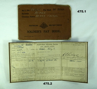
Financial record - PAY BOOKS, ADMINISTRATIVE, DOCUMENTS WW2, 1) 1941 - 1942 .2) 1915-1944 .3) 26.2.1941 .4)20.10.1944 ? .5) 10.3.1944? .6) 2.5.1942? .7)? .8) 30.4.1942 .9) 7.5.1942
Henry Thomas Ridge initially enlisted in September 1934 No V57996, 8th Australian Infantry Battalion CMF. He rose to Sergeant then qualified as a Lieutenant on 8.10.41. He was stationed in Darwin during the bombing 19th Feb 1941. He was discharged and the re enlisted as VX148845 AIF on 9.3.44. He served overseas and was discharged 29.7.46 in 8MD Papua. Refer 473P.1) Pay book No 257028, brown covers re H.T Ridge. .2) Drivers Licence No 214206, Army issue, brown fabric covers, folds in three re H.T. Ridge Lieut. .3) Drivers Licence No 592440,civilian, yellowish paper, red, blue, black writing re H.T. Ridge. Feb 29-1941. .4) Army "Final Statement account," form W.F.88 re VX149945 Ridge HT, 20.10.44. Paper, black and white, stamped 21 october 1944. .5) Typed note re Lieut H. Ridge, yellowed paper dated 10.3.44, red lettering at top of page " CUTSA New South Wales". .6) Letter, dated 2.5.1942 to Mrs E. Ridge re H. Ridge "Seriously ill with appendicectomy.", letter yellowed. .7) Cardboard , yellowed, typed and hand written re brief description V57996 and VX148845 H.T. Ridge, military and medical history. .8) Telegram Re " V57996 H.T. Ridge seriously ill 30th April." Double sided, front Blue with message, rear red, stamped 1 May 1942. .9) Telegram re " V57996 H.T Ridge removed from ill list 7th May 1942, double sided, front blue with message, rear red, stamped 18th may 1942. .10) Pay book No 195734, yellow covers re H.T Ridge.documents - licences / letters, communication - telegraphic, photography - photographs -
 Ballarat Tramway Museum
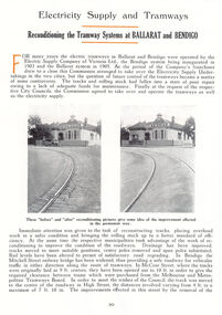
Document - Photocopy, M. Sayers, "Electricity Supply and Tramways / Reconditioning the Tramway Systems at Ballarat and Bendigo", 2000?
Photocopy of an article in the State Electricity Commission of Victoria Magazine, Contact, Vol 1, No. 4, Feb 1937 titled "Electricity Supply and Tramways / Reconditioning the Tramway Systems at Ballarat and Bendigo". Each item had a thin strip of paper attached by staple to the top left hand corner, giving the Vol. No. details. The item gives the background to the takeover from ESCo. Details some of the work undertaken in both Ballarat and Bendigo, including the widening of double track in McCrae St to 10' to allow ex MMTB trams to run. Work at Grenville St - City Loop, the method of track laying in Ballarat - concrete stringers, welded joints, financial arrangements for the work - employment council. Includes replacement of trolley wire. Features photos of reconditioned track on the Eaglehawk Route and a caterpillar tractor. Record revised 31/3/2019 to replace images with those from Andrew Cook CD and to include item .1 .1 - Item also was originally printed with different photographs in the Electrical Engineer and merchandiser Sept 15 1936. See Reg Item 2968i5.pdf. Copy provided on heat sensitive paper.trams, tramways, sec, reconstruction, trackwork, mccrae st, grenville st, esco -
 Eltham District Historical Society Inc
Photograph, Percy George Howard, c.1915, 1915c
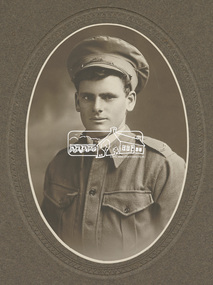
7 Howard family members went to the First World War and all came home. These included Herbert, Percy, GeorgeDigital file only - scanned by EDHS from item on loan [Mounted in embossed card 33 x 18 cm] aif, lew howard collection, ww1, first world war -
 Bendigo Military Museum
Memorabilia - CENTENARY of EAGLEHAWK ANZACS, FRAMED, Eaglehawk Heritage Society, DAVID J.V. JAMIESON, C2014
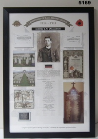
PRIVATE DAVID JAMES VICTOR JAMIESON No. 3875, 5th Infantry Battalion, killed in action 28/7/1916 in France.Memorabilia - framed story of a soldier in colour, using memorabilia of the soldier and his life, printed on paper. Frame - black extruded plastic, glass front, cardboard backing.DAVID J.V. JAMIESONframed item, anzacs, eaglehawk -
 Bendigo Military Museum
Legal record - ENVELOPE & WILL, 29th January 1944
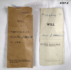
Kevin Joseph Harrison No 146838 RAAF, enlisted 27.1.1944, discharged on 18.2.1946 with the rank of LAC in No 7 Operational Training Unit. .1) Fawn coloured Official RAAF envelope form “RAAF P.P 77A”. .2) Hand written Will on Official RAAF form. The Will leaves all to his Mother Mary Harrison and appoints her as Executor. .1) On the front,” Will of No 146838, Rank A.C.I, name Kevin .J.Harrison, unit I.R.D” .2) On the front, “dated 29th of January 1944 Will of Kevin J Harrison”. Inside “Witnessed by .........266558 RAAF, J.E Campbell Sgt 57985 RAAF”will, envelopes, raaf