Showing 110288 items matching "roads"
-
 Warrnambool and District Historical Society Inc.
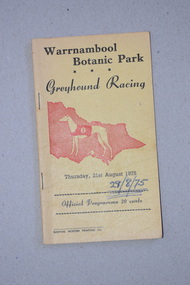
Programme, Gaspars Modern Printing Co, Greyhound Racing, 1975
This is a programme of a greyhound racing meeting held in Warrnambool in August 1975. The meeting was held in Botanic Park, in Botanic Road Warrnambool opposite the Warrnambool Botanic Gardens. Today greyhound racing meetings in Warrnambool are held in Koroit Street on a track in the Warrnambool Showgrounds and the Botanic Road site is now the location of a Catholic Primary School. This programme is retained as a memento of the 1970s when the Warrnambool Greyhound Racing Club meetings were held in a park in Botanic Road, Warrnambool. This is a soft cover booklet of 16 pages. The cover is yellow with black printing and an image in red of a greyhound and a map of Victoria. The programme has been stapled but the staples have been removed. The pages and front cover of the programme have been marked with black biro and red crayon.‘Warrnambool Botanic Park Greyhound Racing Thursday 21st August 1975’warrnambool greyhound racing, history of warrnambool -
 Greensborough Historical Society
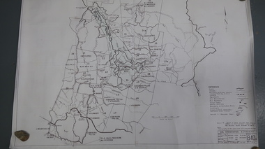
Map, Melbourne and Metropolitan Board of Works. Survey Division, MMBW, Yarra 2500 / 13.23. Plenty, Middle Gorge, 1978_04
Melbourne and Metropolitan Board of Works. Yarra 2500 [base map] 13-23. Plenty / Middle Gorge. Parish of Morang 3183. Municipalities of Diamond Valley 257 and Whittlesea 239. Prominent streets include: Gorge Road, Kurrak Road and Browns Lane. Features include the Plenty River and Plenty Gorge Park.MMBW Map in 1:2500 [scale] series. Cream parchment with green tape reinforcing on edges and punched holes on left edge.mmbw, melbourne and metropolitan board of works, shire of diamond valley, plenty - maps, plenty gorge park -
 Eltham District Historical Society Inc
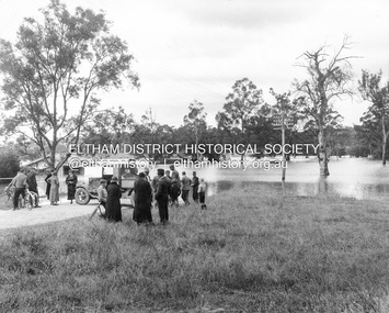
Photograph, Main Road, Eltham South, corner of Falkiner Street, flooded by the Diamond Creek, 1934
View of the Diamond Creek flooding across Main Road looking towards Eltham at intersection with Falkiner Street; a Council truck blocking Main Road, Eltham Lower Park on right, Eltham Park Tea Rooms (later Ansell and Muir) on left fooded. The bridge can just be seen on far right centre.Black and white photographmain road, eltham south, ansell and muir, diamond creek (creek), eltham park, eltham park tea room, falkiner street, floods, floodwater -
 Eltham District Historical Society Inc
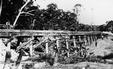
Photograph, Railway Bridge construction between Eltham and Hurstbridge, c.1912
The railway was extended from Eltham to Hurstbridge in 1912. This bridge is most likely near Allendale Road, Diamond Creek. It was one of four original trestle bridges in the stretch north of Allendale Road, which were all burnt out in January 1969 (replaced by two steel bridges and two corrugated iron culverts).This photo forms part of a collection of photographs gathered by the Shire of Eltham for their centenary project book,"Pioneers and Painters: 100 years of the Shire of Eltham" by Alan Marshall (1971). The collection of over 500 images is held in partnership between Eltham District Historical Society and Yarra Plenty Regional Library (Eltham Library) and is now formally known as the 'The Shire of Eltham Pioneers Photograph Collection.' It is significant in being the first community sourced collection representing the places and people of the Shire's first one hundred years.Digital image One 4 x 5 inch B&W negative One 9 x 12.5 cm printshire of eltham pioneers photograph collection, hurstbridge, allendale road, hurstbridge railway extension, railway bridge, railway line construction, trestle bridge, diamond creek (creek) -
 Whitehorse Historical Society Inc.
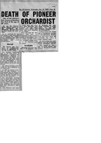
Article, Death of Pioneer Orchardist, 10/05/1967
Edward Henry (Harry) Pearce died in April 1967non-fictionEdward Henry (Harry) Pearce died in April 1967pearce harry, pearce edward h, springfield road blackburn no.106, blackburn high school, lend lease development, blackburn bowling club, woodhouse grove methodist church, old orchard shopping centre -
 Young Christian Workers (YCW Australia) Archive and Research Centre
Scrapbook of Road Safety Campaign newspaper clippings, Peter Cox, Journal Collins 4394, 1970-1973
Past YCW member Peter Cox created this scrapbook to document the reach the YCW Road Safety Campaign had in State wide newspapers from 1970-1973. The campaigned advocated for youth education and public enforcement on wearing of seatbelts, drink driving limits, Australia's drinking culture and decreasing the Victorian road toll.The road safety campaign undertaken by the YCW in the 1960-1970s was headed by Peter Cox.Rectangle bound book, with brown felt edging and blue leather middle. 200 pages, with 114 pages used for pasting various newspaper clippingsJournal Collins 4394the herald, scrapbook, ycw, bendigo, drinking, road safety, sandhurst, the sun, youth movements, the advocate, road toll -
 Sunbury Family History and Heritage Society Inc.
Photograph, Bulla P, 1988
The photograph was taken from the west side of Bulla Hill near Loemans Road, which is west of the township of Bulla. The rocks outlining the name of the town were a landmark when approaching the township along the Sunbury Road on the west side of the town. They remained there until the school was closed in 1996 and the new owner removed them.A coloured photograph of Bulla Primary School with the word 'Bulla' formed from rocks on the distant hillside. schools, bulla primary school -
 The Beechworth Burke Museum Research Collection
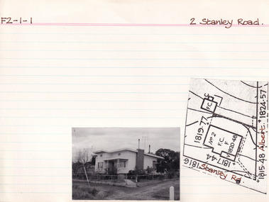
Card (Series) - Index Card, George Tibbits, 2 Stanley Road Beechworth, 1976
George Tibbits, University of Melbourne. Faculty of Architecture, Building and Town & Regional PlanningIndex system that support the research for Beechworth : historical reconstruction / [by] George Tibbits ... [et al]Arranged by street names of BeechworthEach index card includes: street name and number of property, image of property, allotment and section number, property owners and dates of ownership, description of the property according to rate records, property floor plan with dimensions.beechworth, george tibbitsbeechworth, george tibbits -
 Melbourne Tram Museum
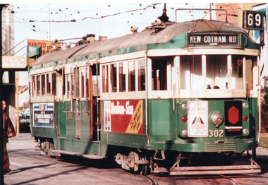
Photograph - Colour print, W2 302 - Glenferrie Road, 1970s
Image shows W2 class tram 302 (Route 69, Kew Cotham Road) possibly running out of the tram depot in Glenferrie Road. Tram has adverts for Royal Insurance, Rub-a-dub car wash, a beer bottle advert and an unreadable one. The tram was withdrawn and sold by the MMTB during 1979.Demonstrates a W2 class tram in service.Colour print on Kodak paper."Photo received 15/4/65"tramways, trams, w2 class, tram 302 -
 Melbourne Tram Museum
Document - Specification - set of 3 - Road Roller & equipment, Melbourne & Metropolitan Tramways Board (MMTB), mid 1950s
Three documents for the purchase of road pavement forming equipment 1 - "One (1) Road Roller (internal combustion Engined)" - 7 pages, undated 2 - "One mobile shovel and overhead loader" - five pages - undated 3 - :One(1) engine driven portable concrete mixer" - 9 pages - undatedYields information about the MMTB tender for road making equipmentSet of three documents - foolscap sheets stapled in top left hand corner and hole punched along the top edge.mmtb, tramways, contracts, purchases, trackwork, tools, road roller, loader, concrete -
 Greensborough Historical Society
Poster - Planning Document, Shire of Diamond Valley et al, Subdivision Plan # 1026 - Parish of Nillumbik, County Bourke, Crown Allotment B Section 12, Eltham North, 1981-1984
Subdivision Plan # 1026 - Parish of Nillumbik, County Bourke, Crown Allotment B Section 12, Eltham North. This subdivision plan includes Ryans Road (also known as Government Road) and St Clems Street. The developer for this subdivision is Taunton Developments and the Surveyors are Fisher Cleeland Turner & Dwyer Vic, Surveyors and Engineers.An example of hard copy subdivision plans from the Greensborough area. Mainly from the Shire of Diamond Valley era (1964-1994).Plan (single sided) mounted on heavy card. Stamped and handwritten Council permissions, dates and other details. subdivision plans, shire of diamond valley, taunton developments -
 Orbost & District Historical Society
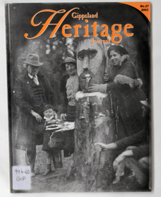
journals, Gippsland Heritage Journal, 2003
Gippsland Heritage Journal is a journal, produced about every nine - twelve months, for those interested in regional, local and family history in Gippsland, Victoria, Australia. It is compiled by Meredith Fletcher, Debbie Squires and Linda Barraclough and includes a diverse range of articles, both academic and non-academic. This issue has been edited by Meredith Fletcher.This item is a useful reference for the history of Gippsland.A 64 pp magazine, plastic covered, titled Gippsland Heritage Journal. The front cover is orange with a b/w photograph of Mr Stringy at Dead Horse Flat on the Omeo Road c 1937. The magazine contains photographs, articles on the history of Gippsland.On back - library barcode and price sticker - $13.20. On the front cover is a call no. 996.65 GIP journal-gippsland-heritage-journal history-gippsland mr-stringy-omeo -
Ringwood and District Historical Society
Document - Collection, Maroondah Women's Club Ephemera, 30-Oct-10
Collection of Business and Professional Women's Clubs of MaroondahCollection of approximately 30 papers, memos, member lists, constitution(1982), handbook of Maroondah and various other Melbourne and interstate clubs. There is one photograph of Irene Mascull, Pat Clark and Audrey Lavis, celebrating a birthday at 263 Canterbury Road, Heathmont. -
 Kiewa Valley Historical Society
Map - Bogong High Plains - Grazing Runs, Grazing Run Boundaries 1960 - Soil Conservation Authority
Cattle grazing on the Bogong High Plains during summer commenced in the 1840s and continued for many years. The Soil Conservation Authority recorded each family's area boundaries which were updated in June 1972 and continued to be adjusted until cattle were banned in 2005. The tradition of cattle grazing continues to be controversial.Holders of grazing rights for grazing on the Bogong High Plains were allocated specific areas recorded by the Soil Conservation Authority in 1972. Cattle have been banned in the Alpine National Park due to their impact on the environment.White paper with brown print. Bogong High Plains from Feathertop in the west to Mt Nelse in the east showing physical boundaries including the Kiewa Hydro Electric Scheme, roads, rivers and mountains. Names of families with grazing runs and the boundaries are shown.cattlemen, grazing runs, bogong high plains, kiewa valley families -
 Kiewa Valley Historical Society
Postcard Circa 1950, Snow Plough, Bogong High Plain,5,500 Feet Kiewa Hydro-Electric Project, Circa 1950
This postcard was produced in the 1950's for the tourist trade in the Kiewa Valley and Alpine region. It encompasses the period when the State of Victoria was pressured by the ever increasing demand by industry and its population for electricity supplies. Hydro electricity was seen as an untapped natural resource to quench this demand. The Victorian Alps and the rivers flowing into its valleys was ideal for the construction of the Kiewa Hydro Electricity Scheme. The late 1940's saw the development of this scheme and the changing of sections of alpine landscape is covered by this and other postcards/pictures (tourists, construction workers, and established rural populations). This period in time was before the established wildlife and forest/nature groups became political activist who changed legislative acts to protect the environment. This rural region (Kiewa Valley/alpine plains) was at most only significant to a smaller group of winter sports, summer hikers/horse riders and rural farmers/graziers. The numbers of tourists and the increase in the local resident population was boosted by the construction of the Hydro Electricity Scheme. This influx to the regional population resulted in a corresponding diversity in services and brought about an environment that responded to a growing level of tourists and thereby permitting this industry to grow more rapidly than it would have naturally. This postcard details an attraction to the "cleaner" method of providing electricity. This postcard was purchased in 1950 by a surveyor at Landford's Gap. This item is a black and white photograph(professional) of a panoramic view of a snow plough clearing the unsealed road in 1950.This postcard is on quality paper and the reproduction of the picture is of a high standard.For other "tourist" postcards see 0480 (A) -(F) for other photos of similar postcards. kiewa valley tourism, victorian alps, alternate energy supplies, alpine population growth, secv, snow plough -
 Phillip Island and District Historical Society Inc.
Photograph, 1960's
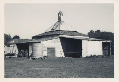
Donated by N. M. & J. D. Archibald. April, 1973Black & White Photograph. Chicory Kiln. Cowes - Mr. E. C. Wood, Settlement Road East. Built of mud 18" thick about 1880, by J. Jenner. Oldest Kiln still in operation as at April 1973. Chicory Kiln Album.local history, photography, photographs, agriculture buildings, historic, chicory kiln, cowes, phillip island, e c wood, j jenner, n & j archibald -
 Glenelg Shire Council Cultural Collection
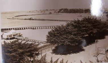
Postcard - Postcard - The Harbour, Portland, n.d
Black and white photographic image of a harbour with two long piers running into it and a shorter jetty with a building on it and circular jetty protruding from it. In the foreground are trees, a dirt road with an RACV sign bridging it to the foreground right and a railway track visible between the trees.Front: THE ROSE SERIES P. 10771/ COPYRIGHT (typed, lower left) THE HARBOUR, PORTLAND (typed, lower centre) -
Glenelg Shire Council Cultural Collection
Map - Map - RACV Road Map, 1970s
RACV road map, Warrnambool District, Port Fairy to Lorne. Large coloured map of Warrnambool District. Small maps of Apollo Bay, Colac, Camperdown, Tower Hill and Warrnambool. When folded, black and white photo on cover of 12 Apostlesracv, road touring, road map, victoria -
Glenelg Shire Council Cultural Collection
Photograph - Copy Of Photograph - Henty Wool Store, 1859
Vern Mc Callum CollectionDigital copy of a monochrome photo. Taken in Portland in 1859. Road in foreground, footpath with several men standing around. 3 two-storey blue stone buildings, with diffrent roof levels. Between building on left and middle buiding, is a horse and cart. -
Glenelg Shire Council Cultural Collection
Magazine - Magazine Article, Australian Off-Road Action, c. 1981
Pages 15 - 26 of 'Australian Off-Road Action' magazine. White, black print and photographs. Pages 16 -26 is an article title 'Portland - the venue' documenting the history of the Portland Dune Buggy Club from its formation inv 1969 -
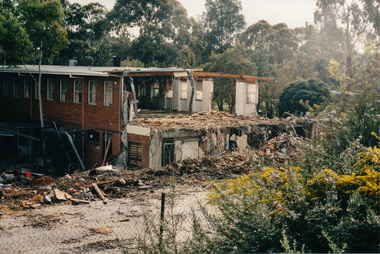
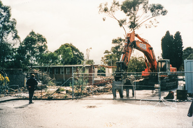
 Eltham District Historical Society Inc
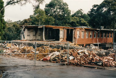
Photograph, Demolition of Eltham Shire Offices, 17 Aug 1996, 17/8/96
Three colour photographs of the Shire of Eltham Council Offices, Main Road, Eltham being demolished. 17 August, 1996. This followed Victorian Local Government re-amalgamations in 1994. This was a multi-story building which also included the Eltham Library.shire of eltham, demolition, buildings -
 Eltham District Historical Society Inc
Photograph, Demolition of Eltham Shire Offices, 17 Aug 1996, 17/8/96
Three colour photographs of the Shire of Eltham Council Offices, Main Road, Eltham being demolished. 17 August, 1996. This followed Victorian Local Government re-amalgamations in 1994. This was a multi-story building which also included the Eltham Library.shire of eltham, demolition, buildings -
 Ringwood and District Historical Society
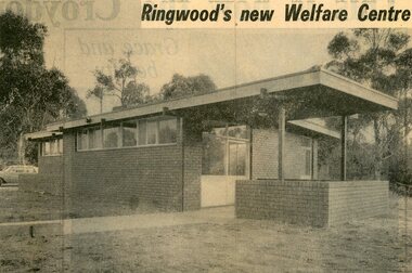
Newspaper, Packet- Ringwood Infant Welfare Centre clippings 1928 onwards
Packet includes the following: . 20 pages of newspaper clippings from 1928 onwards. (pdf) . Card listing minutes of Baby Health Centre from 1928 to 1943. (pdf) . Image of Infant Welfare Centre in Mines Road, Ringwood, 1967. (jpeg) -
 Bendigo Historical Society Inc.
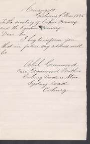
Document - COHN BROTHERS COLLECTION: 1895 HANDWRITTEN NOTE
Handwritten note from Athol Greenwood Care Greenwood Brothers, Coburg Produce Store, Sydney Road Coburg to The Secretary Cohns Brewery. Couangalt address. Beg to inform Cohns address will be Coburg Produce Store. Dated 9th March 1895bendigo, industry, cohn bros brewery -
 Bendigo Historical Society Inc.
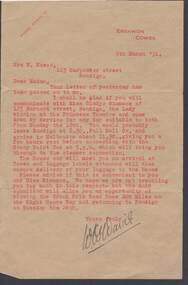
Document - W.D.MASON COLLECTION: LETTER, 5 March 1932
Document, W.D.Mason Collection, letter on brown paper with red typing dated 5.3.(19)31 from W.W.Davis at Erehwon, Cowes to Mrs. W.Mason, 123 Carpenter Street, Bendigo, concerning travel to Cowes.The Grand Prix Road Race is mentioned.W.W.Davisbusiness, retail, w d mason -
 Port Melbourne Historical & Preservation Society
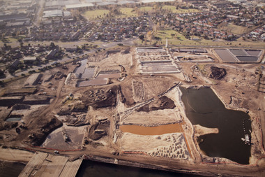
Photograph - Aerial view Beacon Cove area during soil cleaning operation, 1990
Framed colour aerial photograph of the Beacon Cove area during the soil cleaning operation prior to building the project. Area covered: from Beacon Road to Bain Street, and from the beach to the rear beacon. Foot of Princes Pier also shown.environmental issues -
 Bendigo Historical Society Inc.
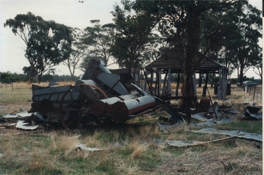
Photograph - ROY J MITCHELL COLLECTION: FARM MACHINERY NEAR SHED
Colour photograph of dilapidated farm machinery, standing near an open bay shed. Written on back:' 29.3.96 near Goornong Vict 14.30 hours, 14.30 hrs, Shepparton-Bendigo Road, near Goornong, Vic, by Roy J Mitchell, Bendigoagriculture, farm, machinery -
 Bendigo Historical Society Inc.
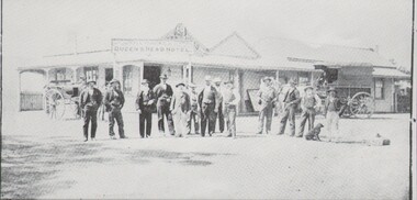
Photograph - HARRY BIGGS COLLECTION: QUEENS HEAD HOTEL,LOCKWOOD, C1905
Photograph (proof 45) of a group of men and a dog a standing outside the Queens Head Hotel, Lockwood Cross Roads,Lockwood. There is a buggy at the left rear of the group and a dray at the right rear. Above the hotel name can be seen 'H. Chadwick, Publican'buildings, hotel, queens head, queens head hotel, lockwood -
Whitehorse Historical Society Inc.
Article, The origin of L.L. Road, 1936
Article in Australian Home Beautiful, 1 May 1936 on the origin of L.L. Road, VermontArticle in Australian Home Beautiful, 1 May 1936 on the origin of L.L. Road, Vermont, challenging 'Suburban street names' by Richard Ross which says it ids named after Lewis Luxton, suggesting it is named after Dr L.L. Smith.Article in Australian Home Beautiful, 1 May 1936 on the origin of L.L. Road, Vermontstreet names, ross, richard, smith, l.l. (dr), luxton, lewis, l.l.vale road, vermont, boronia road, vermont