Showing 32386 items matching " building"
-
 Malmsbury Historical Society
Photograph (Item), Ww2 Remembrance Dinner, Malmsbury ca1995
Buildings - Town Hall People - "Rayner, Stella & Bill" -
Malmsbury Historical Society
Photograph (Item), "Town Hall Rememberance Dinner, Concert", Malmsbury ca1995
Buildings - Town Hall People - Malmsbury Primary School -
Malmsbury Historical Society
Photograph (Item), Daffodil Festival Display, Malmsbury ca 1989
Buildings - Town Hall People - "Slimmon, Bill & Richard" -
Malmsbury Historical Society
Photograph (Item), Memorabilia Display, Malmsbury ca1988
Buildings - Town Hall People - "Moody, Bill; Mangle, A" -
Malmsbury Historical Society
Photograph (Item), Display Of Rate & Receipt Books, Malmsbury ca1988
Buildings - Town Hall People - Nneta & Slimmon Families -
 Whitehorse Historical Society Inc.
Photograph, 24 McDowall Street, Mitcham, 13/06/2001 12:00:00 AM
Taken to mark change of ownership and change of use of building.Home of Arch & Eileen Kennedy and 6 children. Frank, second eldest son in photo, just prior to sale of house (Price $210,000) and conversion to dental clinic in 2000 (refer to eulogy for Arch) (ND1462).kennedy, arch, eileen, mcdowall street mitcham, no. 24 -
 Whitehorse Historical Society Inc.
Photograph, Mitcham Angling Club Headquarters, 13/06/1986 12:00:00 AM
Plans for this building were drawn by Ray Meagher, c1943.2 Coloured photos of Mitcham Angling Club Headquarters, West side Brittania Street, Mitcham. Originally located on Northern side of Guide Hall in small galvanised iron shed -(see NP1064) - now relocated in Brunswick Roadmitcham angling club, angler's club, meagher, ray -
 Ballarat Heritage Services
Photograph - Photograph - Colour, Former Homestead of William Rutledge at Port Fairy, 2017, 01/01/2017
In 2017 the building was used as the Port Fairy Youth Hostel.Photographs of a house in Port Fairy.Plaque "Emoli Original portion erected 1844 for merchant William Rutledge"william rutledge, port fairy, emoli, belfast, victoria -
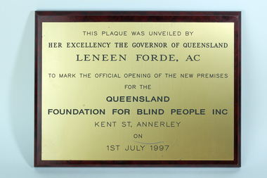 Vision Australia
Plaque - Image, Ace Trophies, Queensland Foundation for Blind People opening, 1997
Commemorative plaque for the opening of the Kent Street building in 1997.Wooden board with nameplate attachedThis plaque was unveiled by Her Excellency The Governor of Queensland Leneen Forde, AC to mark the official opening of the new premises for the Queensland Foundation for Blind People Inc Kent St, Annersley on 1st July 1997nameplates, queensland foundation for blind people -
 Port Fairy Historical Society Museum and Archives
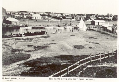
Postcard, The Rose Series / The Rose Stereographs, The Moyne River and Port Fairy, Victoria
River scene of the wharf and the buildings lining the street behind. Black and white photograph taken from Battery Hill looking across Moyne river at Merrijig Inn, Customs House and Courthouse The Rose Series P.1142 copyright- The Moyne River and Port Fairy Victoriastreet, town, moyne, river, couta boat, courthouse, merrijig -
 Heidelberg Golf Club
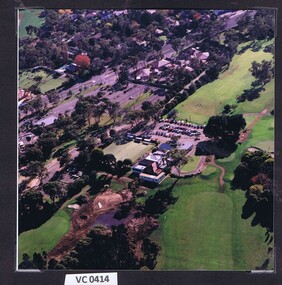
Photograph - Aerial Photograph, Heidelberg Golf Club 1998, 1998
Aerial view of the Heidelberg Golf Club course and buildings.Colour photograph.hgc clubhouse 1998, aerial photographs -
 Working Heritage Crown Land Collection
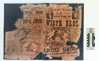
Pamphlet - Wirth Bros show pamphlets, May 18 1898
The pamphlet was found under the floorboards during works to the building Damaged and weathered pamphlets for a Circus and Show by the Wirth Bros Various text and illustrations depicting the activities of the show including horses, tigers and elephants and monkeys. 18th May 1898 historic newspaper, 1898, warracknabeal court house -
 Lakes Entrance Historical Society
Photograph - Kalimna Hotel, 1999c
Part of the original building burnt down May 1962.Colour photograph taken from the viewing platform looking back at Kalimna Hotel. Front veranda now built-in to create dining area. Lakes Entrance Victoria.hotels, restaurant -
 Lakes Entrance Historical Society
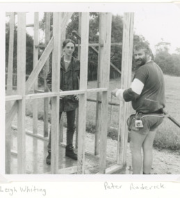
Photograph, Lakes Post Newspaper, Toorloo Arm Fire Brigade Gippsland Victoria, 1/01/1996 12:00:00 AM
building the new Fire Station at Toorloo Arm VictoriaBlack and white photograph of Leigh Whiting and Peter Roderick fire brigade -
 Kew Historical Society Inc
Plan, Melbourne & Metropolitan Board of Works : Borough of Kew : Detail Plan No.1569, 1905
The Melbourne and Metropolitan Board of Works (MMBW) plans were produced from the 1890s to the 1950s. They were crucial to the design and development of Melbourne's sewerage and drainage system. The plans, at a scale of 40 feet to 1 inch (1:480), provide a detailed historical record of Melbourne streetscapes and environmental features. Each plan covers one or two street blocks (roughly six streets), showing details of buildings, including garden layouts and ownership boundaries, and features such as laneways, drains, bridges, parks, municipal boundaries and other prominent landmarks as they existed at the time each plan was produced. (Source: State Library of Victoria)This plan forms part of a large group of MMBW plans and maps that was donated to the Society by the Mr Poulter, City Engineer of the City of Kew in 1989. Within this collection, thirty-five hand-coloured plans, backed with linen, are of statewide significance as they include annotations that provide details of construction materials used in buildings in the first decade of the 20th century as well as additional information about land ownership and usage. The copies in the Public Record Office Victoria and the State Library of Victoria are monochrome versions which do not denote building materials so that the maps in this collection are invaluable and unique tools for researchers and heritage consultants. A number of the plans are not held in the collection of the State Library of Victoria so they have the additional attribute of rarity.Original survey plan, issued by the MMBW to a contractor with responsibility for constructing sewers in the area identified on the plan within the Borough of Kew. The plan was at some stage hand-coloured, possibly by the contractor, but more likely by officers working in the Engineering Department of the Borough and later Town, then City of Kew. The hand-coloured sections of buildings on the plan were used to denote masonry or brick constructions (pink), weatherboard constructions (yellow), and public buildings (grey). This plan covers parts of Sackville Street, John Street, Thomas Street and Cotham Road, and includes several very large houses in Sackville Street. Job Smith built ‘Berrington’ in about 1888-90 for himself, and ‘Pomeroy’ (now ‘Merridale’) in 1885 for James Mickleburgh. ‘Heathfield’ was built in 1888 for Henry Eeles, and was one of many fine homes in Kew, Hawthorn and surrounding suburbs designed by prolific architect John Beswicke; it later became “La Verna” and was a Franciscan monastery. Similarly, in Cotham Road, we can see ‘Bella Vista’ (now demolished), and ‘Charleville’, with its double-storeyed arcade frontage, built in 1889 for Charles Donaldson whose family occupied it until 1939. This was renamed ‘Ross House’ by the second owner, Dr. Thomas King, and then substantially restored in the 1960s by the Stillwell family, well known as car drivers and dealers. Bella Vista (later ‘Malinda’) was originally designed by the architect Robert Haddon and built for Abel Hoadley, inventor of the Violet Crumble Bar and many other delicious delicacies. He began by manufacturing jams and pickles in South Melbourne using fruit from his own orchard in East Burwood.melbourne and metropolitan board of works, detail plans, mmbw 1569, cartography -
 Melbourne Tram Museum
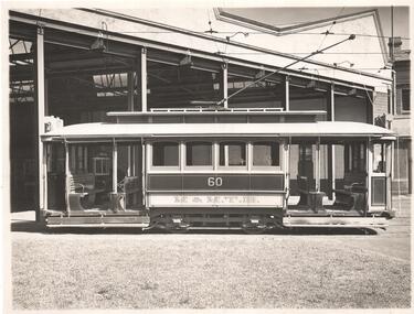
Photograph - Set of 2 - tram 60 Kew Depot, Sutcliffe Pty Ltd, c1920
Photographs of H class car 60 at the Kew Depot c1920's. .1 - Tram painted in MMTB chocolate and cream colour scheme. Side elevation photo with depot buildings in background. Taken prior to modification of roofs at end of cars to building in destination box. Tram of same class at SEC No. 18. Tram E45 can be seen in the shed. .2 - Front elevation photo with depot buildings in background. Has old style destination box on roof, showing "DEEPDENE" and a route number box above the headlight. Both photos Print and photograph by Sutcliffe of Cromwell buildings 366a Bourke St. Melbourne.Yields information about H class tram No. 60 and Kew DepotSet of two Photograph, Black and White, In ink on the rear: .1 - "M&MTB H-60, Kew Depot `1920's (E45 in shed)" and the photographers stamp. .2 - ditto. KSK print number SA938 and 939.trams, tramways, h class, kew depot, deepdene, e class, tram 60, tram 45 -
 Warrnambool and District Historical Society Inc.
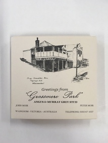
Souvenir, Coasters Grassmere Park x 11, Late 20th C
Grassmere Park is a property on the outskirts of Warrnambool at Wangoom. The scenes depicted are of historic buildings such as Star of the West in Port Fairy, the Koroit Post Office and various buildings at Flagstaff Hill in Warrnambool. The drawings are all signed by John Moir a local artist.Social significance. A common item with local views with which local people would be familiar.A set of 11 square cream card coasters with black pen drawings of local scenes with text underneath the drawings.Greetings from Grassmere Park Angus and Murray Grey Stud. John Moir Peter Moir. Wangoom Victoria Australia telephone 055)671037warrnambool, grassmere park, wangoom, -
![Newspaper Clipping, Diamond Valley Leader, Children to rule again [Bundoora Primary School Bu1915], 06/06/2018](/media/collectors/4f729f5697f83e03086015b8/items/5b2498bd21ea671284fc9bed/item-media/5eabe7ff21ea670ff440eca5/item-fit-380x285.jpg) Greensborough Historical Society
Greensborough Historical SocietyNewspaper Clipping, Diamond Valley Leader, Children to rule again [Bundoora Primary School Bu1915], 06/06/2018
The former Bundoora Primary School building has reopened as a kindergarten and childcare centre. The Greensborough Historical Society have been especially interested and have been kind enough to share original photos of the building and class photos from the 1930s.News article 1 page, black text and colour images.bundoora primary school, greensborough historical society, nino childcare bundoora -
 Port Melbourne Historical & Preservation Society
Photograph - Open Air Campaigners, Garden City Reserve, Reverend Donald LANGFORD, c.1970
An Open Air Campaigner entertains a group of children at Garden City reserve. Behind him, the inland ship navigation Beacon is on the left and the BO building to the right. This building was used for several years in the 1980's as the location for the Port Melbourne Library.B & W photograph of Garden City Reserve with Open Air Campaigner.built environment - industrial, built environment - recreational facilities, beacon, open air campaigners, port melbourne free library -
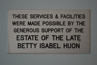 Vision Australia
Photograph - Image, Acknowledgement of supporters
As buildings were updated and additions made in line with changing needs of clients, plaques are often used to recognise and pay tribute to the benefactors that have enabled this to occur. These plaques were located in the Kooyong building and removed during its refurbishment in 2017.2 plaques acknowledging donors on wallThese services & facilities were made possible by the generous support of the estate of the late Betty Isabel Huon. These services & facilities were made possible by the generous support of the Percy Baxter Charitable Trust.betty isabel huon, percy baxter, fundraising, vision australia foundation -
Glenelg Shire Council Cultural Collection
Photograph - Photograph - Portland Harbour Trust - New store and workshop area 22/1/53, 1953
Port of Portland Authority archivesFront: NEW STORE BUILDING AND WORKSHOP AREA 22/1/53/ VIEW FROM CLIFF ST. BRIDGE (lower centre) Back: P.H.T./ Print No. 3/8 Neg. No 110/ Date taken 22.1.53./ SUBJECT./ % (Ink stamp with blue pen and pencil additions, centre)port of portland archives -
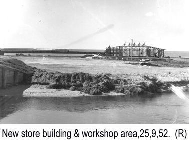 Glenelg Shire Council Cultural Collection
Photograph - Photograph - Portland Harbour Trust - New store and workshop area, 25.9.52, 1952
Port of Portland Authority archivesFront: NEW STORE BUILDING AND WORKSHOP AREA 25.9.52./ VIEW FROM CLIFF ST. BRIDGE (lower centre) Back: P.H.T./ Print No. 3/4 Neg. No 5/ Date taken 25-9-52/ SUBJECT./ % (Ink stamp with blue pen and pencil additions, centre)port of portland archives -
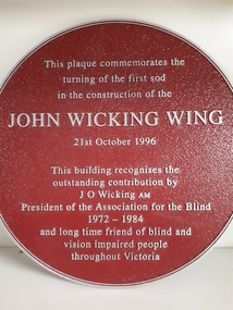 Vision Australia
Plaque - Object, John Wicking Wing, 1996
Constructed in 1996, the new wing at Elanora Nursing Home was named after John Wicking, President of the Association for the Blind for over 10 years, and a strong supporter of the Association and it's work.1 round metal plate with raised inscriptionThis plaque commemorates the turning of the first sod in the construction of the John Wicking Wing, 21st October 1996. This building recognises the outstanding contribution by J O Wicking AM President of the Association for the Blind 1972-1984 and long time friend of blind and vision impaired people throughout Victoria.association for the blind, john wicking, elanora home (brighton), nameplates -
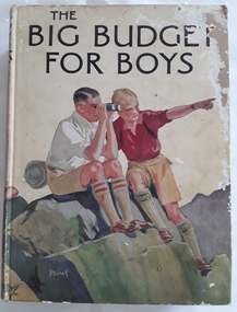 Mont De Lancey
Book, Blackie and Son Limited, The Big Budget for Boys, c1930's
Book read by family members, especially Lance Sebire who was awarded it from Sunday School in 1936Large hardcover children's book for boys with coloured picture on front cover of two boys sitting on a rock, one looking through binoculars and the other pointing into the distance. The title, The Big Budget for Boys is printed in black lettering on the front and spine with an illustration of another boy and the publisher. The back cover is also illustrated in colour with two more boys reading a map. The collection of adventure stories have black and white illustrations throughout.Mrs Les Gaudion's Class - Methodist Sabbath School Wandin Yallock. Awarded to Lance Sebire for Diligence and Attendance. Mr J H Lord Supt. Harold Blanksby Sec. May 18th 1936. The Book Depot, 288 Little Collins Street (Methodist Book Buildings)adventure, young people's fiction, children's fiction, children's book -
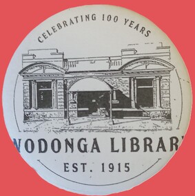 Wodonga & District Historical Society Inc
Badge - Wodonga Library 100 Years
W. Thorne architect of Albury designed the library building and the plan was approved in June 1915 The building contractor was J. W. Cochrane of Albury. The land was purchased from Mr. Walter Huon. On the 28th July 1915 the Shire President, Councillor Beardmore, laid the foundation stone for the building that would become the Wodonga Public Library. Almost 12 months later, on the 8th March 1916, the library was officially opened. It was the pride of Wodonga. The Shire Council closed their doors for a brief period so that all staff could attend the opening and the teachers and children of the local schools also attended. Councillor Beardmore declared that “it was an asset that would return a profit- not in pounds and shillings and pence but in the development and furnishing of the minds and lives of our young people”. It was known as the Beardmore Library. The Wodonga Athenaeum, in an out of the way location, had closed in 1914 after continuing reports of a lack of funds and the proceeds of the sale of the building went towards the building of the new library. In 1915 the library building committee started to put together a building fund for a new library. The library, situated at 78 High Street, was funded almost exclusively by the public. The books from the Athenaeum were presented to the library committee at the opening in 1916. The new library was both a place for education and recreation, a communal space to socialise, which also boasted a billiards room downstairs. In March 1970 construction of a new Civic Centre which included a library began in Wodonga. With its completion the following year, the original library was closed down. The building was vacant for some time and deteriorated badly. It was later purchased by Peter Middleton, who extensively restored the building. This badge is significant because it was produced to commemorate the centenary of an important Wodonga building.A metal and plastic badge featuring a sketch of the Wodonga Library as well as text.CELEBRATING 100 YEARS WODONGA LIBRARY EST. 1915wodonga library, wodonga buildings -
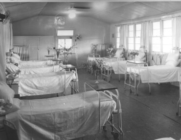 Kiewa Valley Historical Society
Photograph Tawonga Hospital, A ward at Tawonga Hospital, 1949/50
This photo is of a ward - probably the female ward, as there a many floral arrangements - of the original hospital at Tawonga. This was situated at the corner of Ryders Lane and Kiewa Valley Highway. The building was transported from Bonegilla where it was originally a part of the Bonegilla Military Hospital. The hospital was opened on 24th September, 1949 with a capacity of 12 beds, but was later increased to 35 beds by enclosing the verandahs on 3 sides of the building. 'Add ons' provided theatre, offices, stores and a nurses home. Construction was commenced by the Hospital and Charities Commission with considerable input from the S.E.C., providing the removal and re-erection of the building, the accommodation for nursing staff and carried all work necessary to make the building operational as a hospital. Up until this time the nearest hospital was at Yackandandah. The hospital remained on this site until 1961 when a larger, more suitable building was purchased in Mt. Beauty from the S.E.C.A photographic record of a typical open plan style ward in that era. There were no private rooms. There are portable screens stored at the end of the room to provide "privacy" at the bedside when needed. There is a fan on the wall for cooling. Depicts the rather primitive conditions of that era when compared with todays standards.Black and white photograph of a ward in the Tawonga District Hospitalhospital, ward, tawonga -
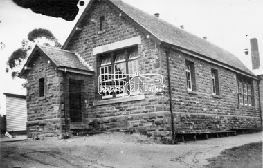 Eltham District Historical Society Inc
Photograph, Eltham State School No. 209, Dalton Street, Eltham, c.1918
Eltham Primary School. This building is the earliest building remaining on site today. It was built in 1875 and was the second school building replacing the original 1856 building of stone walls with wooden shingles on the roof. That building needed to be replaced after the stone walls collapsed outwards. In August 1912 the school issued a requisition for remodelling of the school concerned with replacement of the existing windows with larger and wider windows to allow additional light into the school rooms and the erection of a wooden partition in the centre of the room. This work commenced in early 1914 and this photo shows the altered windows. Pre 1921 extension and skylights in roof. Only two low wooden stairs present to enter the porch. These were rebuilt by 1928. A steel mud grate was introduced 1930s/1940s and an infant shelter shed is shown on the 1945 plan. Photo most likely taken between 1914 and 1921.This photo forms part of a collection of photographs gathered by the Shire of Eltham for their centenary project book,"Pioneers and Painters: 100 years of the Shire of Eltham" by Alan Marshall (1971). The collection of over 500 images is held in partnership between Eltham District Historical Society and Yarra Plenty Regional Library (Eltham Library) and is now formally known as the 'The Shire of Eltham Pioneers Photograph Collection.' It is significant in being the first community sourced collection representing the places and people of the Shire's first one hundred years.Digital image 4 x 5 inch B&W Negsepp, shire of eltham pioneers photograph collection, eltham, dalton street, state school no. 209, eltham primary school, eltham state school, schools -
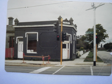 Glen Eira Historical Society
Photograph - Balaclava Road, Caulfield North
Two items about this addrress: 1/A photograph of the building on the north west corner of Balaclava and Kambrook Road, Caulfield North, dated 11/1980. The reverse of the photograph reads - Building on corner of Balaclava and Kambrook Roads, Caulfield 1887, NW Corner, November 1980. Photographer unknown. 2/File note of 25/02/2021 stating address is actually 23 Kambrook Road for this site although the building pictured is no longer standing.balaclava road, kambrook road, caulfield north, streetscapes, shops -
 Kiewa Valley Historical Society
Photograph of Clover Power Station, No. 3 Power Station, after May 1944
In July, 1941 work commenced on the site of the power station with the building of a coffer dam and excavation for the power station building and machine foundations followed. Work proceeded, and the access bridge, transformer foundations and transfer track were completed in April, 1943 and the power station building in May, 1943. Installation of the machines was then proceeded with and No. 1 machine was run for the first time in June 1944. No. 2 machine was completed in April, 1944 and placed in service in May.A pictorial record for the State Electricity Commission of the first Power Station commissioned in the Kiewa Hydro Electric Scheme.Black and white photograph of the bridge and entrance to No. 3 Power Station (Clover Power Station).Handwritten on back of photograph in blue ink "No. 3 Power Station".clover, power station, machine, kiewa scheme -
 Federation University Historical Collection
Photograph - Photograph (black & White), Ballarat School of Mines from Albert Street, c1936
The Ballarat School of Mines was the first of its type in Australia. The Albert Street frontage was the 'working end' of the campus with the mining laboratory, gauge tower and caretakers cottage. All the structures in the foreground have been demolished to make way for the Flecknoe Building and the M.B. John Building. Harry Brew, the well known Ballarat School of Mines caretaker, lived in the small weatherboard building to the right of the photograph. He was appointed to the staff at the Ballarat School of Mines in 1936.Black and white photograph showing the Ballarat School of Mines from Albert Street. Henry Richards Caselli's Gauge Tower is in the foreground. To its left is the Mining Laboratory, and to it's right is the caretakers cottage.verso 'SMB. Albert St frontage, showing (Harry Brew's) edge of his cottage. harry was a likeable character in his day, he was an old sailor boy, served, on HMAS Physice, & was an expert in , bugs and such like, crawling beasties (signature undecipherable)ballarat school of mines mining laboratory, caretaker's cottage, harry brew, henry caselli, hr caselli henry richards caselli