Showing 1550 items matching " aerial photographs"
-
 Glenelg Shire Council Cultural Collection
Photograph - Photograph - Portland Harbour, c. 1950
Port of Portland Authority Archivesport of portland archives, portland harbour -
Glenelg Shire Council Cultural Collection
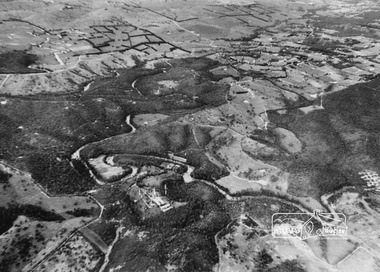
Photograph - Photograph - aerial view of Glenelg River, n.d
... Photograph - aerial view of Glenelg River... from air. Photograph Photograph - aerial view of Glenelg River ...Coloured photograph of Glenelg River from air.aerial photography, glenelg shire, glenelg river -
 Eltham District Historical Society Inc
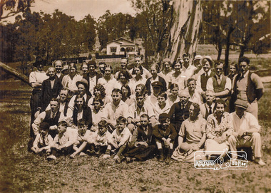
Photograph, Group from Brunswick ANA Lodge at Eltham, Nov. 1933
One of three photos. Group of people including children associated with the Australian Natives Association at an outing at Eltham Lower Park. The first image was reproduced in EDHS Newsletter No. 163 July 2005 following a query from Nillumbik Historical society (Gwen Myers) seeking information about the location of the photo. It was suggested that it may be Eltham Lower Park, however the house in the background did not appear correct. There were simliar but mirror imaged. A more recent review of these photographs (2023) suggests that the photos were actually taken in Bremners flats (present-day Wingrove Park) looking towards the house near the intersection of Main and Mount Pleasant roads - Mrs Bremner's house. The topograpghy is also more in fitting with this location than that of Eltham Lower Park. A review of a 1945 aerial photo shows only one house of similar style present in this location. Further reviews of photos taken in the 1950s by Grace Mitchell looking back towards Bremner Flats shows two trees close by on a lean similar to that in the photos.Inkjet-printed copy of sepia photographaustralian natives association, bremners flats, recruitment, wingrove park -
 Eltham District Historical Society Inc
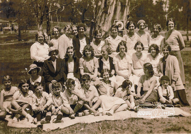
Photograph, Group from Brunswick ANA Lodge at Eltham, Nov. 1933
One of three photos. Group of people including children associated with the Australian Natives Association at an outing at Eltham Lower Park. The first image was reproduced in EDHS Newsletter No. 163 July 2005 following a query from Nillumbik Historical society (Gwen Myers) seeking information about the location of the photo. It was suggested that it may be Eltham Lower Park, however the house in the background did not appear correct. There were simliar but mirror imaged. A more recent review of these photographs (2023) suggests that the photos were actually taken in Bremners flats (present-day Wingrove Park) looking towards the house near the intersection of Main and Mount Pleasant roads - Mrs Bremner's house. The topograpghy is also more in fitting with this location than that of Eltham Lower Park. A review of a 1945 aerial photo shows only one house of similar style present in this location. Further reviews of photos taken in the 1950s ny Grace Mitchell looking back towards Bremner Flats shows two trees close by on a lean similar to that in the photos.Inkjet-printed copy of sepia photographaustralian natives association, bremners flats, recruitment, wingrove park -
 Eltham District Historical Society Inc
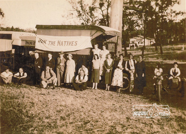
Photograph, Group from Brunswick ANA Lodge at Eltham, Nov. 1933
One of three photos. Group of people including children associated with the Australian Natives Association at an outing at Eltham. A truck displays a flag "Join the Natives". The first image was reproduced in EDHS Newsletter No. 163 July 2005 following a query from Nillumbik Historical society (Gwen Myers) seeking information about the location of the photo. It was suggested that it may be Eltham Lower Park, however the house in the background did not appear correct. There were simliar but mirror imaged. A more recent review of these photographs (2023) suggests that the photos were actually taken in Bremners flats (present-day Wingrove Park) looking towards the house near the intersection of Main and Mount Pleasant roads - Mrs Bremner's house. The topograpghy is also more in fitting with this location than that of Eltham Lower Park. A review of a 1945 aerial photo shows only one house of similar style present in this location. Further reviews of photos taken in the 1950s ny Grace Mitchell looking back towards Bremner Flats shows two trees close by on a lean similar to that in the photos. Inkjet-printed copy of sepia photographaustralian natives association, recruitment, bremners flats, wingrove park -
4th/19th Prince of Wales's Light Horse Regiment Unit History Room
Aerial Photograph, British Army, Mericourt, 31/7/18
... Aerial Photograph ... Aerial Photograph British Army ...An aeriall photograph taken from 5000 feet looking towards Mericourt from behind the British front. Marked on the photo is the approximate British front line as at 31-7-18, and, locations such as Chuignolles, St Germain Wood, Mericourt, Prayart, Somme, Cerisy. 3.B.S.48 Ht 5000 ftsomme, ww1, photo -
 Kiewa Valley Historical Society
Maps 3D - National Parks
Used by the employees of National Parks. The maps show the topography and contours in 3D when used with the stereoscope KVHS 0743. This enables the photographed area to be compared to previous photos and enables the planning of construction of eg. new roads etc. Digital information is now available.These photographs give the topography and contours of vast local areas eg. Mt Feathertop and Tawonga township.when used with a stereoscope. Black and white large aerial photos of the Bogong High Plains area. 14 to 20 of them all on thick paper and the same size as the brown wooden box which holds them. The box hasn't got a lid at the top.Identified and catalogued by National Parksmaps showing topography, national parks, stereoscope -
 Eltham District Historical Society Inc
Photograph, Aerial view of Yarra River near Kangaroo Ground - Bend of Islands area
Sepia aerial view of Yarra river at Bend of Islands; Henley Road on left in foregroundbend of isles, kangaroo ground, yarra river, henley road -
 Eltham District Historical Society Inc
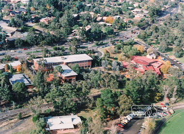
Photograph, Aerial view of Eltham Shire Office and Eltham Library precinct, 1994, 1994
... aerial photograph...Colour photograph of oblique aerial view centred on Eltham... photograph Colour photograph of oblique aerial view centred on Eltham ...Colour photograph of oblique aerial view centred on Eltham Shire Offices, 1994eltham shire office, eltham library, main road, eltham, aerial photograph -
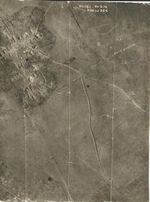
 Warrnambool RSL Sub Branch
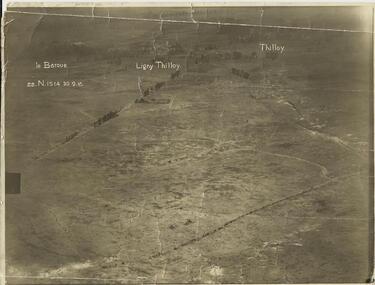
AERIAL PHOTOGRAPH, (Oblique shot of battlefield) 30/9/1916, LE BARQUE...... LIGNY THILLOY....... THILLOY, 22.N.1514
... AERIAL PHOTOGRAPH, (Oblique shot of battlefield) 30/9/1916... was repatriated. Snape Collection Sepia photograph, showing trench lines ...Original Item recovered from possibly Australian Corps HQ, probably between the Armistice, 11 November 1918, and June 1919, when the Staff Sergeant R.O.(Bob) Snape was repatriated.Sepia photograph, showing trench lines, gun emplacements, landscape peppered with shell craters.snape collection -
 Warrnambool RSL Sub Branch
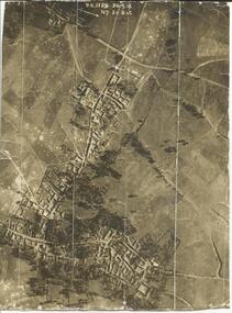
AERIAL PHOTOGRAPH, (Vertical shot of battle field, shelled/bombed out village) 30/9/1916, 3.C.1159, N7. 20.B &C
... AERIAL PHOTOGRAPH, (Vertical shot of battle field, shelled... AERIAL PHOTOGRAPH, (Vertical shot of battle field, shelled/bombed ...Original Item recovered from possibly Australian Corps HQ, probably between the Armistice, 11 November 1918, and June 1919, when the Staff Sergeant R.O.(Bob) Snape was repatriated.Sepia photograph showing shelled/bombed out village with all roofs blown in.snape collection -
 Warrnambool RSL Sub Branch
AERIAL PHOTOGRAPH, (Oblique shot of battle field, with shelled/bombed out vilage) 30/9/1916, 3.C.1151, N.26. 6d. 25d
... AERIAL PHOTOGRAPH, (Oblique shot of battle field, with... was repatriated. Snape Collection 3.C.1151, N.26. 6d. 25d AERIAL ...Original Item recovered from possibly Australian Corps HQ, probably between the Armistice, 11 November 1918, and June 1919, when the Staff Sergeant R.O.(Bob) Snape was repatriated.snape collection -
 Warrnambool RSL Sub Branch
AERIAL PHOTOGRAPH: 22.N.1559, Bapaume - Bancourt, Thilloy - Ligny Thilloy
... AERIAL PHOTOGRAPH: 22.N.1559, Bapaume - Bancourt, Thilloy... Warrnambool great-ocean-road Snape Collection AERIAL PHOTOGRAPH: 22.N ...snape collection -
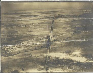 Warrnambool RSL Sub Branch
AERIAL PHOTOGRAPH, (Oblique shot of battlefield from Butte de Warlencourt, wrecked tank featured) 16/10/1916
... AERIAL PHOTOGRAPH, (Oblique shot of battlefield from Butte... Warrnambool great-ocean-road Snape Collection AERIAL PHOTOGRAPH ...snape collection -
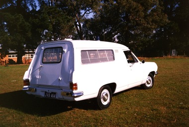 Victoria Police Museum
Photograph (police car)
Rear view of a 1967 Holden Divisional Van, registration number JVB-464, with a blue light on the roof and visible aerial. The van windows have visible reinforcement with a turn handle on the rear door. The background of the photograph has large trees and a single level brick building. There is no visible insignia on the car. Circa 1991police vehicles; motor transport branch; motor transport section; wireless patrol; holden van -
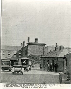 Victoria Police Museum
Photograph (police car), 1925
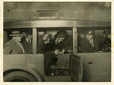
From a newspaper article showing the Russell Street yard with a number of vehicles and a group of five men standing around. Caption tells about the new aerial erected at police headquarters. The building shown are: single members quarters at the rear adjacent to LaTrobe St. Motor police offices on the corner with a vine covering the wall. The Wireless Room on the right adjacent to Russell St.Russell St Yard 1925police vehicles; wireless patrol; motor police branch; russell street headquarters; transport -
 Victoria Police Museum
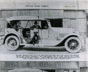
Photograph (police car), 04/03/1923
Wireless patrol car which is a Lancia Trikappa Tourer. The 7-stage amplifier with the tuning condenser can be seen through the open door of the car. Police dog on the running board. Photograph appeared in Popular Radio Weekly, March 4, 1923. The transmitter aerial was strung between the front and rear mudguards and lenghened by the driver raising the pole in order to improve reception. The receiver aerial is tied to the underneath of the roof.police vehicles; lancia trikappa tourer; motor police branch; wireless patrol; transport -
 Victoria Police Museum
Photograph (police car), Kodak
Wireless Patrol Daimler, with wireless transmitter and receiver visible on back seat. Senior Constable Bill Black front left seat, Operator Cliff Allison, circa 1927. Wireless aerial in tubing attached to roof.police vehicles; transport; motor police branch; daimler car; wireless patrol; allison, cliff; black, bill -
 Victoria Police Museum
Photograph (police car), Kodak
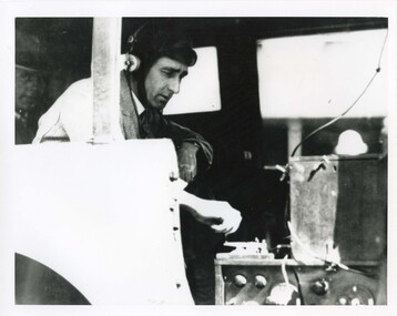
Possibly Rupert Bastin 6866, operating a wireless transmitter on the rear floor of a Wireless Patrol Daimler. The transmitter sits on top of the receiver. The wire leading up and to the right connects with the aerial. A wireless operator, possibly Rupert Bastin, and equipment. Circa 1926-1936motor police branch; wireless patrol; wireless operator -
 Victoria Police Museum
Photograph (police car), Kodak
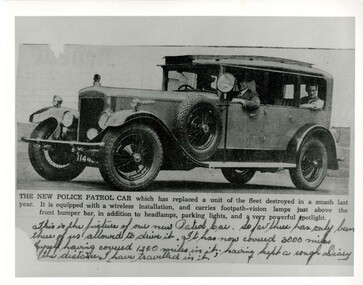
Copy of newspaper clipping of new Daimler patrol car with unidentified driver and two passengers, registration number 114 427, circa 1931. This was the last 35HP 6 cylinder version purchased. Photo shows spot light, aerial tubing on roof, Police sign, and sideways facing front spot lightspolice vehicles; transport; motor police branch; daimler car; wireless patrol -
 Victoria Police Museum
Photograph (police car), Kodak
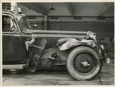
... the wireless aerials. Photograph (police car) Kodak ...Close-up photograph of 4.3 litre 6 cylinder Alvis Wireless Patrol car registration number 174-614 at Russell Street garage with significant damage to the front right hand wheel arch, circa 1937. Over the windscreen is the illuminated "Police" sign and on the roof are metals tubes containing the wireless aerials.police vehicles; transport; motor police branch; alvis car; wireless patrol; russell street -
 Victoria Police Museum
Photograph (police car), Kodak
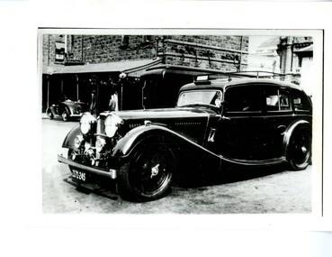
... . The "Police" sign and tubing containing wireless aerials can be seen ...Alvis Wireless Patrol car registration number 171-245, circa 1937 taken in the Russell Street HQ yard. The "Police" sign and tubing containing wireless aerials can be seen.police vehicles; transport; motor police branch; alvis car; wireless patrol -
 Victoria Police Museum
Photograph (police car), Kodak
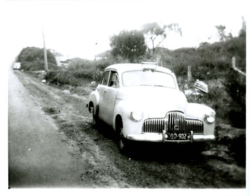
... . Note "Police" sign over windscreen and radio aerial at rear ...Holden Mobile Traffic Section patrol car, registration number OD-902, circa 1951. Note "Police" sign over windscreen and radio aerial at rear. police vehicles; transport branch; wireless patrol; motor police branch; motor traffic section; holden car -
 Victoria Police Museum
Photograph (police motorcycle)
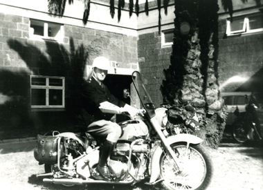
Dick Askwith, wearing full uniform including helmet, tunic, elbow length gloves, jodphurs and riding boots, astride an Aerial motorcycle with a large palm tree in the background. Circa 1960police vehicles; wireless patrol; motor transport branch; motor transport section; police motorcycles; ariel motorcycle; askwith, richard -
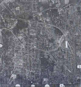 Ringwood and District Historical Society
Photograph, Aerial photograph of Heathmont, Victoria - c.1960s, 1975
... Aerial photograph of Heathmont, Victoria - c.1960s..... Aerial view of Heathmont - black and white photograph ...Aerial view of Heathmont - black and white photograph on chipboard backing. (Protected by slightly damaged plastic cover which could be removed for clearer image.)Department of Crown Lands and Survey Melbourne, Project Run 31A 27-12-1975, Lens 209 1951M ASL. -
 Ringwood and District Historical Society
Photograph, Photos of last houses to face demolition at Camberwell. c1970s, c1983
One of the last houses to face demolition.Single fronted weatherboard with striped veranda blind, brick chimney over front rooms with TV aerial. Green painted walls. Red painted iron roof over veranda and under veranda rail. Adjacent to Target entrance.The 'Miss Stayput' house in the car park out the front of Target in Camberwell. You can even see the Target logo on the building. The house was owned by Mary Campigli, who defied the council order to move, and won her case in court. She stayed in the house, surrounded by a car park until she died in 1983 at the age of 94. The house was finally demolished soon after. -
 Ringwood and District Historical Society
Photograph, Aerial view taken from slide - Ringwood Lake and surrounds 1969
Written on plastic sleeve, "Aerial view taken from slide - Ringwood Lake 7/8/69". -
 Orbost & District Historical Society
black and white photographs, 1980s? (winter months)
... Orbost-township-1980s aerial-photograph-Orbost... towards Bete Bolong. These photographs are detailed pictorial ...All photographs seem to have been takenfrom the Telecom tower on the corner of Browning and Wolseley Streets in Orbost 3259.1 is a view of the Orbost township looking north-east. The swimming pool and bowling club can be seen in the foreground. 3259.2 is aview looking north-west and showing the tennis courts and clubhouse, the Recreation Reserve oval, the Youth Centre, Historical Museum, Municipal Offices, Senior Citizens clubrooms with the fire station in the foreground. 3259.3 is a view looking south with the Shire of Orbost Municipal offices and Ruskin Street in the foreground. Munro Street can be seen running from Ruskin Street to St Joseph's School in the middle distance. Lochiel Park oval, Lochiel House, the Snowy River and highway bridge are in the background. 3259.4 is a view looking south showing the Club Hotel, C.B.C. Bank in the middle distance and Hoffman's paddock (Forest Park) and the Snowy River beyond. 3259.5 is a view looking north-east over houses. 3259.6 is aview over the main street, Nicholson Street.showing the main shopping precinct. Shop signs for Permewans, Williams Shoes, F.B. Dicken and Orbost Bakery can be seen. 3259.7 is a view looking south west and shows Forest park and beyond towards Bete Bolong.These photographs are detailed pictorial records of the township of Orbost.Seven black / white photographs taken from above a township. Chimney smoke can be seen in the photographs.orbost-township-1980s aerial-photograph-orbost -
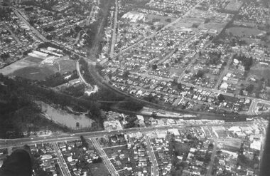
 Ringwood and District Historical Society
Photograph, Aerial view showing East Ringwood oval, Mount Dandenong Road, and Civic Centre, Braeside Avenue/Maroondah Hwy, c.1970
Aerial view showing East Ringwood oval, Mount Dandenong Road, and Civic Centre, Braeside Avenue/Maroondah Hwy, c.1970. -
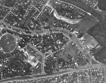
 Ringwood and District Historical Society
Photograph, Aerial view showing Mullum Ovals 1 and 2, Mullum Road. c.1970
Aerial view showing Mullum Ovals 1 and 2, Mullum Road. c.1970.