Showing 1405 items matching " public works"
-
 Kew Historical Society Inc
Photograph, Stuart Tompkins Studio, Electricity Supply Poles, North Road, Ormond, 1965
... examples of public works infrastructure being commissioned by local ...Research provided by Stuart Tompkins Studio, Box Hill, into alternatives for median strip street lighting to be used in Burke Road, Kew. The photographers identified variants in different suburbs appropriate to Kew's needs.The series from which the photograph is drawn provides a snapshot by a commercial photographic studio of each named vicinity in 1965 as well as providing examples of public works infrastructure being commissioned by local government in the 1960s. The photos originally formed part of the Engineering Department's files in the City of Kew before being donated to the kew Historical Society.Electricity Supply Poles, North Road, Ormond, 1965. Electricity supply poles photographed for the Kew City Council by Stuart Tompkins Studio. The photograph of North Road, Ormond west of Jasper Road, looking east depicts wooden poles carrying two lamps in a median strip and with two on each side alternately. It was noted that the supply wires were from one side only. The poles were described as 3′ above ground and 11.25″ in diameter. The plan was to use this approach for Burke Road, Kew. [There are three copies of this photograph in the Collection.] Typed inscription on reverse: "Electricity Supply Poles. Photographed for Kew City Council 8/2/65. No.1 North Road - Ormond, west of Jasper Road, looking east. Wooden poles carrying two lamps in median strip and two on each side alternately just as is proposed for Burke Road, Kew. Supply wires from one side only. Poles 3' above ground 11 1/4" dia." Studio stamp: "Stuart Tompkins Studio. 547 Station Street, Box Hill. WX1439."stuart tompkins studio, street lighting, south road (moorabin) 1965 -
 Kew Historical Society Inc
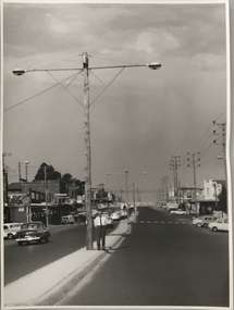
Photograph, Stuart Tompkins Studio, Electricity Supply Poles, Burke Road, Kew, 1965
... examples of public works infrastructure being commissioned by local ...Research provided by Stuart Tompkins Studio, Box Hill, into alternatives for median strip street lighting to be used in Burke Road, Kew. The photographers identified variants in different suburbs appropriate to Kew's needs.The series from which the photograph is drawn provides a snapshot by a commercial photographic studio of each named vicinity in 1965 as well as providing examples of public works infrastructure being commissioned by local government in the 1960s. The photos originally formed part of the Engineering Department's files in the City of Kew before being donated to the kew Historical Society.Electricity Supply Poles, Burke Road, Kew, 1965. This photograph of Burke Road, Kew was taken just north of Kilby and Doncaster Roads looking north. Stuart Tompkins Studio provided the photograph for the Kew City Council. In the photograph are a number of electricity supply poles that have been erected in the median strip, in addition to some new poles on each footpath. The nearest wooden pole is stated to be 13.5″ in diameter. The electricity poles in Burke Road required Kew Council to investigate comparable designs in other Melbourne municipalities. [There are three copies of this photograph in the Collection.] Typed inscription on reverse: "Electricity Supply Poles. Photographed for Kew City Council 8/2/65. No.5 Burke Road - Kew, just north of Kilby and Doncaster Roads looking north. Some of seven poles already erected in median strip. Shows also some new poles erected on each footpath. Nearest wooden pole 13 1/2" dia." Studio stamp: "Stuart Tompkins Studio. 547 Station Street, Box Hill. WX1439."stuart tompkins studio, street lighting, south road (moorabin) 1965 -
 Kew Historical Society Inc
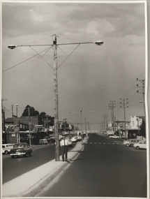
Photograph, Stuart Tompkins Studio, Electricity Supply Poles, Burke Road, Kew, 1965
... examples of public works infrastructure being commissioned by local ...Research provided by Stuart Tompkins Studio, Box Hill, into alternatives for median strip street lighting to be used in Burke Road, Kew. The photographers identified variants in different suburbs appropriate to Kew's needs.The series from which the photograph is drawn provides a snapshot by a commercial photographic studio of each named vicinity in 1965 as well as providing examples of public works infrastructure being commissioned by local government in the 1960s. The photos originally formed part of the Engineering Department's files in the City of Kew before being donated to the kew Historical Society.Electricity Supply Poles, Burke Road, Kew, 1965. This photograph of Burke Road, Kew was taken just north of Kilby and Doncaster Roads looking north. Stuart Tompkins Studio provided the photograph for the Kew City Council. In the photograph are a number of electricity supply poles that have been erected in the median strip, in addition to some new poles on each footpath. The nearest wooden pole is stated to be 13.5″ in diameter. The electricity poles in Burke Road required Kew Council to investigate comparable designs in other Melbourne municipalities. [There are three copies of this photograph in the Collection.] Typed inscription on reverse: "Electricity Supply Poles. Photographed for Kew City Council 8/2/65. No.5 Burke Road - Kew, just north of Kilby and Doncaster Roads looking north. Some of seven poles already erected in median strip. Shows also some new poles erected on each footpath. Nearest wooden pole 13 1/2" dia." Studio stamp: "Stuart Tompkins Studio. 547 Station Street, Box Hill. WX1439."stuart tompkins studio, street lighting, south road (moorabin) 1965 -
 Kew Historical Society Inc
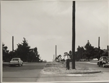
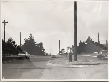
Photograph, Stuart Tompkins Studio, Electricity Supply Poles, Warrigal Road, Ashwood, 1965
... examples of public works infrastructure being commissioned by local ...Research provided by Stuart Tompkins Studio, Box Hill, into alternatives for median strip street lighting to be used in Burke Road, Kew. The photographers identified variants in different suburbs appropriate to Kew's needs.The series from which the photograph is drawn provides a snapshot by a commercial photographic studio of each named vicinity in 1965 as well as providing examples of public works infrastructure being commissioned by local government in the 1960s. The photos originally formed part of the Engineering Department's files in the City of Kew before being donated to the kew Historical Society.Electricity Supply Poles, Warrigal Road, Ashwood, 1965. Stuart Tompkins Studio provided this photograph for the Kew City Council. The photograph, taken at the intersection of Warrigal Road and High Street South, Ashwood looks north along High Street Road. The intent of the photograph was to provide the Council with models of electricity supply poles. In the photo, wooden and steel poles can be seen in the median strip. The photograph also includes the shops bordering High Street Road during this period. [There are three copies of this photograph in the Collection.]. Typed inscription on reverse: "Electricity Supply Poles. Photographed for Kew City Council 8/2/65. No.4 Warrigal Road - Ashwood. South of High Street Road looking north. Wooden and steel poles with different brackets in median strip." Studio stamp: "Stuart Tompkins Studio. 547 Station Street, Box Hill. WX1439."electric light poles, public infrastructure -- 1960s, civic works -- 1960s -
 Kew Historical Society Inc
Map, MMBW, River Yarra Beautification Schemes, c.1913
The Melbourne and Metropolitan Board of Works (MMBW) was established by an act of the Victorian Parliament in 1890 to prepare for and to implement a sewerage and water reticulation system across what was then inner Melbourne, its surrounding and middle distance suburbs, including Kew. The MMBW was disbanded in 1991.The map collection of the Kew Historical Society has at its core the historic maps assembled and originally stored in the City Engineer's Department of the City of Kew. These include maps in a number of scales. The vast majority of maps were produced by the MMBW in the first two decades of the twentieth century, and are solid working maps, backed by linen for durability. These maps are historically significant to Kew, the City of Boroondara and to the history of the development of state utilities in Victoria. A number of the Kew maps have additional details added by former municipal officers, including the levels reached by various floods. As these were working documents, information was added to them long after the period of their initial production and distribution.Map of the City of Kew showing part of the River Yarra Beautification Schemes. The map shows development to date and the flood levels reached in 1923 and 1924. This map may have been adapted from an earlier map, as most development in central Kew and Studley Park had occurred by this date yet numerous streets are not represented. Public buildings and institutions are clearly represented and named on the map as are significant public transport infrastructure (eg the Outer Circle railway).MELBOURNE AND METROPOLITAN BOARD OF WORKS / RIVER YARRA BEAUTIFICATION SCHEMES / SCHEME / SCALE 10 CHAINS TO AN INCHmelbourne & metropolitan board of works, mmbw maps, mmbw plans, city of kew, flood levels -- kew (vic.), cartography -
 Kew Historical Society Inc
Photograph - Opening of the Dorothy Rogers Reserve, 1976
Dorothy Rogers wrote two major books on Kew's history: Lovely Old Homes of Kew (1961) and A History of Kew (1973). In addition to her published works, she was a regular contributor on issues of local history to suburban newspapers. Her archives are held in the collections of the State Library of Victoria and Kew Historical Society. Three years after her death in 1973, the Reserve was opened in her honour.Faded colour positive photograph of the opening of the Dorothy Rogers Reserve in 1976. The naming of the reserve honoured the contribution of the historian Dorothy Rogers, foundation member of the Society. The reserve is located on the north side of Studley Park Road just west of Kew Junction. Inscribed verso: "Members and relatives of the late Dorothy Rogers. Memorial reserve named and unveiled in her honour by (Cr Whiting Mayor) and City Manager Mr Fell 1978. In respect for her great research and service to the history of early Kew, and other places."dorothy rogers reserve, public parks -- kew (vic.) -
 Kew Historical Society Inc
Photograph - Opening of the Dorothy Rogers Reserve, 1976
Dorothy Rogers wrote two major books on Kew's history: Lovely Old Homes of Kew (1961) and A History of Kew (1973). In addition to her published works, she was a regular contributor on issues of local history to suburban newspapers. Her archives are held in the collections of the State Library of Victoria and Kew Historical Society. Three years after her death in 1973, the Reserve was opened in her honour.Faded colour positive photograph of the opening of the Dorothy Rogers Reserve in 1976. The naming of the reserve honoured the contribution of the historian Dorothy Rogers, foundation member of the Society. The reserve is located on the north side of Studley Park Road just west of Kew Junction. Inscribed verso: "Left to right: Mrs Rogers Jnr, Joy Stewart, Miss Jenkins sitting / Mrs Richardson and Mr Richardson, Brother of D. Rogers), Mayor Cr Whiting, City Manager Mr Fell, Background / KHS President Miss Hall, Mr B O'Neill KHS member, / taken during the memorial unveiling of the Dorothy Rogers Reserve"dorothy rogers reserve, public parks -- kew (vic.) -
 Kew Historical Society Inc
Photograph - Flooding of the Yarra Valley at Kew East, 1974
Flooding of the Yarra Valley, including that section of the Yarra bordering Kew and Kew East in the north and west of the municipality, was a regular occurrence. Extreme flood events of the Yarra River are recorded to have occurred in 1891, 1901, 1916, 1923 and 1934. The Municipality of Kew's response to these floods was to enact planning decisions restricting residential development in flood prone areas following the floods of 1916, 1921 and 1934. While floods continued after the development of the Upper Yarra Reservoir (construction 1948-57), the regularity and extent of these inundations diminished. During the nineteenth century, the land abutting the south side of the Yarra in Kew was devoted to dairy farming. In the twentieth century, before and after the construction of the Eastern Freeway, much of this low-lying area was used as golf courses and public parks.Late example of the capacity of the Yarra Valley at Kew to flood, even though drainage works and the Upper Yarra Reservoir had reduced their regularity.Original black and white print photograph of the low-lying land at East Kew under floodwater on 16 May 1974. The vantage point of the photographer is Lister Street. In the photo, the fences of the Kilby Farm can be seen. Flooding was caused by overflowing water in Glass' Creek and the River Yarra. Annotation verso: "Hay's Paddock op No.30 Lister Street / 16 May 1974 11.50am / R.L. 46.04"hays paddock, floods, yarra river, glass' creek, lister street -
 Kew Historical Society Inc
Photograph - Flooding of the Yarra Valley at Kew East, 1974
Flooding of the Yarra Valley, including that section of the Yarra bordering Kew and Kew East in the north and west of the municipality, was a regular occurrence. Extreme flood events of the Yarra River are recorded to have occurred in 1891, 1901, 1916, 1923 and 1934. The Municipality of Kew's response to these floods was to enact planning decisions restricting residential development in flood prone areas following the floods of 1916, 1921 and 1934. While floods continued after the development of the Upper Yarra Reservoir (construction 1948-57), the regularity and extent of these inundations diminished. During the nineteenth century, the land abutting the south side of the Yarra in Kew was devoted to dairy farming. In the twentieth century, before and after the construction of the Eastern Freeway, much of this low-lying area was used as golf courses and public parks.Late example of the capacity of the Yarra Valley at Kew to flood, even though drainage works and the Upper Yarra Reservoir had reduced their regularity.Original black and white print photograph of the low-lying land at East Kew under floodwater on 16 May 1974. The vantage point of the photographer is Lister Street. Flooding was caused by overflowing water in Glass' Creek and the River Yarra. Annotation verso: "Lister Street looking north / Flood level / 16 May 1974 11.30am / R.L. 46.04"hays paddock, floods, yarra river, glass' creek, lister street -
 Kew Historical Society Inc
Photograph - Flooding of the Yarra Valley at Kew East, 1974
Flooding of the Yarra Valley, including that section of the Yarra bordering Kew and Kew East in the north and west of the municipality, was a regular occurrence. Extreme flood events of the Yarra River are recorded to have occurred in 1891, 1901, 1916, 1923 and 1934. The Municipality of Kew's response to these floods was to enact planning decisions restricting residential development in flood prone areas following the floods of 1916, 1921 and 1934. While floods continued after the development of the Upper Yarra Reservoir (construction 1948-57), the regularity and extent of these inundations diminished. During the nineteenth century, the land abutting the south side of the Yarra in Kew was devoted to dairy farming. In the twentieth century, before and after the construction of the Eastern Freeway, much of this low-lying area was used as golf courses and public parks.Late example of the capacity of the Yarra Valley at Kew to flood, even though drainage works and the Upper Yarra Reservoir had reduced their regularity.Original black and white print photograph of Hay's Paddock under floodwater on 16 May 1974. The vantage point of the photographer is Keystone Crescent looking east. Flooding was caused by overflowing water in Glass' Creek and the River Yarra. Annotation verso: "Keystone Cr looking east / 16 May 1974 11.50am"hays paddock, floods, yarra river, glass' creek -
 Kew Historical Society Inc
Photograph - Flooding of the Yarra Valley at Kew East, 1974
Flooding of the Yarra Valley, including that section of the Yarra bordering Kew and Kew East in the north and west of the municipality, was a regular occurrence. Extreme flood events of the Yarra River are recorded to have occurred in 1891, 1901, 1916, 1923 and 1934. The Municipality of Kew's response to these floods was to enact planning decisions restricting residential development in flood prone areas following the floods of 1916, 1921 and 1934. While floods continued after the development of the Upper Yarra Reservoir (construction 1948-57), the regularity and extent of these inundations diminished. During the nineteenth century, the land abutting the south side of the Yarra in Kew was devoted to dairy farming. In the twentieth century, before and after the construction of the Eastern Freeway, much of this low-lying area was used as golf courses and public parks.Late example of the capacity of the Yarra Valley at Kew to flood, even though drainage works and the Upper Yarra Reservoir had reduced their regularity.Original black and white print photograph of the low-lying land at East Kew under floodwater on 16 May 1974. The vantage point of the photographer is Lister Street. Flooding was caused by overflowing water in Glass' Creek and the River Yarra. Annotation verso: "Lister St looking same as No.3 / 16 May 1974 11.30"floods, yarra river, glass' creek, lister street -
 Kew Historical Society Inc
Photograph - Flooding of the Yarra Valley at Kew East, 1974
Flooding of the Yarra Valley, including that section of the Yarra bordering Kew and Kew East in the north and west of the municipality, was a regular occurrence. Extreme flood events of the Yarra River are recorded to have occurred in 1891, 1901, 1916, 1923 and 1934. The Municipality of Kew's response to these floods was to enact planning decisions restricting residential development in flood prone areas following the floods of 1916, 1921 and 1934. While floods continued after the development of the Upper Yarra Reservoir (construction 1948-57), the regularity and extent of these inundations diminished. During the nineteenth century, the land abutting the south side of the Yarra in Kew was devoted to dairy farming. In the twentieth century, before and after the construction of the Eastern Freeway, much of this low-lying area was used as golf courses and public parks.Late example of the capacity of the Yarra Valley at Kew to flood, even though drainage works and the Upper Yarra Reservoir had reduced their regularity.Original black and white print photograph of the low-lying land at East Kew under floodwater on 16 May 1974. The vantage point of the photographer is at Willsmere Road. The road itself is underwater.Annotation verso: "Willsmere Rd / Same as No.7 / 16 May 1974 11.15am"floods, yarra river, willsmere road -
 Kew Historical Society Inc
Photograph - Flooding of the Yarra Valley at Kew East, 1974
Flooding of the Yarra Valley, including that section of the Yarra bordering Kew and Kew East in the north and west of the municipality, was a regular occurrence. Extreme flood events of the Yarra River are recorded to have occurred in 1891, 1901, 1916, 1923 and 1934. The Municipality of Kew's response to these floods was to enact planning decisions restricting residential development in flood prone areas following the floods of 1916, 1921 and 1934. While floods continued after the development of the Upper Yarra Reservoir (construction 1948-57), the regularity and extent of these inundations diminished. During the nineteenth century, the land abutting the south side of the Yarra in Kew was devoted to dairy farming. In the twentieth century, before and after the construction of the Eastern Freeway, much of this low-lying area was used as golf courses and public parks.Late example of the capacity of the Yarra Valley at Kew to flood, even though drainage works and the Upper Yarra Reservoir had reduced their regularity.Original black and white print photograph of the low-lying land at East Kew under floodwater on 16 May 1974. The photograph is of Hyde Park looking north-east.Annotation verso: "Hyde Park looking nth-east / Flood Level / 16 May 1974 11.15am / R.L. 46.61"floods, yarra river, hyde park -
 Kew Historical Society Inc
Photograph - Flooding of the Yarra Valley at Kew, 1974
Flooding of the Yarra Valley, including that section of the Yarra bordering Kew and Kew East in the north and west of the municipality, was a regular occurrence. Extreme flood events of the Yarra River are recorded to have occurred in 1891, 1901, 1916, 1923 and 1934. The Municipality of Kew's response to these floods was to enact planning decisions restricting residential development in flood prone areas following the floods of 1916, 1921 and 1934. While floods continued after the development of the Upper Yarra Reservoir (construction 1948-57), the regularity and extent of these inundations diminished. During the nineteenth century, the land abutting the south side of the Yarra in Kew was devoted to dairy farming. In the twentieth century, before and after the construction of the Eastern Freeway, much of this low-lying area was used as golf courses and public parks.Late example of the capacity of the Yarra Valley at Kew to flood, even though drainage works and the Upper Yarra Reservoir had reduced their regularity.Original black and white print photograph of the low-lying land at East Kew under floodwater on 16 May 1974. The photograph is taken from 43 Kellett Grove.Annotation verso: "Kellett Gve No.43 / Flood Level / 16 May 1974 11.40am"floods, yarra river, kellett grove -
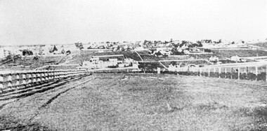 Surrey Hills Historical Society Collection
Photograph, Looking towards Box Hill from the site of the Surrey Hills Golf Club, 1902, 1902
... golf club riversdale golf club box hill gas works gasworks ...Reproduced by permission of Mr John Arnold from his book: "The Riversdale Golf Club - a history, 1892-1977." Copyright to book: Riversdale Golf Club. Surrey Hills Golf Club operated from 1892-1908 then moved and became Riversdale Golf Club. The game was played across paddocks from Trafalgar Street, Mont Albert to Whitehorse Road and down Victoria Crescent to where Box Hill TAFE is now located in Elgar Road. There were problems with cows eating the tee flags! The clubhouse still exists as 30 Trafalgar Street.Black and white photo with a large grassy paddock in the foreground. From the bottom left and right post-and-rail fences converge on a group of large industrial buildings in the centre middle distance. In the background are paddocks and buildings."Top: Looking towards Box Hill from the links in 1902. The old Box Hill Gas Works is in the centre of the picture."sports grounds, surrey hills golf club, riversdale golf club, box hill gas works, gasworks, public utilities, gas -
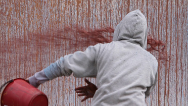 Federation University Art Collection
Artwork, other - Artwork, "West Park Proposition' by Ash Keating, 2013
Ash KEATING Among fifteen finalists this artwork won the 2012 Guirguis New Art Prize, a prestigious national acquisitive biennial art prize administered by Federation University Australia. The Guirguis New Art Prize (GNAP) is a national acquisitive $20,000 contemporary art prize which presents a selection of Australia's most exciting contemporary artists with works that explore and embrace new ways of artistic expression, utilising existing mediums and new technologies in innovative ways. Initiated and generously supported by local Ballarat surgeon Mr Mark Guirguis, this prestigious art prize is administered by the Federation University Australia (FedUni). As a local philanthropist and art collector, in developing the Prize, Mark Guirguis' aims were to celebrate the significance of the arts to communities and to Ballarat, emphasising contemporary art and 'living' culture, and to highlight FedUni's Arts Academy. Artist Ash Keating works across a conceptual, site-responsive and often collaborative art practice that incorporates painting, sculpture, installation, video, performance and public interventions, and has referenced a wide range of social and environmental issues within his art. Frequently working beyond the gallery, and often harnessing community narrative and energy, his work also draws upon myth, ritual and ceremony. 'West Park Proposition', 2012, is a three channel and screen video installation, utilising multiple camera video documentation of an endurance painting intervention undertaken on the morning of 01 September 2012 on the east facing wall of a newly built tilt-slab industrial building, situated on the direct edge of the current urban and rural boundary in Truganina, Victoria. The multi-screen work documents an endurance guerilla-style action painting intervention and ritualised painting performance in which a symbolic violence is enacted against a storehouse of commodity production and consumption. Upon winning the award artists Ash Keating said; “The work was made near Ballarat on the Deer Park bypass. It is an aesthetic comment about the way these new tilt-slab industrial buildings spring up without caring for the environment." The work, which took eight hours to create, was about reclaiming the space from “cost-effective architecture” without any aesthetics. The inaugural judge for the Prize, Jason Smith, Director, Heide Museum of Modern Art (MoMA) said, "Selecting the winner of this inaugural GNAP was exhilarating and excruciating: exhilarating because the seriousness of each artist's enterprise, and their uncompromising resolution of concepts, has created an inaugural exhibition of exceptional power. This first GNAP is a survey of some of the most poetic and provocative imaginations working in Australia today. Selecting one winner from such a show in which each of these artists has in some way transformed my thinking about the world was the excruciating part. Ash Keating's work West Park Proposition, 2012 kept drawing me back in the several hours I spent viewing the works. It simultaneously affirms the political and critical role of the artist as a key agent of change and action, and someone who reminds us of the beauty and resilience of humanity and nature in the face of unrelenting change. As a work combining performance, collaboration and hope, Keating's West Park Proposition is a work of immense and compelling poetry."artist, artwork, keating, ash keating, guirguis, guirguis new art prize, gnap, gnap13 -
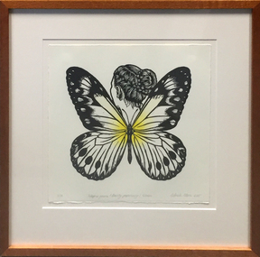 Federation University Art Collection
Work on paper - Printmaking, Deborah Klein, 'Ideaopsis Gaura (Dainty Paperwing)' by Deborah Klein, 2015
Deborah KLEIN (1951- ) Born Melbourne, Victorian Deborah Klein grew up in the inner southern suburb of St. Kilda and lived and worked in London from 1973 - 1980. The experience of living in both of these places was to have a significant and enduring influence on her work. She gained degree and post degree qualifications from Chisholm Institute of Technology, Melbourne and Gippsland College of Advanced Education, and a Research MA from Monash University, Gippsland. Since 1988 Deborah Klein has held regular solo exhibitions and participated in group exhibitions in Australia and internationally. Her work is represented in public and university museum collections throughout Australia. This work was exhibited as part of "Parallel Prints", a Prints project which presents the same exhibition simultaneously in New Zealand, at Art at Wharepuke and at a gallery in another part of the world. Eleven Australian artists were invited to join New Zealand-based printmaker Mark Graver to contribute to a portfolio that will be shown simultaneously at Art at Wharepuke, New Zealand and the Art Gallery of Ballarat, Victoria. Using the uniqueness of the reproducible print allows for the same works to be viewed at the same time on opposite sides of the world. This highlights the democratic nature of printmaking and questions the aura of the unique. Which venue is showing the 'real' work? Which the reproduction? The Australian artists showing alongside Mark Graver are James Pasakos, Bruno Leti, Martin King, David Frazer, John Neeson, Antonietta Covino-Beehre, Deborah Klein, Deborah Williams, Melissa Smith, Jodi Heffernan and Susanna Castleden. The original concept, Parallel Prints NZ-UK in 2013, included invited artists from the UK and New Zealand. It featured the work of twelve diverse artists presented in a portfolio set. Each artist contributed one work on 300 x 300 mm paper in an edition of thirty-six. Part of the concept behind the project was to donate twelve of the portfolio sets to international collections. Institutions that have accepted a portfolio include the Victoria & Albert Museum and The Ashmolean Museum in the UK, the Jinling Museum of Art in Nanjing, China, and the Whangarei Art Museum, in New Zealand. In 2015 a portfolio set was donated to the Federation University Art Collection. This item is part of the Federation University Art Collection. The Art Collection features over 2000 works and was listed as a 'Ballarat Treasure' in 2007.Framed, handcoloured linocut depicting a butterly with a female head with braided hair.Edition 2/36artist, artwork, deborah klein, klein, butterfly, insect, animal, printmaking, linocut, parallel prints, alumni -
 Federation University Art Collection
Oil on canvas, 'Creswick and Camp Hill' by Victor Litherland, 1968 /1984
Victor LITHERLAND (16 April 1897 - 1978_ Born Odessa, Russia (of English parents) Born in Odessa, Russia to British parents, Victor Litherland migrated to Australia in 1926 and moved to Creswick in 1932. Victor Litherland, who initially trained as a carpenter and cabinet maker, not only made most of his furniture and clothes but also his painting equipment. Victor Litherland is self taught himself. In 1943 he used books in the Sydney Public Library to teach himself painting, and produced a number of works of the environment in which he lived. Litherland's work has a disregard for perspective, unmodelled faces and cool fresh colours. He often made an elaborate frame for this work. This item is part of the Federation University Art Collection. The Art Collection features over 1000 works and was listed as a 'Ballarat Treasure' in 2007.art, artwork, victor litherland, naive art, creswick, acrylic on canvas -
![Painting - Watercolour, [The Towel] by Neville Bunning](/media/collectors/530576742162ef0fa09a2288/items/534748159821f420f8c03638/item-media/599fefe121ea6d0cdcde0f21/item-fit-380x285.jpg) Federation University Art Collection
Federation University Art CollectionPainting - Watercolour, [The Towel] by Neville Bunning
Neville Bunning taught Sculpture and Ceramics at the School of Mines and Industry, Ballarat between 1945 and 1964. During that time he formed the Ballarat Artist’s Society, a group that sponsored art and invited modernist artists to visit Ballarat to speak to students and the public. Bunning wrote a weekly art column in The Courier, where his insightful comments made readers aware of significant trends in Art. This item is part of the Federation University Art Collection. The Art Collection features over 1000 works and was listed as a 'Ballarat Treasure' in 2007.Framed watercolour.art, artwork, neville bunning, bunning, watercolour, watercolor -
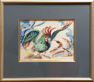 Federation University Art Collection
Painting - Watercolour and Ink, 'The Firebird' by Neville Bunning
Neville BUNNING (1902-1990) Born Rockhampton Neville Bunning taught Sculpture and Ceramics at the Ballarat Technical Art School between 1945 and 1964. During that time he started the Ballarat Artists's Society, a group tat sponsored art and invited modernist artists to visit Ballarat to speak to students and the public. Bunning wrote a weekly rt column in 'The Courier' where his insightful comments made readers aware of significant trends in Art. This item is part of the Federation University Art Collection. The Art Collection features over 2000 works and was listed as a 'Ballarat Treasure' in 2007.Framed painting of a bird in flight.art, artwork, neville bunning, watercolour, ballarat artists society, ballarat school of mines, available, rooster, bird, animal -
 Federation University Art Collection
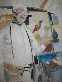
Painting - Oil on board, Neville Bunning, Self Portrait (unfinished) by Neville Bunning, 1997
Neville Bunning taught Sculpture and ceramics at the Ballarat Technical Art School, a division of the Ballarat School of mines, from 1945 until 1964. During that time he formed the Ballarat Artist's Society, a group that sponsored art and invited modernist artists to visit Ballarat to speak to students and the public. Bunning wrote a weekly column in 'The Courier', where his insightful comments made readers aware of significant trends in art. This item is part of the Federation University Art Collection. The Art Collection features over 1000 works and was listed as a 'Ballarat Treasure' in 2007.A framed unfinished portrait by Neville Bunning, teacher of Ceramics at the Ballarat School of Mines. The portrait of the artists shows a camera around his neck, a ceramic pot in one hand, and some of Neville Bunnings paintings in the background.art, artwork, neville bunning, bunning, available -
 Federation University Art Collection
Print - limited edition screenprint, Danny MacDonald, 'Taxonomer's Vision' by Danny McDonald, 1997
Danny McDONALD (1949- ) Born Australia Since 2000, Danny McDonald's art practice has been largely focused on medical research and public installation activity. Images show evidence of his foray into medical science's image-making techniques and demonstrate his hypothesis that art and science are intimately linked in their 'objective' outlook on the world. This item is part of the Federation University Art Collection. The Art Collection features over 2000 works and was listed as a 'Ballarat Treasure' in 2007.Framed colour jetspray and seriagraphart, artwork, danny mcdonald, serigraph -
![Sculpture (exterior), [Untitled Sculpture] by Mary Modeen, 2000, 2000](/media/collectors/530576742162ef0fa09a2288/items/534748159821f420f8c036c3/item-media/5a66d60a21ea6e0d186d7a03/item-fit-380x285.jpg) Federation University Art Collection
Federation University Art CollectionSculpture (exterior), [Untitled Sculpture] by Mary Modeen, 2000, 2000
Mary MODEEN (1953- ) Born United States of America Lives Scotland Mary Modeen is an artist/printmaker and interdisciplinary academic who also works in artist books, installations, and recently, in video and sound. She is also an academic of nearly 30 years full-time experience in higher education, residing in Scotland where she convenes the Art, Philosophy and Contemporary Practices at the Duncan of Jordanstone College of Art and Design, University of Dundee. Modeen’s research has several threads: perception as a cognitive and interpretive process, and place-based research, which tends to connect cultural values, history and embodied experience. In 2000, while a Visiting Research Fellow at the University of Ballarat (later Federation University Australia), Mary Modeen was commissioned to create a sculpture in a Public Art context for the campus. This item is part of the Federation University Art Collection. The Art Collection features over 1000 works and was listed as a 'Ballarat Treasure' in 2007.An external sculpture commissioned in a Public Art context for the Mt Helen campus Business Building (B Building) by Scottish Artist and Visiting Research Fellow, Mary Modeen. Mary Modeen's three dimensional sculptures and installations draw on her interest in "light" relating to artworks and conceptual art. The 'plugs' in the sculpture represent students, while the blue acrylic disk represents alumni, and the spread and impact of our students throughout the community. art, artwork, sculpture, mary modeen, business school art collection -
 Federation University Art Collection
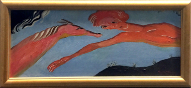
Painting - Oil on board, Neville Bunning, 'Hand of Friendship' by Neville Bunning
Neville Mirvane BUNNING (1902-1990) During World War Two Neville Bunning served with the Royal Australian Air Force (RAAF). He was an Art Teacher at the Ballarat Technical Art School (a division of the Ballarat School of Mines) from 05 February 1946 to 22 September 1964. Neville Bunning formed the Ballarat Artist's Society (later the Ballarat Society of Artists), a group that sponsored art and which invited modernist artists to speak to students and to the public of Ballarat. He also wrote a weekly column in the Ballarat Courier. Bunning produced a bust of Australian Prime Minister, The Right Honourable J.A. Lyons from Tasmania, who died in office. Neville Bunning died in Subiaco, Western Australia on 29 April 1990. This item is part of the Federation University Art Collection. The Art Collection features over 2000 works and was listed as a 'Ballarat Treasure' in 2007.Framed painting of a surrealist inspired painting of a person with a horse. art, artwork, neville bunning, horse, oil painting, oil on board, bunning, available -
![Painting - Watercolour, Neville Bunning, [The Yellow Jumper] by Neville Bunning](/media/collectors/530576742162ef0fa09a2288/items/534748159821f420f8c036d0/item-media/5f5cb2ef615430146040b0ba/item-fit-380x285.jpg) Federation University Art Collection
Federation University Art CollectionPainting - Watercolour, Neville Bunning, [The Yellow Jumper] by Neville Bunning
Neville Mirvane BUNNING (1902-1990) During World War Two Neville Bunning served with the Royal Australian Air Force (RAAF). He was an Art Teacher at the Ballarat Technical Art School (a division of the Ballarat School of Mines) from 05 February 1946 to 22 September 1964. Neville Bunning formed the Ballarat Artist's Society (later the Ballarat Society of Artists), a group that sponsored art and which invited modernist artists to speak to students and to the public of Ballarat. He also wrote a weekly column in the Ballarat Courier. Bunning produced a bust of Australian Prime Minister, The Right Honourable J.A. Lyons from Tasmania, who died in office. Neville Bunning died in Subiaco, Western Australia on 29 April 1990. This item is part of the Federation University Art Collection. The Art Collection features over 2000 works and was listed as a 'Ballarat Treasure' in 2007.Portrait of a girl in a yellow jumper art, artwork, available, neville bunning, boy, portrait -
![Painting - Artwork, [Portrait] by Neville Bunning](/media/collectors/530576742162ef0fa09a2288/items/534748159821f420f8c036ff/item-media/581c0e60d0cdd101e0c2264e/item-fit-380x285.jpg) Federation University Art Collection
Federation University Art CollectionPainting - Artwork, [Portrait] by Neville Bunning
Neville Mirvane BUNNING (1902-1990) During World War Two he served with the RAAF. He was an Art Teacher at the Ballarat School of Mines from 05 February 1946 to 22 September 1964. Neville Bunning formed the Ballarat Artist's Society (later the Ballarat Society of Artists), a group that sponsored art and which invited modernist artists to speak to students and to the public of Ballarat. He also wrote a weekly column in the Ballarat Courier. Bunning produced a bust of Australian Prime Minister, The Right Honourable J.A. Lyons from Tasmania, who died in office. Bunning died in Subiaco, Western Australia on 29 April 1990. This item is part of the Federation University Art Collection. The Art Collection features over 1000 works and was listed as a 'Ballarat Treasure' in 2007.Framed watercolour of a woman surrounded by flowersBlack marker signature on the backart, artwork, neville bunning -
![Watercolour on paper, [Camp site with washing] by Neville Bunning](/media/collectors/530576742162ef0fa09a2288/items/534748159821f420f8c03702/item-media/58185564d0cdd12fd0913d4a/item-fit-380x285.jpg) Federation University Art Collection
Federation University Art CollectionWatercolour on paper, [Camp site with washing] by Neville Bunning
Neville Mirvane BUNNING (1902-1990) During World War Two he served with the RAAF. He was an Art Teacher at the Ballarat School of Mines from 05 February 1946 to 22 September 1964. Neville Bunning formed the Ballarat Artist's Society (later the Ballarat Society of Artists), a group that sponsored art and which invited modernist artists to speak to students and to the public of Ballarat. He also wrote a weekly column in the Ballarat Courier. Bunning produced a bust of Australian Prime Minister, The Right Honourable J.A. Lyons from Tasmania, who died in office. Bunning died in Subiaco, Western Australia on 29 April 1990. This item is part of the Federation University Art Collection. The Art Collection features over 1000 works and was listed as a 'Ballarat Treasure' in 2007.Framed watercolour and pencil on paperLR Neville M Bunning signature in pencilart, artwork, neville bunning, campsite, camping, washing, available, holiday, ballarat technical art school staffmember -
 Federation University Art Collection
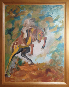
Painting, Neville Bunning, 'The Buckjumper' by Neville Bunning
Neville Bunning taught Sculpture and ceramiCs at the Ballarat Technical Art School, a division of the Ballarat School of mines, from 1945 until 1964. During that time he formed the Ballarat Artist's Society, a group that sponsored art and invited modernist artists to visit Ballarat to speak to students and the public. Bunning wrote a weekly column in 'The Courier', where his insightful comments made readers aware of significant trends in art. This item is part of the Federation University Art Collection. The Art Collection features over 1000 works and was listed as a 'Ballarat Treasure' in 2007.Oil painting depicting a horse and rider.art, artwork, neville bunning, horse, bunning, available