Showing 12221 items matching " reserves"
-
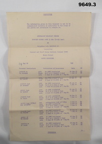 Bendigo Military Museum
Document - ROUTINE ORDERS, Aust Dept of Defence, c1961
The ACMF was the Australian Citizen Military Forces and was the Army Reserve. Part of the collection of "William Fawcett" V246452 refer Cat No 9627.Three (3) cream colour foolscap sheets with writing in purple, lists 33 officers who have been terminated from ACMF and transferred to Royal Aust Infantry or other related units.Headed: "Routine orders Part 11 No's 77-145 incl. By Brigadier S.M. McDONALD MC", "RESTRICTED".cmf, termination of contract, fawcett 1 -
 Warrnambool and District Historical Society Inc.
Administrative record - Minutes Book Sub Committees, Warrnambool City Council 1950-1973, Circa 1950
This book contains the minutes from a wide range of community groups such as Sun Youth Travel Scheme, Foreshore Reserve Committee of Management, Victorian Centenary Celebration, and Testimonials for various councillors, Freedom from Hunger Campaign, Historical Society, Miss Australia Quest, Meals on Wheels, Winston Churchill Memorial Appeal, and Warrnambool Cricket Grand Reserve. The meetings were held in the period 1950 to 1973.An interesting collection of minutes with a very diverse cross-section of community groups. It shows the workings of councillors with a range of community groups some of which such as Meals On Wheels have become an important part of community support for people. Red cover. Navy blue and white patterned inside front and back covers.188 blue lined pages with handwritten minutes for various sub committees and community groups.The letter M on base of spine. A shell series Product No 4222. warrnambool, minute book minutes book 1950- 1973, warrnambool and district historical society, sun youth travel scheme, warrnambool foreshore reserve committee of management, victorian centenary celebration, freedom from hunger campaign, miss australia quest, meals on wheels, winston churchill memorial appeal, warrnambool cricket grand reserve -
 Greensborough Historical Society
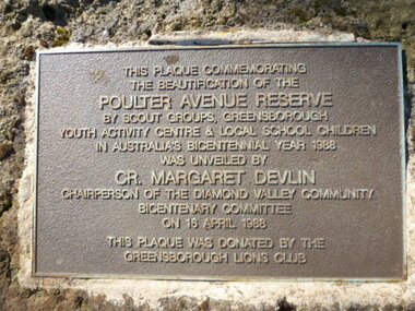
Photograph - Digital image, Plaque - Poulter Avenue Reserve Greensborough, 18/04/1988
Photograph of Plaque located in Greensborough's Poulter Avenue Reserve. The inscription reads: "This plaque commemorating the beautification of the Poulter Avenue Reserve by scout groups, Greensborough Youth Activity Centre & local school children in Australia's Bicentennial year 1988 was unveiled by Cr. Margaret Devlin chairperson of the Diamond Valley Community Bicentenary Committee on 18 April 1988. This plaque was donated by the Greensborough Lions Club" Digital copy of colour photograph.poulter avenue reserve greensborough -
 Ithacan Historical Society
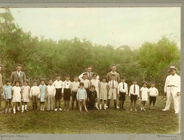
Photograph, Ithacan picnic
The photograph was taken at an Ithacan Club annual picnic. The picnic were held on recreation grounds located on Melbourne's rural fringe. For many years Maddingley Reserve, Bacchus Marsh was the regular location; and more recently Ferny Creek Reserve. Running races continue to be run for all age groups are a popular activity during the day. In this photograph the children are lining up for the 75 yards race.A sepia photograph taken in the country of a row of children lining up at thew start of a race. Five men are standing behind them. -
 Greensborough Historical Society
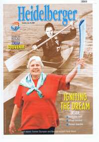
Newspaper - Newspaper Clipping, The Heidelberger, Memories relit for Heidies, 2000
Heidi Beard, canoeist at the 1960 Rome Olympics, carried the Olympic flame into Heidelberg West's Olympic Reserve on 30 July 2000Two pages from "The Heidelberger" (25/07/2000 & 01/08/2000)Memories relit for Heidiesheidi beard, olympic torch relay, olympic games sydney 2000, beard family -
 Greensborough Historical Society
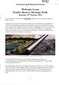
Booklet, Greensborough Historical Society, Poulter Reserve Heritage Walk, 29/10/2022
The Poulter Reserve precinct is bordered by the railway line, Main Street and the Plenty River. This booklet accompanies a guided walk around the area.20 p., text and color and black and white images.poulter reserve greensborough, main street greensborough, plenty river greensborough -
 Greensborough Historical Society
Letter, Banyule City Council, A new playground and bike education track for Delta Reserve, 17/02/2020
Banyule City Council letter informing residents of plans to upgrade Delta Reserve, Greensborough, including a new bike education track1 p. letter on Banyule City Council letterheaddelta road reserve, bike education, parks and reserves, banyule city council -
 Greensborough Historical Society
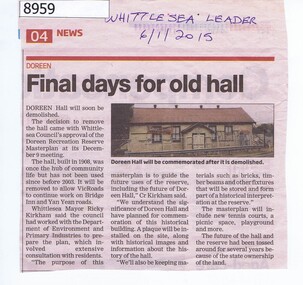
Article - Newspaper Clipping, Whittlesea Leader, Final days for old hall Doreen, 06/01/2015
In 2015 the Doreen Hall was demolished as part of the Doreen Recreation Reserve masterplan and to allow works on Bridge Inn and Yan Yean Roads.Newspaper Clipping, text and colour imagedoreen, whittlesea, doreen community hall -
 Robin Boyd Foundation
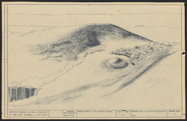
Drawing - Aerial perspective, Tower Hill Lake Reserve Museum, Jun-61
Project: Tower Hill Lake Reserve Museum drawn by Robin Boyd of Grounds, Romberg & Boyd. Drawing no 1. Aerial perspectiveSketch, Dyeline -
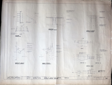 Robin Boyd Foundation
Drawing - Architectural, Tower Hill State Game Reserve Natural History Centre, 3-Jan-64
Project: Tower Hill State Game Reserve Natural History Centre drawn by B. of Romberg & Boyd . Drawing no. 14. Details.Working Drawing, Dyeline -
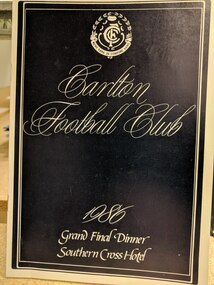 Carlton Football Club
Small Booklet, Carlton Football Club 1986 Grand Final Dinner, Southern Cross Hotel
Includes pictures of board of directors, and senior and reserves grand finalists. Includes player and coach autographs. From Roger Skien Collection.Soft cover 4 pagesIncludes players autographs -
 Canterbury History Group
Letter - Blue mystery in the works- letter in the Progress Press 4 July 2006, Ken Lyall, July 2006
Letter to the editor responding the origin of the Blue Hole, short history of the Mont Albert Brickworks which is now the John August Reserve6 paragraphs and letterjohn august reserve, parks and reserves, brickworks -
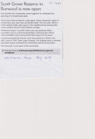 Whitehorse Historical Society Inc.
Article, Scott Grove Reserve, Aug 2023
A new open space park has been established at 14 - 16 Scott Grove, Burwoodnon-fictionA new open space park has been established at 14 - 16 Scott Grove, Burwoodscott grove reserve, scott grove burwood no 14 -16, playgrounds -
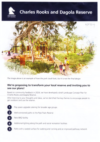 Whitehorse Historical Society Inc.
Document, Charles Rooks and Dagola Reserve, 19/03/2025
The Whitehorse City Council is proposing to transform the Charles Rooks and Dagola Reserve and is inviting residents to view plans and comment by 17/03/2025non-fictionThe Whitehorse City Council is proposing to transform the Charles Rooks and Dagola Reserve and is inviting residents to view plans and comment by 17/03/2025dagola avenue nunawading, charles rooks and dagola reserve, pipe line reserve, parks and reserves, lorikeet avenue nunawading -
Box Hill Historical Society
Photograph - Gardiners Creek
View of sculpture at Gardiner's Creek Reserve between Highbury Road and Burwood Highway. One of a collection of "Time" sculptures. December 1985sculpture, gardiners creek reserve, parks and reserves, highbury road, burwood highway -
 Kiewa Valley Historical Society
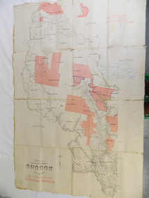
Map - Kiewa Valley, County Map of Bogong, 27/11/1905
This map has been owned by the Ryder Family of the Kiewa Valley for possibly over 100 years (1905?). It was used when the family mustered and maintained cattle on their grazing lease on the Bogong High Plains. Obviously a field map used on these occasions.This map was used by the Ryder Family who lived in the Kiewa Valley and who grazed cattle on their lease on the Bogong High Plains during summer.Showing reserves Under the Forest Act of 1907. This is a paper map which has been mounted or glued on pink and cream floral cotton. It is obvious by its poor condition that it has been used outdoors in the field. It is not in very good condition as it has been folded 4 times (8 divisions) and it is badly worn and cracked in the creases.Photo Lithographed at the Department of Lands and Surveys by T.E.McGauran 27/11/05 Price 1/3d. Scale - 2 miles to an inch. F.S. Hilcke Oct. 2nd 1905.department of lands and surveys map; ryder family; bogong high plains -
 Bendigo Historical Society Inc.
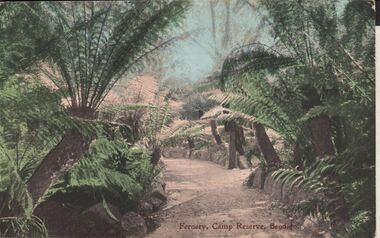
Postcard - ELAINE ROBB COLLECTION: BENDIGO FERNERY
Hand coloured postcard: image shows Fernery, Rosalind Park, Bendigo. In centre of image, gravel pathway bordered by stonework, ferns on either side. On bottom of card: Fernery,Camp Reserve, Bendigo. Possibly late 1890's ? On rear of card: Post card W.T.P. in ornate diamond shape (produced by WT Pater, printers & stationers )W.T.Pater -
 Bendigo Historical Society Inc.
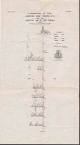
Map - STRUGNELL COLLECTION: HUSTLER'S LINE OF REEFS, BENDIGO, September 1913
Map, Hustler's Line of Reef, Hustler's Royal Reserve No. 2, Park Shaft, Bendigo, Plate No. 1X (9). Bulletin No 33 Signed H.A.Whitelaw Underground survey Office Bendigo September 1913 Drawing shows mine shaft to over 1099 feet deep and appears to show samples of connecting horizontal shafts with their respective mineral contentsUnderground Survey Office, Bendigo.map, bendigo, hustler's royal reserve no. 2 mine* -
 Bendigo Historical Society Inc.
Document - MCCOLL, RANKIN AND STANISTREET COLLECTION: DEBORAH GOLD MINES NL GOLD MINING LEASE DOC, 1941
Document: McColl, Rankin and Stanistreet: Gold Mining Lease Private Land, 11089 Bendigo on front of document., Deborah Gold Mines NL - 3 pages, with map. Lease adjoins Railway Reserve, Breen Street. Transferred to North Deborah Mining Company NL on 9th. October, 1950. No. 11089, Vol 326 Fol 35941.organization, mining, gold mining lease, mccoll, rankin and stanistreet:, deborah gold mines nl, north deborah mining company nl, gold mining, lease -
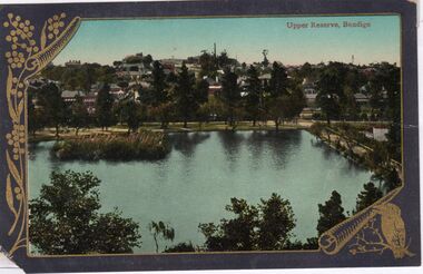 Bendigo Historical Society Inc.
Postcard - CARWARDINE COLLECTION: UPPER RESERVE BENDIGO
Coloured postcard, grey border embellished with gold wattle spray top LH side and kookaburra in bottom RH corner. Image shows Upper Reserve Bendigo. Large lake, with croquet club building just visible in LH side, trees bordering water. Hustler's Hill visible in background. Receipt number 355/16Valentine & Son Publishing Melbournebendigo, business, carwardine soap and candle -
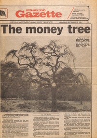 Whitehorse Historical Society Inc.
Newspaper - Article, The Money Tree, 12/09/1984 12:00:00 AM
The article describes the decision to move an 80 year old weeping elm tree from Mitcham Road to Campbell's Croft Reserve. The removalist cost of $17,000 raised some objections from local residents. The tree was valued at $100,000 in 1984, described as an outstanding example displaying perfect form and a good size - one of the largest in Victoria.fell, les, trees, campbells croft, city of nunawading, brandenburg, john p -
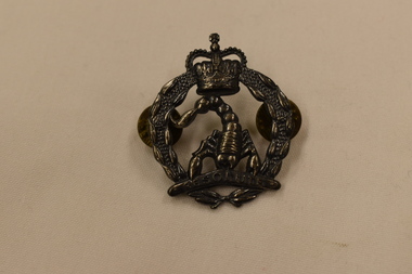 Dandenong/Cranbourne RSL Sub Branch
Hat Badge, Between 1980 & 1984
Hat badge 3rd Cavalry Armoured Corps Regiment. Antique silver hat badge Army Reserve. Circular badge in the shape of a wreath with St Edwards Crown above. Under the crown and within the wreath is a scorpion aligned with it's head and claws at the bottom of the badge. Between it's claws it is holding a boomerang embossed with the motto "Resolute".3rd Cavalry Regiment Oceania: Australia accession Number REL 25016. -
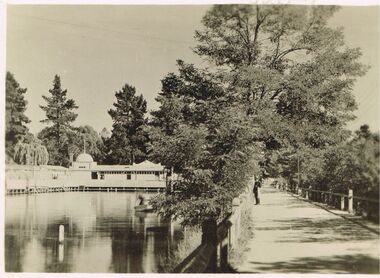 Bendigo Historical Society Inc.
Photograph - DAWN SMITH COLLECTION: PHOTOS OF BENDIGO, c1929
Dawn Smith Collection. Another Black & White Photograph of Baths at The Upper Reserve Bendigo c1929, which changed its name to The Queen Elizabeth Oval (QEO) in the 1950s to commemorate the coronation of Queen Elizabeth II. A small punt glides ably along observed by a solitary onlooker dressed in dark suit and hat carrying a towel.Souvenir Photograph Set Bendigo ? Rose Collectionbendigo, tourism, the upper reserve bendigo (qeo) -
 Bendigo Historical Society Inc.
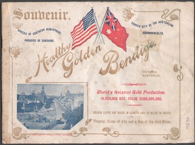
Booklet - Souvenir booklet
BHS CollectionSouvenir booklet detaining many Bendigo buildings, parks and reserves, mining and streetscapes (notably of Charing Cross and Pall Mall). The booklet was presented to visiting American Fleet on 2 Sept.1908. Cover printed in colour to highlight the American flag and Australian Naval flag. Body of the booklet contains one-page photographs of buildings and streetscapes of Bendigo.bendigo buildings, parks and reserves, mining and streetscapes -
Melbourne Tram Museum
Pamphlet, Melbourne & Metropolitan Tramways Board (MMTB), "Grand Football Match & Band Performance", 1946
Grand Football Match & Band Performance Fire Brigade v Tramways Richmond City Reserve Sunday 14 July 1946 Pamphlet advertising event and Gala Ball at Melbourne Town Hall. Handwritten note with tram times from Swan St & Church St to North Richmond. Note signed "Dist Supt SS"trams, tramways, instructions, football, richmond, swan st, church st -
 Ballarat Tramway Museum
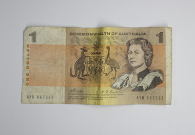
Currency - Australian One Dollar Note, Gordon Andrews, 1966-1984
Circulated between 1966 and 1984, the one dollar bank note was issued following Australia's switch to decimal currency. It was later replaced by the dollar coin. Legal tender throughout the Commonwealth of Australia and the territories of the Commonwealth. Issued by the Reserve Bank of Australia, with the signatures of both the Governor of the Reserve Bank (J.G.Phillips), and the Secretary to the Treasury (R.J.Randall) noted on the obverse. Australian one dollar notes carry individual serial numbers.Demonstrates the one dollar note as it was circulated in Australia between 1966 and 1984. It represents currency used by Ballarat passengers to pay their tram fares, and received by SEC Ballarat Tramway crews/staff in wage packets.Orange, yellow and brown minted note on white treated paper. The obverse depicts Queen Elizabeth the II, the Australian Coat of Arms and the "1" denoting value. The reverse depicts Aborginal drawings, including animals and people, as well as the "1".btm, cash, bank notes, australian currency, ballarat tramway museum, australian one dollar note -
 Ringwood and District Historical Society
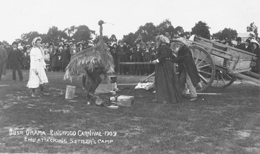
Photograph, Ringwood Show and Carnival, 1909. Opening of Mechanics Institute
Black and white photograph (2 copies- 1 small, 1 larger)Printed onto photograph: "Bush drama. Ringwood Carnival, 1909. Emu attacking settler's camp." Typed below large copy: "Carnival for opening of Mechanics Institute held on Old Ringwood Reserve (later developed as Eastland site) - 1909." -
 Ringwood RSL Sub-Branch
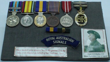
Medal - Assorted Vietnam medals, Vietnam medals
Group of 6 Vietnam era medals complete with shoulder title for RA Sigs.Australian Active Service medal clasp Vietnam. Logistics support medal. Reserve force decoration. National medal. Australian Defence medal and Efficiency decoration with 2 clasps QE11. 3166251 J.D. Mather complete with photograph of Major Mather. -
 City of Kingston
Photograph - Black and white, 20 December 1945
This aerial photograph depicts the changing landscape of Cheltenham and Highett since WWII. Photographed in 1945, there is a mix of urban dwellings and industrial development and precedes the major transformation of Cheltenham with the development of the Southland shopping centre in the 1960s and expansion in the 1990s.A large part of Cheltenham was originally established as a rural market gardening community. The railway line and station brought urban development to the area and in the north, the Highett area was dominated by the Highett Gas Works. Cheltenham became a major destination for shopping in the 1960s with the opening of Southland.Aerial photograph taken in 1945 of Cheltenham and Highett within the City of Kingston. The image includes the Highett Reserve, (top right), the Methodist Children Homes (now Southland), Nepean Highway and Jamieson Street. Highett Gas Works is visible in the top left and the land now named William Fry Reserve at the intersection of Bay Road and Nepean Highway. A visible large parcel of land on the corner of Bay Road and Nepean Highway was developed in the 1990s as the west side addition to Southland. The densely vegetated area in the upper right sector of the image is now dense with housing. Tulip Grove, Heather Grove and Gilford Street are visible bottom left. This image is possibly from the collection of aerial photographs commissioned by the Department of Crown Lands and Survey and taken by Adastra Airways.Black ink: 57252 White lettering: VIC-10 57252 20.12.45 [lens information indecipherable] PROJ. No.5 MELB. METROP AREA Black pencil: 80highett, cheltenham, highett gas works, urbanisation -
 City of Kingston
Photograph - Black and white, 20 December 1945
This aerial photograph depicts the changing landscape of Cheltenham and Highett since WWII. Photographed in 1945, there is a mix of urban dwellings and industrial development and precedes the major transformation of Cheltenham with the development of the Southland shopping centre in the 1960s and expansion in the 1990s.A large part of Cheltenham was originally established as a rural market gardening community. The railway line and station brought urban development to the area and in the north, the Highett area was dominated by the Highett Gas Works. Cheltenham became a major destination for shopping in the 1960s with the opening of Southland.Aerial photograph taken in 1945 of Cheltenham and Highett within the City of Kingston. The image includes the Highett Reserve, (top right), the Methodist Children Homes (now Southland), Nepean Highway and Jamieson Street. Highett Gas Works is visible in the top left and the land now named William Fry Reserve at the intersection of Bay Road and Nepean Highway. A visible large parcel of land on the corner of Bay Road and Nepean Highway was developed in the 1990s as the west side addition to Southland. The densely vegetated area in the upper right sector of the image is now dense with housing. Tulip Grove, Heather Grove and Gilford Street are visible bottom left. This image is possibly from the collection of aerial photographs commissioned by the Department of Crown Lands and Survey and taken by Adastra Airways.Black type: Reverse lettering VIC-10 57252 20.12.45 [lens information indecipherable] PROJ. No.5 MELB. METROP AREA White lettering: Reverse writing 57252cheltenham, highett, highett gas works, urbanisation