Showing 2476 items matching " township"
-
 Glenelg Shire Council Cultural Collection
Souvenir - Souvenir Envelope, 1984
Two Australia Post souvenir envelopes - Victoria's 150th anniversary (Portland. First settlement). Cream coloured, envelope, full colour design on front of envelope shows Edward Henty, view of township, thistle, pier and council logos. Reverse has shows 150th.australia post, souvenir, victoria 150th -
 Bendigo Historical Society Inc.
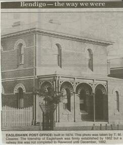
Newspaper - JENNY FOLEY COLLECTION: EAGLEHAWK POST OFFICE
Bendigo Advertiser ''The way we were'' from 2000. Eaglehawk post office: built in 1874. This photo was taken by T. M. Cleaves. The township of Eaglehawk was firmly established by 1862 but a railway line was not completed was not completed to Raywood until December, 1882. The clip is in a folder.newspaper, bendigo advertiser, the way we were -
 Bendigo Historical Society Inc.
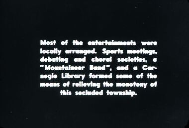
Slide - DIGGERS & MINING. DIGGERS AND MINERS, 1850s
Diggers & Mining. Diggers and Miners. Most of the entertainments were locally arranged. Sports meetings, debating and choral societies, a 'Mountaineer Band', and a Carneigie library formed some of the means of relieving the monotony of this secluded township. Markings: 50 994.5 WAL. Used as a teaching aid.hanimounteducation, tertiary, goldfields -
Bendigo Historical Society Inc.
Map - HUNTLY : COUNTY OF BENDIGO, August 1954
Map. Huntly, County of Bendigo. Whirrakee, Bagshot, Wellsford, Nerring, Neilborough, Township of Huntly. Drawn and reproduced at the Department of Lands and Survey, Melbourne, Victoria. August 1954. Price 2/-. By authority W.M. Houston, Government Printer. (number 42 in map cupboard 1)W.M. Houston, Govt. Printer.map, bendigo, huntly -
 Bendigo Historical Society Inc.
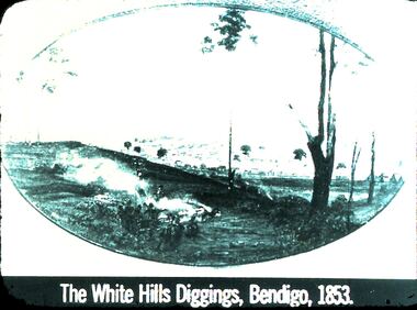
Slide - DIGGERS & MINING: THE DIGGINGS - THE DIGGERS
Diggers & Mining: The Digging - The Diggers. Slide depicts: The White Hills Diggings, Bendigo, 1853. Shows aborigines sitting on near side of hill. Over the hill in the back ground is a small township forming. Markings: 22 994.LIF:6. Used as a teaching aid.hanimounteducation, tertiary, goldfields -
 Bendigo Historical Society Inc.
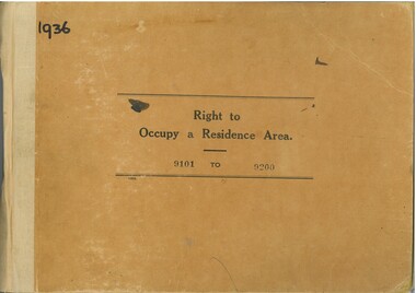
Administrative record - Right to Occupy Certificates, 1936
Twelve books containing stubs of Right to Occupy Certificates for 1936. Includes name and address of person receiving the Right to Occupy certificate and the description of the land including allotment, Section, City, Town, Borough or Township and Parish name. List of record Numbers in Box 906 Some items have pencil and pen marks and ink stains.right to occupy, central victoria -
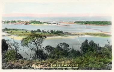 Lakes Entrance Historical Society
Postcard - Bullock Island, Bulmer H D, 1920c
Hand coloured postcard of Bullock Island and the man made entrance from Bass Strait to the Gippsland Lakes. Also shown the small township, unofficially known as Carpentertown at the entrance works. Photo taken from Kalimna Hill, shrubbery in foreground. Lakes Entrance VictoriaBullock Island, Lakes Entrancewaterways, bridges, islands, jetties -
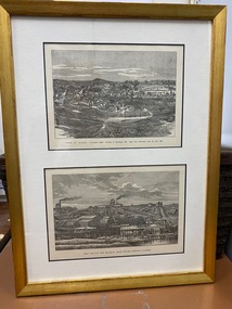 Clunes Museum
Print, R GROSSE
.1 TWO PRINTS, ONE ABOVE THE OTHER, COPIED TO BUFF COLOURED PAPER, MOUNTED IN GOLD COLOURED TIMBER FRAME. PRINTS TAKEN FROM LITHOGRAPHS .2 FRAMED COLOUR PRINT OF TOWNSHIP OF CLUNES APPROX 1890'S. SAME AS TOP IMAGE OF .1TOP IMAGE PRINTED IN BLACK: TOWN OF CLUNES - POPULATION 4874 NUMBER OF BUILDINGS 1100 GOLD FIRST DISCOVERED HERE Ist JULY 1851 BOTTOM IMAGE PRINTED IN BLACK: PORT PHILLIP AND COLONIAL GOLD MINING COMPANY CLUNESport phillip mine, township of clunes -
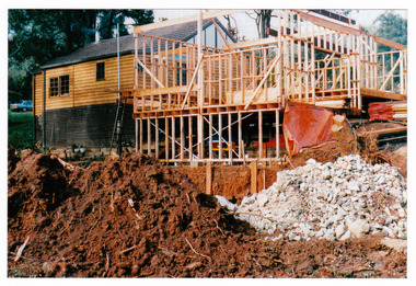 Marysville & District Historical Society
Photograph (Item) - Colour photograph, Unknown
A colour photograph taken during the construction of Arbor Green Cottage in Marysville. This cottage, along with most of the buildings in the township, was destroyed in the 2009 Black Saturday bushfires.A colour photograph taken during the construction of Arbor Green Cottage in Marysville.1 Falls Rd M'sville./ The future ahead./ The Arbor Green Galleries/ 3 Levels.marysville, victoria, australia, photograph, accommodation, arbor green cottage, 2009 black saturday bushfires -
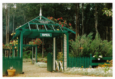 Marysville & District Historical Society
Photograph (Item) - Colour photograph, 1992
A colour photograph of the garden entrance and bridge at Arbor Green Gardens in Marysville. This cottage, along with most of the buildings in the township, was destroyed in the 2009 Black Saturday bushfires.A colour photograph of the garden entrance and bridge at Arbor Green Gardens in Marysville.Garden Entrance & bridge./ Arbor Green Galleries/ 1 Falls Rd. M'sville./ Spring 1992marysville, victoria, australia, photograph, accommodation, arbor green cottage, 2009 black saturday bushfires -
 Marysville & District Historical Society
Photograph (Item) - Colour photograph, Unknown
A colour photograph of the front facade and garden of Arbor Green Galleries in Marysville. This cottage, along with most of the buildings in the township, was destroyed in the 2009 Black Saturday bushfires.A colour photograph of the front facade and garden of Arbor Green Galleries in Marysville.1 Falls Rd M'sville./ Arbor Green Galleries & Cottage.marysville, victoria, australia, photograph, accommodation, arbor green cottage, 2009 black saturday bushfires -
 Marysville & District Historical Society
Photograph (Item) - Colour photograph, 1992
A colour photograph of the front pergola at the entrance to Arbor Green Galleries in Marysville. This cottage, along with most of the buildings in the township, was destroyed in the 2009 Black Saturday bushfires.A colour photograph of the front pergola at the entrance to Arbor Green Galleries in Marysville.1 Falls Rd M'sville./ Arbor Green Galleries & Cottage.marysville, victoria, australia, photograph, accommodation, arbor green cottage, 2009 black saturday bushfires -
 Marysville & District Historical Society
Photograph (Item) - Colour photograph, Unknown
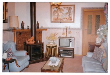
A colour photograph of the sitting room in the cottage at Arbor Green Galleries and Cottage. This cottage, along with most of the buildings in the township, was destroyed in the 2009 Black Saturday bushfires.A colour photograph of the sitting room in the cottage at Arbor Green Galleries and Cottage.1 Falls Rd. M'sville./ Cottage Sitting Room.marysville, victoria, australia, photograph, accommodation, arbor green cottage, 2009 black saturday bushfires -
 Marysville & District Historical Society
Photograph (Item) - Colour photograph, Unknown
A colour photograph of one of the cottages at Amber View Cottages in Marysville. These cottages, along with most of the buildings in the township, were destroyed in the 2009 Black Saturday bushfires.A colour photograph of one of the cottages at Amber View Cottages in Marysville.amber view cottages, marysville, victoria, australia, accommodation, photograph, 2009 black saturday bushfires -
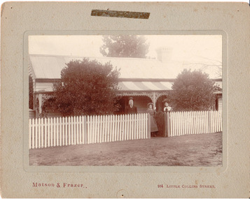 Hume City Civic Collection
Photograph, c1907
Members of the Fanning family standing outside their house 'Sunnyside', in Loemans Road, Bulla. The Fannings were one of the early European families to settle in the Bulla township. A black and white mounted photograph of the Fanning family in front of a cottage with a picket fence.Printed on face: Matson and Frazer / 264 Little Collins Street Handwritten on back: Eric Boardmanmatson and frazer, photographers, eric boardman collection, fanning family, george evans collection -
 Orbost & District Historical Society
black and white photograph, 1924
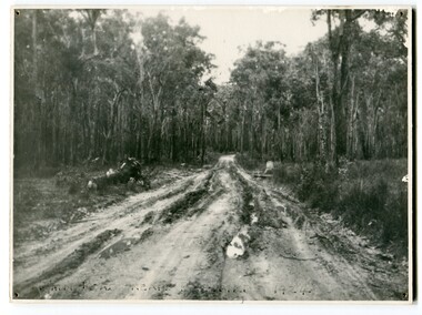
This photograph shows the main road near Bellbird, East Gippsland, in 1924. This road would have been the Princes Highway, a main thoroughfare through to New South Wales. Bellbird Creek is a small rural location between Orbost and Cann River. There was no township at Cabbage Tree at this time. The Cabbage Tree Creek township was established to support the booming timber industry of the mid 20th century. Five timber mills worked full time supporting the families that were drawn to the area's wealth of natural resources. Nestled on the banks of the Cabbage Tree Creek, the township was built by those mills to house their workers. Today although the timber mills have disappeared, some of the buildings still remain. Little now remains to remind of the saw-milling history apart from photographs and some relics - a boiler and a brick furnace. There was also a thriving agricultural community farming dairy, beef, seed beans and fresh peas and beans that were sent to the Victoria Market in Melbourne. Dairy farming still plays an essential role in the township. this is a pictorial record of the Princes Highway, the main road from East Gippsland to the New South Wales border.A large black / white photograph of a very wet and boggy bush road.on front - "Main Rd near Bellbird 1924"road princes-highway bellbird-creek-1924 -
 Orbost & District Historical Society
black and white photographs, 1974 - 1976
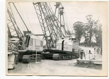
Construction of the roadway embankment between the bridges across the Snowy River flood plains at Orbost commenced in January 1974 and was completed in November 1976. Pearsons were the bridge contractors for the construction of the Princes Freeway and bridges across the river flood plains at Orbost. Heavy rains and floods held up progress.These photographs are of the construction of a major structure in Orbost. The opening of this Snowy River Bridge was an important development in the accessibility to the township of Orbost.Four black / white photographs of construction sites. 3241.1 is of three cranes and other machinery with six persons. 3241.2 is of workmen working on flooded site. 3241.3 is a photograph of the early stages of construction of a bridge looking towards the township. 3241.4 shows the construction of a roadway between the bridges.construction-snowy-river-bridge bridge-orbost -
 Orbost & District Historical Society
black and white photographs, March 10 1961
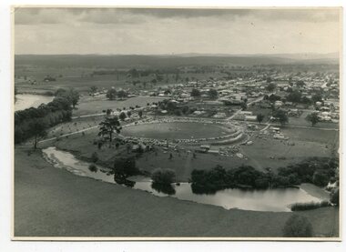
These photographs are pictorial record of Orbost in 1961.They enable us o observe the objects in their spatial context and in detail. They are useful for reference.Four black / white aerial photographs. there are spare copies of each. 3276.1 is an aerial photograph of the Orbost Show with Lochiel Park in the foreground. 3276.2 is an aerial photograph taken over a township. 3276.3 shows the Orbost High School on the left. 3276,4 shows the high school in the foreground.on the back of each is "March 10th 1961 Aerial of Orbost"photographs-aerial-orbost-1961 orbost-1961 lochiel-park -
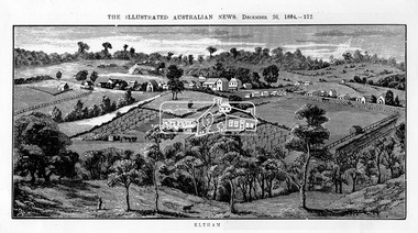 Eltham District Historical Society Inc
Photograph, Samuel Calvert, Eltham, The Illustrated Australian News, December 26, 1884, p212, 1884
A description in the newspaper near the illustration (page 210) reads as follows: "Eltham is a pretty little township on the Yarra Flats road, about 14 miles east north east of Melbourne, from which place there is communication by way of Heidelberg. It has a population of nearly 400 inhabitants, but in addition it is the centre of a large district extending over about 203 square miles, having a population of 2344. The land in the district is mostly used for grazing purposes, although as a rule the small farms grow a good deal of wheat, oats and other agricultural produce. A large quantity of fruit, especially raspberries and strawberries, is also produced, the rich alluvial flats along the creek upon which the township is situated being very well adapted for that purpose. Gold has also been found in the vicinity of the township, but not in remunerative quantities". This photo forms part of a collection of photographs gathered by the Shire of Eltham for their centenary project book,"Pioneers and Painters: 100 years of the Shire of Eltham" by Alan Marshall (1971). The collection of over 500 images is held in partnership between Eltham District Historical Society and Yarra Plenty Regional Library (Eltham Library) and is now formally known as 'The Shire of Eltham Pioneers Photograph Collection.' It is significant in being the first community sourced collection representing the places and people of the Shire's first one hundred years.Digital imageshire of eltham pioneers photograph collection, eltham, illustrated australian news -
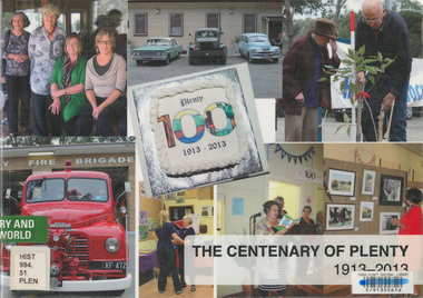 Eltham District Historical Society Inc
Book, The Centenary of Plenty 1913-2013, 2014
Published to commemorate the centenary of the township of Plenty in the Shire of Nillumbik in 2013. It includes photos and information about the centenary celebrations and brief histories of various community groups in Plenty.plenty (vic.), centenary -
 Eltham District Historical Society Inc
Negative - Photograph, J.A. McDonald, Heidelberg-Kinglake Road, Sep. 1960
Looking north from south boundary of St Andrews Township (Cr. Brinkkotter in car) Noted on album page as September 1960 but photo dated October on reverseRecord of various Shire of Eltham infrastructure works undertaken during the period of 1952-1962 involving bridge and road reconstruction projects, sometimes with Eltham Shire Council Project Reference numbers quoted. It was during this period that a number of significant improvements were made to roads and new bridges constructed within the shire that remain in place as of present day (2022). In many situations, the photos provide a tangible visible record of infrastructure that existed throughout the early days of the Shire. The album was put together by or under the direction of the Shire Engineer, J.A. McDonald.infrastructure, shire of eltham, bridge construction, road construction, cr. a. brinkkotter, heidelberg-kinglake road, st andrews, 1960-09 -
 Marysville & District Historical Society
Photograph (Item) - Colour photograph, Unknown
A colour photograph of one of the cottages at Amber View Cottages in Marysville. These cottages, along with most of the buildings within the township, were destroyed in the 2009 Black Saturday bushfires.A colour photograph of one of the cottages at Amber View Cottages in Marysville.amber view cottages, marysville, victoria, australia, accommodation, photograph, 2009 black saturday bushfires -
 Marysville & District Historical Society
Photograph (Item) - Colour photograph, 1986
A colour photograph of the timber worker's cottage that became Arbor Green Cottage in Marysville. This cottage, along with most of the buildings in the township, was destroyed in the 2009 Black Saturday bushfires.A colour photograph of the timber worker's cottage that became Arbor Green Cottage in Marysville.1 Falls Rd M'sville Spring 1986./ Rear cottage./ To become/ Arbor Green Cottage.marysville, victoria, australia, photograph, accommodation, arbor green cottage, 2009 black saturday bushfires -
 Marysville & District Historical Society
Photograph (Item) - Colour photograph, 1986
A colour photograph of the timber worker's cottage that became Arbor Green Cottage in Marysville. This cottage, along with most of the buildings in the township, was destroyed in the 2009 Black Saturday bushfires.A colour photograph of the timber worker's cottage that became Arbor Green Cottage in Marysville.1 Falls Rd M'sville./ Timber workers cottage/ To become Arbor Green Cottage./ Spring 1986.marysville, victoria, australia, photograph, accommodation, arbor green cottage, 2009 black saturday bushfires -
 Marysville & District Historical Society
Photograph (Item) - Colour photograph, Unknown
A colour photograph of the main building and entrance gate to Arbor Green Galleries in Marysville. This cottage, along with most of the buildings in the township, was destroyed in the 2009 Black Saturday bushfires.A colour photograph of the main building and entrance gate to Arbor Green Galleries in Marysville.Arbor Green Galleries./ 1 Falls Rd M'sville./ Side approach.marysville, victoria, australia, photograph, accommodation, arbor green cottage, 2009 black saturday bushfires -
 Marysville & District Historical Society
Photograph (Item) - Colour photograph, Unknown
A colour photograph of the rear of the main building and garden at Arbor Green Galleries in Marysville. This cottage, along with most of the buildings in the township, was destroyed in the 2009 Black Saturday bushfires.A colour photograph of the rear of the main building and garden at Arbor Green Galleries in Marysville.Arbor Green Galleries./ 1 Falls Rd M'sville./ Rear aspectmarysville, victoria, australia, photograph, accommodation, arbor green cottage, 2009 black saturday bushfires -
 Marysville & District Historical Society
Photograph (Item) - Colour photograph, 1986
A colour photograph of the timber worker's cottage that became Arbor Green Cottage in Marysville. This cottage, along with most of the buildings in the township, was destroyed in the 2009 Black Saturday bushfires.A colour photograph of the timber worker's cottage that became Arbor Green Cottage in Marysville.1 Falls Rd M'sville./ Spring 1986./ Timber workers cottage/ To bcome Arbor Green Cottagemarysville, victoria, australia, photograph, accommodation, arbor green cottage, 2009 black saturday bushfires -
 City of Kingston
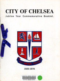
Booklet - Commemorative book, City of Chelsea, City of Chelsea Jubilee Commemorative Booklet, 1970
In 1920 the City of Chelsea was formally proclaimed to be a city, rather than a township. This booklet, produced in 1970 was to commemorate it being 50 years since Chelsea was proclaimed a city.Five (5) page booklet with white cardboard covering with black text at top and bottom and a blue and red coat of arms for the City of Chelsea in the centre. The book was, at one time, registered with the Kingston Library Service and has a barcode and green sticky dot adhered to the front. There are two holes punched into the left hand side of the booklet with a royal blue ribbon threaded through and connected with a bow.chelsea, proclamation, city -
 Greensborough Historical Society
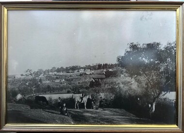
Photograph - Photograph (Framed), From Willis Vale to Greensborough 1889, 1889
A view of Greensborough township from Willis Vale, home of the Partington family. Taken on the day of Ellen Whatmough's funeral, this photograph shows both Eva and William Partington.From the John Mackey collection. this item was displayed at the offices of Ryan, Mackey and Kelly, solicitors, Main Street Greensborough.Timber-framed photograph of view of Greensborough, black and white.greensborough, john mackey, partington family, ellen whatmough -
 Eltham District Historical Society Inc
Folder, Short History of the Municipality of Eltham, 1981
Document from unknown author. Sections include: Constitutional history, population growth including ABS data 1943- 1978, notes on the European history of Eltham - about your Council - schools - list of historical buildings. Copy also held at Yarra Plenty Regional Library (Eltham Library). Possibly produced as a resource for students. Also includes single page headed Heritage Week 1983, rural townships, page 3 with refernece to key buildings in Eltham township.30 pages, typed textHG Booklet 17harry gilham collection, pioneers of eltham, population, shire of eltham