Showing 1662 items
matching george hill
-
 Clunes Museum
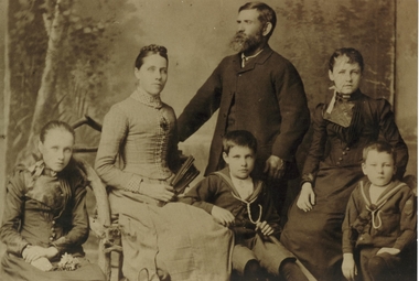
Photograph
PEOPLE IN THIS PHOTOGRAPH ARE JOHN & LOUISA SWAINSON (NEE WORLEY) WITH CHILDREN ETTIE, KATE, GEORGE & PERCY. SWAINSON FAMILY HOME WAS IN HILL STREET, CLUNES.1 SEPIA PHOTOGRAPH OF SWAINSON FAMILY GROUP .2 TOGETHER WITH A PHOTO COPY OF SAME.local history, photographs, swainson family group, worley -
 Box Hill Historical Society
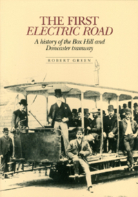
Book, Green, Robert, The First Electric Road - A History of the Box Hill and Doncaster Tramway
This book gives a brief description of tramways around the world before focussing on Box Hill-Doncaster's very own. The tramway - the first electric one in the Southern Hemisphere - operated from 1889-1896. It ran from Whitehorse Road along Station Street north to Doncaster Road Intersection. Photos. Index.arnot> arthur, draper> thomas, laurie> david, meader> william, masters> william, serpell> richard, glassford> matthew, aspinall> joseph w., cockcroft> george, collier> samuel, ellingworth> william, inglis> john, mcmurdie> f.a., padgham> silas, rawlings> alfred, serpell> alfred, wright> george, wright> james, wright> john, wright> william edward, lauer> a.c.h., transport, tram services, station street, box hill, elgar road, doncaster, doncaster road, box hill and doncaster tramway company -
 Nillumbik Shire Council
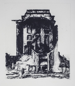
Print (drypoint): Rick AMOR (b.1948 Melbourne, AUS), Rick Amor, 'The Ruin' from 'The Baldessin & Friends' commemorative folio, 2016
Painter, printmaker and sculptor Rick Amor is one of Australia's most distinguished senior artists. He was a good friend of the late George Baldessin and three times Archibald Prize winner Clifton Pugh, having lived and worked at Pugh's property, Dunmoochin in Cottles Bridge, Nillumbik during the 1980s and 90s. George Baldessin (1939-1978) was born in San Biagio di Callalta, in the Veneto in Northern Italy and arrived in Australia ten years later. A printmaker and sculptor he built his bluestone studio at St Andrews (Nillumbik) in 1971 with his partner Tess and the three Hails brothers, Rob, Doug and Don. Made of recycled materials the studio today contains all of George’s equipment including the large press, which he modelled himself with the help of Neil Jeffrey (Enjay Presses). George won many prizes throughout his career and is represented in many of Australia's public art collections including his famous 'Pears' sculpture in front of the National Gallery of Australia, Canberra. In 1975 he represented Australia in the Sao Paulo Biennale, before living and working in Paris until his return to St Andrews in 1977. In 1978 George was killed in a car accident aged 39 years. In 2001 Tess returned to St Andrews to reclaim the run-down studio and reconstitute it as The Baldessin Press & Studio - a printmaking retreat. It operates in George’s memory, so that artists may continue to create, perpetuating the generous spirit of George. 'The Ruin' is one of eight prints in the 'Baldessin & Friends commemorative folio. The folio was conceived by Tess Edwards as a fundraising initiative in celebration of the The Baldessin Press & Studio's fifteen year anniversary, and as a way to honour George Baldessin's memory. The folio is a unique coming together of seven very different and acclaimed artists who are connected by their friendship to the missing eighth member, George Baldessin. The Baldessin Press & Studio is a not-for-profit organisation created in memory of the late George Baldessin (1939-1978), whose original studio is now open to the public for creative use and as a practical legacy to living artists. The Studio is located in St Andrews, Nillumbik. Rick Amor has been an ardent supporter of the Baldessin Press & Studio and a great patron of living artists. In 2014 the Press partnered with Amor and the State Library of Victoria to create The Amor Residency at The Baldessin Press & Studio, which is part of the Library's annual fellowship program. 'The Ruin' was based on a plein air painting done by Rick Amor on a trip to Broken Hill in 2001 and reflects on death and the passing of time so eloquently portrayed by the industrial ruins of NSW. In the tradition of a Piranesi, the work emphasises the transience of life and the triumph of time. Black and white drypoint etching in which a small figure, a traveller; located bottom left, points to a large crumbling edifice (building), a stage like space in the background. Ed.14/25baldessin, print, drypoint, amor, 2018 ekphrasis, ruin, etching, ekphrasis2018 -
 Brighton Historical Society
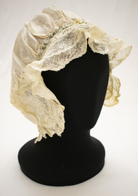
Bonnet, circa 1900s
This bonnet is part of a collection of clothing donated to the Brighton Historical Society by Dr William and Helen Wells. It is believed to have belonged to William's grandmother Winifred Marshall (nee Hayball, 1886-1971). William's family has had a long association with Brighton, dating back to the town's earliest days in 1843 when his ancestors Robert and Eliza Hayball, who had emigrated to Melbourne two years prior, established a wattle-and-daub hut in what is now New Street, close to Tovell Street. Robert established a business as a timber merchant on the opposite side of New Street. His sons, Robert, William and Edwin took over the firm following his retirement, trading as the Hayball Bros. Hayball Court, which runs off New Street, is named after the family. Robert's son William (1855-1926) married Jessie Robertson and had four children. Their eldest, Winifred Grace Hayball (1886-1971), married Andrew Hollingsworth Marshall at the Black Street Congregational Church in 1907. They subsequently lived in Hill Street, Hawthorn, before moving into a house designed by Andrew and Winifred's brother Robert at 39 Bay Street, Brighton in 1915. Their daughter, Dorothy Marshall (1910-2000) married Robert George (Argie) Wells in 1937 at Wesley College Chapel. They lived in East Malvern until 1947, when they moved into a newly built home in Hawthorn Road, East Brighton, where they lived for the rest of their lives. Their son, William Wells (b. 1939) married Helen Pickering in 1968 and the couple have lived together in Brighton ever since.Pale pink silk bonnet (sleeping or house cap) with cream lace edging. The bonnet is embellished with oval-shaped embroidered appliqué on either side, featuring floral design in white and pale yellow, blue and green. A cream silk ribbon and a row of pale blue and green rosettes run along the top edge between the two appliquéd segments. A length of elastic is sewn through the bottom edge.wells family, winifred grace hayball, winifred grace marshall, bonnet, 1900s -
 Swan Hill Regional Art Gallery
Painting, O'CONNOR, Victor George, Pigeons Florence, unknown
-
Swan Hill Regional Art Gallery
Painting, RATHBONE, George, Log loading station on the Murray river, 1978
-
 Stawell Historical Society Inc
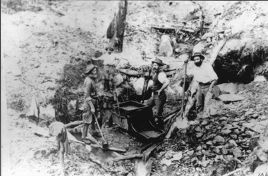
Photograph, Mining Scene at Quartz Reefs, St Georges Lead. Three miners with a gold rocking cradle
Miners around Big Hill area at work St Georges Lead c 1860's. Note gold rocking cradle. This photo was amongst several mining photos, all of which were identified and catalogued under their correct mine name in 2010-2011.Three men with shovels around a gold mine cradle on a rocky hill side.stawell -
 Stawell Historical Society Inc
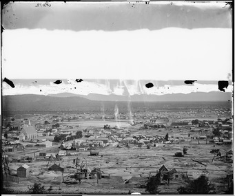
Photograph, View of Stawell from Big Hill April 1874 showing mines centered on St Georges Crushing Mill -- 5 Photos
From left Reefs Restaurant, T. Hogan & Co Tea Wine Spirits Merchant, R. Hepburn Carolina Hotel, Pleasant Creek Hotel, St George Stamping Battery, Free Methodist Chapel Church, Ballarat Hotel, Woodcock Produce Grocer, Stawell Brewery in far distance, L. Thomas Wheelwright Farrier & General Blacksmith, Australian Hotel, G. Laing Bootmaker, Brierly & Wilson Greengrocer, P. Corkeron Bootmaker, P. Corkeron Wholesale Retail General Grocer, Globe Hotel in distance, Christ Church.Part of Holtermann Collection. Black and White photograph of Stawell from Big Hill with mining in foreground. April 1874. View covers from St Patrick's Church to current location of Police Station along Patrick Street. St George Crushing Mill near Centre of Photograph. Includes Carolina Hotelmining, panorama -
 National Wool Museum
Photograph
... the following year. Russell Mr George - Clyde Company 'Golf Hill ...Photo depicts Golf Hill, Shelford. Golf Hill was the estate of George Russell (1812-1888), the manager (from 1836) of the pastoral Clyde Company (a joint stock concern originally formed in Scotland). Russell's youngest daughter, Janet Biddlecombe (b. 1866) died in 1954 and part of the estate was subdivided and sold the following year.Krickeldorff / Melbournerussell, mr george - clyde company, 'golf hill' station, geelong -
Whitehorse Historical Society Inc.
Article, Council service stands out, 1994
One hundred and thirty-five men and women have served the City of Nunawading and before that the Shire of Blackburn and Mitcham.One hundred and thirty-five men and women have served the City of Nunawading and before that the Shire of Blackburn and Mitcham. Present and past councillors recall major achievements on the eve of amalgamation with Box Hill.One hundred and thirty-five men and women have served the City of Nunawading and before that the Shire of Blackburn and Mitcham.local government, city of nunawading, shire of blackburn and mitcham, councillors, sutherland, leslie j, riddell, arthur, rooney, keith, cox, george, oakley, gavan, barelli, ken, plummer, jan, atkinson, bruce, athan, savvas, smith, dorothy g, allan, peter, spurr, noel -
Whitehorse Historical Society Inc.
Document, Early hotels in Nunawading
Information copied from Cole Collection of Hotel records in La Trobe Library giving information on Blackburn Travellers rest, Mitcham Reserve Hotel, Emeries Hotel, Hill Hotel, Royal Hotel, Harvest Home, Harkaway Inn, Delaneys, Surrey Hill, Royal Hotel.alchard, mcstone, pearce, m.a., o'callaf, mary jane, mcglone, john, burrell, delaney, denis, humberstone, william, humberstone, c, hotels, travellers rest hotel, king george hotel, mitcham, reserve hotel, mitcham, emerie's hotel, mitcham, hill hotel, mitcham, royal hotel, harvest home hotel, harkaway inn, east burwood, delaney's hotel, surrey hills, royal hotel, surrey hills -
 Whitehorse Historical Society Inc.
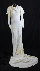
Clothing - Wedding Dress, 1936
Donated by grand daughter of Edith and Ron Palmer. Bride Ellen Lidgerwood married Ron Mathers on 4 September 1937.The Best Man was the brother of the Groom, George Mathers. The bridesmaid was the sister of the groom, Miss Mathers and the flower girl was the niece of the bride, June Lidgerwood. For full family history and photos of both weddings see Supplementary File NA3817 & NA3818. Dress worn by Ellen at her wedding and Veil worn by both sisters Edith and Ellen Lidgerwood at their wedding ceremonies, Edith in 1936 (see NA3817) and Ellen in 1937Prominent Box Hill families1937 cream seersucker dress featuring a cowl neck and long sleeve, slit at shoulder to create cowl effect. Slim at lower arm to a point over the hand and fastened at seam with press stud. Bodice cut on the cross under the bust. Cut on the cross figure fitting skirt to the floor, complete with long train. On the back is a slit opening fastened with hook and eye and glass clear buttons. Below the slit are eight glass buttons with false rouleau button loops. The train is made of an added detachable piece. Veil worn at both sisters weddings but with different headdresses. Headdress has small circle of flowers and berries. See sister's wedding dress NA3817.costume, female ceremonial -
Whitehorse Historical Society Inc.
Document, George Randolph Henwood, 2006
... of George Randolph Henwood at Salvation Army Box Hill. George ...Program of thanksgiving celebration for the life of George Randolph Henwood at Salvation Army Box Hill.Program of thanksgiving celebration for the life of George Randolph Henwood at Salvation Army Box Hill.Program of thanksgiving celebration for the life of George Randolph Henwood at Salvation Army Box Hill.henwood, george -
 Whitehorse Historical Society Inc.
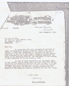
Legal record - Correspondence, Public Open Spaces, 24/12/1929 12:00:00 AM
Letter from H.T. Bishop, Shire Secretary, Shire of Blackburn and Mitcham to Mr Geo. Morton requesting valuation of landLetter from H.T. Bishop, Shire Secretary, Shire of Blackburn and Mitcham to Mr Geo. Morton requesting valuation of land for sale for the Parks and Gardens Committee, dated 24 / 12 / 1929. Valuations provided by Geo. Martin dated 6/ 1 / 1930.Letter from H.T. Bishop, Shire Secretary, Shire of Blackburn and Mitcham to Mr Geo. Morton requesting valuation of land land values, shire of blackburn and mitcham, bishop, herbert thomas., morton, george, main street, blackburn, gardenia street, husband road, forest hill, surrey road, holland road, blackburn south, canterbury road, whitehorse road, nunawading, glendale street, williams road, south parade, tunstall -
 Whitehorse Historical Society Inc.
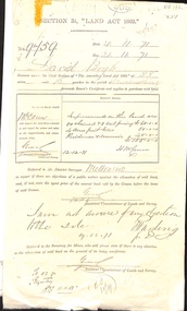
Correspondence, David Boyle's Land, 01/07/1868
Three documents related to David Boyle's land (Mount Pleasant) now in Forest Hill. (a) Application for a license to occupy. 29 July 1868. (b) Application to purchase land. 21 November 1871. (c) Letter requesting to delay purchase, written by G.A. Goodwin (Solicitor). Photocopies.boyle, david, goodwin, george augustus, mount pleasant, forest hill, orchards, land settlement -
 Whitehorse Historical Society Inc.
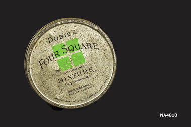
Container - Cigarette Tin
Donated by Box Hill Historical SocietyRound grey coloured with silver coloured lid (badly pitted). Printing on tin 'Dobies Four Square (overprinted on design of 4 green squares 2 top 2 bottom). Mixture'. Under green squares- Regd Trade Mark. Under word mixture- Empire Deluxe' George Dobie and sons Ltd Paisley Scotland'. Around rim of tin lid 'Manufactures of quality tobacco since 1809' Base of tin Made in Scotland with 2ozs net between made in and Scotland.Made in Scotland 2ozs netcontainers, domestic -
 Whitehorse Historical Society Inc.
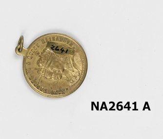
Medal, 1937
Given to donor at Box Hill State School. All school children throughout Australia were given this medallion on the coronation of George VIGold plated medallion with crowned heads of George V1 and Queen Elizabeth on reverse face, Victoria's Coat of Arms. Inscription around both edges. Small loop for chain or pin.To commemorate Their Majesties coronation May 12th 1937.|King George V1 and Queen Elizabeth.numismatics, medals - commemorative -
Whitehorse Historical Society Inc.
Document - Illustration, George Gatter, n.d
Photocopy of photo of George Gatter, 1828 - 1886, market gardener, purchased land in Box Hill 1861.Photocopy of photo of George Gatter, 1828 - 1886, market gardener, purchased land in Box Hill 1861. First secretary , Horticultural and Agricultural Society of South Bourke.Photocopy of photo of George Gatter, 1828 - 1886, market gardener, purchased land in Box Hill 1861. gatter, george, market gardeners -
 Whitehorse Historical Society Inc.
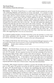
Document - Report, The Pound House, 1998
Report on The Pound House, 988 Canterbury Road, Box Hill South, by Andrew Ward, architectural historian.Report on The Pound House, 988 Canterbury Road, Box Hill South, by Andrew Ward, architectural historian. The report details the history of the site which was the first Shire Hall of the Shire of Nunawading and then the residence of the pound keeper. The building is described. Photographs. 7 pages.Report on The Pound House, 988 Canterbury Road, Box Hill South, by Andrew Ward, architectural historian. bills, annis, george, fairbanks, g, j, bennett, s, bishop, edward, bayley, leonard sherwin, blood, robert, norman & hayes, kennedy, bob, city of box hill, shire of nunawading -
 Whitehorse Historical Society Inc.
Photograph, Mrs Collier and baby George
Series of photographs loaned for copying by Robert Collier through Keith Rooney. Photographs have been scanned by Ted Arrowsmith at 300dpi as a 'tiff' and burnt onto a CD Rom. copies of photographs were produced from the CD Rom for inclusion in the album.Black and white photograph of Mrs Collier carrying Baby George Collier in front of their house on 50 acres in Canterbury Road, Forest Hill, Then Blackburn. This was site of the Nunawading High School.collier mrs, collier george, canterbury road, orchards, tunstall -
 Whitehorse Historical Society Inc.
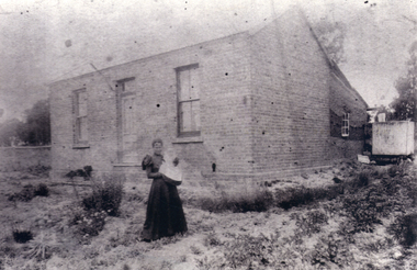
Card, 1907
Card - photo of George V and Queen Mary with British and Australian flags. 'Box Hill State School No. 2838' 'Empire Day 1907''I love God and my country ------ and the laws'documents, cards -
 Whitehorse Historical Society Inc.
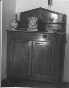
Furniture - Chiffonier
... to make way for Pacific Way, Forest Hill. Restored by George Cox... Mitcham melbourne Rescued by George Cox from an old house being ...Rescued by George Cox from an old house being demolished to make way for Pacific Way, Forest Hill. Restored by George CoxCedar chiffonier with zinc mesh sides. One drawer and two doors. Shelf supported by two pedestals. Four turned wood legs.furniture, domestic -
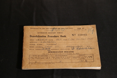 Ballarat Heritage Services
Digital photographs, L.J. Gervasoni, World War Two Demobilization Procedure Book, c1940s
Digital images of the demobiization procedure book owned by George (Gus) Gervasoniforces, adf, army, world war two, australia, australian army, defence, armed services, demobilzation, procedure, george gervasoni, gus gervasoni -
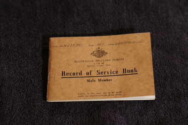 Ballarat Heritage Services
Digital photographs, L.J. Gervasoni, Australian Military Service Record of Service Male Member, c1940s
Gus Gervasoni served in Australia, and was in Darwin for the bombing.Digital images of a World War Two Australian Military Service Record book which belonged to George (Gus) Gervasoni of Daylesford. Includes two 'mug' shots. forces, adf, army, world war two, australia, australian army, defence, armed services, record of service, george gervasoni, gus gervasoni -
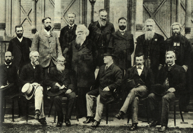 Ballarat Heritage Services
Image, Federation Convention, Melbourne, 1890, 1890
Black and white photographic image taken in Melbourne in 1890. During this meeting a draft constitution was becoming clearer. Back row: Andrew Inglis Clark, Captain William Russell (New Zealand), Sir Samuel Griffith, Sir Henry Parkes, Thomas Playford, Alfred Deakin, Bolton Stafford Bird, George Jenkins (Secretary to the Conference) Seated: William McMillan, Sir John Hall (New Zealand), John Macrossan, Duncan Gillies, Dr John Cockburn, Sir James Lee Steerefederation, federation convention, henry parkes, constitution, andrew inglis clark, captain william russell (new zealand), sir samuel griffith, sir henry parkes, thomas playford, alfred deakin, bolton stafford bird, george jenkins, william mcmillan, sir john hall, john macrossan, duncan gillies, dr john cockburn, sir james lee steere -
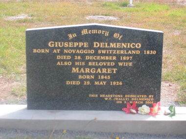 Ballarat Heritage Services
Photograph - Photograph - Colour, Guildford Cemetery
Headstones from the Guildford Cemetery. Headstones found in the cemetery include: ALFORD Phyllis Edith ANDERSON Phyllis Mary BARASSI Guiseppi, Jemima, Ann Conolly, Carlo Guiseppi, Carlo Guiseppi BAUD Catherine Edith BIRD Axel Jackson BISHOP George F, Elizabeth Futtrel BLACKMORE Lindsay Horace, Thelma Phyllis BLIGHT Edith Ann BLINKHORN Billinge, Amy Clark BOOTH Lyn BOURKE Gordon, Margaret BRANDON Janet Annie BYATT Elizabeth CANEVASCINI Vincenzo CARTER David, Ruth Vida CARTER Frank Noel CARTER Peggy Dawn CARTER Ruth, Strutten CASLEY George Alfred CERCHI Brian Maxwell CHAPMAN Stephen Henry James COX James, Sarah DARROCH Jennifer Anne DARROCH Robert Henry, Madge Annie DAVIES Marlene Kaye DAVIS Mark Richard DELL John, Anna DELMENICO Charles David, Robina May DELMENICO Giuseppe, Margaret DELMENICO Ivy May DELMENICO Jack, Adeline Marie DELMENICO Morris Charles DELMENICO Morris Vivian, Christina DELMENICO Pasqual Levio, Mary Ann DELMENICO Victor Guildford, Daisy Evelyn DELMENICO Victor M, Catherine DELMENICO Angelina (Quadri) DERRETT Edith Ellen DERRETT John William DOWNEY C L DOWNEY John Neville ELLIS Louisa, James, Emily, Edith Mary EMMETT Elsie Victoria, Robert Gordon ENVALL Paul Persson EVANS William George EVANS Florence Jane, William George EVANS John Herbert EWIN George Alton Cedric EWIN - MARTIN Marjorie Patricia FARRELL Lawrence John FLEMING James FOLETTI James Desmond FOLETTI John, Beatrice Emily FOLETTI Joseph, Susan Juliet FOLETTI Nell FOLETTI Virginia, John Alfred FOUND Joyce Lily FOUND Laurence Charles FRANZI Ann, Guiseppi Angelo FRANZI Clifford J, Ivy I FRANZI Marjorie, Harcourt F FRANZI Norman Charles FRANZI Sydney Gladstone, Augustus Lewis FRANZI Walter Edward, Amelia Selina FRANZI Giuseppi, Mary Ann Geeves, Edgar Alberto GALLICIOTTI G D GIBSON Frank D, Irene E GILL Charles Clifford GILL Gordon E, Alma M GILL Henry J E, Jane GLEN Douglas William GLEN Heather Lynette GLEN Winifred, Robert Alexander GLEN Robert Maxwell Stuart GLEN Ronald William GREENING Alfred James, Joyce HARDING Albert HARRIS Baby daughter of Raymond and Gail HARRIS Raymond John Wright HARRIS F D, Olwen Jennett HASSELL Marian HILL Daniel, Ada Maude HILL Isobel Mary, Daniel HILL Louisa Elizabeth, Emilie Jane, Robert, Sarah Jane HILL Frederick T HOLLAND Derek Patrick HOLLAND Anthony HOWLETT Walter , Zillah May HUNTER Bruce Andrew INGRAM Florence Ada KAY Gordon F, Beatrice KELLY Margaret KIDMAN Ann, John William KIDMAN George W, Mary Ann, Charlotte, Thomas KIDMAN Mary Jane, George J, George, Robert KIMPTON Violante O, Albert KINGSLEY Elizabeth KIRKPATRICK Colin McKay KIRKPATRICK Cyril E KIRKPATRICK Israel, Maria KIRKPATRICK Roy D KIRKPATRICK William H, Margaret LEE Annie Isobel (Vosti) LEONI Amy, Celestino LEONI Rosa LOMAS Robert A MANNING Roger Fielding MARSH Anthony Joseph MARTIN Sarah Jane, Wilfred MARTINOJA Filippo, Antonio, Domenica MARTINOJA Margaret McDONALD Ronald, Doris Annie McELHINNEY David G, Charles Galbraith McELHINNEY David Lewis, Mary Dorothy McELHINNEY Emily McGARRIGLE William L McKENDRY James Henry McQUEEN Charles, Olive May MEANEY Albert John, Emma Tomsey MEGEE Kay Leonore MEIN Alma Joan MEIN Ethel Muriel MEIN Eva, Norman D MEIN Florence MEIN Leonard Alvin, Hilda Margaret MEIN Wilfred Gordon MINHINNICK James Henry, Kathleen Dorothy Rose MOLLOY Matilda Seraphina, Richard, Matilda Winifred NICHOLLS G D, William NORTH Henry NORTH Henry, Margaret, Susannah OAKFORD W OLIVER PALLOTT Ernest Hiram PASSALAQUA Albert John, Louisa Emily PASSALAQUA Frederick, Prospero, Mary Ann PASSALAQUA John Antonio PASSALAQUA Laurie, Joyce PASSALAQUA Peter Francis PASSALAQUA Ronald Francis PASSALAQUA Virginia PASSALAQUA Zoe Victoria PASSALAQUA Frank PEDLER Horace Roy, Thelma PERRY Betty May (Simms), Alan Graham PIETSCH Allan William PIETSCH Florence Annie PINCINI Venanzia (formerly Bonetti, Leoni) POOLE Harry, Beryl Lyell POWELL Mary J, John PROWSE William Hubert PYWELL Albert James RALPH George RANKIN Percy, Harriet RASMUSSEN Eileen RAY Arthur Thomas REECE Ernest, Katie ROBERTS David, Lily ROBERTS Hannah Vernon ROBINS Davina B J RUSCONI Jane, John, Carlo, Carlo, William SCOTT Marietta SEWART Isaac, Margaret SHEEN Kenneth, Louisa SIMMONDS Lance Kurt, Rachael Pamela SIMMS Leslie T, Veronica Victoria SIMMS Margaret Jane, Harold Norman SIMMS Thomas, Louisa Emily SMARK Michael Joseph SMITH Annie Ethel SMITH Leslie Victor SOUTHWOOD William, Emily Thorpe STEVENS Clarence David, Ida STEVENS Daphne Jean, Arthur STEVENS Herbert Charles STEVENS Isobel, George STEVENS John, Fanny, Sarah STEVENS Leslie, Elaine STEVENS Mary K, Samuel STEVENS Mavis Ina, Roy Clifford STEVENS Roland Oswald STEVENS Samuel STEWART Charles, Catherine, Philip STEWART Francis, Ann STEWART Francis, Delfina STEWART Francis, Mary STEWART James A, Alice STEWART Leslie William STEWART Mary Madalene STEWART William STEWART William D, Gladys Irene STREETER Margaret Eugenie STREETER W G STURGESS Alan Robert STURGESS Albert John TAYLOR T R THOMAS Lily Ann THOMPSON Edwin James THOMSON - EWIN Kimley THORNHILL Peter Charles THRUSSELL R J - wooden cross TIRINANZI Pasqual TITHER Arthur, Mary Elizabeth TOGNI Angelina May, Massimo TOGNI Mary Caroline, Antonio Battista TRACEY Jacquiline Carol TRANTER Phyllis Elsie, Benjamin Alfred TREVENA George Robert TRUDGEON Eric, Vera May TULLO George TULLO John, Catherine TULLO John, Isabella TYZACK Dorothy Edith, Thomas William Paul TYZACK Harold Gordon, Louisa Caroline TYZACK Helen Adele UDEN Dorothy UNKNOWN Ron UNWIN Edward J, Edward G T VACA Milan, Margaret Mary VERLIN Elizabeth, James VOSTI Antonio Domenico, Victoria Kate VOSTI Brian Joseph VOSTI Giovanni Antonio VOSTI Joseph Charles, Ivy Elizabeth VOSTI William Francis VOSTI Antonio Domenico VOSTI Lucinda Margaret (Keating) WALKER David, William WATSON Mary Ascot (Vosti) WERNER George William WESTBROOK Dawn Frances, Eric Ernest WHARTON Richard, Jane WHARTON Thomas, Mary WHIDBOURNE Joyce Eileen WILLOUGHBY Trevor John WOOD Caroline V, E May WOOD Edwin David, Edna Letitia WOOD Edwin, Madeline WRIGHT Margaret, Annie Jane WRIGHT Reuben, Jessie, Elijah, Olive WYLIE William Abecrombie ZEPNICK Dennyvosti, delmenico, martonoja, sellars, guidlford, guildford cemetery -
 Ballarat Heritage Services
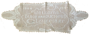
Photograph, Anne Gervasoni (Pedretti), Doily, c1944
Anne Pedretti was born at Elevated Plains on 15 September 1875, the daughter of Martino Pedretti and Sarah Ind. She married George Gervasoni of Yandoit Creek, and died at Dayesford on 13 August 1957. Annie Gervasoni was known for her crochet ability, and according to folklore could crochet the Lords Prayer without a pattern.Crocheted doily by Anne Gervasoni (Pedretti) of Daylesford. The words "1944 Welcome Duke and Duchess of Gloucester" has been crocheted into the design. crochet, doily, anne pedretti, anne gervasoni, duke of gloucester, duchess of gloucester, dry diggings, pedretti, elevated plains -
 Ballarat Heritage Services
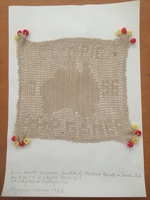
Domestic object - Doily, Anne Gervasoni (Pedretti), Olympic Games Doily, c1956
Anne Pedretti was born at Elevated Plains, Victoria, on 15 September 1875, the daughter of Martino Pedretti and Sarah Ind. She married George Gervasoni of Yandoit Creek, and died at Dayesford on 13 August 1957. Annie Gervasoni was known for her crochet ability, and according to folklore could crochet the Lords Prayer without a pattern.Crocheted milk jug cover by Anne Gervasoni (Pedretti) of Daylesford. The words "Olympic Games 1956" has been crocheted into the design. crochet, doily, anne pedretti, anne gervasoni, ekevated plains, dry diggings, pedretti, olympic games, melbourne olympic games -
 Ballarat Heritage Services
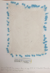
Domestic object - Sugar Bowl Cover, Anne Gervasoni (Pedretti), Sugar Bowl Cover by Anne Pedretti (later Gervasoni), c1950
Anne Pedretti was born at Elevated Plains on 15 September 1875, the daughter of Martino Pedretti and Sarah Ind. She married George Gervasoni of Yandoit, and died at Dayesford on 13 August 1957. Annie Gervasoni was known for her crochet ability, and according to folklore could crochet the Lords Prayer without a pattern.Crocheted sugar bowl cover by Anne Gervasoni (Pedretti) of Daylesford. The word "Sugar" has been crocheted into the design. crochet, doily, anne pedretti, anne gervasoni, dry diggings, pedretti, elevated plains, doiley, duke of gloucestor, duchess of gloucestor -
 Ballarat Heritage Services
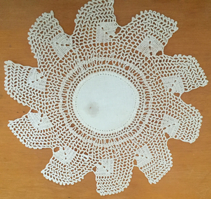
Textile - Doily, Anne Gervasoni (Pedretti), c1955
Anne Pedretti was born at Elevated Plains on 15 September 1875, the daughter of Martino Pedretti and Sarah Ind. She married George Gervasoni of Yandoit, and died at Dayesford on 13 August 1957. Annie Gervasoni was known for her crochet ability, and according to folklore could crochet the Lords Prayer without a pattern.Circular crocheted doily by Anne Gervasoni (Pedretti) of Daylesford. The doily was given to her future grand daugher-in-law, Kathleen Carroll who married John Hogan Gervasoni (Son of Gus Gervasoni and Elizabeth Hogan).crochet, doily, anne pedretti, anne gervasoni, dry diggings, pedretti, elevated plains, kathleen carroll, kathllen gervasoni, doiley, doilie