Showing 4602 items
matching historical maps
-
 Ringwood and District Historical Society
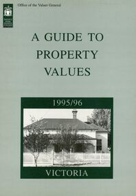
Book - Collection, Valuer General of Victoria, Guide to Property values in Victoria 1988-2006 (16 volumes), 1988-2004
part of the Richard Carter CollectionCollection of 16 books from the Office of the Valuer general with data and analysis of property values in Victoria by City and by Shire. With maps of local government. 1988-1994 A4 in size reducing to a slightly smaller size 1996-2006. Originals not kept - only scanned pages of City of Ringwood and Maroondah City Council PDFed. Refer to Victorian Government websites (www.land.vic.gov.au, www.consumer.vic.gov.au and others for Excel downloads and further details. -
 Ringwood and District Historical Society
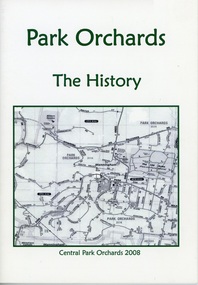
Booklet, Park Orchards -The History 2008
Cream covered booklet with green printing and map of area on the front. Also one on back. 23 pages with text and photographs. Re-created with permission from the Doncaster-Templestowe Historical Society Inc. by Park Orchards Learning centre Inc. -
 Ringwood and District Historical Society
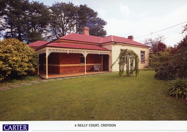
Memorabilia, History of Kleinert's Homestead, 4 Reilly Court, Croydon, Victoria
Collection of maps and title deeds of Kleinert's 1886 homestead - 22 pages in pockets in black plastic spiral binder, compiled by Richard Carter, November 2008. Photocopies of title deeds and subdivisions. -
 Ringwood and District Historical Society
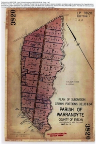
Document, Titles of land subdivision, Crown Portions 32, 33 & 34, Parish of Warrandyte, 1884 and 1907, Ringwood, Victoria
Evolution of the subdivision and the use of landBlack plastic bound pockets containing copies of 18 LANDATA subdivision maps and mortgage transfer pages dating from 1884 for 303 acres 2 roods and 1 perch bounded by Warrandyte Road, Wonga Road, Oban Road and Mullum Mullum Creek in Ringwood, Victoria. Certificates of Title include Vol 1606 Fol 045 Frederick Walter Purches 1884 and subsequent transfers to 1902, and Vol 3232 Fol 646357 Ann Jane Kennedy 1907 and transfers to 1921. -
 Ringwood and District Historical Society
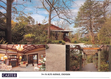
Document, Real Estate History of "Shadowood", 74-76 Alto Avenue, Croydon, Victoria
Folder of Estate Agent's notes compiled in preparation for property auction, 11th October, 2008. Two-page history of "Shadowood", display photo of house with floor plan dating from circa 1920s, copies of LANDATA title documents. Map of Wicklow Hills subdivision, including Alto Avenue, Elesmere Avenue, Glenora Avenue, Wicklow Avenue, and railway line to Lilydale. Title Vol 1323 Fol 264412 Allotment 43C Parish of Warrandyte - Ann McKean, dated 6th October, 1881. Title Vol 1937 Fol 387367 Part of Allotment 43C Parish of Warrandyte - Richard Bonynge Kelly, 11th August, 1887. Title Vol 2728 Fol 543569 Part of Allotment 43C Parish of Warrandyte - Thomas Robertson, 27th July, 1898. Title Vol 4161 Fol 832181 Part of Allotment 43C Parish of Warrandyte - John Gordon Robertson, 4th November, 1918. Title Vol 4490 Fol 897808 Lots 82 and 83, Plan of Subdivision 7478 - Elizabeth Rutherford Morell, 12th August, 1921. Title Vol 4617 Fol 923322 Lot 82, Plan of Subdivision 7478 - Flora Clapperton, 23rd September, 1922. Title Vol 8409 Fol 533, part of Lot 82, Plan of Subdivision 7478 - Hugh Ravenscroft Hastings Wettenhall and Sybella Anne Wettenhall, 1st May, 1962. -
 Ringwood and District Historical Society
Document - Extract from book "Bush Town to City" (Croydon, Victoria), Severance from the Shire of Lillydale 1952-1961
Addendum to folder of Estate Agent's notes compiled in preparation for property auction, "Shadowood", 74-76 Alto Avenue, Croydon, Victoria, 11th October, 2008. Ten pages plus map detailing the history of the severance of Croydon from Lillydale written by Robert Federick Jensen. -
 Ringwood and District Historical Society
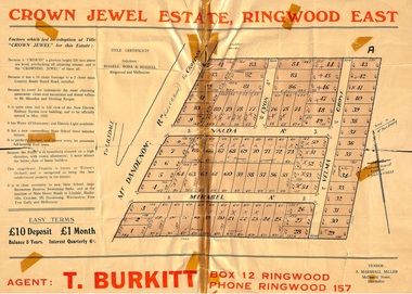
Memorabilia, History of "Jewel in the Crown" Estate, East Ringwood, Victoria, 1884-1947
Carter Real Estate Agents sold some of the subdivision in 1946-47. This information was tied in with the early orcharding families.Collection of notes, titles and maps of "Jewel in the Crown" subdivision - Mount Dandenong Road (formerly Oxford Road), Velma Grove, Valda Avenue, Mirabel Avenue. Genealogical charts of Meyland and Wigley families. 4 page history of the area compiled in 2004 by Richard Carter, Real Estate Agent. Registered Proprietors, Vendors, Property Title Holders and Transferees include: Herbert Edward WATSON, John Richard SHARP, Myrtle Evelyn BIRRELL, Marie Mathieson MUNRO, William Alex McCLELLAN, George Andrew GOODMAN, Joseph Tasman PEDRAZZI, Alexander ANDERSON, John Charles PATERSON, Eric William PHILLIPS, T.E.A. Co. Ltd., Florence Lavinia WYNARD, William John HARRIS, Lindsay and Hazel ALLNUTT, Douglas John RITCHIE, Eliza A.M. BOURBAND, Henrietta Irene COOK, Eric Edward COOK, Harold Thomas NICHOLLS, Stewart and Mary HIRD, Grace ROBINSON, Helen Rutherford GOOD, Henry Wyatt FARRELL, Irene Ann SMITH, Leslie Neil DOW, Helen Anne DOW, Frederick Ronald HOLDING, John Frederick McINTYRE, Horton Wilcox EDGE, Herbert James HARDINGHAM, Donald James ALLEN, Cyril Frederick WILLIAMS, Florence Sarah MAGGS, Maud Margaret PEARSON, Warwick Scott Holroyd MATTHEWS, Alice Eliza McCLEAVE, Leslie Archibald Charles HARRIS, Enid Beth HARRIS, Roy Victor DRAEGER, Elizabeth Ann STANDLEY, Charles Walter WATSON, Mabel Dorothy CARTER, Alan Garnett KELLY, Michael Vincent HARRIS, William Thomas Sylvester PROUD, Florence Blanche IVES, Douglas George PEARSON, Harry Clifford CLEGG, Dorothy Ellen Mary WHITE, Frederick Nathaniel EVANS, Madge EVANS, Leonard DUNSTAN, Violet Florence CONNELL, Valerie Jean Schimmelbusch, John Sydney COOK, William Donald THOMPSON, Ralph E RAUNSLEY, Murray McRae OSBORN, Francis William CLARKE, Alfred Daniel WILLIAMS, Harry Clifford CLEGG, Bernard Francis GARRY, Richard McKENZIE, Mignor Leonie WESTON, Idonea Moncrieffe DAVIS, Helen Marsden Rutherford GOOD, George SMART, Clement Henry DAVIS, Peter FINLAYSON, Elenor Leah HARVIE, Charles MEYLAND. -
 Ringwood and District Historical Society
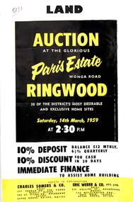
Flyer, Land Auction Advertisement, Paris Estate, Ringwood, Vic. - 1959
Double sided single page black and yellow printed advertisement for auction of home sites at Paris Estate, Wonga Road, Ringwood, Vic., on Saturday, 14th March, 1959, with terms of sale, locality map, subdivision features and summary of local services.Subdivision includes Mullum Mullum Road, Hendra Grove, Sunhill Road, and Wonga Road. Agents in conjunction: Charles Somers & Co., South Yarra and Melbourne, and Eric Weber & Co., Melbourne and East Melbourne. -
 Ringwood and District Historical Society
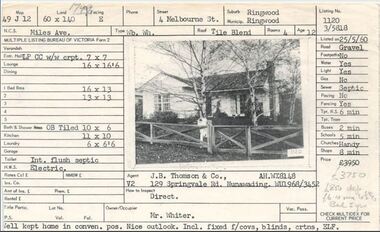
Document, Property profile for sale of house and land, 4 Melbourne Street, Ringwood, Victoria - 1960
The house was owned by Mrs. Jessie White 4, Melbourne St. on the corner of Miles Ave. now both lost in the development of Eastland Shopping Centre.Details include map reference, dimensions of land and living space, picture of house, details of local services. Owner/Occupier Mr. Whiter. Agent J.B. Thomson & Co., 129 Springvale Road, Nunawading. -
 Ringwood and District Historical Society
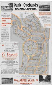
Map, Park Orchards Land Sale Advertisement, Doncaster, Victoria, Circa 1926
Large linen backed map of the Park Orchards subdivision for private sale of residential sites and recreation club, highlighting local facilities, services and layout of the estate. Surveyors - Tuxen & Miller, 34 Queen Street, Melbourne. Agents - Wm Addey & Co., Pty Ltd., National Mutual Buildings, 395 Collins Street, Melbourne, Phone F3906. Terms £5 deposit balance monthly installments of £1 with the residue at the end of five years. Subdivision includes Alva Avenue, Arundel Road, Aviemore Avenue, Berringa Road, Bowmore Avenue, Brucedale Crescent, Brympton Avenue, Camber Avenue, Cawdor Avenue, Colin Avenue, Corriedale Crescent, Craithie Avenue, Daintree Avenue, Dalry Avenue, Dirlton Crescent, Drayton Crescent, Elgin Crescent, Enfield Avenue, Ennismore Crescent, Euston Avenue, Feversham Avenue, Frogmore Crescent, Gosford Crescent, Granard Avenue, Hopetoun Road, Hylton Avenue (later Knees Road), Jura Avenue, Park Road. -
 Ringwood and District Historical Society
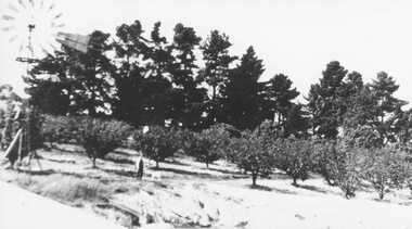
Photograph, H.E. Watson's orchard- Ringwood East. c1900's
Black and white photographWritten on backing sheet- "H. E. Watson's Orchard. Ringwood East." Included with image is a copy of early street map showing location of orchard on corner of Old Lillydale Road and Maroondah Highway.agriculture -
 Ringwood and District Historical Society
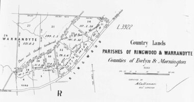
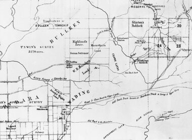
Photograph, Early map of parishes of Ringwood and Warrandyte in Counties of Evelyn and Mornington - c.1868, 1868
Copy of an early map of parishes of Ringwood and Warrandyte, Counties if Evelyn and MorningtonWritten on backing sheet, "c1868. Vol. 5, Fol.13/1224". -
 Ringwood and District Historical Society
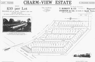
Photograph, Land sale advertisement for Charm View Estate, Heathmont - 1927
Map - Charm-View EstateTyped below photograph, "From 1927 land subdivision brochure". -
 Ringwood and District Historical Society
Photograph, Circa 1855 Parish Map including Bulleen, Nunawading, and eventual site of Ringwood below blocks 23 & 24
Catalogue card reads, "C1858 Parish Map - Nunawading, Ringwood & Scoresby". -
 Ringwood and District Historical Society
Photograph, Parish Map - Township of Ringwood - 1890
Written on backing sheet, 'SLV Parish Map Collection. Vol.67, Fol. 43, 1890'. Catalogue card reads, 'SLV Parish Map Collection 1890. (Township of Ringwood). -
 Ringwood and District Historical Society
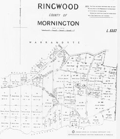
Photograph, Parish map of Ringwood, County of Mornington - 1878
Copyright note states "Crown (State of Victoria) Copyright 1973"Written on backing sheet, "SLV Parish Map Collection Vol.23, Fol.64". -
 Ringwood and District Historical Society
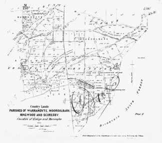
Photograph, Map-Parishes of Warrandyte, Mooroolbark, Ringwood and Scoresby. 1870
Photograph of map "Country Lands - Parishes of Warrandyte, Mooroolbark, Ringwood and Scoresby - Counties of Evelyn and Mornington" dated 1870. -
 Ringwood and District Historical Society
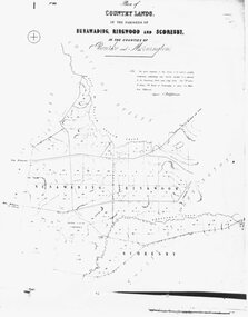
Photograph, Map-Country Lands, in the parishes of Nunawading, Ringwood and Scoresby (undated)
Early (undated) photograph of plan of "Country Lands, in the parishes of Nunawading, Ringwood and Scoresby, in the counties of Bourke and Mornington". -
 Ringwood and District Historical Society
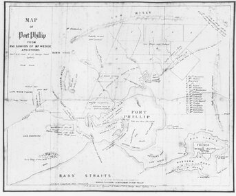
Photograph, Map of Melbourne & Vicinity - 1853. Survey of Port Phillip. Plan in Bonwick's "Settlement of Port Phillip"
Catalogue card reads, 'Map of Melbourne & Vicinity - 1853. Survey of Port Phillip. Plan in Bonwick's "Settlement of Port Phillip"'. -
 Ringwood and District Historical Society
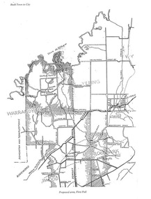
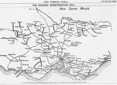
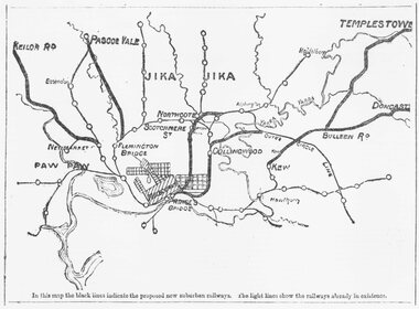
Photograph, Map showing Victoria's proposed railway system, 1890
Catalogue card reads, 'Map showing Victoria's proposed railway system, 1890. -
 Ringwood and District Historical Society
Photograph, Map of Melbourne suburbs showing proposed new railway lines - 1890
Catalogue card reads, 'Map of Melbourne suburbs showing proposed new lines - 1890.' -
 Ringwood and District Historical Society
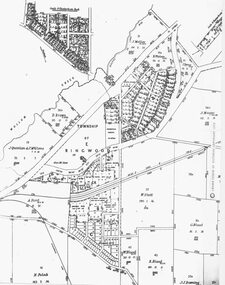
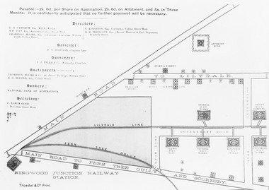
Photograph, Land sale brochure map of Ringwood's early main central area around Mount Dandenong Road - c.1880s
Catalogue card reads, 'Map of Ringwood East'. -
 Ringwood and District Historical Society
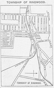
Photograph, Directory of Ringwood Township, from Sands and McDougall Directory - 1905. (New Street is incorrectly shown as Heatherdale Road on this map. Heatherdale Road's actual location is to the east, beyond the top of the map perimeter.)
Catalogue card reads, 'Directory of Ringwood Township - 1905. From Sands and McDougall Directory.' -
 Orbost & District Historical Society
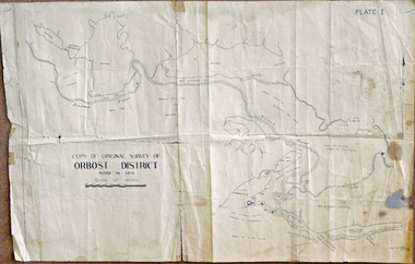
survey, 26th July 1950
This map is a research tool for identifying historical land records in Orbost.A copy of the original survey of Orbost District 1870. White background with black print. The original was hand-drawn in ink. This is PLATE 1.some pen marksmap survey-orbost -
 Orbost & District Historical Society
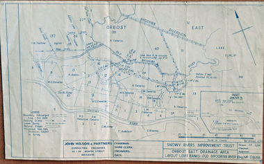
plan, December 1968
Brodribb floodplain regularly inundated in the late 1800s and early 1900s. Works included: clearing the river channel and blocking ‘gulches’. The meander was cut-off in 1931, as part of the Orbost East Drainage Scheme and further developed after 1934 floods and again in the early 1950s when levee banks and a regulator were constructed. (ref. East Gippsland Catchment Management)This is a useful reference tool.A hand-drawn plan of the layout of the levee banks of the Old Brodribb River.brodribb-river map plan-levee-banks -
 Orbost & District Historical Society
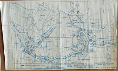
survey, 1941
this item is a useful reference tool.A survey map produced by the State Rivers and Water Supply Commission. It is on white paper with blue ink. It is a hand-drawn survey of the Snowy River in 1939-40.survey map snowy-river -
 Orbost & District Historical Society
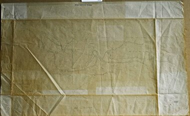
survey sheet, circa 1870's
E.L. Bruce, born in Ireland on July 1,1854, came to Australia in 1854 and joined the Lands Department. He spent most of his service in Gippsland. The journey to Sale then was made by ship to Port Albert and thence on horseback. He began his service in Gippsland as assistant district surveyor and for the last 12 years before retirement he was district surveyor and land officer. His territory extended from the boundary of Victoria in east Gippsland down to Wilson's Promontory with his headquarters at sale.This map is a useful reference tool.A survey map - Sheet No 3 SnowyRiver Survey. This is a copy of the original survey. It shows the properties of W.J.T. Clarke - two in Orbost and one in Newmeralla (sic),. it has a faded, undecipherable red stamp in the bottom right corner.Gipps Land Rivers No 32B E.L. Brucesurvey bruce-e.l snowy-river-c19th -
 Orbost & District Historical Society
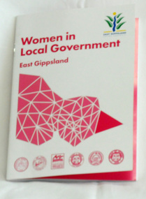
book, Women in Local government, 2015
This book was produced by East Gippsland Shire Council's Communication Unit - Janek Krause, Emma Langres and David Radford. It was supported by East Gippsland Historical society an Tim Gibson. This book celebrates the work of women in local government in East Gippsland. It is an excellent reference tool.A 42 pp stapled book titled, Women in Local Government. It is a collection of stories of women who have served as councillors in East Gippsland. The cover is white with magenta print,. In the top right corner is the East Gippsland Shire Council logo. In the centre is a stylised map of Victoria divided into shires with the East Gippsland shire highlighted.local-government east-gippsland women-in-government -
 Orbost & District Historical Society
book, Vic Roads Centenary 1913 -2013, 2013
The publication, VicRoads Centenary: Keeping Victorians Connected for 100 Years, looks at the people and projects that define VicRoads’ history. Written by current and former VicRoads’ employees, the publication details the organisation’s portfolio of major projects, which includes the Great Ocean Road, Hume Highway and Eastern Freeway. Other sections report on Victoria’s world-first road safety initiatives, VicRoads’ use of technology and sustainability measures. (ref VicRoads) This item is one of several books donated by David Jellie at a presentation to Orbost Historical Society. He was a contributor to the book and was the engineer for the Snowy River Bridge (Princes Highway) at Orbost 1974-1976.This book is a useful reference tool on the history of road construction in Victoria including East Gippsland.A thick, bound paperback book, titled "VicRoads Centenary Keeping Victorians Connected for 100 Years". On the front cover is a black/white photograph of two men working on a road. One has a pick. The book contains the history of VicRoads, photographs, maps and advertisements. Some are b/w. Others are coloured.vicroads book roads snowy-river-bridge jellie-david -
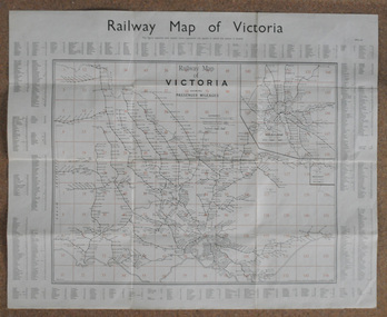 Orbost & District Historical Society
map, Railway Map of Victoria, 1.8.1965
The Bairnsdale-Orbost railway was opened in 1916 to serve the agricultural and timber industry. Because of the decline in traffic and heavy operating costs, the line was finally closed in August, 1987.This item is associated with the history of the Orbost-Bairnsdale railway line and therefore reflects the role that the rail line played in the social and economic history of Orbost.A large rectangular shaped paper map of all railway stations in Victoria. It is dated 1st August 1965. It is divided into grids. Stations are listed around the map. A key is provided and each station has a grid reference.map-railway victorian-railways