Showing 10906 items
matching lake.
-
 Ringwood and District Historical Society
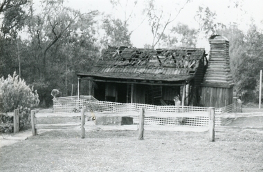
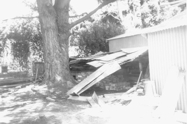
Photograph, Miner’s Hut, Ringwood Lake, after fire 20th September 1991
Digital photograph -
 Eltham District Historical Society Inc
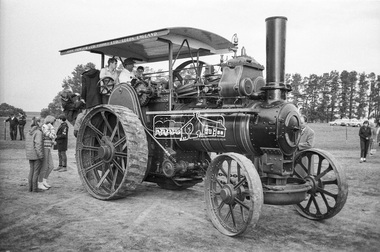
Photograph, George Coop, Lake Goldsmith Steam Rally, Beaufort, Vic, c.1971
Digital TIFF file Scan of 35mm Ilford HP4 black and white negative transparency, c.1971george coop collection, lake goldsmith steam rally, steam rally, beaufort (vic.), steam traction engine -
 Eltham District Historical Society Inc
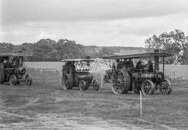
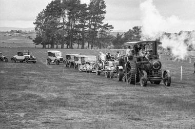
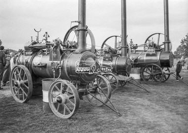
Photograph, George Coop, John Fowler & Co. Steam Traction Engine heads a parade of vehicles at Lake Goldsmith Steam Rally, Beaufort, Vic, c.1971
Digital TIFF file Scan of 35mm Ilford HP4 black and white negative transparency, c.1971george coop collection, lake goldsmith steam rally, steam rally, beaufort (vic.), steam traction engine, chrysler 75 roadster, ford model t, john fowler & co. (leeds) ltd -
 Eltham District Historical Society Inc
Photograph, George Coop, Lake Goldsmith Steam Rally, Beaufort, Vic, c.1971
Digital TIFF file Scan of 35mm Ilford HP4 black and white negative transparency, c.1971george coop collection, lake goldsmith steam rally, steam rally, beaufort (vic.), steam traction engine -
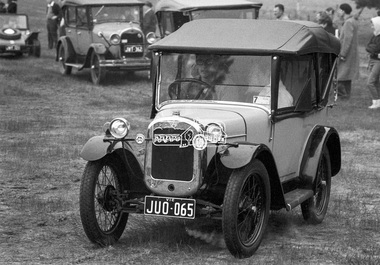 Eltham District Historical Society Inc
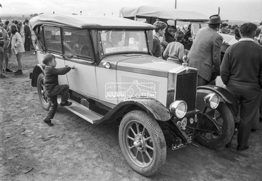
Photograph, George Coop, Austin 7, Lake Goldsmith Steam Rally, Beaufort, Vic, c.1971
Digital TIFF file Scan of 35mm Ilford HP4 black and white negative transparency, c.1971george coop collection, lake goldsmith steam rally, steam rally, beaufort (vic.), steam traction engine, austin 7, automobile, beach buggy, car, chevrolet series 490 -
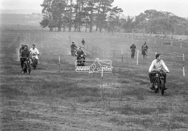 Eltham District Historical Society Inc
Photograph, George Coop, Lake Goldsmith Steam Rally, Beaufort, Vic, c.1971
Digital TIFF file Scan of 35mm Ilford HP4 black and white negative transparency, c.1971george coop collection, lake goldsmith steam rally, steam rally, beaufort (vic.), motorcycles -
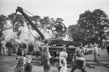 Eltham District Historical Society Inc
Photograph, George Coop, Lake Goldsmith Steam Rally, Beaufort, Vic, c.1971
Digital TIFF file Scan of 35mm Ilford HP4 black and white negative transparency, c.1971george coop collection, lake goldsmith steam rally, steam rally, beaufort (vic.) -
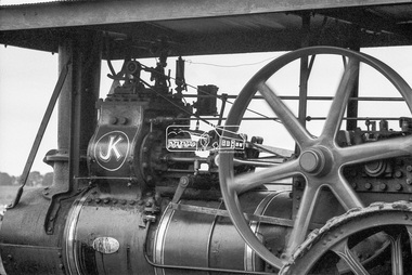
 Eltham District Historical Society Inc
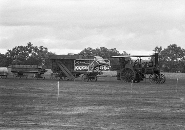
Photograph, George Coop, John Fowler & Co. Steam Traction Engine for ploughing, Lake Goldsmith Steam Rally, Beaufort, Vic, c.1971
Manufactured by John Fowler & Co. (Leeds) Ltd, Leeds, England Digital TIFF file Scan of 35mm Ilford HP4 black and white negative transparency, c.1971george coop collection, lake goldsmith steam rally, steam rally, beaufort (vic.), john fowler & co. (leeds) ltd, steam traction engine -
 Eltham District Historical Society Inc
Photograph, George Coop, Lake Goldsmith Steam Rally, Beaufort, Vic, c.1971
Digital TIFF file Scan of 35mm Ilford HP4 black and white negative transparency, c.1971george coop collection, lake goldsmith steam rally, steam rally, beaufort (vic.), steam traction engine -
 Eltham District Historical Society Inc
Photograph, George Coop, FN 14000 at Lake Goldsmith Steam Rally, Beaufort, Vic, c.1971
Digital TIFF file Scan of 35mm Ilford HP4 black and white negative transparency, c.1971george coop collection, lake goldsmith steam rally, steam rally, beaufort (vic.), fn 1400, automobile, car -
 Eltham District Historical Society Inc
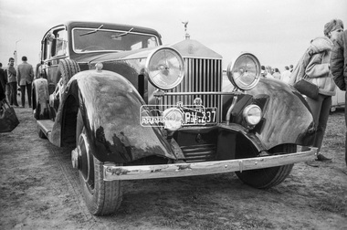
Photograph, George Coop, Rolls Royce Phantom II, Lake Goldsmith Steam Rally, Beaufort, Vic, c.1971
Note the unusual windscreen wiper location above the screen Digital TIFF file Scan of 35mm Ilford HP4 black and white negative transparency, c.1971george coop collection, lake goldsmith steam rally, steam rally, beaufort (vic.), automobile, car, rolls royce phantom ii -
 Federation University Historical Collection
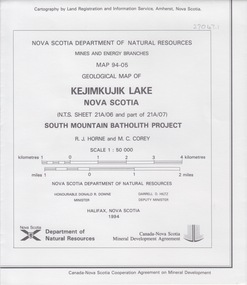
Map - Geological, Nova Scotia Department of Natural Resources, Kejimkujik Lake, Nova Scotia: Geological Map 94-05, 1994
Produced b Nova Scotia Department of Natural Resources, Mines and Energy Branches. The Minister of the Department was the Honourable Donald R Downe and the Deputy Minister was Darrell D HiltzLarge coloured map depicting different areas and deposits. Includes a legend, symbols used, mineral abbreviations and alteration abbreviations.Symbolsnova scotia, kejimkujik lake, geological survey, cartography, mine and energy branches, donald r downe, minister, darrell d hiltz, deputy mnister, south mountain batholith project, legend, symbols -
 Federation University Historical Collection
Map - Map - Geological, Kejimkujik Lake, Nova Scotia: Geological Map 94-05, 1994
Produced by Nova Scotia Department of Natural Resources, Mines and Energy Branches. The Minister of the Department was the Honourable Donald R Downe and the Deputy Minister was Darrell D HiltzLarge coloured map depicting different areas and deposits. Includes a legend, symbols used, mineral abbreviations and alteration abbreviations.Symbolskejimkujik lake, nova scotia -
 Federation University Historical Collection
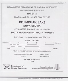
Map - Geological, Kejimkujik Lake, Nova Scotia: Glacial and Till Clast Geology: Map 94-12, 1994
Produced b Nova Scotia Department of Natural Resources, Mines and Energy Branches. The Minister of the Department was the Honourable Donald R Downe and the Deputy Minister was Darrell D HiltzLarge coloured map depicting different areas and deposits. Includes a legend, symbols used, mineral abbreviations and alteration abbreviations.Symbols -
 Federation University Historical Collection
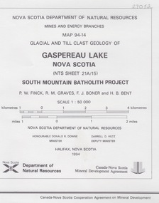
Map - Geological, Gaspereau Lake, Nova Scotia: Glacial and Till Clast Geology: Map 94-14, 1994
Produced by Nova Scotia Department of Natural Resources, Mines and Energy Branches. The Minister of the Department was the Honourable Donald R Downe and the Deputy Minister was Darrell D HiltzLarge coloured map depicting different areas and deposits. Includes a legend, symbols used, mineral abbreviations and alteration abbreviations.Symbolsnova scotia, department of natural resources, mines and energy branch, donald r downe, minister, darrel d hiltz, deputy minister, glacial and till clast, geo;logy, south mountain batholith project -
 Federation University Historical Collection
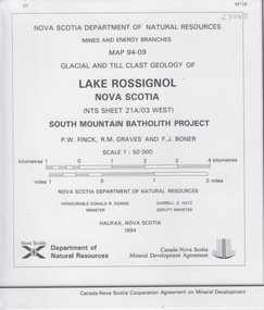
Map - Geological, Lake Rossignol, Nova Scotia: Glacial and Till Clast Map 94-09: Souh Mountain Batholith Project
-
Federation University Historical Collection
Photograph, Ballarat School of Mines Excursion to Lake Burumbeet, 1899
lake burumbeet, excursion, ballarat school of mines, oliver jaeger, oliver jager -
Phillip Island and District Historical Society Inc.
Book, SCOTT, Walter, Lady of the lake, 1911
-
Phillip Island and District Historical Society Inc.
Book, De COLANGE, Leo, picturesque world, or, Scenes in many lands, with one thousand illustrations on wood and steel of picturesque views from all parts of the world comprising mountain, lake and river scenery, parks, palaces, cathedrals, churches, castles, abbeys, and other views selected from the most noted and interesting parts of the world ; with original and authentic descriptions by the best authors, 1878-9
Labelled 'Cowes Free Public Library', 'Phillip Island Historical Society, Cleeland Bequest'. V.2 inscribed 'Jno. Cleeland, Wollomai' -
 Eltham District Historical Society Inc
Photograph, Hume and Hovell Monument, near Lake Nillachootie, Barjarg, Spring Excursion, Hume and Hovell's 1824 expedition (Part 2), 26 October 1997, 26/10/1997
[article by Diana Bassett-Smith in EDHS Newsletter No. 117, November 1997:] MONUMENT HUNTING THE HUME AND HOVELL WAY - Sunday October 26 1997 dawned bright and very warm. Some twenty-five members, complete with picnic baskets, met outside the Eltham Library awaiting the Cobb and Co. large coach which would be taking us on the second leg of our travels along the route of the early explorers Hume and Hovell. Stephen West was our very good driver for the day. He would be guided around the circuitous route by Russell Yeoman who had made a detailed study, not only of the intended route, but of the story of these two explorers. During the trip Russell regaled us with poetry, quotations from the Journals and the History of the Shire of Seymour, "The New Crossing Place" by Martindale, 1982, (now Mitchell Shire due to the recent amalgamations). We headed towards the Hume Highway via Greensborough and Cooper Street and proceeded north to our first stop, noting on the way Monument Hill in the distance which is near Kilmore and, according to Russell, well worth the effort to visit as the view across the valley is magnificent. Past Sunday Creek Valley, Mt Piper and Mt Disappointment, all traversed and noted and named by them. We passed through Tallarook, then onto Seymour where we took photos of the monument telling us that Hume and Hovell had passed through on the 28th of October 1824. We also deviated down Hume and Hovell Road viewing deer and emu farming and the Bellbourie property now a sanctuary. Leaving Seymour behind we travelled up the Avenel Road to the Avenel monument, pyramidal in design of four reducing square blocks with a sharply pointed peak, erected in 1924 in memory of the 1824 exploration. The day was warming up and the countryside showing the dryness of the current drought. A parallel note had been made in their journal too of 1824 of the drought appearance of the country they were traversing. At Seven Creeks, Euroa we stopped for some minutes to check the monument placed 20th November 1924 to commemorate their passage on the 29th December 1824. More photos. Russell had pointed out the abrupt termination of the distant ranges which is noted in their journal. The next monument is beside the road at the entrance to Honey Suckle Creek Caravan Park, Violet Town. The squarish shaped monument some eight feet high is topped with a simple steel cross, and was to mark the date of 28th December 1824 and built for the 20th November 1924. By now it was 12.20 and nearly lunchtime as we drove along the Warranbayne Road to Roach's Road, monument hunting without success. Though there is a large, what appears to be an old timber sign which was hard to read, maybe this was the lost monument. In many of the paddocks hay had been cut and baled or was being cut, what a contrast to the rugged country they had passed through which was smoky from the fires of the natives burning off. By 1.00 pm we were at Benalla and pulled up beside the park where abundant beds of roses filled the air with their scent and the smell of barbecued food twitched the nostrils whilst the cheerful sounds of other picnickers could be heard throughout the park. We left the bus and collected up our picnics, dispersed to the various tables and enjoyed the shade from the various European trees. 2.00 pm and we were on the road again driving along the Benalla, Mansfield, Yea road. The Swanpool monument states that they passed four miles south and returned three miles north. Then we stopped at the Barjarg monument which notes that they camped near this spot. It is again a pyramidal monument and this time topped with a steel arrow indicating their route of the 29th November 1824. Half an hour later we came to another monument, again with a steel arrow marker on top and the plaque dated the 2nd of 12th 1824. Erected on the 12th of 12th 1924. "They blazed the way that we might inherit the land." Another square based and needle topped monument appeared at Yarck near Yea and this plaque records the date of 3 December 1824. Near McGuigans Road Russell related that the expedition had lost a dog but it had found them next day, the dog was apparently torn by a kangaroo. A short while later Russell reminded us here of the problems they encountered in crossing the Goulburn River near Molesworth where banks were high, water deep and wide. "Good coat of grass but quite dry due to drought". At Yea we stopped for afternoon tea and raided the last of our picnics and looked at the monument to their journey of 1824, situated at a corner of the gardens near the bowling green. No photo – we were out of film. We returned home via Kinglake West and Whittlesea past the Yan Yean Reservoir, not full. 5.00 pm back at Eltham we emptied out of the bus and everyone, including Joan Cole, collected their things, Joan also had the major souvenir of the day, a large carp she had picked up from the river bank, her cat was in for a great feast. The day was made so interesting by the informed commentary which Russell provided. His background knowledge of the route and nature of the journey could only have come from many hours of reading and driving the area. Thank you to Russell and to everyone who made the day so informative and pleasurable. Colour photographactivities, hume and hovell, monument, barjarg, lake nillachootie -
 Ringwood and District Historical Society
Document, Paul Kempton, The Effects of the Environment on the Ringwood Lake by Paul Kempton - 1983 (2 pages), 1983
-
 Ringwood and District Historical Society
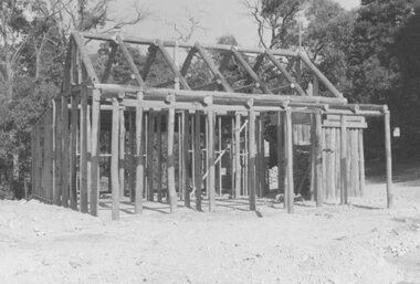
Photograph, Replica Miner's Cottage at Ringwood Lake Park, Maroondah Highway, Ringwood, photographed progressively during construction and leading up to the official opening by Cr. Pat Gotlib, Mayor of Ringwood, and Mrs. Ellie Pullin, Ringwood Historical Research Group on 29th May, 1983
Catalogue card reads, "Miner's cottage 1983. Official opening on 29th May 1983 by Cr. Pat Gotlib, Mayor of Ringwood (6 copies). Miner's cottage (11 copies), interior pictures of miner's cottage (13 copies), chimney and fireplace (1 copy)". -
 Ringwood and District Historical Society
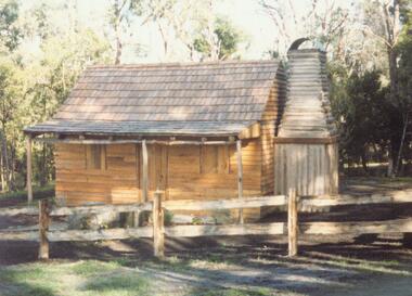
Photograph, Replica Miner's Cottage at Ringwood Lake Park, Maroondah Highway, Ringwood - Officially opened on 29th May, 1983
Catalogue card reads, "Miner's cottage 1983. Official opening on 29th May 1983 by Cr. Pat Gotlib, Mayor of Ringwood (6 copies). Miner's cottage (11 copies), interior pictures of miner's cottage (13 copies), chimney and fireplace (1 copy)". -
 Ringwood and District Historical Society
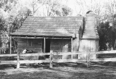
Photograph, Miner's cottage replica, Ringwood Lake - circa late 1990s
No catalogue card, but photograph of miner's cottage. -
Ringwood and District Historical Society
Envelope, Packet: Ringwood Park and Reserves, Dawe's Lake; 1853 Gardiner's Chronicle; 1938 Parliamentary inspections; 1926 report. Etc
1. Borough of Ringwood Parliamentary inspection recreation grounds 12-May-1938; 2. Baths & playgrounds for the Eastern Districts 12-May-1938; 3. Bundle of typed and hand written letters & notes; 4. Playgrounds for children 19-Aug-1926 -
 Ringwood and District Historical Society
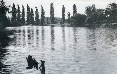
Photograph - Digital image, Ringwood Lake 1987, 1987
Taken from AW Dickson 1987 calendar. Refer to VC item 26282 for full details -
 Ringwood and District Historical Society
Photograph, Sections of the miner's cottage removed from it's original location on Maroondah Highway to the council depot in January 1979, but never used in eventual reconstruction at Ringwood Lake in 1983
Catalogue card reads, "January 1979. Miner's cottage in pieces at second resting place, in council depot near front gate - on left under big pine tree". -
 Ringwood and District Historical Society
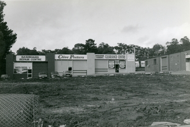
Photographs, Demolished Caltex Service Station in Maroondah Hwy (near lake) in 1997
-
 Ringwood and District Historical Society
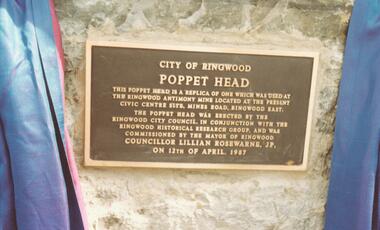
Photograph, Commemorative stone unveiled by the Mayor of Ringwood, Cr. Lillian Rosewarne, JP. on 12 April, 1987, marking the completion of the antimony mine Poppet Head reconstruction project at Ringwood Lake
Catalogue card reads, 'Council ceremonies. Unveiling stone at Poppet Head, 1985 and then opening of Poppet Head 1987'.