Showing 116780 items
matching orbost-brodribb-road
-
 Eltham District Historical Society Inc
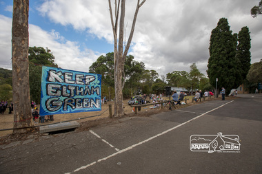
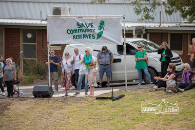
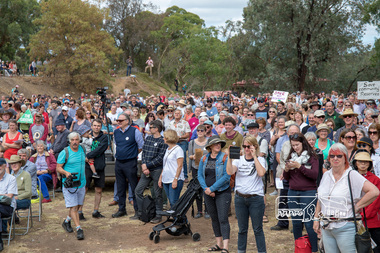
Photograph, Members of the community gather on the site of the former Shire of Eltham offices, Save Community Reserves Rally, Main Road, Eltham, 4 March 2018, 4/3/2018
Protest rally against Nillumbik Shire Councillors' proposal to sell off 17 community reserves. Held at the site of the former Shire of Eltham offices, at 895 Main Road, which were demolished in August 1996, followed by a march along Main Road finishing at the Eltham Railway Station car park at Luck Street. Estimated attendance was approximately 3,000.Born digital image (8)nillumbik shire council, parks, save community reserves, protest rally -
 Eltham District Historical Society Inc
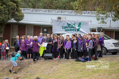
Photograph, The Chocolate Lilies Choir kick off the entertainment, Save Community Reserves Rally, Main Road, Eltham, 4 March 2018, 4/3/2018
Protest rally against Nillumbik Shire Councillors' proposal to sell off 17 community reserves. Held at the site of the former Shire of Eltham offices, at 895 Main Road, which were demolished in August 1996, followed by a march along Main Road finishing at the Eltham Railway Station car park at Luck Street. Estimated attendance was approximately 3,000.Born digital image (15)nillumbik shire council, parks, save community reserves, protest rally -
 Eltham District Historical Society Inc
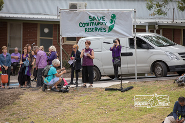
Photograph, Nerida Kirov, one of the rally organisers, addresses the crowd, Save Community Reserves Rally, Main Road, Eltham, 4 March 2018, 4/3/2018
Protest rally against Nillumbik Shire Councillors' proposal to sell off 17 community reserves. Held at the site of the former Shire of Eltham offices, at 895 Main Road, which were demolished in August 1996, followed by a march along Main Road finishing at the Eltham Railway Station car park at Luck Street. Estimated attendance was approximately 3,000.Born digital image (16)nillumbik shire council, parks, save community reserves, protest rally -
 Eltham District Historical Society Inc
Photograph, Sarah Krug, one of the rally organisers from Save Community Reserves, addresses the crowd, Save Community Reserves Rally, Main Road, Eltham, 4 March 2018, 4/3/2018
Protest rally against Nillumbik Shire Councillors' proposal to sell off 17 community reserves. Held at the site of the former Shire of Eltham offices, at 895 Main Road, which were demolished in August 1996, followed by a march along Main Road finishing at the Eltham Railway Station car park at Luck Street. Estimated attendance was approximately 3,000.Born digital image (10)nillumbik shire council, parks, save community reserves, protest rally -
 Eltham District Historical Society Inc
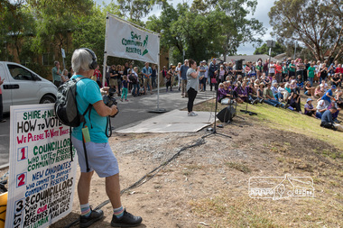
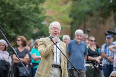
Photograph, Historian, Andrew Lemon addresses the crowd, Save Community Reserves Rally, Main Road, Eltham, 4 March 2018, 4/3/2018
Protest rally against Nillumbik Shire Councillors' proposal to sell off 17 community reserves. Held at the site of the former Shire of Eltham offices, at 895 Main Road, which were demolished in August 1996, followed by a march along Main Road finishing at the Eltham Railway Station car park at Luck Street. Estimated attendance was approximately 3,000.Born digital image (13)nillumbik shire council, parks, save community reserves, protest rally -
 Eltham District Historical Society Inc
Photograph, Former Mayor, Margaret Jennings addresses the crowd, Save Community Reserves Rally, Main Road, Eltham, 4 March 2018, 4/3/2018
Protest rally against Nillumbik Shire Councillors' proposal to sell off 17 community reserves. Held at the site of the former Shire of Eltham offices, at 895 Main Road, which were demolished in August 1996, followed by a march along Main Road finishing at the Eltham Railway Station car park at Luck Street. Estimated attendance was approximately 3,000.Born digital image (8)nillumbik shire council, parks, save community reserves, protest rally -
 Eltham District Historical Society Inc
Photograph, Greg Champion entertains the crowd, Save Community Reserves Rally, Main Road, Eltham, 4 March 2018, 4/3/2018
Protest rally against Nillumbik Shire Councillors' proposal to sell off 17 community reserves. Held at the site of the former Shire of Eltham offices, at 895 Main Road, which were demolished in August 1996, followed by a march along Main Road finishing at the Eltham Railway Station car park at Luck Street. Estimated attendance was approximately 3,000.Born digital image (19)nillumbik shire council, parks, save community reserves, protest rally -
 Eltham District Historical Society Inc
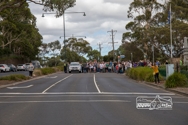
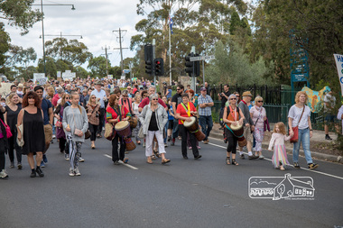
Photograph, The head of the march by some 3,000 people, Save Community Reserves Rally, Main Road, Eltham, 4 March 2018, 4/3/2018
Protest rally against Nillumbik Shire Councillors' proposal to sell off 17 community reserves. Held at the site of the former Shire of Eltham offices, at 895 Main Road, which were demolished in August 1996, followed by a march along Main Road finishing at the Eltham Railway Station car park at Luck Street. Estimated attendance was approximately 3,000.Born digital image (9)nillumbik shire council, parks, save community reserves, protest rally -
 Eltham District Historical Society Inc
Photograph, Percussion accompaniment at the head of the march, Save Community Reserves Rally, Main Road, Eltham, 4 March 2018, 4/3/2018
Protest rally against Nillumbik Shire Councillors' proposal to sell off 17 community reserves. Held at the site of the former Shire of Eltham offices, at 895 Main Road, which were demolished in August 1996, followed by a march along Main Road finishing at the Eltham Railway Station car park at Luck Street. Estimated attendance was approximately 3,000.Born digital image (3)nillumbik shire council, parks, save community reserves, protest rally -
 Eltham District Historical Society Inc
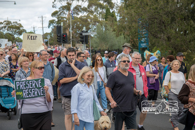
Photograph, Save Community Reserves Rally, Main Road, Eltham, 4 March 2018, 4/3/2018
Protest rally against Nillumbik Shire Councillors' proposal to sell off 17 community reserves. Held at the site of the former Shire of Eltham offices, at 895 Main Road, which were demolished in August 1996, followed by a march along Main Road finishing at the Eltham Railway Station car park at Luck Street. Estimated attendance was approximately 3,000.Born digital image (58)nillumbik shire council, parks, save community reserves, protest rally -
 Whitehorse Historical Society Inc.
Document, Constituting a road district to b a shire, 1857, 1862, 1872
Extract from Government Gazette(iv)Extract from Government Gazette No 25, 3 May 1872 - Proclamation of Shire of Nunawading. (v) Extract from Victorian Government Gazette, 7 Aug 1857 - Proclamation of Nunawading Road District (vi) Public meeting for election of members for Nunawading District Roads Board.Extract from Government Gazette local government, nunawading road district, shire of nunawading, barkly, henry sir -
 Surrey Hills Historical Society Collection
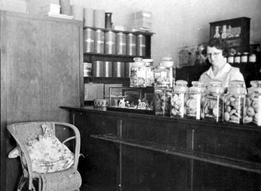
Photograph, Anne's Pantry, 165 Union Road, Surrey Hills in 1947
In 1930 Miss Anne Cook opened Anne’s Pantry, a home-made cakeshop at 165 Union Road, but later moved to 135 Union Road. The business of the same name is currently (2018) located at 139 Union Road. Miss Cook used to catch the first train up from Auburn and usually worked into the evening. Eventually the long hours took their toll and she had to sell. Miss E Porteous, her assistant, pictured in this photo, remained for many years with later owners. She recalled: “On the first day we opened at 10 a.m., the people surged in and within half an hour there wasn’t a cake left.” A black and white photograph of a shop interior. There are a number of large jars full of biscuits sitting on the counter. Large tins and boxes are on the shelf to the left hand side. A wicker chair is beside the counter, and part of a table and chair is on the far left hand side. A lady with glasses is standing behind the counter.Original: Top LH corner: Just in case / you forget / Anne's Pantry / 1947 Top Middle: PS/ How could we forget / love Mumunion road, businesses, surrey hills, cake shop, pastry shop, shopkeepers, 1930, 1947, anne's pantry, e. porteous (miss), anne cook (miss) -
 Greensborough Historical Society
Photograph - Digital image, Marilyn Smith, Watsonia Road toilet block, 2016, 24/05/2016
Watsonia Road shopping strip, toilet block, Watsonia 2016. The shopping strip is managed by the Watsonia Traders Association.Digital copy of colour photograph.watsonia, watsonia road -
 Whitehorse Historical Society Inc.
Photograph, Whitehorse Road, Blackburn, 2012
Railway Road is on the right. It is a one-way road leading into Blackburn Shopping Centre.See NP4006Coloured photograph of Whitehorse Road heading east towards Ringwood. Shops on the right are the beginning of the 'shopping mile', selling lights, computers, camping equipment, furnitures etc. - 2012whitehorse road, blackburn, roads, shops -
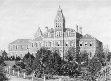 Vision Australia
Photograph - Image, RVIB building in St Kilda Road
The Asylum and School for the Blind, designed by Crouch & Wilson, was built on St Kilda Road in 1868, and later became the Royal Victorian Institute for the Blind. This photograph was most likely taken in the late 19th century, with white posts and wire fencing sectioning the driveway from the garden..B/W photograph of RVIB St Kilda Road buildingroyal victorian institute for the blind, crouch & wilso -
 Whitehorse Historical Society Inc.
Photograph, Area North of Burwood Road near Dandenong Road, 1971
Black and White Photo of Area North of Burwood Road near Dandenong Road.to be entered -
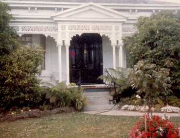 Surrey Hills Historical Society Collection
Photograph, 101 Guildford Road, Surrey Hills
The house was built in 1883, possibly to encourage development of housing on the first urban land subdivision in Surrey Hills, the Windsor Park Estate (in the Windsor Crescent area). This coincided with the opening of the Surrey Hills Railway station. The first occupant was John Brown Nicholson, police magistrate. In 1884 the foundation meeting of the Wyclif Congregational Church was held in the house.Colour photo of the front door and verandah of 101 Guildford Road taken from the street. The house is Victorian in style with ornate lacework along the verandah. It is painted white and has a slate roof. There is a well-maintained garden with flower beds and shrubs, which partially obscure the house.victorian style, wyclif church, houses, guildford road, john brown nicholson -
 Surrey Hills Historical Society Collection
Photograph, Tavistock at 192 Union Road, 1978
The date is approximate. Tavistock was built c1890. The side windows on the front room are a later addition in a different style from the original windows. In 1897 it was the home of the Walker family; Joyce Walker later became matron of Mosgiel Hospital. In 1902 it became the first site of Milverton Girls School. From 1930s to 1960s it was home to Miss Marjorie Vahland, a locally well-known nursing sister. See History Walks No 5, p 11 and p32 Surrey Hills In Celebration of its Centennial 1883-1983Colour photo of the north side of Tavistock at 192 Union Road, Surrey Hills revealed when this side of the property was partially without a fence; taken while re-fencing. The house is Victorian in style, of red brick construction with a patterned slate tile roof and decorative chimneys.tavistock, milverton girls school, victorian style, houses, joyce walker, miss marjorie vahland, nurses -
 Eltham District Historical Society Inc
Photograph, Looking south along Main Road from Diamond Street Railway Crossing, Eltham, February 1968, Feb 1968
Luck Street enters Main Road from the left behind the Caltex garage. Note the house on right hand land.In February 1968 an unknown person took a series of photos from the Eltham Hotel at Pitt Street heading north along Main Road through the shopping centre to just north of Elsa Court covering the length of the section of Main Road which was duplicated shortly thereafter. Shows the condition and environment of the streesscape of Main Road, Eltham immediately prior to the duplication between Pitt Street and Elsa Court through the shopping centre. Also shows a number of shops and businesses that operated at that time.Black and white photographduplication, eltham, main road, diamond street, railway line, railway crossing, caltex service station, supa-value self service -
 Orbost & District Historical Society
black and white photograph, 1962 (exact); 1962 fifty years reunion
A photograph of the earliest "Back to"/reunion for Orbost Higher Elementary School/Orbost Secondary College.The photo is of ex pupils who were at the school when it was first opened in 1912.People in the photo are Dorice Napier (1st L), J.Irvine,? Cumming, Lexie Nixon, Ila Cowell, Arthur Reynolds, Annie Nixon, Dorothy Cameron, Nina Johnston and Pear Napier(nee Cumming -4th L)It is of Historical significance because apparently it is a photo of the earliest "back to/reunion" for Orbost Secondary College.It is of Social Significance because it is a photograph of people who attended Orbost Secondary School.A black and white photograph of nine ladies and one man standing around a table with a large two- tiered cake on it with candles around the base.Hand written on back, hard to read and some words crossed out- "Earliest Pupils H.E.S.1912.Arthur-Reynolds Nina-Johnston/D.Napier J.Irvine ? Cumming- Lexie Nixon/Ila Cowell/Annie Nixon/Dorothy Cameron,"education-orbost orbost-high-school -
 Eltham District Historical Society Inc
Photograph, Stokes family, Nyora Road, Eltham, c.1952, 1952c
Taken from outside the family home on the southest corner of the intersection of Nyora Road and Pitt Street with Eucalyptus Road, looking northeast across the Stokes Orchard L-R: David, Howard, Beryl (kneeling), Dorothy and Gladys Stokes with Gladys's mother sitting in Gladys's father's car with Spot the dog, Nyora Road, Eltham, c.1952 Frank Stokes first traveled to the district by train in 1944 to find land with the intention to establish an orchard. By chance he met Arthur Bird of Bird Orchard (bounded by Pitt Street, Eucalyptus Road and Wattle Grove) and they got talking over their common interest. Arthur put Frank up for the night and pointed out the land, part of Crown Allotment 15, Section 5, Parish of Nillumbik (CA15) somewhat diagonally opposite Bird Orchard. Frank bought the land and for the next two years would travel by train from Melbourne to Eltham every weekend establishing Stokes Orchard and building a home for his family, which they eventually moved into in 1946. In the mid 1970s the Shire of Eltham divided the orchard up into numerous rate-able parcel lots, which became affordable for Frank. As a consequence Stokes Orchard was turned into a housing development by Macquarie Builders and marketed as the Stokes Orchard Estate in two stages; Stage 1 encompassing Scarlet Ash Court, Ironbark Close and Peppermint Grove bounded by Nyora and Eucalyptus roads c.1976 and Stage 2 encompassing Stokes Place, Orchard Way, The Crest and The Lookout bound by Nyora and Diosma roads c.1979. The development of Orchard Way, The Crest and The Lookout did not proceed as planned due to the lack of the sewer along Diosma Road and so many of the proposed lots were incorporated into five-acre parcels instead.Representative of the orchard growing areas of ElthamDigital file only - Digitised by EDHS from a scrapbook (containing commercially printed photos of digital scans) on loan from Beryl Bradbury (nee Stokes), daughter of Frank Stokes.1948-1951 vauxhall velox, 1948-1951 vauxhall wyvern, 1952, beryl bradbury (nee stokes), beryl bradbury (nee stokes) collection, david stokes, dorothy stokes, eltham, gladys stokes, nyora road, spot (dog), stokes orchard -
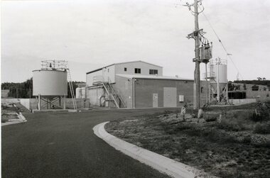 Stawell Historical Society Inc
Photograph, Grampians Wimmera Mallee Water Purification Plant in Crowlands Road
Grampians Wimmera Mallee Water Purification plant. Crowlands Road Stawell.Two different photographs of a building with storage tanks around the building. A power pole in front of the building and beside a curved road.grampians water supply -
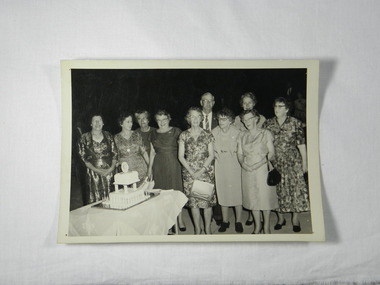
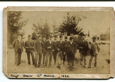 Orbost & District Historical Society
Photograph, March 13 1892
This photograph shows members of the first Orbost Agricultural Show committee.. The first meeting to form an Agricultural society in Orbost was convened by the then Orbost Progress Association and held in the Mechanics Hall on Saturday, 10th October 1891. Its first show was held on 3rd March 1904...on a site alongside the Bonang Road where the present Golf Club stands. It is currently held at the Recreation Reserve at Newmerella. (Ref: In Times Gone By-Deborah Hall) This item is associated with the Orbost Agricultural Society 's Annual Show which has been a major event in Orbost for over a century. Agricultural shows are an important part of cultural life in small country towns and the Orbost Show is an integral part of Orbost 's agricultural history.A sepia photograph of eleven men, wearing suits and waistcoats, standing on a vacant block of land. In the background are houses among tress. The photograph is mounted on grey card - rectangular with rounded corners.on back -"Toby Nixon" on front - "First Show 13th March 1892"orbost-agricultural-society annual-show-orbost agriculture-orbost -
 Eltham District Historical Society Inc
Photograph, M. North, Main Road, Eltham near Fitzsimons Lane Roundabout, Dec 1985, 1/12/85
Two colour photographs of Main Road, ElthamSouth between Falkiner Street and Bolton Street at the roundabout of Fitzsimons Lane, Eltham, Dec 1985Noted on 463B 'See 1934 small black and white snap of flooded bridge and the same two shops. This snap taken from same location, Dec 1985. Old Eltham Park on right of photo The two shops at left (Ansel and Muir) Road ahead crosses new bridge over the Diamond Creek, Eltham Main Road now dual highway, through Lower Plenty to this bridge'main road, eltham, eltham south, fitzsimons lane, round about, falkiner street -
 Greensborough Historical Society
Photograph - Digital Image, Marilyn Smith, Greensborough Grain Store, 183 Para Road. Interior, 2016_04
This photograph shows the interior of the building at 183 Para Road when it was used for Greensborough Grain Store; this photo was taken in April 2016.In 2017, the Greensborough Grain Store closed its Para Road premises and now trades online.Digital copy of colour photographgreensborough grain store, para road greensborough -
 Eltham District Historical Society Inc
Photograph, Looking northwest acroos Main Road from near Arthur Street, Eltham, February 1968, Feb 1968
Shows the car parking on the west side of Main Road, part of the Post Office on left and the pedestrian crossing from the railway station.In February 1968 an unknown person took a series of photos from the Eltham Hotel at Pitt Street heading north along Main Road through the shopping centre to just north of Elsa Court covering the length of the section of Main Road which was duplicated shortly thereafter. Shows the condition and environment of the streesscape of Main Road, Eltham immediately prior to the duplication between Pitt Street and Elsa Court through the shopping centre. Also shows a number of shops and businesses that operated at that time.Black and white photographduplication, eltham, main road, carparks, railway station, post office -
 Glen Eira Historical Society
Album - Album page, Myoora, 405 Alma Road, Circa 1972
This photograph is part of the Caulfield Historical Album 1972. This album was created in approximately 1972 as part of a project by the Caulfield Historical Society to assist in identifying buildings worthy of preservation. The album is related to a Survey the Caulfield Historical Society developed in collaboration with the National Trust of Australia (Victoria) and Caulfield City Council to identify historic buildings within the City of Caulfield that warranted the protection of a National Trust Classification. Principal photographer thought to be Trevor Hart, member of Caulfield Historical Society. Most photographs were taken between 1966-1972 with a small number of photographs being older and from unknown sources. All photographs are black and white except where stated, with 386 photographs over 198 pages.Victorian Heritage Register (VHR) Number H0490 From the Victorian Heritage Register Database - Citation for Myoora https://vhd.heritagecouncil.vic.gov.au/places/275 (as at 6/10/2020) Myoora, 405 Alma Road, North Caulfield, was designed by Reed, Henderson & Smart and can be attributed to Anketell Henderson. It was built in 1886 and 1887 for Thomas Christian, who had founded the fabled gold mine, the Day Dawn at Charters Towers. He never occupied the house although his widow lived there for some time. The house was subdivided into three and later six flats. Myoora was one of many large mansions on broad acres with gardens in Caulfield. Perhaps the grandest was Labassa. The mansions date from the 1850s through to the late 1890s. The siting of Myoora on a ridge influenced its planning and composition. A central hall and corridor along the ridge is entered from the centre of the more formal north facade. The entrance is marked by an elaborately detailed tower. A stair turret provides a second accent. The western end of the building is completed by a massively detailed chimney as the service wing. The south facade enjoyed an outlook to Port Phillip from a two-storey cast iron verandah. Bay windows, chimneys, the tower and the turret and minor details are brought together in a sophisticated asymmetrical composition. This is reflected in the planning. The asymmetry of Myoora pivoting on the tower is the most notable feature of the building. The walls are built of cement rendered brick. The cement render has not been painted. The roof is slate. The balconies and verandah are cast iron. The footings and cellar are bluestone. The architectural firm Reed, Henderson & Smart was very prominent in Victoria in the nineteenth century. Anketell Henderson was an eminent and well respected member of the profession. He worked successfully in London and interstate as well as in Victoria. They were better known for commercial and public buildings. Myoora is an important private commission. The style of Myoora is a combination of details from the Continental and English Renaissance through the boom style and the Queen Anne style. There is also an early influence from the American Romanesque style especially in the stair turret. The latter style was important at the turn of the century and Myoora is a significant precursor. Other buildings of a similar scale survive in Caulfield and elsewhere. Labassa, the most fabulous, is quite different stylistically as are most of the other comparable mansions. Stonnington is perhaps closer but relies on different details from the Queen Anne style and lacks any American influence. For its historical associations through its owners and architects, for its style and composition and for its intactness, Myoora is significant at a State level. The craftmanship of Myoora is what could be expected of a building of the time and type. It is relatively intact and in fair condition. The main staircase has been removed, minor alterations to decorative features have occurred and additions have been made to the exterior.Page 16 of Photograph Album including three black and white photographs. Two are arranged in landscape orientation on the right hand side of the page with the other photo in portrait mode on the left hand side. Handwritten: views from "Myoora" 405 Alma Road [top right] / Neg 181 Dec 1972 [under left side photo] / Neg 189 Dec 1972 [under bottom right photo] / 16 [bottom right]caulfield north, trevor hart, alma road, mansion, myoora, tower, thomas christian, 1880's, queen anne, cement rendered brick, unpainted, balconies, verandahs, anketell henderson, continental and english renaissance, american romanesque, cast iron balconies, panoramic views, streetscapes, cast iron work, reed henderson & smart, gardens, asymmetrical style, slate roofs, chimneys -
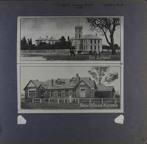 Glen Eira Historical Society
Album - Album page, Caulfield Grammar School, Glen Eira Road, Circa 1972
This photograph is part of the Caulfield Historical Album 1972. This album was created in approximately 1972 as part of a project by the Caulfield Historical Society to assist in identifying buildings worthy of preservation. The album is related to a Survey the Caulfield Historical Society developed in collaboration with the National Trust of Australia (Victoria) and Caulfield City Council to identify historic buildings within the City of Caulfield that warranted the protection of a National Trust Classification. Principal photographer thought to be Trevor Hart, member of Caulfield Historical Society. Most photographs were taken between 1966-1972 with a small number of photographs being older and from unknown sources. All photographs are black and white except where stated, with 386 photographs over 198 pages. In 1881, Reverend J H Davies founded Caulfield Grammar School in Elsternwick, Victoria with just nine students.Page 54 of Photograph Album with one photograph of two images of Caulfield Grammar School. The images are vertically arranged and joining.Hand written: Caulfield Grammar School / 1909 [middle top] / Glen Eira Road [top right ]/ 54 [bottom right]. Top image includes a printed title "Old School" and the bottom image "New Class Rooms".trevor hart, 1880's, 1890's, elsternwick, caulfield grammar school, reverend j h davies, education, glen eira road, st kilda east, church of england, double storey school buildings -
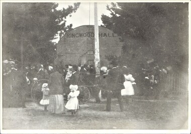 Ringwood and District Historical Society
Photograph, Ringwood Hall, Mount Dandenong Road, Ringwood - circa 1900, Circa 1900
Ringwood Hall was located near the Club Hotel in Mount Dandenong Road prior to construction of Mechanics Institute/Town Hall in Maroondah Highway in 1909.Black & white photo of crowd gathered at original Ringwood Hall, Mount Dandenong Road, Ringwood. "Old Ringwood Hall nr. Club Hotel, later burnt down approx 1909". "Old Ringwood Hall prior to Mech Inst of 1909". -
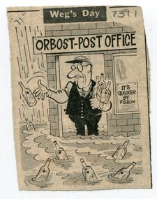 Orbost & District Historical Society
newspaper clippings, February 1971
These articles were compiled by Mary Gilbert who was the first curator of the Orbost Museum and a prominent historian / teacher in Orbost. The 1971 floods at Orbost were the worst on record. At Jarrahmond the river rose to a height of 11 metres and on the flats spread to one and a half kilometres wide. Considerable damage was done to railway infrastructure, roads and farms. More information from the APRIL, 2008 newsletter by John Phillips. (see orbosthistory.com.au)These articles are contemporary records of a significant historical event in Orbost.A manila folder containing black / white newspaper clippings from various publishers. They all relate to the 1971 floods in Orbost. (Details of contents in catalogue 735-900)floods-orbost-1971