Showing 10750 items
matching plan
-
 Melbourne Tram Museum
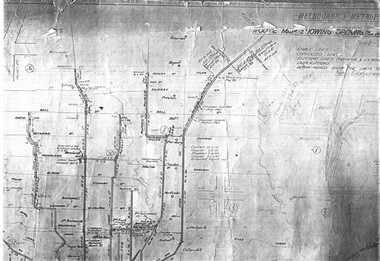
Drawing, Melbourne & Metropolitan Tramways Board (MMTB), "Plan of Tramway System - showing route mileage of electric tramways", Late 1960's
Set of 9 A3 photocopy of a drawing - of a dyeline print that had been mounted onto a cloth backing and had been kept up to date with regard to extensions and closures or opening and closing - titled - "Plan of Tramway System - showing route mileage of electric tramways" - Principal Junctions and intersections shown diagrammatically. Map of system shown at 40 chains to the inch. Copy of Drawing No. P6050. Shows crossovers, signal cabins, automatic points, closed cable tram lines in the city area, Port Melbourne, roads, railways and stations. Has extensions to Mill Park up to April 1987. Shows the Port Melbourne, North Melbourne (Spencer and Abbotsford Sts) and Collingwood cable lines, the Footscray system lines and the Point Ormond lines. See also Reg Item 1561 for a late 1960's print and 3642 for a 1941 version.trams, tramways, mmtb, trackwork, tramways, junction, map -
 Port Melbourne Historical & Preservation Society
Plan - Street levels, c. 1862
Drawn up to replace rescinded portions of street plan of March 1862.Plan of street levelsDetails and signatures as belowengineering - roads streets lanes and footpaths, frederick william bull, thomas swallow, edward clark, town clerks -
 Federation University Historical Collection
Plan, Burrumbeep, 1884, 16/10/1884
Auctions of Crown land were introduced in the Colony of Victoria from 1851 to encourage settlers to occupy and work the land. Many squatters purchased land at auction at the upset (minimum) price of £1 per acre. In some areas where demand was high, such as the goldfields, the price realised at auction was much more. Land was put up for sale in the study area on the Burrumbeep run in May 1855, on the Lexington run in 1857, and on the Gorrinn run in 1858. (http://www.ararat.vic.gov.au/library/document/thermatics.pdf, accessed 27 January 2015) For 70 years or more, Yalla-y-Poora, Burrumbeep, Edgarley, Mount William and Narrapumelap ranked in the leading wool producers in Victoria. 1 Stud owners at Yalla-y-Poora, Eurambeen, Burrumbeep and Challicum crossed merino sheep with sheep descended from John Macarthur's Camden Park in New South Wales. (http://www.ararat.vic.gov.au/library/document/thermatics.pdf, accessed 27 January 2015) In what was to become the Ararat Mining Division, gold was discovered in May 1854 on the Burrumbeep run at a place that became known as Pinky Point on the Mount William goldfield. By 21 June 1854, between 600 and 1,000 people had arrived. (http://www.ararat.vic.gov.au/library/document/thermatics.pdf, accessed 27 January 2015)\ Town allotment plan for Burrumbeep. Merrymbuela, Borung, Lexington and Langi Logan are neighbouring areas. The plan includes the Burrumbeep Pre-Emptive Right (Roger and Wright); licensed land holders including Stephen Young, John Carroll, William Walsh, Thomas Purcell, Martha M. Bond, Colin Johnson, John Charles Webb, Henry Withycombe, William Henry Barbridge, John Wall, Thomas Flatelly, William Jenkinson, Elisia Radford, V. Radford, Denis Byrne, George Cook. Land holders included Andrew Maloney, Richard Wingfield Harrocks, W. Sporton, Terence Lynch, F. S. Falkiner, A. Millman, H. Morris, George Upham, J. McCLure, S. Fletcher, W. Parker, Thomas Myers, William wright, W.C. Winter, C. Wordman, Oliver A. Winter This plan is associated with former Ballarat School of Mines student Richard Squire (1875-6) Gift of the Squire FamilyVerso written in pencil - Plan of Burrembeep Ararat Burrembeep Araratburrumbeep, corrinn, langi logan, merrymbuela, lexington, ararat, roger & wright, cook, rogers, upham, george upham, ross, parsans, morris, johnson, withycoombe, colin johnson, falkiner, dsporton, john carroll, donald gordon, denis bryne, maurice dooley, martha bond, william harricks, \william wingfield harricks, william l.c. harricks, michael houlihan, thomas purcell, martin ryan, michael cody, fletcher, mccaw, w. parker, j.m. clow, elisia radford, thomas radford, thomas myers, barbridge, e. wilde, j. wall, flatelly, g. wardman, w.c. winter, david ball, jenkinson, ballarat school of mines, richard squire, squire -
 Melbourne Tram Museum
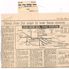
Newspaper, The Age, The Herald, Michael Venus, Gerry Carman, "Steep rises for some in new fares system", "Train, tram Fares Shake up - one - ticket travel plan", 17 and 18/9/1981
.1 - Newspaper cutting from The Age 18/9/1981, titled "Steep rises for some in new fares system", about the introduction of a new public transport fare system into Melbourne - 3 zones, Travel cards - refers to the coloured brochure - "The new train, tram and bus ticket system (see Reg Item 433) - includes a map of the rail system showing the various zones. Written by Gerry Carman .2 - Newspaper cutting from The Herald, 17/9/1981, titled "Train, tram Fares Shake up - one - ticket travel plan", item. Gives a description of the new system. Item written by Michael Venus. Consists of two parts - from another page - stapled in the top left hand corner. Cuttings has the Aust. Press Cuttings Agency source sheet pasted to the top right hand corner along with the paper name and date stamp.Has in pencil at top of cutting "Trams/Ballarat Trams"trams, tramways, fares, tickets, travel cards, buses, mmtb, vicrail -
 Bendigo Historical Society Inc.
Plan - FORTUNA COLLECTION: FORTUNA VILLA
Originally built by Christopher Ballestedt (1796-1869) and his son Theodore. The Ballestedt's pioneered open cut and quartz mining on the Bendigo gold field. They were very successful. After Christopher's death, Theodore continued until 1871 when he sold Fortuna, their mines and equipment to George Lansell for 30,000 pounds.Four large plans of Fortuna villa. Scale 1:50 Australian survey office - Victoria Department of Administrative services. Fortuna Bendigo - Army Survey Regiment. Dept. of Defence - Army. Terrestrial Photogrammetric Survey. Project number: 8001/2. Reg. File: 64/531. Survey File:631. Draftsman: M.A. Osciak. Surveyed by G. Tucker. Date of Survey: 14/05/79. There are 4 large such plans in a plastic bag the measurement of the plans is approx. 115cm X 80 cm.plan, bendigo, fortuna villa -
Port Melbourne Historical & Preservation Society
Plan - CD-ROM, "State Bank of Victoria - Proposed dwelling Fishermans Bend"
Plans were brought to us by CBA employee Steve Tserkezidis CD with items below. From series of State Bankhouse plans and elevations of types 1 - 8. A1 copies (.01) 1937 (stamp). (.02) 1928. (.03) 1937. (.04) 1937. (.05) no date. (.06) 1928. (.07) 1937. (.08) 1938. From plans accompanying bank House plans .01 to .08; (.09) MMBW plan showing bank properties (.10) Bank house plan: sections through walls. (.11) "Fishermans bend group" plan of properties (.12) Bank House plan of Pier Foundationgarden city, built environment - domestic, state savings bank of victoria, bank houses -
 Bacchus Marsh & District Historical Society
Map, Atkins and Clarke Land Sale situate at Bacchus Marsh 1856 Copy 2
This plan of land allotments for sale indicates the property once owned by the Bacchus family in and around the township area of Bacchus Marsh. The Bacchus family sold their property in Bacchus Marsh to John Atkins and Robert Nalder Clarke in March 1851. Atkins and Clarke kept the property for a number of years until April 1856 when these allotments were put up for sale.This plan is almost identical to another copy held by the Bacchus Marsh and District Historical Society, VC Record 707, BMDHS collection). This plan, VC Record 452 Copy 2, contains a less detail than than VC Record 707 Copy 1. For example the selling agents and the surveyor who created the plan are not indicated on this copy of the plan. This copy of the plan does indicate the name Crook Street on the map. As the Crook family were the buyers of the Manor House property and surrounding land from Atkins and Clarke in 1856 it suggests that this copy is a later one of the earlier version. It is unlikely that the Crook family would have had the adjacent street named after them prior to purchasing the house and property. This is a very early land sales plan for the township of Bacchus Marsh and it therefore provides some clues as to how the early urban development of the township took place. Upon seeing the map in 1911 Bacchus Marsh Express newspaper editor Christopher Crisp wrote "The sale appears to have created the present township, which had a nucleus in earlier times further east", Express, 30 September, 1911, page 3. A single page paper map showing a portions of land available for sale in Bacchus Marsh in 1856. The subdivided land shown was owned by John Atkins and Robert Nalder Clarke, but previously owned by the Bacchus Family and was in and around their Manor House (Mansion) property in Bacchus Marsh.There are 5 portions of land further divided into numerous small portions. The land for sale is bounded by the present day streets of Main Street, Young Street, McFarland Street, Morton Streets, Crook Street, and part of the eastern section extends to the Lerderderg River. Scale: 4 chains to 1 inch. The map is pasted into a bound volume containing 76 maps or plans in total. High resolution digital image stored on BMDHS computer network. Plan of the first portion of land. The property of Messers Atkins and Clarke situate at Bacchus Marsh.land sales, land sales bacchus marsh, manor house bacchus marsh, crook family bacchus marsh -
 Ballarat Tramway Museum
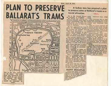
Newspaper, The Courier Ballarat, "Plan to Preserve Ballarat's trams", "Horse drawn trams may be revived for tourists", 28/04/1971 12:00:00 AM
Two Newspaper clippings pasted onto a single sheet of paper with two Punch holes on the left hand side, with one hole through each cutting. First clipping from The Courier, Ballarat, Monday, 28/4/1971 about a plan by Mr Donald Fraser of Lindfield (NSW) to retain the tramway around Lake Wendouree and use Sturt St. as well as Ripon St. Item has map (see image) showing the proposed route and some comments about tramway museums, museums in general and static preservation. Part of the item in the first column is missing. Second cutting dated 3/5/1971 with headline about the possible revival of horse drawn trams in Ballarat. Item also looks at Council's Tourism Committee considerations for retaining trams in Ballarat, relaying lines, reconditioning overhead, looks at costs of running horse drawn trams versus electric trams. Quotes Cr. J.Chisholm, Committee chairman. 1072.2 - duplicate of second cutting added 26/2/2017 from donation of Ruth NelsonIn red ink in upper right hand corner of first cutting "28/4/71" and in upper left hand corner of second, in pencil, "3/5/71". On rear has various pencil marks from former use at perhaps Donor's employer, Ronaldson and Tippet. 1072.2 - in ink on top edge "Courier 3/5/71"trams, tramways, lake wendouree tramway, horse trams, museum establishment, tramway museums -
Port Melbourne Historical & Preservation Society
Document - Specifications, Additions, Port Melbourne Town Hall, City of Port Melbourne, 8 Jun 1936
Specification for additions etc. to supper room at Town Hall, Port Melbourne, 1936 - included with plans, consisting of three typewritten foolscap pages of notes.Both notes and plan signed by F.C. Cook, City Engineer - 3rd page of notes, top left hand corner of plan.port melbourne town hall, city engineers, fred cook -
 Federation University Historical Collection
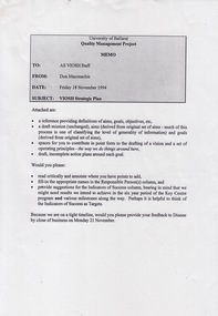
Document - Document - Project, VIOSH: University of Ballarat, Strategic Plan; Quality Management Project 1994
Victorian Institute of Occupational Safety and Health (VIOSH) Australia is the Asia-Pacific centre for teaching and research in occupational health and safety (OHS) and is known as one of Australia's leaders on the field. VIOSH has a global reputation for its innovative approach within the field of OHS management. VIOSH had its first intake of students in 1979. At that time the Institution was known as the Ballarat College of Advanced Education. In 1990 it became known as Ballarat University College, then in 1994 as University of Ballarat. It was 2014 that it became Federation University. VIOSH Australia students are safety managers, senior advisors and experienced OHS professionals. They come from all over Australia and industry. Students are taught active research and enquiry; rather than textbook learning and a one-size fits all approach. VIOSH accepts people into the Graduate Diploma of Occupational Hazard Management who have no undergraduate degree - on the basis of extensive work experience and knowledge. Memo from Don Maconachie was sent to all VIOSH Staff in relation to the development of a VIOSH Strategic Plan. They were to develop value statement, vision statement, aims, goals, objectives, targets, strategies. Staff provided with forms to be completed coving these aspects. They were to state the responsible person, timeline, target groups, resources required and indicators of success. On completion results compiled and given to staff. Report would then be sent to Director of VIOSH Australia.Forty-two pages that was stapled together in sections. Type written with relevant charts.viosh, victorian institute of occupational safety and health, quality management project, visor strategic plan, don maconachie, mission statement, aims, targets, director -
 Federation University Historical Collection
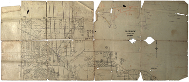
Plan, Creswick, County of Talbot
This plan is associated with former Ballarat School of Mines Student Richard Squire (1875-1876). Gift of the Squire Family, 2014 Plan showing allotments in Creswick, County of Talbot. The plan is in a number of pieces with some sections missing.creswick, creswick creek, spring hill, sarah paterson, lehman, mullins, spittle, squire, richard squire -
Bendigo Historical Society Inc.
Plan - SANDHURST BOYS CENTRE SITE PLANS: LISLE STREET UNITS
16 Working drawings including Floor Plans and Elevations Prepared by Michael DeVincentis, Architects; Wellington St Strathfieldsaye. October-November 1995. Scale 1:200. No 9538. Also Survey Plan for Lot 69D 3950 Sq m. Location unknown 16.02.2023.plan, bendigo, institutions, victoria. department of planning and development -
Stawell Historical Society Inc
Map, R.O. Robson - Authorised Surveyor, Road from Glenorchy to near Geary's Selection Callawaddy 1880, 29.04.1880
Survey for Road CreationCloth Backed Map. Plan of Road.Parishes of Richella & Callawadda. County of Borong. Plan of Road. R.O. Robson Authorised Surveyor Stawell 29.04.80 -
 Kew Historical Society Inc
Plan - Subdivision : Cotham and Glenferrie Roads, J R Mathers & McMillan
The Kew Historical Society's map collection includes a substantial number of real estate subdivision plans, mainly of Kew but also of surrounding suburbs in Melbourne. Most of the subdivision plans date from the 1920s and 1930s when the districts old homes and local farmland were being split up to accommodate residential growth in the postwar period. These early plans were assembled by a local firm, Jas R Mather & McMillan, which had an office in Cotham Road. Many of the plans, and sometimes photos, were annotated by the agents.Subdivision plans are historically important documents used as evidence for the growth of suburbs in Australia. They frequently provide information about when the land was sold as well as evidence relating to surveyors and real estate and financial agents. The numerous subdivision plans in the Kew Historical Society's collection represent working documents, ranging from the initial sketches made in planning a subdivision to printed plans on which auctioneers or agents listed the prices for which individual lots were sold. In a number of cases, the reverse of a subdivision plan in the collection includes a photograph of a house that was also for sale by the agent. These photographs provide significant heritage information relating house design and decoration, fencing and household gardens.The photograph may also be aesthetically significant depending on the importance of the photographic atelier.An undated and untitled hand-drawn and coloured subdivision plan detailing the boundaries of a number of irregular allotments bordering Cotham Road, Glenferrie Road and Stirling Avenue (now Stirling Street). The plan predates the actual subdivision that led to the creation of the eight commercial properties occupying 118-132 Cotham Road. The plan may represent an old subdivision that was further subdivided at a later date, or it may be a subdivision that never eventuated. On MMBW Detail Plan 1575 (1903), the area represented by the proposed subdivision was residential rather than commercial. The irregularity of lots is also apparent in the MMBW Plan. The largest of the unnumbered blocks on the hand-drawn subdivision plan may relate to the boundaries of the nineteenth century mansion identified as ‘Kelso’ on the MMBW Plan.subdivision plans - kew, cotham road - kew,, glenferrie road - kew , stirling avenue street - kew -
 Warrnambool and District Historical Society Inc.
Documents, WCC Proposed turntable site railway station, 1968; 1989
These two plans are copies and show drawings for a proposed turntable at the Warrnambool Railway Station and railway crossings at Gilles Street in the Liebig Street precinct. The Warrnambool Railway was opened in 1890 and the Warrnambool Railway Station building was erected a few years later. These plans, being copies, are of minor interest as they show plans of some projects in the Warrnambool Railway Station precinct in the latter half of the 20th century.These are two sheets of cream-coloured paper with plans (copies of original) drawn up in black ink. The drawings are fading somewhat and are faint in places. One sheet (.2) has a piece missing from the top left hand corner. .1 ‘Locality Plan of Rail Crossings Liebig St. & Gillies (sic) St.’ .2 ‘Proposed Turntable Site Warrnambool Railway Station’ plans, warrnambool railway, warrnambool rail turntable -
 Mission to Seafarers Victoria
Plan - Architectural drawings, Walter Butler, New Missions to Seamen Institute Buildings Melbourne, 1916
In August 1916, Walter R. Butler presented the plans for the future central Seamen's Institute.The drawings show the original plans with rooms' names and intended use. They also show the original concept for the chapel which was in the Spanish Mission style.Plan copied from the 1983 Howden and Wardrop A4 report. A large plan copy of the original is held in the MSTV archives.flinders street, mission to seamen, mission to seafarers, walter richmond butler (1864–1949), norla dome, st peter chapel, spanish mission, arts and crafts, 1916 -
Bendigo Historical Society Inc.
Map - FRED COWIE COLLECTION: AERIAL MAPS OF HEATHCOTE/EPPALOCK, 28-9-1960
Map, Heathcote C2, Township of Heathcote, Melbourne Road through town branching off to Bendigo & Echuca. Aerial Survey of Victoria. Photo-map prepared by Department of Crown Lands and Survey from photographs taken in 1960. Copied photographically at the Central Plan Office.Fred Cowie,46 McIvor Rd,Bgo..Central Plan Officemap -
Bendigo Historical Society Inc.
Map - FRED COWIE COLLECTION: AERIAL MAPS OF HEATHCOTE/EPPALOCK, 28-9-60
Map, Heathcote C4, Aerial Survey of Victoria,Photo-map prepared by Department of Crown Lands and Survey from photographs taken in 1960. Copied photographically at the Central Plan Office.Date 28-9-60,C.P.O.Neg.No.21590.Scale 4 inches to 1 mile. Fred Cowie,46 McIvor Rd,Bgo..Central Plan Office.map -
Creswick Campus Historical Collection - University of Melbourne
Document, unknown
School of Forestry existing services and condition plans, Building plans. Extension plansBuilding Plans -
Glenelg Shire Council Cultural Collection
Plan - Town Plan - Cape Bridgewater, 02/04/1992
Black and white photocopy of an old plan of a subdivision at Cape Bridgewater. Two halves joined together with sellotape. Black texta numbers on some of the lots 1 - 28Front: 'OLD MAP' handwritten, top edgeplan, town planning, cape bridgewater -
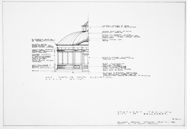
 Friends of Ballarat Botanical Gardens History Group
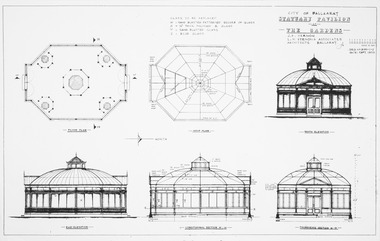
Plan, J.B Vernon et al, City of Ballaarat Statuary Pavilion at the Gardens, September 1970
Sections, elevations and floor plan for pavilionPhotocopyplan, drawings, statuary pavilion -
 Friends of Ballarat Botanical Gardens History Group
Plan, J.B Vernon et al, City of Ballaarat Statuary Pavilion at the Gardens - Part B, September 1970
Sections, elevations and floor plan for pavilionPhotocopyplan, drawings, statuary pavilion -
Bendigo Historical Society Inc.
Map - FRED COWIE COLLECTION: AERIAL MAPS OF HEATHCOTE/EPPALOCK, 28-9-60
Map, Heathcote C3, Aerial Survey of Victoria, Photo-map prepared by Department of Crown Lands and Survey from photographs taken in 1960.Copied photographically at the Central Plan Office. Date 28-9 60, C.P.O.Neg. No.21588.Campaspe River, Coliban River. Flower Hill. Fred Cowie,46 McIvor Rd.Bendigo (Not located 29.9.2022)Central Plan Office.map -
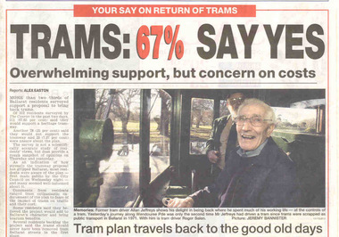 Ballarat Tramway Museum
Newspaper, The Courier Ballarat, "Trams: 67% Say Yes", "Put tram plan to the vote", "Lets make sure we all get on the right tram", "Trams would be bad for mall: manager", 13/07/2002 12:00:00 AM
Set of four cuttings from The Courier, Ballarat dated Saturday 13/7/2002 regarding the reintroduction of trams to Ballarat. 2239.1 - Front page with caption "Trams: 67% Say Yes", written by Alex Easton regarding a survey of 312 residents by the Courier. Also has a photo by Jeremy Bannister of former tram driver Alan Jeffreys at the controls of a tram in Wendouree Parade with Roger Salen in the background. 2239.2 - page 9 - Editorial written by Stuart Howie titled "Lets make sure we all get on the right tram" discussing the positive and negative attributes and problems of spending a large amount of money to return trams to Ballarat. Has a digitally composed photo of No. 13 in Lydiard St. North, showing destination "CITY" and a photo of the Eureka Stockade. 2239.3 - Page 4 - lead article titled "Trams would be bad for mall: manager", written by Alex Easton quoting David Nolan and the impact of trams on the mall, along with a cartoon about a tram ticketing machine being out of order. Cartoon by inkcinct. Also continues from page 1, lead article. Notes that readers can have they say on a web poll. 2239.4 - Page 8 - Letter to the Editor, by William J Hoath titled "Put tram plan to the vote", asking for any tram proposal to be put to the vote of ratepayers. Also on the side in a column titled "Short Takes", titled "Link lake to the tram line", provided by Joan C. Ryan of Ballarat.ballarat revival, letter to the editor, ballarat city tramway, lydiard st. nth -
 Glen Eira City Council History and Heritage Collection
Book, "Report to the Post War Planning Committee, Caulfield City Council"
The Post War Planning Report was prepared by Leslie M. Perrott & Partners: (City Planning Consultants) and according to the report, it was submitted to the Council of the Municipality of Caulfield through its Special Committee on Post War Planning. The report has no evident date however the introduction text suggests that it was prepared before the end of World War II. The report is the only known extant copy and therefore considered rare. Bound report with grey cover titled: "Report to the Post War Planning Committee Caulfield City Council". Interior pages include x83 pages typed text printed on blue print paper; x3 pages copies of black and white photographs; 10 blueprint plans. 86 pages consistent in size with book cover, 10 x blueprint plans varying dimensions, folded and bound within the report. Printed on white sticker on spine of book "LH 994. 51" and on first page inside "CAULFIELD LIBRARY SERVICE REFERENCE BOOK" and on the verso of this page, another stamp with CAULFIELD LIBRARY SERVICE and LH REF 12/7 hand written in black ink and a 14 digit reference number below this. On the back of the last plan in the book, there is a blue stamp with "REFERENCE BOOK TO BE USED IN THE LIBRARY ONLY". Below this is a black and white barcode with a black line through it and a round, blue sticker beside it. -
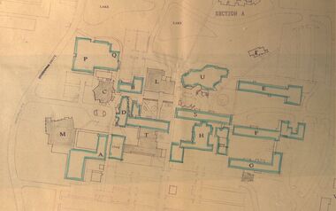 Federation University Historical Collection
Plan - Site Plan, Mount Helen Campus Academic area
Federation University site plan made for the Ballarat College of Advanced Education Printed architectural plan of the Mount Helen campusprinted with location names and symbolssite plan, federation university, ballarat college of advanced education, mount helen campus, campus plan -
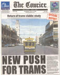 Ballarat Tramway Museum
Newspaper, The Courier Ballarat, "Return of trams viable study", "New Push for Trams", "Taking tourism to the next level", "More tourists, more jobs expected", "Tram plan worthy of expected debate", 11/07/2002 12:00:00 AM
Set of three cuttings from The Courier, Ballarat dated Thursday 11/7/2002 regarding the reintroduction of trams to Ballarat. 2241.1 - Page 1 and 2 of The Courier, with page 1 titled "Return of trams viable study" and "New Push for Trams" as the commencement of a Special report showing a digitally constructed image of No. 13 in Lydiard St. North. Note the tram does not have a driver. Introduces reports by Alex Easton on pages 2, 6 and 7. On Page 2, titled "Taking tourism to the next level", has details of the Council viewpoints on the proposal, public consultation, a map of the route, and notes on the construction issues. Has a digital image of 13 crossing Sturt St. into Lydiard St. North. See images No. 1 to 3. 2241.2 - page 6 of The Courier, which joins with page 7 using the titled "More tourists, more jobs expected". Has Sections reviewing the study outcomes, benefits and a summary of the study. Page 6 has a photo of a passenger boarding No. 21, decorated as the Myers Christmas tram in Sturt St and a photo of Bridge St. in 1971 (very poor quality reproduction). See images No. 4 and 5. 2241.3 - page 7 of The Courier, has Sections detailing the history of Ballarat Trams, proposals for the City Tramway, costs, consultation, and comments from Peter Hiscock. Has a photo of Peter Hiscock and Mayor David Vendy in front of No. 13 at the BTM depot. See image No. 6. Also has a photo of Dianne Smith, Executive Director of Ballarat Tourism. On page 8, as part of The Courier's editorial Section, has comments on the proposals, titled "Tram plan worth of extended debate". Looks at the $20million cost. ballarat revival, editorial, ballarat city tramway, lydiard st. nth -
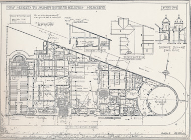 Mission to Seafarers Victoria
Plan - Architectural drawings, Walter Butler, New Missions to Seamen Institute Buildings Melbourne, 1916
In August 1916, Walter R. Butler presented the plans for the future central Seamen's Institute.The drawings show the original plans with rooms' names and intended use. They also show the original concept for the chapel which was in the Spanish Mission style.Plan copied from the 1983 Howden and Wardrop A4 report. A large plan on tracing paper (original or copy of the original) is held in the MSTV archives.flinders street, mission to seamen, mission to seafarers, walter richmond butler (1864–1949), norla dome, st peter chapel, spanish mission, arts and crafts, 1916 -
 Kew Historical Society Inc
Plan - Subdivision Plan, Argyle Road, Heather Grove, Victor Avenue, Kew, c.1937
The Kew Historical Society's map collection includes a substantial number of real estate subdivision plans, mainly of Kew but also of surrounding suburbs in Melbourne. Most of the subdivision plans date from the 1920s and 1930s when the districts old homes and local farmland were being split up to accommodate residential growth in the postwar period. These early plans were assembled by a local firm, Jas R Mather & McMillan, which had an office in Cotham Road. Many of the plans, and sometimes photos, were annotated by the agents.Subdivision plans are historically important documents used as evidence for the growth of suburbs in Australia. They frequently provide information about when the land was sold as well as evidence relating to surveyors and real estate and financial agents. The numerous subdivision plans in the Kew Historical Society's collection represent working documents, ranging from the initial sketches made in planning a subdivision to printed plans on which auctioneers or agents listed the prices for which individual lots were sold. In a number of cases, the reverse of a subdivision plan in the collection includes a photograph of a house that was also for sale by the agent. These photographs provide significant heritage information relating house design and decoration, fencing and household gardens.The photograph may also be aesthetically significant depending on the importance of the photographic atelier.Undated blue subdivision plan in Kew of 14 lots facing Argyle Road, Heather Grove and Victor Road. The Plan identifies Tuxen & Miller as the surveyors. [Formerly catalogued as MAP.0059]subdivision plans - kew, argyle road - kew, heather grove - kew, victor avenue - kew -
Port Melbourne Historical & Preservation Society
Plan - Proposed footbridge over the Lagoon, Bridge Street, Port Melbourne, 1863
Plan of proposed footbridge over the Lagoon in line of Bridge StreetIn ink on reverse, two small drawings: elevation land view over a distance of 25.00 chains (colour tinted), and Plan view, section of an unidentified street:In pencil on reverse, notation '107 Albert Street'sandridge lagoon, robert h morgan