Showing 3207 items
matching road map
-
 Ringwood and District Historical Society
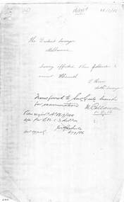
Document - Copy of Lands Department Field Notes - Ringwood, Victoria, Field Notes 86.87/108 - Survey O.P. R72A dated August 1886 by Surveyor, L. Thorn
Foolscap size photocopies of survey maps with handwritten notations. -
 Ringwood and District Historical Society
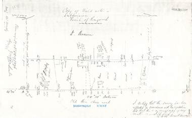
Document - Copy of Lands Department Field Notes - Parish of Ringwood, Victoria, Field Notes 88-9/276 - Part of O.P. R72C surveyed 12.10.1888
Foolscap size photocopy of survey map with handwritten notations. References include - Commencing at bank of creek, Bearing over fence read 134"12', post and rail fence, old round post, Quigley, WB house iron roof, paling & shingle roof, garden, Forshaw formerly Hoare, D Brown, stable & shed, slats & palings, orchard, Occupied by Forshaw, 4 rooms WB Cottage iron roof, Sherbin, Old three chain road, Maroondah Highway, Molloy's corner, I certify that this survey has been effected in accordance with the regulations and that this is a correct copy of my results (signed) - Reed, Assistant Surveyor, 12.10.88. -
 Ringwood and District Historical Society
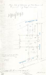
Document - Copy of Lands Department Field Notes - Subdivision of Police Reserve at Ringwood, County of Mornington, Field Notes 1900/293 - Part of O.P. R72C surveyed 1900
Foolscap size photocopy of survey map with handwritten notations. References include Mount Dandenong Road, Dublin Road, Patterson Street, Melbourne to Lilydale railway line, I certify that this is a correct copy of recorded observations made by my assistant (signed) W. Thorn, Staff Surveyor. -
 Ringwood and District Historical Society
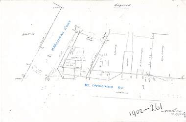
Document - Copy of Lands Department Field Notes - Ringwood, Victoria, Field Notes 1902/261 - Part of O.P. R72D surveyed 14.7.1902
Foolscap size photocopies of survey maps with handwritten notations. -
 Ringwood and District Historical Society
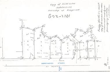
Document - Copy of Lands Department Field Notes - Subdivision Township of Ringwood, Victoria, Field Notes 1902/269 - Part of O.P. R72D surveyed in 1902
Foolscap size photocopy of survey map with handwritten notations. References include Maroondah Highway, (opposite) Mines Road, Ti tree, Sandy soil, heath, spear grass, box & stringy bark sapplings, gentle slope to creek, E. Drury. I certify that this is a correct copy of the recorded observations and measurements made by me personally and my assistant (signed) W. Thorn. -
 Ringwood and District Historical Society
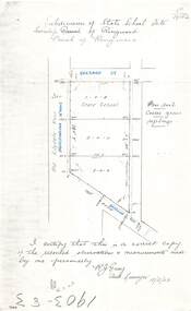
Document - Copy of Lands Department Field Notes - Subdivision of State School Site, Township of Ringwood, Victoria, Field Notes 1903/83 - Part of O.P. R72C Surveyed 13/2/1903
Foolscap size photocopy of survey map with handwritten notations. References include Everard Street, Old Lilydale Road (Maroondah Highway), Dublin Road, poor soil, coarse grass, saplings, I certify that this is a correct copy of the recorded observations & measurements made by me personally (signed) R.J. Gray Autorised Surveyor 13/2/03. -
 Ringwood and District Historical Society
Document - Copy of Lands Department Field Notes - Subdivision of Ringwood, Victoria, Field Notes 1904/188 - Part of O.P. R72D Surveyed 28.4.1904
Foolscap size photocopy of survey map with handwritten notations. References include Mount Dandenong Road to Lilydale, M. Dickson (sold), Church of England, P. Schonnenberger, Helen Lindsay, W.B. iron roof & shingles, I certify that this is a correct copy of the recorded observations and measurement made by me and my assistant (signed) W. Thorn 12/5/04 -
 Ringwood and District Historical Society
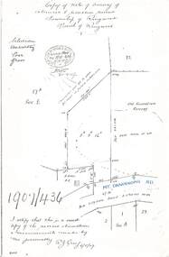
Document - Copy of Lands Department Field Notes - Survey of Extension to Recreation Reserve, Township of Ringwood, Victoria, Field Notes 1907/436 - Part of O.P. R72D Surveyed 6.8.1907
Foolscap size photocopy of survey map with handwritten notations. References include New Lilydale Road 3 chains wide (Mount Dandenong Road), Silurian, undulating, poor grass, Corner cut off to allow for road in future subdivision, Old recreation reserve, (circled area) oval now in use, A. Gisler, I certify that this is a correct copy of the recorded observations & measurements made by me personally (signed) R.J. Gray 6/8/07. -
 Ringwood and District Historical Society
Document - Copy of Lands Department Field Notes - Subdivision Sec E, Township of Ringwood, Victoria, Field Notes 1908/670 - Survey O.P. R72E dated November 1908
Foolscap size photocopies of survey maps with handwritten notations. -
 Ringwood and District Historical Society
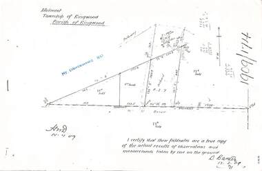
Document - Copy of Lands Department Field Notes - Parish of Ringwood, Victoria, Field Notes 1909/174 - Part of O.P. R72D surveyed 12.3.1909
Foolscap size photocopy of survey map with handwritten notations. References include Mount Dandenong Road, pathway, 2 room house, scillion, shed, WC, 17C sold, Cr lands, orchard, 17E sold, Township boundary, I certify that these field notes are a true copy of the actual results of observations and measurements taken by me on the ground (signed) D. Barker 12.3.09. -
 Ringwood and District Historical Society
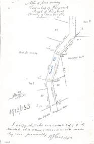
Document - Copy of Lands Department Field Notes - Township of Ringwood, Victoria, Field Notes 1913/163 - Part of O.P. R72D surveyed April 1913
5612b Foolscap size photocopy of survey map with handwritten notations. References include Mines Road, New Lilydale Road (Maroondah Highway), (area) Held for mining, Recreation Reserve, Sec D, Sec E, I certify that this is a correct copy of the recorded observations & measurements made by me personally (signed) R.J. Gray 2/4/13. -
 Ringwood and District Historical Society
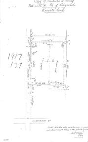
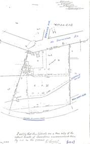
Document - Copy of Lands Department Field Notes - Parish of Ringwood, Victoria, Field Notes 1917/137 - Part of O.P. R72 - Allotment 10, surveyed June 1917
5613b Foolscap size photocopy of survey map with handwritten notations. References include Knight's land, Wantirna Road, Canterbury Road, house, wirenetted, orchard, grass paddock, I certify that these notes are a true copy of observations and measurements taken on the ground by me (signed) H.W. Moore 5/6/17. -
 Ringwood and District Historical Society
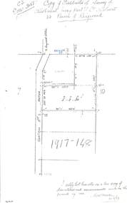
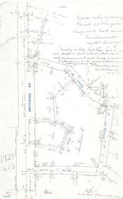
Document - Copy of Lands Department Field Notes - Parish of Ringwood, Victoria, Field Notes 1917/148 - Part of O.P. R72 - Crown Allotment 10, surveyed June 1917
5614b Foolscap size photocopy of survey map with handwritten notations. References include Wantirna Road, to Ringwood Station, Reilly Street, J. Marshall, fence to be erected on boundary, I certify that these notes are a true copy of observations and measurements made on the ground by me (signed) H.W. Moore 22/6/17. -
 Ringwood and District Historical Society
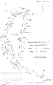
Document - Copy of Lands Department Field Notes - Parish of Ringwood, Victoria, Field Notes - OP34838 - surveyed in 1919 by D. Barker
5615b Foolscap size photocopy of survey map with handwritten notations. References include Braeside Avenue, Mount Dandenong Road, Rosedale Court, Railway Avenue, cyclone fence, Sec A, WB house, old tennis court netted, stable, old shed, tank stand, orchard, Township Boundary, netting fence, Railway fence, Ringwood to Lilydale Railway, I certify that these fieldnotes are a true copy of the actual results of observations & measurements taken by me on the ground (signed) D. Barker (1919). -
 Ringwood and District Historical Society
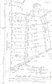
Document - Copy of Lands Department Field Notes - Parish of Ringwood, Victoria, Field Notes - 1928/453 - Part of OP R72C Surveyed on 17.11.1928
5616b Foolscap size photocopy of survey map with handwritten notations. References include Whitehorse Road, Mines Road, Wilson Street, Rupert Street, New Road (Braeside Avenue), Section E, Allot 31 sold, Allot 32 sold, Recreation Reserve, Allot 25 sold, Allot 29 sold, hedge, spikes, links on line from each corner, I hereby certify that these field notes were prepared from actual observations and measurements made by me or under my supervision on the ground and in accord with regulations (signed) Authorised Surveyor 17/11/28. -
 Ringwood and District Historical Society
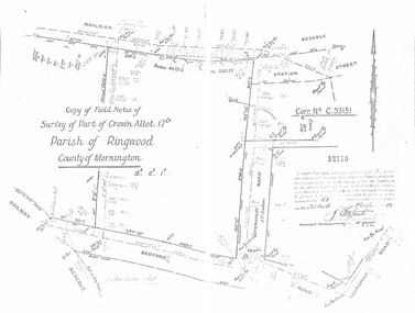
Document - Copy of Lands Department Field Notes - Parish of Ringwood, Victoria, Field Notes - Part of Crown Allotment 17D Surveyed 1952 (Amended in 1953)
5616b Double foolscap size photocopy of survey map with handwritten notations. References include Corr no. C.93151, Railway Reserve, Station Street, Bedford Road, multiple post & wire fences, multiple galv iron pipes put in, Government Road (Hill Street), Tooronga Road, multiple recent pegs found, Certification 52710 by J. Fitzgerald Licensed Surveyor 17/3/1952. -
 Ringwood and District Historical Society
Document - Copy of Lands Department Field Notes - Parish of Ringwood, Victoria, Field Notes 55114 Survey of Allotment by J.D. Sherwood in 1955
5618b Foolscap size photocopy of survey map with handwritten notations. References include Railway (Reserve), Education Department, A-B Datum 117degrees20', Bedford Road, Certification by J.D. Sherwood Licensed Surveyor 23/11/1955. -
 Ringwood and District Historical Society
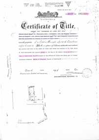
Document - Transfer of Land Act, Certificate of Title Vol 5127 Fol 1025238 including Ringwood Masonic Hall
Photocopied Certificate of Title Vol 5127 Fol 1025238 dated 9th March, 1926. Ernest Albert Milne (orchardist) and Jay Wilkins (builder) of Ringwood and Ernest Hugh Emmanuel Hann (carpenter) of East Ringwood are now proprietors as tenants in common in equal shares, Lot 30 on Plan of Subdivision No. 5577, part of Crown Allotment 19, Parish of Ringwood. Location map includes Aird Street, Pratt Street, Whitehorse Road. Subsequent Proprietors Transfers & Mortgate details include: Herman Pump and Frank Kenworthy of Ringwood and Albert Raymond of Collins Street Melbourne, trustees for the time being of the Loyal Ringwood Lodge No. 6724 of the MUIOOF Victoria Friendly Society - 26 June 1936, Holeproof Limited of 204 Sydney Road Brunswick, proprietor by transfer on 18th February, 1947, (*) Ringwood Masonic Hall Company Limited of 173 Whitehorse Road Ringwood, proprietor by transfer on 14th June, 1950, City Mutual Life Assurance Society Limited registered 1st March, 1965, ANZ Banking Group Limited, registered 10 June, 1981 & Discharged 3 June, 1982, Mayor Councillors and Citizens of the City of Ringwood registered as proprietors 6th July, 1982. (*During WWII, Holeproof had been renting the hall where they manufactured socks.) -
 Ringwood and District Historical Society
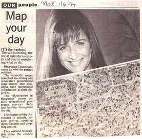
Newspaper, Scrapbook Clipping, Library Collection, Ringwood, Victoria, `
``Newspaper clipping from "The Mail" 1-6-94 OUR people Map your dayThe Ringwood Council's recent launch of an exciting and innovative promotional map means that residents have recreational information at their fingertips. The "Recreation in Ringwood"poster details recreational pograms, services, clubs and facilities throughout the city` -
 Ringwood and District Historical Society
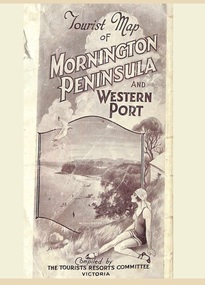
Memorabilia, Tourist Map of Mornington Peninsula and Western Port - 1929
Multi-fold pictorial map of towns, railways and main roads east of Port Phillip Bay from Melbourne to Yarra Junction and south to Phillip Island and Wonthaggi, backed by details of main features and points of interest.Photo-Lithographed by Department of Lands and Survey, Melbourne, 2.8.1929. -
 Ringwood and District Historical Society
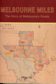
Book, Dr Maxwell Lay, Melbourne Miles - The Story of Melbourne's Roads, 2012
Soft cover book, 300 pages.A comprehensive history of the roads and streets of metropolitan Melbourne, with maps. Dr Max Lay, a Melburnian, is an international authority on roads. His very many publications include the Source Book for Australian Roads, Handbook of Road Technology, History of Australian Roads, Ways of the World, and Encyclopedia Britannica entry on roads. Dr Lay is also the past-president of both the Royal Automobile Club of Victoria and the Australian Automobile Association. -
 Ringwood and District Historical Society
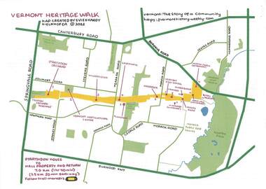
Pamphlet - Map and Guide Notes, Vermont Heritage Walk, Vermont, Victoria - 2022
Double-sided A4 map and 9-page A4 guide notes with QR codes outlining historical and environmental points of interest for participants' walking tour of "Healesville Freeway Reserve" between Springvale Road and Boronia Road, Vermont, Vic - 3.5km, 50 minutes each way. Vermont Heritage Walk map and notes produced by Evie and Hardy Kielnhofer. -
 Ringwood and District Historical Society
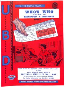
Booklet, UBD Directory of Ringwood & Districts 1961-62
A Universal Business Directories Publication. Contains: Numerous advertisements by local business Summary of Ringwood services groups, wards, parks, schools, councillors, etc Doctor's Surgeries Index of streets Aerial maps Lists of businesses by business categories Includes the same for Croydon, Lilydale, Heathmont and Kilsyth. Some small business lists for Warrandyte, South Warrandyte, Vermont and Montrose. -
 Ringwood and District Historical Society
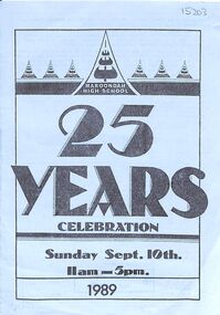
Pamphlet, 8-page on 25-year celebration of Maroondah High School (formerly Croydon West HS), now Melba College
Celebrated in 1989 on Sunday 10th September.John Hutchinson, Chairman of 25th Birthday Committee. A Douglas, first principal, F Russell, second, and H Fletcher, third. Contains map of celebrations and school song. -
 Ringwood and District Historical Society
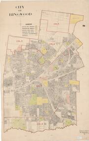
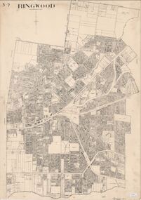
Map, City of Ringwood - Rateable Properties Layout - c.1966. Overlay showing Reserves, Open Space, Playgrounds, and Schools
A0-size (approx) map of named streets, lot-numbered properties and locality features within City of Ringwood boundary. Colour-coded legend identifying Existing Rec Reserves, Proposed Rec Reserves, Existing Open Space, Children's Playgrounds, and Schools.Scale: 8 chains to 1 inch. Map picked up in Engineer's office at old town hall prior to demolition 1971. -
 Ringwood and District Historical Society
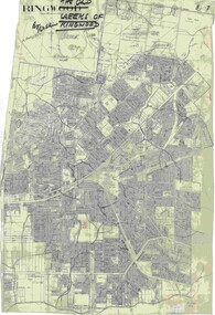
Map, City of Ringwood - Rateable Properties Layout - c.1966
A0-size (approx) map of named streets, lot-numbered properties and locality features within City of Ringwood boundary. Scale: 8 chains to 1 inch. City Engineer's signature in bottom right corner - Alan Robertson (City Engineer 1958-1987) -
 Ringwood and District Historical Society
Map, Old Creeks of Ringwood
A0-size (approx) City Engineer's map with hand-drawn overlay highlighting natural water-courses in the Ringwood area, as identified by Rob Atkins, former RDHS President. Other pencilled markings include Perry's Hut, Jull's Store, Crawley's Hut.Scale: 8 chains to 1 inch. -
 Ringwood and District Historical Society
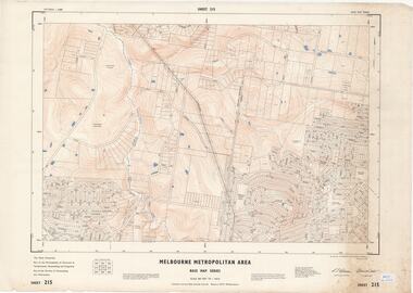
Map - Melbourne Metropolitan Area Base Map Series, Sheet 215 - Ringwood area, 1967
Map prepared by Dept of Lands and Survey and MMBW from State Aerial Survey June 1957 and Cadastral Survey information July 1967. This sheet comprises parts of Municipalities of Doncaster & Templestowe, Nunawading and Ringwood, and Parishes of Nunawading and Warrandyte.Scale: 400 feet to 1 inch. Contours at 5 feet vertical interval. By Authority: A.C. Brooks, Commonwealth Printer, Melbourne. -
 Ringwood and District Historical Society
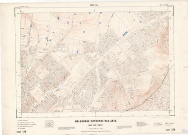
Map - Melbourne Metropolitan Area Base Map Series, Sheet 216 - Ringwood area, 1967
Map prepared by Dept of Lands and Survey and MMBW from State Aerial Survey June 1957 and Cadastral Survey information July 1967. This sheet comprises parts of Municipalities of Croydon, Doncaster & Templestowe, and Ringwood, and Parishes of Ringwood and Warrandyte.Scale: 400 feet to 1 inch. Contours at 5 feet vertical interval. By Authority: A.C. Brooks, Commonwealth Printer, Melbourne. -
 Ringwood and District Historical Society
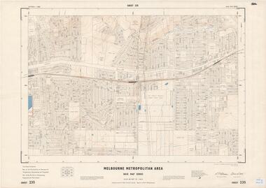
Map - Melbourne Metropolitan Area Base Map Series, Sheet 235 - Ringwood area, 1960
Map prepared by Dept of Lands and Survey and MMBW from State Aerial Survey June 1957 and Cadastral Survey information August 1960. This sheet comprises parts of Municipalities of Doncaster & Templestowe, Nunawading and Ringwood, and Parishes of Nunawading, Ringwood and Warrandyte.Scale: 400 feet to 1 inch. Contours at 5 feet vertical interval. By Authority: A.C. Brooks, Commonwealth Printer, Melbourne.