Showing 113958 items matching "road-making"
-
 Ringwood and District Historical Society
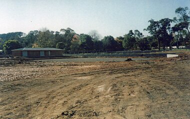
Photograph, Ringwood Bowls Club- Construction of new Bowls Club at corner of Laughnan Road and Warrandyte Road, 1996
Coloured photographPhotograph shows earthworks for greens at new Bowls Club at Laughnan Road. -
 Ringwood and District Historical Society
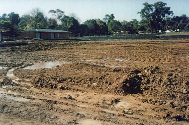
Photograph, Ringwood Bowls Club- Construction of new Bowls Club at corner of Laughnan Road and Warrandyte Road, 1996
Coloured photographPhotograph shows earthworks for greens at new Bowls Club at Laughnan Road. -
 Ringwood and District Historical Society
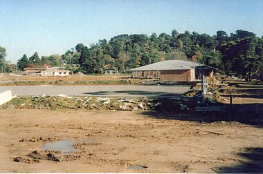
Photograph, Ringwood Bowls Club- Construction of new Bowls Club at corner of Laughnan Road and Warrandyte Road, 1996
Coloured photographPhotograph shows earthworks for greens at new Bowls Club at Laughnan Road. -
 Ringwood and District Historical Society
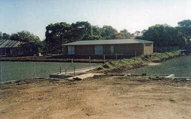
Photograph, Ringwood Bowls Club- Construction of new Bowls Club at corner of Laughnan Road and Warrandyte Road, 1996
Coloured photographPhotograph shows earthworks for greens at new Bowls Club at Laughnan Road. -
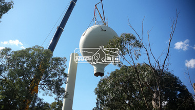 Eltham District Historical Society Inc
Photograph, Demolition of water tower at 51 Cassells Road, Research, 6 April 2017, 6/4/2017
"The water storage tank (the ‘golf ball’ tower) was located in Cassells Road, and for many years it played an important role in supplying the Research and Eltham communities with drinking water. However, due to prior upgrades of water supply infrastructure in the area, these communities are receiving their water supply in a more reliable way. The storage tank was no longer operating and as it no longer served a purpose, the time had come for it to be removed. Decommissioning works occurred between November 2016 and January 2017, and the tower was removed in March 2017." Source: Yarra Valley Water Eltham Water Project onlineDigital files only (17 jpg and one two second MP4 files)cassells road, demolition, research (vic.), water tower -
 Glen Eira Historical Society
Album - Album page, St Stephen's Presbyterian Church, Balaclava Road, Circa 1972
This photograph is part of the Caulfield Historical Album 1972. This album was created in approximately 1972 as part of a project by the Caulfield Historical Society to assist in identifying buildings worthy of preservation. The album is related to a Survey the Caulfield Historical Society developed in collaboration with the National Trust of Australia (Victoria) and Caulfield City Council to identify historic buildings within the City of Caulfield that warranted the protection of a National Trust Classification. Principal photographer thought to be Trevor Hart, member of Caulfield Historical Society. Most photographs were taken between 1966-1972 with a small number of photographs being older and from unknown sources. All photographs are black and white except where stated, with 386 photographs over 198 pages. From: Glen Eira Heritage Management Plan (1996) by Andrew Ward and Associates In 1905, the land was vacant in Balaclava Road, north side, from Kooyong Road east to the right of way, except for one house. A block of this land was acquired by the Presbyterian community and a timber church erected there in 1910. In time, a larger church was required. After several years of fund raising led by George Kinross, a new red brick St Stephen's church was built in 1926 to the design of architects Haddon and Henderson. George Currie was the builder and the cost of construction was £5,100.From: Glen Eira Heritage Management Plan (1996) by Andrew Ward and Associates: St Stephens has architectural importance as a noteworthy example of a Gothic Transitional design in the Arts and Crafts eclectic manner (see Stylistic Typology in National Trust's Historic Church's Study}. The facade treatment successfully combines Christian symbols with Gothic forms in the Arts and Crafts mode (comparable with Haddon's Presbyterian Church, Malvern (1906) and Haddon and Henderson's Oakleigh Church (1928). It is locally important as an example of Robert Haddon's work in Caulfield, where he also lived (4 Glenferrie St q.v.).Page 25 of Photograph Album - four black and white photographs of St Stephen's Presbyterian Church, with two photographs in landscape mode across the top showing information about who designed the building in one and showing the church name and year founded in the other; and two in portrait mode in the bottom section showing 2 different heavy wooden doors.Hand written: 25 [bottom left]trevor hart, caulfield north, balaclava road, george kinross, haddon and henderson, george currie, st stephen's, 1900's, 1920's, gothic transitional, christian symbols, arts and crafts, robert haddon, stylistic typology, gothic, presbyterian church, architects, red brick, doors, memorials -
 Glen Eira Historical Society
Album - Album page, St Stephen's Presbyterian Church, Balaclava Road, Circa 1972
This photograph is part of the Caulfield Historical Album 1972. This album was created in approximately 1972 as part of a project by the Caulfield Historical Society to assist in identifying buildings worthy of preservation. The album is related to a Survey the Caulfield Historical Society developed in collaboration with the National Trust of Australia (Victoria) and Caulfield City Council to identify historic buildings within the City of Caulfield that warranted the protection of a National Trust Classification. Principal photographer thought to be Trevor Hart, member of Caulfield Historical Society. Most photographs were taken between 1966-1972 with a small number of photographs being older and from unknown sources. All photographs are black and white except where stated, with 386 photographs over 198 pages. From: Glen Eira Heritage Management Plan (1996) by Andrew Ward and Associates In 1905, the land was vacant in Balaclava Road, north side, from Kooyong Road east to the right of way, except for one house. A block of this land was acquired by the Presbyterian community and a timber church erected there in 1910. In time, a larger church was required. After several years of fund raising led by George Kinross, a new red brick St Stephen's church was built in 1926 to the design of architects Haddon and Henderson. George Currie was the builder and the cost of construction was £5,100.From: Glen Eira Heritage Management Plan (1996) by Andrew Ward and Associates: St Stephens has architectural importance as a noteworthy example of a Gothic Transitional design in the Arts and Crafts eclectic manner (see Stylistic Typology in National Trust's Historic Church's Study}. The facade treatment successfully combines Christian symbols with Gothic forms in the Arts and Crafts mode (comparable with Haddon's Presbyterian Church, Malvern (1906) and Haddon and Henderson's Oakleigh Church (1928). It is locally important as an example of Robert Haddon's work in Caulfield, where he also lived (4 Glenferrie St q.v.).Page 27 of Photograph Album with one photograph of a drawing or perhaps a postcard of St Stephen's Presbyterian Church. It has a large block of formal writing in the bottom right corner which looks official.Hand written: 27 [bottom right]trevor hart, caulfield north, balaclava road, george kinross, haddon and henderson, george currie, st stephen's, 1900's, 1920's, gothic transitional, christian symbols, arts and crafts, robert haddon, stylistic typology, gothic, presbyterian church, architects, drawings -
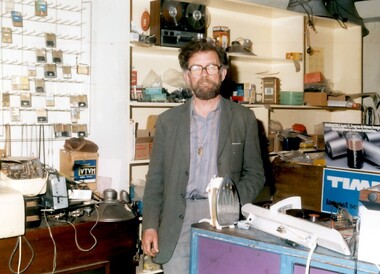 Surrey Hills Historical Society Collection
Photo, Henry Jamieson in his shop at 149 Union Road, Surrey Hills
Henry was a familiar persona in Union Road and around the Surrey Hills Neighbourhood Centre for decades. He lived all his life within 3 kilometres of his radio shop. Son of Catherine and ‘Mick’ Jamieson, Henry was born in 1927 in View Street, Surrey Hills and was educated at Box Hill Grammar School. His father died when he was young and Henry took a job as a technical assistant with the Commonwealth Film Unit. Film was a life-long interest and he became a longstanding member of CATHS (Cinema and Theatre Historical Society of Victoria). Henry also had a profound love of music which was reflected in his work and hobbies. He joined Adrian Knowles, who had started his radio shop at 149 Union Road in the 1940s, and trained at RMIT as a radio tradesman. In time Henry took over the business. When 3MBS established in Kew, Henry was an enthusiastic supporter and volunteer. For some years Henry and a co-producer presented a prime time Saturday evening programme 'Bach to Bernstein'; later his distinctive voice could be heard in the early morning time slot, 'Daybreak'. Henry was also a staunch supporter of the Surrey Hills Historical Society and served as its President for a number of years. Henry died in 2011. Colour photo of a bearded man inside a shop with an assortment of radio and electrical appliances and components.knowles radio, surrey hills neighbourhood centre, union road, surrey hills historical society, cinema and theatre historical society of victoria, 3mbs radio, henry jamieson, adrain knowles -
 Eltham District Historical Society Inc
Photograph, Main Road, Panton Hill
Two colour photographs of Main Road Panton Hill showing roundabout at Church Road/Roger Road intersectionmain road, st andrews road, kangaroo ground/st andrews road, church road, roger road, roundabouts, panton hill -
 Whitehorse Historical Society Inc.
Map, Deep Creek Road, Mitcham, c1975
Enlargement of aerial photograph of area bounded by Dalmar Road, Cray Road, Glenvale Road and Maroondah Highway, MitchamEnlargement of aerial photograph of area bounded by Dalmar Road, Cray Road, Glenvale Road and Maroondah Highway, MitchamEnlargement of aerial photograph of area bounded by Dalmar Road, Cray Road, Glenvale Road and Maroondah Highway, Mitchamcray road, donvale, glenvale road, donvale, maroondah highway, mitcham, dalmor road, mitcham, deep creek road, mitcham, aerial photographs -
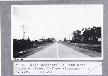 Whitehorse Historical Society Inc.
Photograph, Main Healesville Road, 5-9.1938
Whitehorse Road ( known as Main Healesville Road) near Goodwin Street, Blackburn in 1938. A two lane road.whitehorse road, main healesville road, goodwin street blackburn, blackburn -
Lakes Entrance Historical Society
Book, Road Design Manual, 1985
Road design manual for rural and urban roads other than freeways giving all aspects of road construction.road construction and maintenance -
 Eltham District Historical Society Inc
Photograph, Former Eltham Police Residence, 728 Main Road, Eltham, c.1985, 1985c
This photo is believed to have been taken circa 1985 when the Shire of Eltham Parks and Environment occupied the site. This photo was originally mounted on 3mm MDF fibre board with notes and stickers applied as part of a display on the former Police Residence and now present day Local History Centre, home to Eltham District Historical Society; possibly put together by Harry Gilham during his time as president of the society. Eltham Police Station and Residence: A brief history 1860 Eltham Courthouse built in Main Road, together with an adjoining police residence, office, lock–up and stables. 1959 Police Department purchases a house in Pryor Street to be refurbished as Eltham Police Station 1961 Police in Eltham move into Pryor Street refurbished buildings and office. c.1961-1981 Occupied by Vermin and Noxious Weeds Destruction Section of the Department of Crown Lands and Survey. Former Police Station dragged around to rear of Police Residence (prior to August 1967) to make way for the construction of a driveway and access from Main Road. The building was placed on the site of a former Scullery and modified for Lands Department use. 1981 Shire of Eltham take over management of old Police Residence in Eltham. It remains unoccupied for a period of time whilst its future is discussed in Council. 1981-1985 Used for community job creation scheme 1985 Shire of Eltham Parks and Environment occupy the residence. Council improve the driveway but later add a second rear access from Brougham Street due to the dangerous nature of the Main Road entrance. Also add a rear toilet facility between the Police Residence and former Police Station, which was doubling up as a lunch room. Council also commence discussions to re-establish a replica Police Station. c.1986 November. Former Police Station demolished; believed to have been suffering termite damage. c.1989 After some years of discussion a replica Police Station is built, based on photographs, to act as a lunch room and meeting room for Parks and Environment staff and volunteers doing community service. 1996 Eltham District Historical Society in discussions with Nillumbik Shire Council commisioners throughout the year regarding a home for the Society. A proposal put forward by the Society in October to occupy the former Police Residence. 1997 March. Eltham District Historical Society gains access to former Police Residence. 1998 July 12th. Eltham District Historical Society Inc moves into its Local History Centre, 728 Main Road Eltham (the former Police Residnce built in 1860). 2018 July. Eltham District Historical Society gains access to the replica Police Station for use as part of regular heritage tours for schools and community based groups.Colour printHandwritten in faded blue felt pen ink "No. 3 - Front of 728 Police Residence. 1860 Court House over the paling fence. Verandah missing from earlier photographs"728 main road, eltham, local history centre, parks and environment, police residence, police station, shire of eltham -
 Eltham District Historical Society Inc
Photograph, Former Eltham Police Residence, 728 Main Road, Eltham, c.1985, 1985c
This photo is believed to have been taken circa 1985 when the Shire of Eltham Parks and Environment occupied the site. This photo was originally mounted on 3mm MDF fibre board with notes and stickers applied as part of a display on the former Police Residence and now present day Local History Centre, home to Eltham District Historical Society; possibly put together by Harry Gilham during his time as president of the society. Eltham Police Station and Residence: A brief history 1860 Eltham Courthouse built in Main Road, together with an adjoining police residence, office, lock–up and stables. 1959 Police Department purchases a house in Pryor Street to be refurbished as Eltham Police Station 1961 Police in Eltham move into Pryor Street refurbished buildings and office. c.1961-1981 Occupied by Vermin and Noxious Weeds Destruction Section of the Department of Crown Lands and Survey. Former Police Station dragged around to rear of Police Residence (prior to August 1967) to make way for the construction of a driveway and access from Main Road. The building was placed on the site of a former Scullery and modified for Lands Department use. 1981 Shire of Eltham take over management of old Police Residence in Eltham. It remains unoccupied for a period of time whilst its future is discussed in Council. 1981-1985 Used for community job creation scheme 1985 Shire of Eltham Parks and Environment occupy the residence. Council improve the driveway but later add a second rear access from Brougham Street due to the dangerous nature of the Main Road entrance. Also add a rear toilet facility between the Police Residence and former Police Station, which was doubling up as a lunch room. Council also commence discussions to re-establish a replica Police Station. c.1986 November. Former Police Station demolished; believed to have been suffering termite damage. c.1989 After some years of discussion a replica Police Station is built, based on photographs, to act as a lunch room and meeting room for Parks and Environment staff and volunteers doing community service. 1996 Eltham District Historical Society in discussions with Nillumbik Shire Council commisioners throughout the year regarding a home for the Society. A proposal put forward by the Society in October to occupy the former Police Residence. 1997 March. Eltham District Historical Society gains access to former Police Residence. 1998 July 12th. Eltham District Historical Society Inc moves into its Local History Centre, 728 Main Road Eltham (the former Police Residnce built in 1860). 2018 July. Eltham District Historical Society gains access to the replica Police Station for use as part of regular heritage tours for schools and community based groups.Colour printHandwritten in faded blue felt pen ink "No. 2 - Backyard of 728 #5 Weatherboard 'Office'. Note 1860 Court House over the fence."728 main road, eltham, local history centre, parks and environment, police residence, police station, shire of eltham -
 Eltham District Historical Society Inc
Photograph, Former Eltham Police Residence, 728 Main Road, Eltham, c.1985, 1985c
This photo is believed to have been taken circa 1985 when the Shire of Eltham Parks and Environment occupied the site. This photo was originally mounted on 3mm MDF fibre board with notes and stickers applied as part of a display on the former Police Residence and now present day Local History Centre, home to Eltham District Historical Society; possibly put together by Harry Gilham during his time as president of the society. Eltham Police Station and Residence: A brief history 1860 Eltham Courthouse built in Main Road, together with an adjoining police residence, office, lock–up and stables. 1959 Police Department purchases a house in Pryor Street to be refurbished as Eltham Police Station 1961 Police in Eltham move into Pryor Street refurbished buildings and office. c.1961-1981 Occupied by Vermin and Noxious Weeds Destruction Section of the Department of Crown Lands and Survey. Former Police Station dragged around to rear of Police Residence (prior to August 1967) to make way for the construction of a driveway and access from Main Road. The building was placed on the site of a former Scullery and modified for Lands Department use. 1981 Shire of Eltham take over management of old Police Residence in Eltham. It remains unoccupied for a period of time whilst its future is discussed in Council. 1981-1985 Used for community job creation scheme 1985 Shire of Eltham Parks and Environment occupy the residence. Council improve the driveway but later add a second rear access from Brougham Street due to the dangerous nature of the Main Road entrance. Also add a rear toilet facility between the Police Residence and former Police Station, which was doubling up as a lunch room. Council also commence discussions to re-establish a replica Police Station. c.1986 November. Former Police Station demolished; believed to have been suffering termite damage. c.1989 After some years of discussion a replica Police Station is built, based on photographs, to act as a lunch room and meeting room for Parks and Environment staff and volunteers doing community service. 1996 Eltham District Historical Society in discussions with Nillumbik Shire Council commisioners throughout the year regarding a home for the Society. A proposal put forward by the Society in October to occupy the former Police Residence. 1997 March. Eltham District Historical Society gains access to former Police Residence. 1998 July 12th. Eltham District Historical Society Inc moves into its Local History Centre, 728 Main Road Eltham (the former Police Residnce built in 1860). 2018 July. Eltham District Historical Society gains access to the replica Police Station for use as part of regular heritage tours for schools and community based groups.Colour printHandwritten in faded blue felt pen ink "Roof of room 5 (weatherboard office) and W.C. See No. 2 for another view"728 main road, eltham, local history centre, parks and environment, police residence, police station, shire of eltham -
 Eltham District Historical Society Inc
Photograph, Former Eltham Police Residence, 728 Main Road, Eltham, c.1985, 1985c
This photo is believed to have been taken circa 1985 when the Shire of Eltham Parks and Environment occupied the site. This photo was originally mounted on 3mm MDF fibre board with notes and stickers applied as part of a display on the former Police Residence and now present day Local History Centre, home to Eltham District Historical Society; possibly put together by Harry Gilham during his time as president of the society. Eltham Police Station and Residence: A brief history 1860 Eltham Courthouse built in Main Road, together with an adjoining police residence, office, lock–up and stables. 1959 Police Department purchases a house in Pryor Street to be refurbished as Eltham Police Station 1961 Police in Eltham move into Pryor Street refurbished buildings and office. c.1961-1981 Occupied by Vermin and Noxious Weeds Destruction Section of the Department of Crown Lands and Survey. Former Police Station dragged around to rear of Police Residence (prior to August 1967) to make way for the construction of a driveway and access from Main Road. The building was placed on the site of a former Scullery and modified for Lands Department use. 1981 Shire of Eltham take over management of old Police Residence in Eltham. It remains unoccupied for a period of time whilst its future is discussed in Council. 1981-1985 Used for community job creation scheme 1985 Shire of Eltham Parks and Environment occupy the residence. Council improve the driveway but later add a second rear access from Brougham Street due to the dangerous nature of the Main Road entrance. Also add a rear toilet facility between the Police Residence and former Police Station, which was doubling up as a lunch room. Council also commence discussions to re-establish a replica Police Station. c.1986 November. Former Police Station demolished; believed to have been suffering termite damage. c.1989 After some years of discussion a replica Police Station is built, based on photographs, to act as a lunch room and meeting room for Parks and Environment staff and volunteers doing community service. 1996 Eltham District Historical Society in discussions with Nillumbik Shire Council commisioners throughout the year regarding a home for the Society. A proposal put forward by the Society in October to occupy the former Police Residence. 1997 March. Eltham District Historical Society gains access to former Police Residence. 1998 July 12th. Eltham District Historical Society Inc moves into its Local History Centre, 728 Main Road Eltham (the former Police Residnce built in 1860). 2018 July. Eltham District Historical Society gains access to the replica Police Station for use as part of regular heritage tours for schools and community based groups.Colour printHandwritten in faded blue felt pen ink "Another view of north wall 728 No. 4. Taken from west end towards back yard"728 main road, eltham, local history centre, parks and environment, police residence, police station, shire of eltham -
 Eltham District Historical Society Inc
Photograph, Former Eltham Police Residence, 728 Main Road, Eltham, c.1985, 1985c
This photo is believed to have been taken circa 1985 when the Shire of Eltham Parks and Environment occupied the site. This photo was originally mounted on 3mm MDF fibre board with notes and stickers applied as part of a display on the former Police Residence and now present day Local History Centre, home to Eltham District Historical Society; possibly put together by Harry Gilham during his time as president of the society. Eltham Police Station and Residence: A brief history 1860 Eltham Courthouse built in Main Road, together with an adjoining police residence, office, lock–up and stables. 1959 Police Department purchases a house in Pryor Street to be refurbished as Eltham Police Station 1961 Police in Eltham move into Pryor Street refurbished buildings and office. c.1961-1981 Occupied by Vermin and Noxious Weeds Destruction Section of the Department of Crown Lands and Survey. Former Police Station dragged around to rear of Police Residence (prior to August 1967) to make way for the construction of a driveway and access from Main Road. The building was placed on the site of a former Scullery and modified for Lands Department use. 1981 Shire of Eltham take over management of old Police Residence in Eltham. It remains unoccupied for a period of time whilst its future is discussed in Council. 1981-1985 Used for community job creation scheme 1985 Shire of Eltham Parks and Environment occupy the residence. Council improve the driveway but later add a second rear access from Brougham Street due to the dangerous nature of the Main Road entrance. Also add a rear toilet facility between the Police Residence and former Police Station, which was doubling up as a lunch room. Council also commence discussions to re-establish a replica Police Station. c.1986 November. Former Police Station demolished; believed to have been suffering termite damage. c.1989 After some years of discussion a replica Police Station is built, based on photographs, to act as a lunch room and meeting room for Parks and Environment staff and volunteers doing community service. 1996 Eltham District Historical Society in discussions with Nillumbik Shire Council commisioners throughout the year regarding a home for the Society. A proposal put forward by the Society in October to occupy the former Police Residence. 1997 March. Eltham District Historical Society gains access to former Police Residence. 1998 July 12th. Eltham District Historical Society Inc moves into its Local History Centre, 728 Main Road Eltham (the former Police Residnce built in 1860). 2018 July. Eltham District Historical Society gains access to the replica Police Station for use as part of regular heritage tours for schools and community based groups.Colour printHandwritten in faded blue felt pen ink "Repeat view of No. 4 from external corner of weatherboard extn. Room 5"728 main road, eltham, local history centre, parks and environment, police residence, police station, shire of eltham -
 Eltham District Historical Society Inc
Photograph, Former Eltham Police Residence, 728 Main Road, Eltham, c.1985, 1985c
This photo is believed to have been taken circa 1985 when the Shire of Eltham Parks and Environment occupied the site. This photo was originally mounted on 3mm MDF fibre board with notes and stickers applied as part of a display on the former Police Residence and now present day Local History Centre, home to Eltham District Historical Society; possibly put together by Harry Gilham during his time as president of the society. Eltham Police Station and Residence: A brief history 1860 Eltham Courthouse built in Main Road, together with an adjoining police residence, office, lock–up and stables. 1959 Police Department purchases a house in Pryor Street to be refurbished as Eltham Police Station 1961 Police in Eltham move into Pryor Street refurbished buildings and office. c.1961-1981 Occupied by Vermin and Noxious Weeds Destruction Section of the Department of Crown Lands and Survey. Former Police Station dragged around to rear of Police Residence (prior to August 1967) to make way for the construction of a driveway and access from Main Road. The building was placed on the site of a former Scullery and modified for Lands Department use. 1981 Shire of Eltham take over management of old Police Residence in Eltham. It remains unoccupied for a period of time whilst its future is discussed in Council. 1981-1985 Used for community job creation scheme 1985 Shire of Eltham Parks and Environment occupy the residence. Council improve the driveway but later add a second rear access from Brougham Street due to the dangerous nature of the Main Road entrance. Also add a rear toilet facility between the Police Residence and former Police Station, which was doubling up as a lunch room. Council also commence discussions to re-establish a replica Police Station. c.1986 November. Former Police Station demolished; believed to have been suffering termite damage. c.1989 After some years of discussion a replica Police Station is built, based on photographs, to act as a lunch room and meeting room for Parks and Environment staff and volunteers doing community service. 1996 Eltham District Historical Society in discussions with Nillumbik Shire Council commisioners throughout the year regarding a home for the Society. A proposal put forward by the Society in October to occupy the former Police Residence. 1997 March. Eltham District Historical Society gains access to former Police Residence. 1998 July 12th. Eltham District Historical Society Inc moves into its Local History Centre, 728 Main Road Eltham (the former Police Residnce built in 1860). 2018 July. Eltham District Historical Society gains access to the replica Police Station for use as part of regular heritage tours for schools and community based groups.Colour printHandwritten in faded blue felt pen ink "Backdoor to residence. White paint still visible 2010 on brickwork"728 main road, eltham, local history centre, parks and environment, police residence, police station, shire of eltham -
 Eltham District Historical Society Inc
Photograph, Former Eltham Police Residence, 728 Main Road, Eltham, c.1985, 1985c
This photo is believed to have been taken circa 1985 when the Shire of Eltham Parks and Environment occupied the site. This photo was originally mounted on 3mm MDF fibre board with notes and stickers applied as part of a display on the former Police Residence and now present day Local History Centre, home to Eltham District Historical Society; possibly put together by Harry Gilham during his time as president of the society. Eltham Police Station and Residence: A brief history 1860 Eltham Courthouse built in Main Road, together with an adjoining police residence, office, lock–up and stables. 1959 Police Department purchases a house in Pryor Street to be refurbished as Eltham Police Station 1961 Police in Eltham move into Pryor Street refurbished buildings and office. c.1961-1981 Occupied by Vermin and Noxious Weeds Destruction Section of the Department of Crown Lands and Survey. Former Police Station dragged around to rear of Police Residence (prior to August 1967) to make way for the construction of a driveway and access from Main Road. The building was placed on the site of a former Scullery and modified for Lands Department use. 1981 Shire of Eltham take over management of old Police Residence in Eltham. It remains unoccupied for a period of time whilst its future is discussed in Council. 1981-1985 Used for community job creation scheme 1985 Shire of Eltham Parks and Environment occupy the residence. Council improve the driveway but later add a second rear access from Brougham Street due to the dangerous nature of the Main Road entrance. Also add a rear toilet facility between the Police Residence and former Police Station, which was doubling up as a lunch room. Council also commence discussions to re-establish a replica Police Station. c.1986 November. Former Police Station demolished; believed to have been suffering termite damage. c.1989 After some years of discussion a replica Police Station is built, based on photographs, to act as a lunch room and meeting room for Parks and Environment staff and volunteers doing community service. 1996 Eltham District Historical Society in discussions with Nillumbik Shire Council commisioners throughout the year regarding a home for the Society. A proposal put forward by the Society in October to occupy the former Police Residence. 1997 March. Eltham District Historical Society gains access to former Police Residence. 1998 July 12th. Eltham District Historical Society Inc moves into its Local History Centre, 728 Main Road Eltham (the former Police Residnce built in 1860). 2018 July. Eltham District Historical Society gains access to the replica Police Station for use as part of regular heritage tours for schools and community based groups.Colour printHandwritten in faded blue felt pen ink "No. 1 South wall of 728 & back of house built 1860 [1859]. Demolition of weatherboard extension into yard area"728 main road, eltham, local history centre, parks and environment, police residence, police station, shire of eltham -
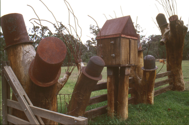 Nillumbik Shire Council
Sculpture: Tony Trembath (b.1946 Sale, Victoria), Tony Trembath, The Fences Act 1968 - Location: Edendale Farm (entrance) 30 Gastons Road, Eltham, 1989 - 1994
Eltham Council (now the Shire of Nillumbik) commissioned this work in 1989 to create an entrance / gateway to Edendale Community Farm. It was also aided by a grant from the Ministry of the Arts (now Arts Victoria). The former name of this work was "Gateway to Edendale Farm". Edendale Farm is a demonstration farm modelling sustainable environmental practices, providing support to the local residents of Nillumbik. Established in 1986, the land was purchased in 1970. It was previously an English gentleman's residence and was used for grazing. It consists of 5.6 hectares, with the Diamond Creek meandering through the property. The Victorian Fences Act 1968 governs liability of occupiers of adjoining lands to fence, and deals with disputes between neighbours regarding boundaries fences and costs. This work took into consideration ideas and suggestions from residents and committees, who required the use of recycled materials and that the work celebrate man's relationship with nature, animals and the earth, as well as relate to the fence-line on the far side of the carpark. Trembath also absorbed significant aspects of local history, making references to Eltham's agricultural past, the clearing of the land, the destruction of trees, the ruthless pruning of trees by suburban Councils and incorporated such Australian features as the post and rail fence. 'The Fences Act 1968' is significant for aesthetic, historic and social reasons at a regional level. It makes prominent the historical and social significance of Edendale and the rural aspects of Nillumbik. The use of existing tree stumps and salt pots in the work explores the iconography of the countryside such as the isolated farmhouse, pioneering farming practices, post and rail fencing and the regrowth of lopped trees. The title of the work, as well as the extensive community involvement in its creation, also makes reference to the Victorian Fences Act 1968, which makes neighbours jointly responsible for the cost of construction and maintenance of fences in the partitioning of land for settlement. 'The Fences Act 1968' has been classified as of regional significance by the National Trust of Australia. The work is an installation of wood and metal, approximately twenty five meters long. The design is very informal and rustic and runs the full width of the fence-line. It comprises groups of recycled tree trunks fitted with metal caps (chrome-nickel 'salt pots' that are shaped like tall bowler / top hats). Metal rods protrude from the trunks and some of these rods have metal birds. Two larger, sentinel-like stumps at the two outer ends have metal flame-like wings, which bend inward. To the left of the entrance, a simple architectural element indicates an isolated farmhouse. The rustic fence runs between the groups of tree trunks with native planting in clumps along it. The fence-line incorporates a functional engineered double gate and post and rail fencing. There may be many interpretations of the work and the intention is to stimulate interest and imagination rather than alienate. Interpretation is based on the personal experience that a visitor brings. The artist recommended that no explanation of the design logic be positioned with the work. N/Apublic art, sculpture, edendale, recycled, wood, metal, fences act 1968, gate, trembath, salt pot, tree stumps -
Whitehorse Historical Society Inc.
Map, Springvale Road, 1987
Aerial photograph of cnr Springvale Road and Burwood Highway, south past Highbury Road and west past Blackburn Road.Aerial photograph of cnr Springvale Road and Burwood Highway, south past Highbury Road and west past Blackburn Road.Aerial photograph of cnr Springvale Road and Burwood Highway, south past Highbury Road and west past Blackburn Road.aerial photographs, blackburn road, burwood east, highbury road, burwood east, burwood highway, burwood east, springvale road, burwood east, burwood east -
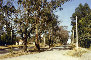 Whitehorse Historical Society Inc.
Photograph, Canterbury Road, Vermont, 1967
Part of Tim Shambrook's Collection for 'This is Vermont'. Not used.Coloured photo of Canterbury Road, Vermont, taken in 1967 showing one lane road and heavily treed side road.canterbury road, vermont, shambrook, tim -
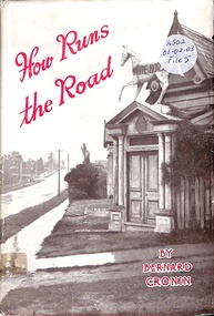 Ringwood and District Historical Society
Book, How Runs the Road
Romance and appeal of roads and a look at the future of Australian roads and transport -
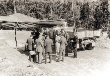 Eltham District Historical Society Inc
Photograph, Country Road Board members having morning tea just south of St Andrews, Heidelberg-Kinglake Road, 1962, 1962
Black and white photograph of Council and Country Road Board group with truckheidelberg kinglake road, kinglake road -
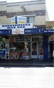 Glen Eira Historical Society
Photograph, Murrumbeena Road, 229, Murrumbeena, 2001
Originally labelled "Beauville Estate, Established 1936, Still Thriving 65 years on, 10th March 2001", the Beauville Estate Album contains colour photographs of houses in the Estate. They were taken around the time of the Beauville Estate’s 65th Heritage Celebration held on 10/03/2001 and donated to the Caulfield Historical Society shortly afterwards. Photographer unknown. From Glen Eira’s Heritage Management Plan by Andrew Ward (1996) Vol 2 p78: In Murrumbeena Road, the shops which form part of the estate are a simple cream brick row relieved by manganese bricks in bands across the upper storeys. City of Glen Eira’s Heritage Management Plan Vol 2 p79 (this is p84 of the pdf version) – HO12 Beauville Estate and environs, Murrumbeena: The Beauville Historic Area is important at the State level as the first large housing estate undertaken by the AV Jennings Construction Co, later Jennings Group Limited, Victoria’s largest home builder. It is important also as a very early estate development incorporating a range of features other than houses and including made roads, shops and recreation facilities. In this respect it was the forerunner of the comprehensively planned housing estate of the post war era. The estate is distinguished by its aesthetic values, as is the earlier and comparable Hillcrest Estate, which are formed by a combination of restrained diversity in house styles, with the exception of no. 30 in the emerging International style, and by a landscaped garden environment. Colour photograph of a section of a double storey, unpainted brick, commercial property containing shops at ground level all with awnings over the footpath. This specific property is a milk bar on street level with plate glass windows and door, colourful advertising and "229' in the top right section of the window. Shop signage says "MURREMBEENA MILK BAR". The upper storey brick residence features a large window, a flat roof and decorative two tone banded brickwork. MURREMBEENA (sic) MILK BAR / PK's / SANDWICH / BAR / MILK BAR & Sandwich Bar / 229 / SUB NEWSmurrumbeena, architectural styles, 1930's, inter war style, a.v. jennings, av jennings, jennings, beauville estate, murrumbeena road, milk bars, commercial establishments, flats, sir albert victor jennings, a v jennings construction co, beauville estate heritage area, glen eira city council, architectural features, jennings group limited, land subdivision, beauville historic area, shops, brick features, window displays, advertising signs, murrembeena (sic) milk bar -
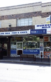 Glen Eira Historical Society
Photograph, Murrumbeena Road, 229A, Murrumbeena, 2001
Originally labelled "Beauville Estate, Established 1936, Still Thriving 65 years on, 10th March 2001", the Beauville Estate Album contains colour photographs of houses in the Estate. They were taken around the time of the Beauville Estate’s 65th Heritage Celebration held on 10/03/2001 and donated to the Caulfield Historical Society shortly afterwards. Photographer unknown. From Glen Eira’s Heritage Management Plan by Andrew Ward (1996) Vol 2 p78: In Murrumbeena Road, the shops which form part of the estate are a simple cream brick row relieved by manganese bricks in bands across the upper storeys.City of Glen Eira’s Heritage Management Plan Vol 2 p79 (this is p84 of the pdf version) – HO12 Beauville Estate and environs, Murrumbeena: The Beauville Historic Area is important at the State level as the first large housing estate undertaken by the AV Jennings Construction Co, later Jennings Group Limited, Victoria’s largest home builder. It is important also as a very early estate development incorporating a range of features other than houses and including made roads, shops and recreation facilities. In this respect it was the forerunner of the comprehensively planned housing estate of the post war era. The estate is distinguished by its aesthetic values, as is the earlier and comparable Hillcrest Estate, which are formed by a combination of restrained diversity in house styles, with the exception of no. 30 in the emerging International style, and by a landscaped garden environment. Colour photograph of a section of a double storey, unpainted brick, commercial property containing shops at ground level all with awnings over the footpath. This specific property is a fish and chip shop. The upper storey brick residence features a curtained window, a flat roof and decorative two tone bands of brickwork. It has a large street seat on the footpath out front.BLUE SEA FISH & CHIPS / TAKE AWAY FOODmurrumbeena, architectural styles, 1930's, inter war style, a.v. jennings, av jennings, jennings, beauville estate, murrumbeena road, milk bars, commercial establishments, flats, fish & chip shops, sir albert victor jennings, a v jennings construction co, beauville estate heritage area, glen eira city council, architectural features, jennings group limited, land subdivision, beauville historic area, brick features, restaurants -
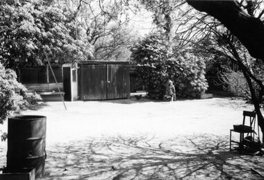 Surrey Hills Historical Society Collection
Digital photo, George L Coop, Back yard of 686 Whitehorse Road, Mont Albert c 1953, c1953
This is a photo of the backyard of the property adjacent to the Coop's home. At the time the neighbours were Mrs Daisy McKernan (a widow) and her son Alexander Colin McKernan. The clothes line prop was a forerunner of the clothes hoist. Clothes line props were standard purchase items at many local hardware stores and the donor poetically described them as holding "long lines of drying washing above the dusty democracy of many a rough back yard." Whilst the Coop home is still extant in 2019 and used as professional rooms for Dr Peter Chau, an eye surgeon, 686 Whitehorse Road has been replaced by units. This captures the utilitarian nature of the 'typical' back yard before the advent of rampant consumerism. Large areas of open lawn were a desirable central feature, often edged with neatly contained garden beds. Better lawnmowers, plus the promotion of new chemicals and fertilisers to help home gardeners grow the perfect lawn. Missing is the rotary hoist and the vegetable garden.A black & white photo on a sunny day of a backyard with the following features: a timber shed, an additional shed / hen house, a hand lawn mower leaning against a tree, several hens and a metal drum (perhaps used as bonfire container). A sloping pole/prop may be seen on the left. backyards, (mrs) daisy mckernan, alexander colin mckernan -
 Ringwood and District Historical Society
Photograph, View of Glenvale Road, Ringwood 1964
See Also #25Written on back of photograph, "1964 - View of Glenvale Road. Supplied by Garrett Gundry. Warnes Road in left background. Deep Creek Road in centre background." -
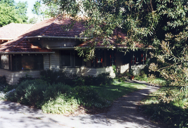 Whitehorse Historical Society Inc.
Photograph, 443 Mitcham Road, Mitcham, 1998
Eric Roger Webb moved to Mitcham with his family in about 1932. They lived at 443 Mitcham Road and owned all the land up to Simpson Street. The land was a grass paddock and he planted native trees and shrubs around the perimeter. The Webbs has three children: Eric, Dean and Donald. Mr Webb worked in the public service. He was a councillor of the Shire of Blackburn and Mitcham and later of the city of Nunawading between 1940 and 1949. He was also a Shire President from 1943-1944.Coloured photograph of a house at 443 Mitcham Road, Mitcham. Tiled roof, verandah, path leading to front door.443 mitcham road, mitcham, houses, webb, eric -
Whitehorse Historical Society Inc.
Map, Springvale Road, 1981
Aerial photograph of area including cnr. Springvale Road and Burwood Highway, south past Highbury Road and west to Sevenoaks Road.Aerial photograph of area including cnr. Springvale Road and Burwood Highway, south past Highbury Road and west to Sevenoaks Road.Aerial photograph of area including cnr. Springvale Road and Burwood Highway, south past Highbury Road and west to Sevenoaks Road.aerial photographs, burwood east, springvale road, burwood east, burwood highway, burwood east, sevenoaks road, burwood east, highbury road, burwood east