Showing 3069 items matching "scales"
-
 Greensborough Historical Society
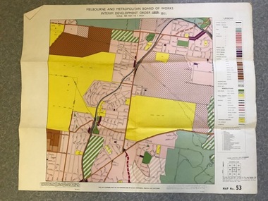
Map, Melbourne and Metropolitan Board of Works Interim Development Order 1961 Map No. 53, 27/09/1961
Denotes Zones and Reservations comprising part of the municipalities of Eltham, Heidelberg, Preston and Whittlesea, approved 27.9.61. Includes Mont Park Hospital and Watsonia Military Camp.Colour plan Date printed on plan (1959) has been over stamped with 1961. Also stamped with Government Gazette date of 27.9.1961. "Scale 800 feet to 1 inch"greensborough, watsonia -
 Glenelg Shire Council Cultural Collection
Plan - S.S Admella Model Plans, n.d
Photocopy of sale/rigging plan of S.S Admella scale 1:48. Photocopy on parchment style paper. Plan used by 'float-a-boat' model markers for the construction of the Admella model acquired by Grant District council.admella, portland lifeboat, 150th anniversary -
Glenelg Shire Council Cultural Collection
Functional object - Astro Compass, n.d
Astro compass, metal, used in aircraft, Star System rather than Solar System. Painted black, various scales of measurement marked in white: north red N in square. Screws in base for ? levelling, ? mounting. -
 Orbost & District Historical Society
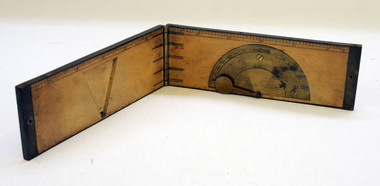
clinometer rule, mid 19th -earl 20th century
This clinometer, is a hand-held optical scientific instrument used in surveying to measure vertical angles. It is used to measure the angle of elevation from the ground in a right-angled triangle. It may have been used by a surveyor or a forester to measure the height of tall things where you couldn't possibly reach to the top of e.g. flag poles, buildings or trees.This item is an example of an early hand held measuring instrument.. Today the use of electronic sensors is an important component in the design and function of the clinometers.A rectangular wooden folding measuring instrument. the panels are brass framed. Inside is a brass semi-protractorgraduated 90-0-90' with index arm pointeran dwith a graduated edge in inches. Outside is a temperature conversion scale,Troughton & Simms, LONDONscientific-instrument measurement clinometer -
 Orbost & District Historical Society
plan, before 1948
Drainage infrastructure was developed and maintained in this region by the Snowy River Improvement Trust. The Trust was administered by a local committee and its activities funded by a local rate charged on the farmers and land owners in the Trust’s designated district. The level of the rate charged by the Trust was designed to be proportionate to the benefit derived from the works undertaken. Financial assistance was provided by the State Government from time to time for specific projects such as post flood repairs but not for new capital works. The Trust undertook new drainage and river management works including tree planting, rock beach construction and servicing of the drains and flood gates. The Trust also provided a personal flood warning service to the farmers in its district. The Trust ceased to operate in 1997 with the advent of the East Gippsland Catchment Management Authority. The infrastructure developed by the Trust continues to provide a service to the farmers in the region. (ref. 4 East Gippsland CMA Submission to Inquiry into Flood Mitigation Infrastructure in Victoria) This plan is significant as a historical document. The Snowy River Improvement Trust was vital to the Orbost district because of its ability to apply local knowledge and to engage the local farming community.A large plan of divisions of land for the purpose of levying the Snowy River Improvement District - Bete Bolong, Orbost, Waygara, Newmerella and Orbost East. The properties are coloured according to levy amount. The scale is 1" - 20 chains. snowy-river-improvement-trust -
Federation University Historical Collection
Map, Town of Buninyong, 1927, 09/1927
The date of this map is September 1927 revised from the original 1910 map. Buninyong was created a district on 09 July 1858, proclaimed a Shire on 16 February 1864, and the Buninyong Borough united on 01 October 1915.Township plan of the Town of Buninyong showing government roads and crown allotments. Earlier detail pencilled on (commercial buildings, etc) appears to be from an 1850 survey. Scale: 4 chains to 1 inch (1:3168)buninyong, map, buninyong botanical gardens, tannery dam, buninyong reservoir, chapel school, rev. hastie -
 Federation University Historical Collection
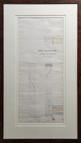
Drawing - Architectural Plan, Ballarat School of Mines Gauge Tower Architectural Plan by Henry Richards Caselli, 04/11/1880
The Ballarat School of Mines was the first of its type in Australia. The Albert Street frontage was the 'working end' of the campus with the mining laboratory, gauge tower and caretakers cottage. All the structures in the foreground have been demolished to make way for the Flecknoe Building and the M.B. John Building. The gauge tower is also depicted in the 1881 Annual Report.Original double mounted and framed architectural plan for the Ballarat School of Mines Gauge Tower. The plan includes sections and elecation. Some areas have been coloured, and the drawing is at a scale of four feet to one inch. Verso in ink "Gauge Tower School of Mines" Signed left "H.R. Caselli architect 4.11.80henry caselli, henry richards caselli, architectural plan, ballarat school of mines, gauge tower, buildings, architect -
Bendigo Historical Society Inc.
Map - CAMPBELL COLLECTION: BENDIGO & DISTRICT MAPS, 16-5-29
Map. Egerton, Parishes of Egerton and Whirrakee, scale 20 chains to 1 inch. Total area 5401 acres. Prepared in W.P.B. from A. and C.L. Plans by W.J. Galbraith (number 376 in map cupboard 1)W.J.Galbraithmap, bendigo, agricultural lands -
Bendigo Historical Society Inc.
Map - CAMPBELL COLLECTION: BENDIGO & DISTRICT MAPS, 5-4-28
Map. Sedgwick, Parishes of Strathfieldsaye, Lyell and Sedgwick. Scale 20 chains to 1 inch.Total area 5372 acres. Prepared in W.P.B. from C.l. and A. Plans by W.J. Galbraith. (number 374 in map cupboard 1)W.J.Galbraithmap, bendigo, agricultural lands -
Bendigo Historical Society Inc.
Map - CAMPBELL COLLECTION: BENDIGO AND DISTRICT MAPS
Map. Mandurang, Parish of Mandurang, Scale 20 chains to 1 inch. Total area 5993 acres, Northern Railway to left of map, Water Reserve (Spring Gully). (number 363 in map cupboard 1)map, bendigo, allotments -
Bendigo Historical Society Inc.
Map - CAMPBELL COLLECTION: BENDIGO AND DISTRICT MAPS
Map. Lockwood, Parishes of Lockwood and Shelbourne, scale 20 chains to 1 inch. Spring Creek centre of map and Bullock Creek to the right. Total area 4405 acres. (number 358 in map cupboard 1)map, bendigo, allotments -
Port Melbourne Historical & Preservation Society
Map - MMBW, 1897
Melbourne and Metropolitan Board of Works 1895, Plan No. 324, 328, 329 Segments shown: (as plan No's.) Large scale showing hotels, civic and industrial buildings, Graham Street to Bay, Nott and Dow Streets.engineering - board of works, business and traders - hotels, built environment, piers and wharves - town pier, transport - tramways -
 Whitehorse Historical Society Inc.
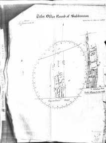
Document - Land Title, Titles Office Record of Subdivision, 25/11/1885
Photocopies of record of subdivision of David Boyle's land in Canterbury Road, Forest Hill covering the period from November 1885 to February 1898 including a scale drawing of the land and the creation of an easement for Mount Pleasant Road.boyle, david, walter, william james, joseph nash, alexander, janet kennedy, furborough, henry, canterbury road, forest hill, mount pleasant road, land subdivision -
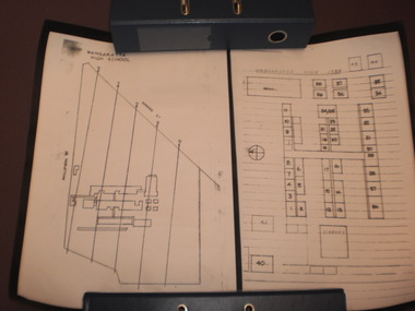 Wangaratta High School
WHS Map Drawings, 1984
Two black and white rolled-up scaled drawings of the existing school buildings with labelled classrooms, each mounted on black card. This item is was a part of a time capsule buried in Wangaratta High School grounds in 1984 -
Beechworth Honey Archive
Map- Beechworth
(3x) Map centred on Everton, Beechworth and Eldorado. Map shows Ovens River, Wangaratta- Beechworth Rd., Chiltern- Beechworth Rd., and Ovens Highway. Scale 1:50,000. Back of map white, front is yellow.Albury series R.652 (Beechworth) Two copies have towns shaded red. One copy has locations of dams marked. ca 1974-1975.map, beechworth, everton, eldorado, paper, beechworth honey -
University of Melbourne, Burnley Campus Archives
Plan, Ian Robertson, Student Gardens Burnley Campus, 1989
Plans on tracing paper by Ian Robertson. Scale 1:50. 1. Planting Plan, Sheet No 5, 19.5.89. 2. Master Plan, Sheet No 6, 6.6.89. 3. Preliminary Plan Sheet No 4, 19.5.89.ian robertson, burnley campus, student gardens -
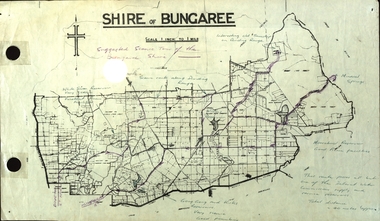 Federation University Historical Collection
Plan, Shire of Bungaree
The former Shire of Bungaree is now part of Moorabool Shire.Plan of the Shire of Bungaree. Scale is 1 inch to 1 mile with the total distance approximately 40 miles. Includes Gong Gong Reservoir, Kirks Reservoir, White Swan Reservoir, Wilson's Reservois and Moorabool Reservoir. Purple line in purple pencil indictaes suggested scenic tour of the Bungaree Shirebungaree, water supply, barkstead, humffray street, ballarat, doveton (north) stret, ballarat, ballarat water commission, great dividing range, wombat state forest, mineral water springs, gong gon reservoir, kirks reservoir -
Glenelg Shire Council Cultural Collection
Plan - Plans / Line Drawings - Port of Portland Slipway bilge blocks, fishing vessel Kosmo, Portland, Victoria, 13/01/1988
PORT OF PORTLAND AUTHORITYFront: '1' black texta, top right corner -
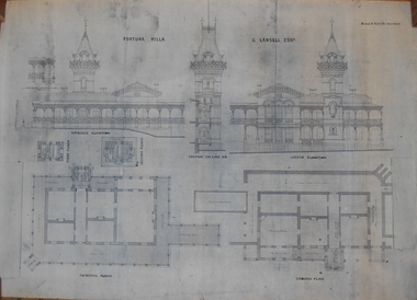 Bendigo Historical Society Inc.
Plan - MARKS COLLECTION: PLAN OF FORTUNA VILLA
Copy of overall plan for Fortuna Villa. Plan shows entrance and garden elevations, ground plan and principal floor plan. Written on top of plan 'G Lansell Esq' 'Scale 8 feet to 1 inch'.bendigo, house, fortuna villa -
University of Melbourne, Burnley Campus Archives
Plan, Rough Interim Plan of Agricultural College Estate Dookie, 1964
Plan of Dookie College showing buildings, numbered paddocks with acreage, other details (windmills, tanks, troughs, dams) named. Key to soil types. Dated April 1964. Scale 1 inch to 28 chains.paddocks, dookie agricultural college, soils, dookie area -
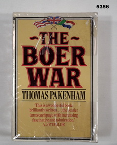 Bendigo Military Museum
Book - BOOK, BOER WAR, Thomas Pakenham, The Boer War, 1982
" The Boer War" Thomas Pakenham has written the first full scale history of the war since 1910.Soft cover book with soft plastic dust cover. Soft cover - cardboard, black and red coloured print on front, spine and back. Yellow colour background. Top front page in colour, 3 flags illustration. 659 pages, paper, cut, plain, white. Illustrated black and white photographs, maps and illustrations. Owner's label on front end paper. Soft plastic dust cover.Front end paper - printed owner's label " W & E R van der Eynden/ 6 Elvey Drive/ Kangaroo Flat 3555/ Victoria, Australia". Lower edge of pages - felt tipped pen, black ink - line drawn.books, history, the boer war -
 Orbost & District Historical Society
weights
Rectangular weights like these were often used with platform scales used for weighing large items or bags.Five rectangular cast iron handled weights - one smaller than the other four. Each of the larger ones has a moulded ring in the middle of the top. The smallest one is cubic and has a small rectangular recess in the front.On the top is a small oval shape on a stem. cast-iron weights -
 NMIT (Northern Melbourne Institute of TAFE)
Newsletter, Northcote Nursery Newsletter Spring 1998, 1998
Northcote Nursery News contains general information on gardening - growing tomatoes and lawns, scale control, etc. 8 pages, printed on A3 pale greeen paper and folded and stapled to A4 size.northcote nursery, gardening, horticulture, nmit. -
Creswick Campus Historical Collection - University of Melbourne
Equipment, Ranging 120
Black case with lens and scale. For measuring 2 - 30m distance, height, width. In original cardboard box.Equipment -
 Whitehorse Historical Society Inc.
Map - Public Lands Office map, Public Lands Office, Melbourne, Village of Ballyshanassy, 1858, 10 April 1858
A map of the Village of Ballyshanassy by the Public Lands Office, Melbourne. Scale 12 chains equals 5 cmsballyshanassy, parish of nunawading -
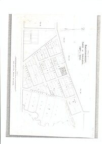
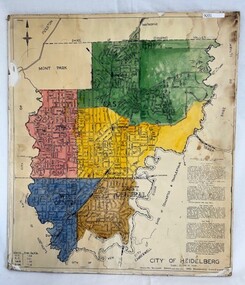 Greensborough Historical Society
Poster - Map, City of Heidelberg, 1965c
Map of the City of Heidelberg showing municipal boundaries and Wards are coloured. Scale 20 chains to 1 inch.An example of hard copy plans from the 1960s. Mainly from the Shire of Diamond Valley era (1964-1994).Colour map, pasted on card and laminated.Stamped and handwritten Council permissions, dates and other details. city of heidelberg, heidelberg - maps, local government -
Glenelg Shire Council Cultural Collection
Photograph - Photograph - aerial view of Portland, c. 1954
Black and white aerial photograph of coastline around Portland. Black border, scale all sides, 5 rows of 3 't' at regular intervals.Mostly ocean, strip of land down right hand edge and across bottom.Front: '607 - 55 ' - handwritten, white, border 'RUN 7 'PORTLAND', printed, white, borderaerial photography, central portland, portland harbour, south west coastline -
Glenelg Shire Council Cultural Collection
Photograph - Photograph - Aerial view of coastline around Portland, Victoria, c. 1954
Black and white aerial photograph of coastline around Portland. Black border, scale all sides, 5 rows of 3 't' at regular intervals. Top half is ocean, bottom half is ? beach; sand dunes, cliffs.Front: '607 - 61 ' - handwritten, white, border 'RUN 7 PORTLAND', printed, white, border -
Glenelg Shire Council Cultural Collection
Photograph - Photograph - aerial view of Portland, c. 1954
Black and white aerial photograph of coastline around Portland. Black border, scale all sides, 5 rows of 3 't' at regular intervals. Further along to left, almost straight 60/40 ocean to land.Front: '784 - 152' - handwritten, white, border 'RUN 7 A PORTLAND', printed, white, borderaerial photography, central portland, portland harbour, south west coastline -
Glenelg Shire Council Cultural Collection
Photograph - Photograph - aerial view of Portland, c. 1954
Black and white aerial photograph of coastline around Portland. Black border, scale all sides, 5 rows of 3 't' at regular intervals. Fifty percent ocean, 50 percent land. See 'Other Information'Front: '820 -49' - handwritten, white, lower border 'RUN 6' 'PORTLAND', printed, white, lower borderaerial photography, central portland, portland harbour, south west coastline