Showing 4553 items matching "the avenue"
-
 Greensborough Historical Society
Photograph - Digital image, Marilyn Smith, Poulter Avenue Reserve 2016, 11/08/2016
Photograph of Poulter Avenue Reserve Greensborough. Digital copy of colour photograph.poulter avenue greensborough, poulter avenue reserve greensborough -
 City of Ballarat Libraries
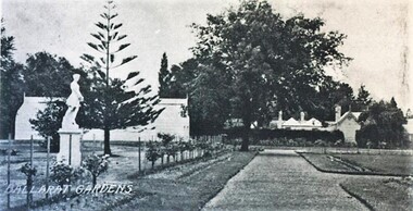
Postcard - Card Box Photographs, Keel Glasshouse and Caretaker's House, Ballarat Botanic Gardens 1929
This area is now the Prime Minister's Avenue.keep glasshouse, caretaker's house, ballarat botanic gardens, gardens, building, public, statues -
 Phillip Island and District Historical Society Inc.
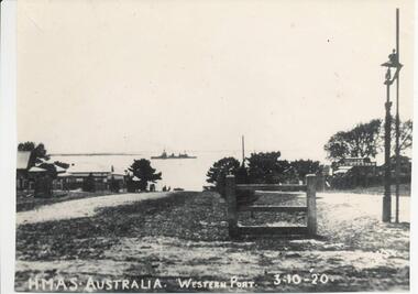
Photograph, 3/10/1920
This postcard is contained in an album presented to the then Governor of Victoria, The Earl of Stradbroke, by the fathers of soldiers & returned soldiers of Phillip Island, on 16/02/1923. The history of the album is noted on Reg. No 85-00Postcard of view of Thompson Avenue looking north to HMAS Australia in Western Port Bay, 3-10-1920; a gas lamp, the first cypress trees and the first motor garage.local history, photography, photographs, slides, film, hmas australia, thompson avenue, shipping, sepia photograph, cypress trees first planting -
 Phillip Island and District Historical Society Inc.
Photograph, 3/10/1920
One of a collection of over 400 photographs in an album commenced in 1960 and presented to the Historical Society by the Shire of Phillip IslandPhotograph looking north along Thompson Avenue from Chapel Street. HMAS Australia shown in the distant between Cowes and Sandy Point. Part of Cowes Garage also depicted.local history, photography, photographs, film maritime technology, boats, thompson avenue - hmas australia - cowes garage, black & white photograph, cowes, thompson avenue, shipping, hmas australia, cowes garage, john jenner, bryant west -
 Ringwood and District Historical Society
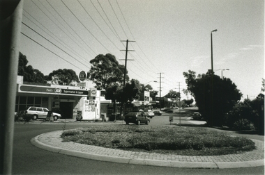
Photograph-B&W, Joan Walker, East Ringwood 2000- Roundabout in Railway Avenue cnr Wenwood Street looking West (railway line on right hand side), 2000
East Ringwood 2000- Roundabout in Railway Avenue cnr Wenwood Street looking West (railway line on right hand side)- B&W Photo from Album 6501 -
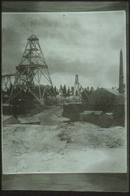 Bendigo Historical Society Inc.
Slide - ALBERT RICHARDSON COLLECTION: LANSELL'S 222 MINE
Slide.Lansell's 222 Mine. Poppet head on LH side of image, mine sheds and brick chimney called Cleopatra's Needle, on extreme RH side. Large avenue of trees in background.mine, gold, 222 mine, bendigo mines-jack hattam collection -
 Whitehorse Historical Society Inc.
Photograph, 22 Pakenham Street, Blackburn, C.1950
Black and white photo of 22 Pakenham Street, Blackburn, looking West. Left hand corner is the dirt strip of Salisbury Avenue, Blackburn, heading up the hill to Middleborough Road. -
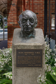 Bayside Gallery - Bayside City Council Art & Heritage Collection
Sculpture - bust, George Luke, Alan Marshall, 1985
Alan Marshall (1902-1984) was an Australian writer, storyteller, social documenter and author of 'I Can Jump Puddles'. He lived for many years in Sandringham. This work was commissioned by Sandringham Council and unveiled in May 1985 at the opening of the new Sandringham library.George Luke, Alan Marshall 1985, bronze. Bayside City Council Art and Heritage Collection. Commissioned 1985Cast bronze head of Alan Marshall. The head is mounted on a cement pedestal with a bronze plaque with inscription at the front. Located at Sandringham Library, Corner Waltham Street and Chalmers Avenue, Sandringham.alan marshall, george luke, scultpure, portrait, bust, sandringham, library, writer, social documenter, australian author -
Kew Historical Society Inc
Archive (Sub-series) - Subject File, Kew Historical Society, HOLT, Dame Zara, 1968
Various partiesReference, Research, InformationSecondary Values (KHS Imposed Order)The subject file contains Part 2 of a newspaper article, written by Dame Zara Holt, published in the Herald Sun in 1968. The article records aspects of her upbringing in 17 Ridgeway Avenue and at school at Ruyton.dame zara holt, 17 ridgeway avenue - kew (vic), herbert dickens, violet dickens, ruyton girls school - former studentsdame zara holt, 17 ridgeway avenue - kew (vic), herbert dickens, violet dickens, ruyton girls school - former students -
Canterbury History Group
Ephemera - Entertaining will be a delight!, [2004]
Real estate advertisement for the sale by auction of 30 Monomeath Avenue Canterbury on Saturday 6 November [2004]. Includes coloured photographs of the interior and exterior of the house and floor and site plans.canterbury, monomeath avenue, swimming pools, peacock family -
Canterbury History Group
Ephemera - 32 Victoria Avenue, Canterbury, [1999 or 2004]
Real estate advertrisement for the sale by auction of 32 Victoria Avenue Canterbury on Saturday 4 December [1999 or 2004]. Includes a coloured photograph of the exterior of the house and floor and site plans. -
Canterbury History Group
Ephemera - Faversham Mews - stunnning open plan living, 1/02/2011 12:00:00 AM
Real estate advertisement from the Weekly Review for the auction of 4/43 Faversham Avenue , Faversham Mews , Canterbury on the 26 February 2011. Includes coloured photographs of the interior and exterior.canterbury, faversham mews, faversham road, townhouses -
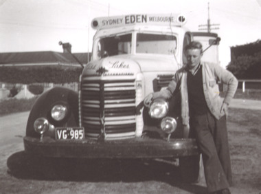 Lakes Entrance Historical Society
Photograph - Hancock Trucking, Charlie Hancock Jnr, 1950 c
Black and white photograph showing Charlie Hancock Jnr standing by a truck used to transport fish taken opposite Rosemont Guest House Barkes Avenue Lakes Entrance Victoriatransport, fishing -
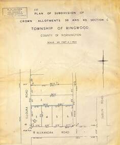 Ringwood and District Historical Society
Map - Plan of Subdivision, Part of Crown Allotments 39 and 40 Section C, Township of Ringwood, County of Mornington - (Undated - circa 1930s)
Copy of land title map on light cardboard backing showing layout and size of 6 allotments in Illoura Road (later Illoura Avenue) and Alexandra Road, Ringwood East, Victoria. Rubber stamp imprint in top left corner - D.H. Oliver, Civil Engineer & Licensed Surveyor, Bellevue Street Lilydale, Phone Lilydale 91. -
 Eltham District Historical Society Inc
Photograph, Baldwin Avenue at Lilicur Road, Montmorency, c.1972, 1972c
Shire of Eltham road construction and realignment works on Baldwin Avenue, Lilicur Road and Price Avenue, Montmorency, c.1972 Cross Ref: EDHS_03867 (1972) EDHS_04005-10 (1980) EDHS_04774-1 (2019)35mm colour positive transparency blue Agfacolour Service plastic mountbaldwin avenue, infrastructure, lilicur road, montmorency, road construction -
 Kew Historical Society Inc
Plan - Subdivision Plan, H C Crouch, Old Golf Links Estate, 1930s
The land in North Kew between the Outer Circle Railway and the River Yarra was released in sections. This release included 80 lots. Most of this area was released during the Depression years in the early 1930s.Subdivision plans are historically important documents used as evidence of the growth of suburbs in Australia. They frequently provide information about when the land was sold on which a built structure was subsequently constructed as well as evidence relating to surveyors and real estate and financial agents. The numerous subdivision plans in the Kew Historical Society's collection represent working documents, ranging from the initial sketches made in planning a subdivision to printed plans on which auctioneers or agents listed the prices for which individual lots were sold. In a number of cases, the reverse of a subdivision plan in the collection includes a photograph of a house that was also for sale by the agent. These photographs provide significant heritage information relating house design and decoration, fencing and household gardens.One part of a massive subdivision of the Old Golf Links Estate in North Kew of 80 allotments bordering Sutherland Avenue, Ramsay Avenue, Belford Road, Beresford Street and Coleman Avenue. Inset on the plan at the top left, the route of the Outer Circle Railway is clearly marked. The Kew Golf Links is identified in its current location. The land on which Greenacres Golf Club was to be constructed is at this time marked as ‘Recreation Ground’. The ‘new bridge’ over the Yarra at Burke Road is also marked on the inset map. The Plan identifies the surveyor (sic) H.C. Crouch BCE MVIS, 443 Little Collins St., Melbourne. The date of the subdivision auction sale in identified as Saturday September 25th at three o'clock.Annotations: "E" top left. "Golf Links" top right. Lots 73-76 ticked and listed as "6" poundssubdivisions -- kew (vic.), old golf links estate -
 Phillip Island and District Historical Society Inc.
Photograph, 1940's
One of a collection of photographs purchased from Photo First, Thompson Avenue, Cowes, when it closed down in June 2014. Photograph of The Esplancade near corner of Bass Avenue. Tennis Courts belonging to Yackatoon or Continental.Large Black & White photograph of The Esplanade, Cowes showing cars, tennis courts and Moreton Bay fig in the foreground.the esplanade cowes, moreton bay fig, photo first phillip island -
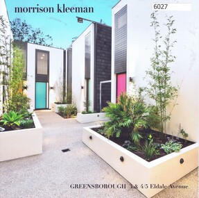 Greensborough Historical Society
Advertising Leaflet, 3 & 4/5 Eldale Avenue Greensborough, 14/03/2018
3/5 Eldale Avenue Greensborough, 2 bedroom town house, sold March 2018 for $595,000. Previous sales: June 2000 $184,000. 4/5 Eldale Avenue sold February 2018 for $610,000Real Estate advertising leaflet,1 sheet folded into 4 pages, printed in colour both sides.eldale avenue greensborough -
 Phillip Island and District Historical Society Inc.
Photograph, 1940's
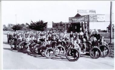
RACV Garage in Thompson Avenue. "Thompson's Garage".Black & White photograph of community of Cowes with tyres collected for the war effort in front of Thompson's Main Garage.Tyres collected for the war effort - 1940'swar effort collection, thompson's garage cowes phillip island, sue payne -
 Greensborough Historical Society
Photograph - Digital Image, Somers Avenue Macleod, 1950s
Digital of streetscape, possibly Somers Avenue Macleod.Digital image of black and white photograph.somers avenue macleod -
 Greensborough Historical Society
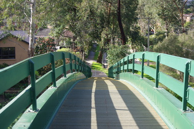
Photograph - Digital image, Marilyn Smith, Poulter Avenue Reserve Bridge 2016, 11/08/2016
Photographs of the footbridge at Poulter Avenue Reserve Greensborough. Digital copy of colour photograph.poulter avenue greensborough, poulter avenue reserve greensborough -
 Greensborough Historical Society
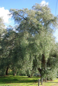
Photograph - Digital image, Marilyn Smith, Poulter Avenue Reserve Trees 2016, 11/08/2016
Photographs of trees at Poulter Avenue Reserve Greensborough. Digital copy of colour photograph.poulter avenue greensborough, poulter avenue reserve greensborough -
 Halls Gap & Grampians Historical Society
Photograph - Sepia
"Wonderland Avenue, Grampians" printed in white on photograph.Rocky formations. Mountain range in the background. Straggly trees in foreground beside large boulders.scenery, wonderland range -
 Port Fairy Historical Society Museum and Archives
Postcard
Road to the East beach probably Bourne AvenueRoad to the beach Port Fairyeast beach, bourne avenue, tea teee -
 Ringwood and District Historical Society
Plan - Proposed Ringwood East Railway Station, VR Ringwood-Croydon (Dublin Road) - 1923
Technical drawing of "Proposed Station At 16Mls 38Chs 89Lks (Dublin Road)" inluding boundary line, red shaded platform with station buildings, and green shaded possible future "up" track. Surrounding streets include Dublin Road, Patterson Street, and subsequent hand-written additions of Railway Avenue, Lawrence Grove, Stanley Avenue, Wenwood Street, and Lois Street. Land title details of Patterson Street properties mainly illegible.Scale: 40'=1". Possible future (platform) extension for 8 car trains (and) extension for 10 car trains. -
 Eltham District Historical Society Inc
Photograph, Baldwin Avenue at Sherbourne Road, Montmorency, c.1972, 1972c
Shire of Eltham road construction and realignment works on Baldwin Avenue, Lilicur Road and Price Avenue, Montmorency, c.1972 Cross Ref: EDHS_03878 (1972) EDHS_04005-9 (1980) EDHS_04774-2 and EDHS_04774-3 (2019)35mm colour positive transparency blue Agfacolour Service plastic mountbaldwin avenue, infrastructure, road construction, sherbourne road -
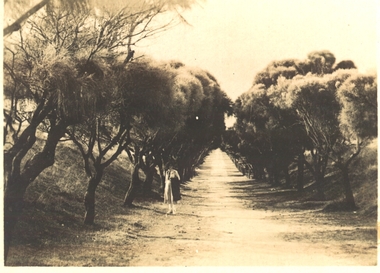
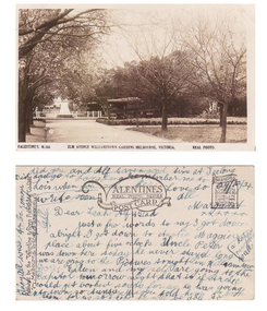 Williamstown Botanic Gardens- Hobsons Bay City Council
Postcard - Williamstown Botanic Gardens, circa 1900-1924
The original postcards in this series (2013.002 to 2013.018) were generously loaned to Williamstown Botanic Gardens by a private collector for copying. The postcards are evidence of the interest the gardens held as a subject for postcard publishers. The text and images provide a snapshot into fashions, social interests and concerns of the time. The professionally produced images provide a pictorial history of Gardens including changing planting styles, various structures and features of the Gardens eg the aviary, cannons, the fountain, the second Curator’s Lodge and gates. The images offer an opportunity to compare garden vistas with the present day. This postcard is evidence of the placement of two of the cannons relocated from Fort Gellibrand in 1906 and that they were in place in the Gardens in 1924. They were removed from the Gardens in the 1960s. These same cannons remain a feature on the Williamstown waterfront in 2013. The image also shows the original Elm Avenue plantings. A sepia scene looking west towards statue of Alfred Thomas Clark, with cannons on either side of statue pointing east down what is known as the Palm Avenue. The statue is surrounded by a white fence consisting of posts and a top rail. The top of the statue is hidden by the branches of the elm trees. It appears that the elms are in the process of either losing their leaves or new leaf growth. A cactus plant can be seen beneath the lower branches of the elm tree of the right closest to the camera. The cannons were moved from Fort Gellibrand to the Gardens in 1906.Front: VALENTINE’S, M.356 ELM AVENUE WILLIAMSTOWN GARDENS MELBOURNE, VICTORIA. REAL PHOTO. Reverse: vertical on left side of card and underlined: ‘Published by the Valentine & Sons Publishing Co. Ltd. / Melbourne, Sydney & Brisbane’. Top centre of card: Contains logo of ‘VALENTINES / REAL PHOTO SERIES / POSTCARD’. Top right hand corner is stamped ‘BRANCHES (enclosed in a scroll) / SYDNEY / LONDON / DUNDEE / DUBLIN / CAPETOWN / MONTREAL / TORONTO’ The card is dated ‘29/12/24’ and addressed to ‘Dear Leah Alf & Dad’ signed by ‘Margaret’. postcard, gardens, post-card, williamstown-botanic-gardens, hobsons-bay-city-council, statue, clarke, alfred-thomas-clarke, cannon, elm, cactus, 1924, fort-gellibrand, 1906, armstrong, clark -
Phillip Island and District Historical Society Inc.
Photograph, circa 1940
Commercially available print made approx 1940s. Bayview Guesthouse burn down in 1950s.L shaped Jetty, left, Jetty Shed at end. Large trees along beach front. Thompson Avenue middle showing most buildings on right. Bayview Guesthouse in foreground right.Valentine Series (rest cut short)local history, photography, photographs, slides, film, aerial view of cowes, black & white photograph, foreshore, jetty -
 Phillip Island and District Historical Society Inc.
Photograph, 1978/79
This was Arnie Brown's house in the main street of Cowes. Arnie lived at Hastings, but came to live on Phillip Island in 1908. One of the best known boatman - he provided fishing trips for visitors. He died in the autumn of 1952 from an accident when tying up at Cowes Jetty. He had numerous fishing boats.Old house in Thompson Avenue, Cowes. Red iron roof, red tank on stand on left hand side of picture. Verandah around front of house. Note double wire gates.local history, photographs, historic, buildings - historical, coloured photograph, john cook, phillip island, arnie brown -
Ringwood and District Historical Society
Biography, Ringwood and District Historical Society, Interview notes - short biography on Miss Daisy Paddock, teacher at Ringwood State School, circa 1970s, c.1970s
Single page of notes/interview record of Miss Daisy Paddock, teacher at the Ringwood State School in Greenwood Avenue (now Federation Estate) - Interview write-up by Ringwood History Group.Transcript: "Miss Janet Daisy Paddock She was an extremely well-liked and well-regarded teacher at the old RW State School in Greenwood Ave (Now Federation Estate). She taught between the years of 1927 until 1941, then again after the war from 1951 until final retirement in 1961. In fact she was so liked that her former pupils formed "The 2997 Club" , which met in her honour every year for a meal (and, of course, their guest of honour). 2997 was the RW SS number. In some of her letters about early life in RW, she recalls the RW Mail being produced and printed in a small wooden building in Adelaide St. [Adelaide St is officially no longer on the RW map but it went from the highway nearly to Mullum Creek, between Melbourne St and Warrandyte Road.^ In fact there is an unmarked 100 metres of road that is on the west side of Officeworks that ends in a roundabout at the bottom of Eastland carpark. I don't believe it is exactly in the same position as the old Adelaide Street but it pretty close. That would put the old Mail office in the vicinity of the Maroondah Council service centre in Eastland.] She also recalls that there were nearly a dam on every corner. In fact, I recall in my 1950s/60s childhood that there were still many dams around. As I previously mentioned, with the RW-Mitcham claybelt, there wasn't much top soil and the orange clay is very fine, so when the banks of the dam get wet, it wass very slippery. I often remember playing around in those dams, as most boys did in those days. A friend and I spied an old bath used to water some horses so after some trial and errors we made it waterproof and fashioned a couple of paddles out of wooden fence pailings. The first launch in the local dam was fine and we managed to manouver through the bullrushes into the middle. The only thing that I forgot about was that I had a d<^ that went everywhere with me and, rather than bark from the bank, he swam over to us and tried to get aboard. Bath tubs are not known for their seaworthness and he tipped us all in the drink. Of course the bath sank like a rock. We scrambled on the bank and he added insult to injury when, as all dogs do, gave the usual shake and sprayed us with water. My mind often comes back to one dam right next to the Croydon pub - that provided water to the Magg's orchard - dug in the usual fashion on about 3 metres deep scraped in the local clay, it was at this dam in the early sixties that a young boy drowned. After that we were pretty careful around dams. Going back to Daisy's memories, she recalls that the kids often started late on Monday mornings as Monday was Market Day at RW. They used to watch the stock being herded into the yards and people getting off the steam trains. Her family home was at Gruyere and her father used to drive to RW market and stop midway at the Burnt Bridge hotel and rest the horses. [I suspect that he may have watered other things besides the horses.] They eventually moved to RW in Thanet St. Miss Paddock still remembers the old RW school at the corner of RW St and Whitehorse Road, it was very small so they built the new school in Greenwood Ave. RW had a population of around 2,(K)0 when Daisy became an Assistant Class Five. She used to walk through the open paddocks, surrounded by bush and orchards. She goes on to say that the bush was alive with wildlife and a natural playground for the children. Miss Paddock was a member of the Soroptomist Club in RW (equivalent to Rotary), active in the church and local community. At our archives, we have a plaque that grac^ the entrance to the school, naming it the Miss Daisy Paddock library, in honour of a great woman in our city."