Showing 1291 items matching "western victoria"
-
 Lakes Entrance Historical Society
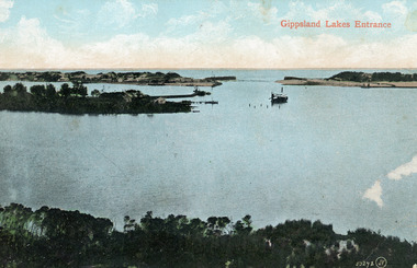
Photograph - The Entrance, 1910c
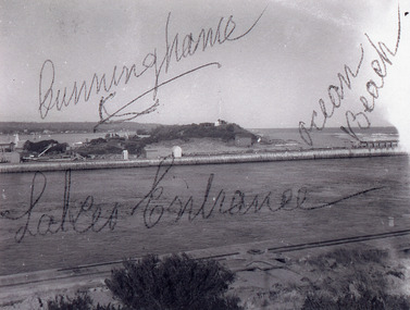
Colour tinted photograph of the entrance from Bass Strait to the Gippsland Lakes. It shows the small village on the hummocks, Bullock Island with bathing boxes at western end, machinery building groyne's from Bullock Island. Boat in the water. Lakes Entrance VictoriaGippsland Lakes Entranceislands, ships and shipping, topography, waterways -
 Whitehorse Historical Society Inc.
Administrative record - Crown Land Valuations and Applications, Government Printer - John FERRES, Crown Lands Pre-emptive Right Applications: Victoria 1850-1854, 1855
Contains a valuation for Crown Lands applications under pre-emptive right by Victorian county, giving names of applicants name of run, area, and remarks.Contains a valuation for Crown Lands applications under pre-emptive right by Victorian county, giving names of applicants name of run, area, and remarks. Contains a valuation for Crown Lands applications under pre-emptive right by Victorian county, giving names of applicants name of run, area, and remarks. clarke andrew, anglesey, evelyn, bourke, dalhousie, dundas, follett, grant, hampden, heytesbury, normanby, polwarth, ripon, talbot, villiers, district of murray, district of wimmera, district of western port, early settlement, mornington -
 Lakes Entrance Historical Society
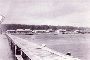
Photograph - Street Scene, 1895c
Also copy 13.5 x 20 cmBlack and white photograph of the western view of the Esplanade, also known as Cunninghame, showing early business houses, and residences. Included is Mrs Gleeson's Boarding House, William Barke's store, Heyfield Coffee Palace, butcher shop. Three small jetties, one substantial jetty and two small boats beside lake. Lakes Entrance Victoriatownship, waterfront, retail trade, jetties -
 Lakes Entrance Historical Society
Postcard - Bullock Island, 1935c
Also faded postcard same imageBlack and white small format postcard of the Princes Highway as it winds around Jemmys Point. It shows the North Arm bridge, narrow bridge to Bullock Island, glimpse of the western part of town, hummocks of southern shore of Cunninghame Arm. Lakes Entrance VictoriaLakes Entrancefences, roads and streets, islands -
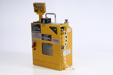 Department of Energy, Environment and Climate Action
Raindance Aerial Incendiary Machine R2
Alan McArthur from the CSIRO began his experimental burning program in the late 1950s near Canberra and published his landmark paper in 1962, “Controlled burning in eucalypt forests”. Leaflet No. 80, as it was known, proved a turning point for forest and fire managers across Australia. It led to the McArthur Forest Fire Danger Meter (FFDM) which first appeared in operational use in 1967 as the Mk 4. The CSIRO had developed its semi-automatic aerial incendiary machine dropping small capsules, with the first trial from a fixed-wing Cessna 337 at Manjimup in December 1965. Many technological and safety improvements followed including the Raindance machineAerial Incendiary Machine developed in Western Australia Rather than "ping pong balls" it uses a belt of incendiary "caplets" which are injected inside the machine before being ejected Raindance Systems R2forests commission victoria (fcv), planned burning, bushfire aviation, bushfire -
 Lakes Entrance Historical Society
Photograph - Harbeck Family, 1939
Sepia toned photograph of three members of the Harbeck family Eva, Jack, Muriel, Frank and visitors from Western Australia standing on waterfront beside Harbeck Jetty. Lakes Entrance Victoriagenealogy -
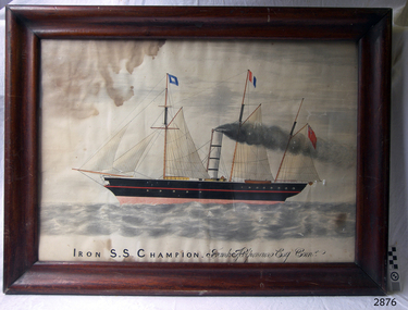 Flagstaff Hill Maritime Museum and Village
Painting - Lithograph, Iron S.S. Champion Frank Helpmann Esq. Comr, 1853 or later
Captain Benjamin Francis (Frank) Helpmann was once the owner of the S.S. CHAMPOIN, then owned it in partnership with S. G. Henty. S.S. CHAMPION was an early steamship and one of the first coastal traders to operate between Melbourne and Portland in Victoria from December 1853 until August 1857, when she collided with the S.S. LIRDY BIRD in the open sea off Cape Otway. CHAMPION was returning from Melbourne, and sank with thirty-two people still on board. The thirty others were saved by the LIRDY BIRD (ref. The Story of a Port : Portland, Victoria, by Noel F. Learmonth)This picture Lithograph) is associated with the S.S. Champion, which is listed on the Victorian Heritage Database VHR S110. The wreck of the SS Champion is significant historically as one of Victoria's worst shipwrecks. As an early steamship it played an important part in the development of and communications between the Western district and Melbourne . Although the site has not yet been located it is predicted to be highly significant archaeologically with the potential to yield information about early coastal shipping and the western district passenger and cargo trade. It is significant technically as an example of an early iron screw steamship, and is part of the western district steamship resource including the SS Casino, SS Coramba and SS Julia Percy.Painting. Lithograph of the schooner S S Champion, hand coloured watercolour, in a cedar frame behind glass. Unusual cross member bracing on the corners of the frame (one missing). Title "Iron S.S. Champion Frank Helpmann Esq. Comr" (in script) on bottom of picture.On the bottom of the painting "Iron S.S. Champion" (in printing), "Frank Helpmann Esq. Comr" (in script) shipwrecked coast, flagstaff hill, flagstaff hill maritime museum, maritime museum, shipwrecked artefact, flagstaff hill maritime village, shipwreck coast, warrnambool, lithograph, frank helpmann, henty -
 Lakes Entrance Historical Society
Photograph - Historic House, 1999
Built 1900c, cottage was made available for widow and children of Dougal Egan, lost when fishing boat Orme disappeared in 1909. After Mrs Egan married George South, cottage became known as the South House. Later resident Mrs Edith Rawlinson. Cottage restumped, refurbished 2011 / 2012.|Also Two colour photographs various viewsColour photograph of a timber cottage at 26 Church Street, with both hipped and gable iron roof. Triple sided bay window. Sash windows on west side, with window hoods. Western wall is on boundary of allotment. Lakes Entrance Victoriahouses, heritage study -
![Map, Plan of Subdivision of Crown Portion 23 & parts 24-25, Parish of Korkuperrimul [1900s?]](/media/collectors/5e461d8021ea67224c82f2a1/items/675fe058304668462205d4fb/item-media/675fe0ef304668462205d7d6/item-fit-380x285.jpg) Bacchus Marsh & District Historical Society
Bacchus Marsh & District Historical SocietyMap, Plan of Subdivision of Crown Portion 23 & parts 24-25, Parish of Korkuperrimul [1900s?]
The Parish of Korkuperrimul includes a significant section of the township of Bacchus Marsh and extends in western and northern directions from the township area. The date of the subdivision indicated on this plan has not been established. The engineer's stamp on the drawing shows the firm of Muntz and Muntz who were operating under that name in the early part of the 20th century.A single page paper map showing 20 blocks of land for sale in the Parish of Korkuperrimul. Scale 100 feet to 1 inch. The map is pasted into a bound volume containing 76 maps or plans in total. High resolution digital image stored on BMDHS computer network. Stamped: 'Muntz & Muntz Civil Engineers, Architects & Surveyors, Trustees Chambers ?? Cor Collins Street and Bank Placeland sales bacchus marsh, bacchus marsh victoria maps, land sales korkuperrimul parish -
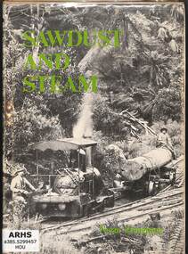 Victorian Railway History Library
Booklet, Light Railway Research Society of Australia, Sawdust and Steam, 1975
... and tramways of the eastern Otway Ranges in South Western Victoria ...A history of the railways and tramways of the eastern Otway Ranges in South Western Victoria.index, ill, maps, p.102.non-fictionA history of the railways and tramways of the eastern Otway Ranges in South Western Victoria.timber tramways - australia - history, narrow gauge railroads - australia - history -
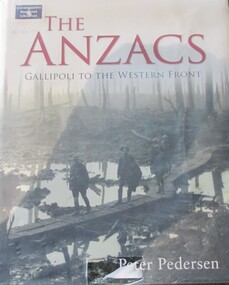 Warrnambool RSL Sub Branch
Book, BOOK: The ANZACS - Gallipoli to the Western Front
-
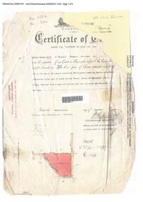 Ringwood and District Historical Society
Document, Certificate of Title - Edward Thomas Miles, Gentleman, "Woorara", Ringwood - part of Crown Section 20, Parish of Warrandyte, County of Evelyn - 1913
A4 copies of damaged Landata Victoria Historical Search documents - Vol 3726 Fol 200 - incomplete proprietor and transfer details.Edward Thomas Miles is now the proprietor of an Estate in Fee-simple subject to the Encumbrances notified hereunder ... 27 acres 19 perches or thereabouts, together with a right of carriage way over roads coloured brown. Subdivision map includes un-named roads - western side is Wonga Road (later Warranwood Road), and eastern side is Grandview Grove (later Bemboka Road), both north of Plymouth Road, Ringwood, Vic. Transfers include (illegible) Dobbs, November, 1927 - 5 acres Harry Temple Marshall, 1st December, 1928 - 10ac 3r David Edward Meyland, 4th October, 194-? (illegible). -
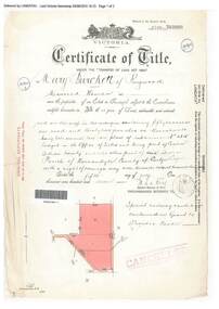 Ringwood and District Historical Society
Document, Certificate of Title - Mary Burchett, Lilydale Road, Ringwood - part of Crown Section 20, Parish of Warrandyte, County of Evelyn - 5th July, 1911
A4 copies of Landata Victoria Historical Search documents - Vol 3520 Fol 703990.Mary Burchett of Ringwood, Married Woman, is now the proprietor of an Estate in Fee-simple subject to the Encumbrances notified hereunder ... 50 acres 1 rood 32 perches or thereabouts, being lots 1 and 10 on plan of subdivision no.4315. Subdivision map includes un-named roads - western side is Wonga Road (later Warranwood Road), and eastern side is Grandview Grove (later Bemboka Road), both north of Plymouth Road, Ringwood, Vic. Title transferred to Theodore Hartley Burchett, 27th July, 1911. Encumbrance comment "Special railway condition contained in Grant to Francis Cooke." -
 Clunes Museum
Book, GEORGE FREDERICK PEARCE, AN ACCOUNT OF TRIP FROM KALGOORLIE, W.A. TO CLUNES, VIC 1930'S, 1930
A WRITTEN ACCOUNT OF THE JOURNEY FROM KALGOORLIE WESTERN AUSTRALIA TO CLUNES TO ATTEND THE CLUNES, VICTORIA REUNION IN THE 1930'S AUTHORED BY GEORGE FREDERICK PEARCETWO SPIRAL BOUND PHOTOCOPIES OF PHOTOCOPIES HANDWRTTEN PAGES WITH MUSTARD COLOURED FRONT PAGE AND ACYLIC COVER. 143 PAGES WITH THE LAST TWO PAGES SIGNED BY OTHER ATTENDEES OF THE REUNION.non-fictionA WRITTEN ACCOUNT OF THE JOURNEY FROM KALGOORLIE WESTERN AUSTRALIA TO CLUNES TO ATTEND THE CLUNES, VICTORIA REUNION IN THE 1930'S AUTHORED BY GEORGE FREDERICK PEARCElocal history, travelog, clunes reunion, george pearce -
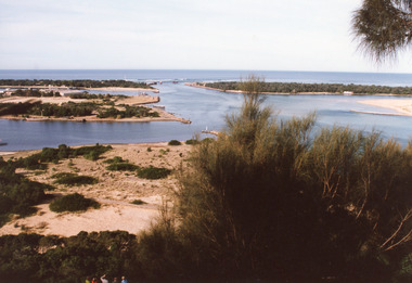 Lakes Entrance Historical Society
Photograph - The Entrance, 1995c
Second colour copy as 01601-1 portrait size 15 x 10Colour photograph of the entrance from Bass Strait to the Gippsland Lakes. It shows buildings on Bullock Island including Peck's factory. Western end of Bullock Island and area below Jemmys Point, both made during dredging operations over many years. Two fishing boats in entrance. Lakes Entrance Victoria room display, waterways, topography -
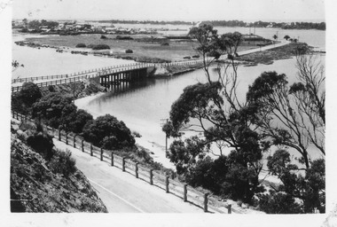 Lakes Entrance Historical Society
Postcard - Lakes Entrance, Bulmer, H D, 1940c
One Black and White Photograph 6.5 x 11|Two Postcard 8.5 x 14|Two Small format postcard 6 x 9|This is the before paired photograph used in the 150 year, Lakes Entrance 1858-2008 display.|The after paired photograph number is 01156.1 Also one 12 x 16 framed photograph used in room display.Black and white photographic of bridge over North Arm showing the western end of township, sand hummock viewed in distance, Lakes Entrance Victoriatownship, bridges, room display -
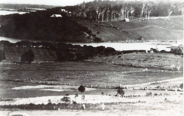 Lakes Entrance Historical Society
Photograph - Butcher's Paddock, 1935c
Copied from postcard in possession of Mrs Vera BennettBlack and white photograph of cleared land on each side of the North Arm, showing white ring barked trees in front of dense bush on western side, cleared and fenced paddocks on eastern side. Lakes Entrance VictoriaPanorama scene at Seaview Tearooms - Lakes Entrancetownship, waterways -
 Warrnambool and District Historical Society Inc.
Leisure object - Sheet Music, My Grampian Rose, 1940s
... lived in western Victoria. It has Ruby Wharrie’s signature ...This is a waltz piece of music with words and music by Ruby Wharrie. Mrs Wharrie is best known for her doll-making business which she operated in Stawell, Victoria with her husband and son. Mrs Wharrie was the designer of the dolls which were made in the 1940s and 50s. One doll was named ‘Shurl’ to cash in on the popularity of the child actress Shirley Temple and the consequent popularity of the Shirley Temple doll. Stawell is a provincial city situated close to the Grampians mountain range and the title of the music reflects Mrs Wharrie’s interest in the area. ‘My Grampian rose’ is a person and the theme of the music is the fulfilment of love - ‘I am coming back to you, my little Grampian Rose’. This music is of interest as it has been written by a person who lived in western Victoria. It has Ruby Wharrie’s signature inside the front cover, making it more valuable. It is also an example of the sweet and sentimental music produced during the 1940s and 50s as a foil to the sadness and brutality of the world war. This is sheet music of four pages (two pages printed back to back) with the printed music on three pages and the cover having a multi-coloured illustration of the Grampians mountain range in Victoria. It is in good condition and has an old catalogue number ‘94’ on the back page. Front cover: ‘My Grampian Rose, Words and Music by Ruby Wharrie, 2/6’ Inside front cover: ‘Ruby Wharrie’ ruby wharrie, my grampian rose, sheet music -
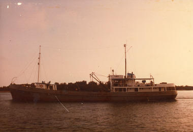 Lakes Entrance Historical Society
Photograph - Cowrie Bay, 1980c
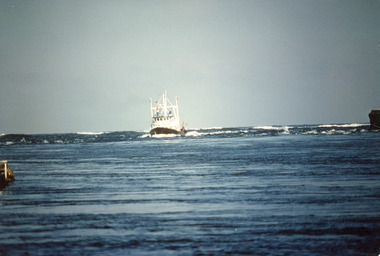
Skipper John Britton, Scott Hobson?, thought to be in mud in Tamar River, Tasm 2011Colour photograph of fishing boat Cowrie Bay which appears to be just outside Cunninghame Arm, the western side of the entrance and hummocks in background. Lakes Entrance Victoriafishing industry, ships and shipping, waterways -
 Lakes Entrance Historical Society
Photograph - James Merlin, Fraser, Ian, 1989c
Colour photograph of the fishing vessel James Kerlin entering the lake from Bass Strait. On right of image is the end of western pier, behind James Kerlin surf is breaking on bar, in foreground calm entrance channel. Lakes Entrance Victoriafishing industry, ships and shipping, waterways -
 Lakes Entrance Historical Society
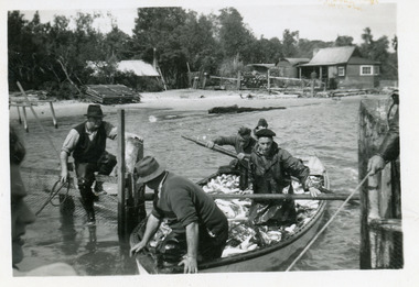
Photograph, 1947c
Also black and white enlargement 11.5 x 16Black and white small format photograph of fishermen at the fish pens in lake at Western Side of entrance. Four men in rowing boat loaded with fish, one man on fence, another holding rope to steady boat. Fishermen's cottages in background. Lakes Entrance Victoriafishing industry, boats and boating, waterways, occupation, fish -
 Lakes Entrance Historical Society
Photograph - The Entrance, Fish, Marie, 1995c
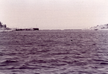
Black and white photograph showing view of entrance with eastern and western concrete and rock piers. Photo taken from boat in the channel. Waves breaking on bar at the entrance, at Lakes Entrance, Victoriaon back - The Entrance - taken from works boat, 1995 topography, waterways, piers -
 Lakes Entrance Historical Society
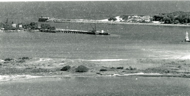
Photograph - New Works, 1920c
Black and white photograph showing entrance view from western pier towards eastern pier and works buildings, includes flagstaff rocket shed, township in distance, tramline along western pier in foreground, at Lakes Entrance, Victoria.Cunninghame Ocean Beachwaterways, piers, historic buildings -
 Lakes Entrance Historical Society
Photograph - Western Pier, 1922
... , wooden Western Pier in background small sailing boat in entrance ...Black and white photograph showing man made entrance from ocean into Gippsland Lakes, wooden Western Pier in background small sailing boat in entrance, whirlpools indicate tide on the turn. Lakes Entrance Victoriaboats and boating, waterways, jetties -
 Lakes Entrance Historical Society
Photograph, 1920c
Black and white photograph showing man made entrance from ocean to Gippsland Lakes, north end of western Pier on left, north end of Eastern Pier on right view looking from entrance towards Kalimna. Lakes Entrance Victoria waterways, piers -
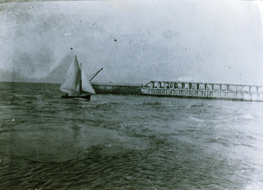
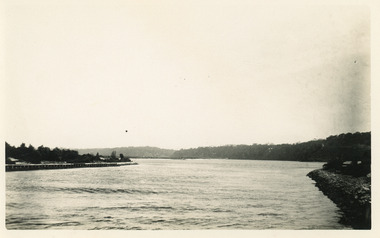
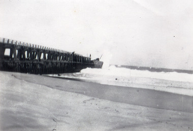
 Lakes Entrance Historical Society
Photograph - Western Pier
... foreground. Lakes Entrance Victoria Photograph Western Pier ...Also one black and white copy 9 x 15Sepia photograph showing wooden Western pier at entrance from ocean into the Gippsland Lakes, with dunes in background foreground shows top ridge of roof of rocket shed on left and shipwreck bell on far right foreground. Lakes Entrance Victoriawaterways, piers -
 Lakes Entrance Historical Society
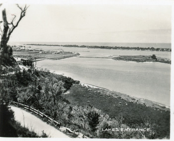
Photograph - The Entrance
photograph showing entrance from ocean - Bass Strait into Gippsland Lakes , western pier on left side shows timber structure , tramline and crane . North end of eastern pier on right shows workshed and travelling crane and rubble wall. Mt Barkley in background Lakes Entrance Victoriawaterways, boats and boating, piers, topography -
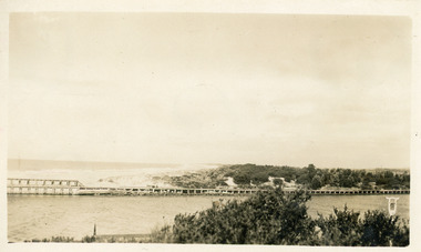
 Lakes Entrance Historical Society
Photograph - Western Pier, 1910c
... west of pier, at Lakes Entrance, Victoria. Photograph Western ...Black and white photograph showing wooden western pier with new concrete extension on seaward end and crane. Two men on top of pier, ocean breaking on beach west of pier, at Lakes Entrance, Victoria.waterways, machinery, piers -
 Lakes Entrance Historical Society
Photograph - The Entrance, 1920c
Black and white photograph showing entrance to Gippsland Lakes from ocean - Bass Strait. Photo shows rebuilt western pier with crane on end of pier, loose rocks. Launch - possibly Peels 'Blackbird' in the entrance. Lakes Entrance Victoria boats and boating, tourism, waterways, piers -
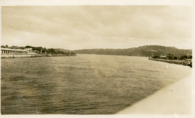
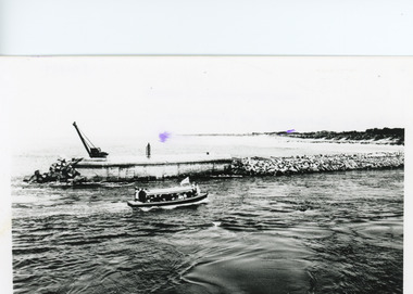
 Lakes Entrance Historical Society
Photograph - The Entrance, 1920c
Copied from photograph in possession of J WhadcoatBlack and white photograph showing stone piers at entrance to Gippsland Lakes from ocean - Bass Strait. Eastern pier on left, dune and western pier on right. Cranes and some work sheds on left. Navigation light on tip of Bullock Island on extreme right. Lakes Entrance Victoriajetties, waterways, topography, township