Showing 123983 items
matching main-road
-
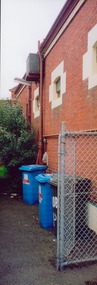 Kew Historical Society Inc
Photograph - Former Kew Post Office : Exterior wall, 1996
A civic campaign for new public offices developed in Kew in the 1880s. After much deliberation, the location chosen was the junction of Bulleen and Cotham Roads. The buildings were designed by George Watson and John Henry Harvey, architects within the Department of Public Works (Victoria). Building was commenced in 1887, and after one year, the buildings were opened. The Post Office was transferred to the new Commonwealth Government in 1901. The Police Station and Court House, sold by the Victorian Government to the City of Boroondara in 2007, are now a community cultural centre and performing arts venue.The buildings were listed on the Victorian Heritage Register Register (HO885) in 1991. They are historically and architecturally significant to the State of Victoria because Watson and Harvey's designs exhibit diversity in integrating civil offices, they accommodate the apex of road junctions, and they demonstrate a departure from the contemporaneously favoured High Victorian Classical to the Queen Anne style in the design of civic buildings.Side wall, facing Cotham Road of the former Kew Post Officekew court house, public offices -- kew (vic), kew police station, kew post office -
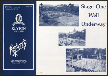 Ruyton Girls' School
Newsletter, Ruyton Reports, 1988
The Ruyton Reporter (formerly known as Ruyton Reports) captures the essential Ruyton Girls' School experience for the broader school community. It has been produced since 1986.The record has strong historic significance as it pertains to one of the oldest girls' school in Victoria, Australia. Ruyton was founded in 1878 in the Bulleen Road, Kew, home of newly widowed Mrs Charlotte Anderson (now High Street South). Thus, the record can be used as a reference example for research into Victorian school history. It also gives insight into the types of activities and events undertaken at Ruyton Girls' School during the period of its production. The record's significance is further enhanced by its exceptionally well-documented provenance, having remained the property of Ruyton Girls' School since its production.Black and white newsletter printed on paper with staple binding. 8 pages.Front Page: Vol. 3 No. 1 / Vol. 3 No. 1 April, 1988 / Registered by Australia Post / Publication No. VBH8187 / R / RECTE ET FIDE LITER / RUYTON / 1878 - 1988 Reports / From Ruyton Girls' School / 12 Selbourne Road, Kew. 3101 / Telephone (03) 819 2422 / Stage One / Well / Underway / S2/7 /ruyton girls' school, ruyton, school, students, newsletter, ruyton reports, ruyton news, kew, victoria, melbourne, girls school -
 Glen Eira Historical Society
Document - St. Georges Road, 68, Elsternwick
Two documents about the history and features of this property. A typed report about the ownership and occupancy from 1906 to 1978 of 68 St. Georges Road dated 21/07/1987 researched by Hailary Bullock and Rosalind Landells with handwritten working notes. Two evaluations, one for the house dated 05/05/1954, and one for the furnishings inside the house.st. georges road, george road, elsternwick, frederick sargood estate, sargood f., ripponlea, ring c., wrigley leslie j., belle vue, young stephen, locksley, cutts herbert, robertson david, robertson ada, edwards joseph, cording william, rybajzen jeko szaul, bullock hilary, landells rosalind, brighton historical society, architectural features, houses, land values, furnishings, brick houses, verandahs, cast iron work, edwards mrs -
 Glen Eira Historical Society
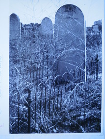
Document - Brighton Cemetery, North Road, Caulfield South
Print document, dated 15/02/2004, about a boating accident at Lake Tyers on 29/12/1921, in which Alexander Finlay of Kumalong in Kooyong Road, and Darrell Ray died. They were later buried at Brighton Cemetery. Includes references. A photograph (248mm x 150mm) of the grave of Samuel Masters, taken by John Bergin, date unknown.brighton cemetery, finlay alexander kennedy, finlay eileen, moroney eileen, kooyong road, ray darrell dysart mackintosh, caulfield south, kumalong, brighton general cemetery, masters samuel -
Glen Eira Historical Society
Document - Cambria
This folder contains one document about the owners of this property: The page provides a list of the tenants of Cambria, Neerim Road from 1891 to 1940. Sourced from Sands and McDougall. Also, Caulfield Rate Book Listings for the period 1889 to 1897. The document also provides a brief biography of George Davis with a reference to the Biography of Victorian Parliament. Handwritten, unattributed and undated.cambria, neerim road, davis george, davis george mrs, davies george, davis j h, deans walter , widdes john, widdes e a mrs, ellis richard, godby c t, presentation covent and ladies college, roseberry avenue, caulfield -
Glen Eira Historical Society
Map - Caulfield Fire Station, No 26, Tree Reserve, Dandenong Road
A one page photocopy of an undated, unattributed, hand drawn map (200mm x 290mm) of the location on Tree Reserve, Dandenong Road, of the Caulfield Fire station, No 26. The map includes handwritten notes showing various nearby property owners. The file also includes a photocopy of a one page, undated and unattributed printout of the site address and site lease date.caulfield east, caulfield fire station, dandenong road, derby road, racecourse road, tree reserve, shire of caulfield, federal bank, st james building society, delves murchison, fire stations -
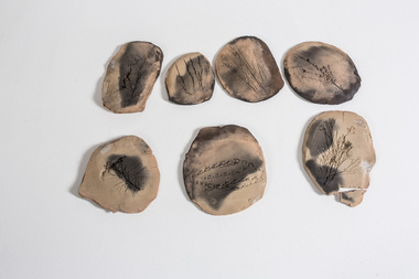 Nillumbik Shire Council
Clay: Leanne Mooney, Leanne Mooney, Tiles from the Boomerang Studio, 2002
'Tiles from the Boomerang Studio' is a prototype of the work 'Year 2052', created while Mooney was an Artist in Resident at Laughing Waters in the Boomerang studio in 2002. Records of flora were collected in and around the Gordon Ford garden in Laughing Waters Road. The work 'Year 2052' is made up of '77' tiles and was acquired by Geelong (Regional) Art Gallery in 2003. Whilst working at the Boomerang studio, local based artist Mooney noticed that “a battle raged in the bush between non-indigenous plants and indigenous plants”. She also noticed how humans “invade” land, changing the surrounding environment and causing irreversible damage. This work is an interpretation of the fragility and value of Nillumbik’s indigenous flora and of its conflict with introduced species. The title of the work (Year 2052) and look of these ‘fossilised specimens’ asks viewers to cast themselves into the future and to look back at today. “These tiles have been found; an incomplete record of flora collected in and around the Gordon Ford garden in Laughing Waters Road. The tiles appear to have been made at the beginning of the millennium. The viewer is asked to contemplate which species are missing”. Mooney works with collected indigenous items to emphasis the beauty of their natural shapes, while at the same time introducing selected materials of contrast or sympathy. Her work creates a great sense of “stillness and peace, of simplicity and connection with the natural world as well at the vanishing Australian bush.”This work is made up of seven handbuilt earthenware oval/round clay 'tiles' - (eight pieces - with one tile intentionally broken), brown in colour and bisque and blackware fired, giving a matt black ash coating on each of the tiles' surface. Each tile has an imprint of a floral specimen indigenous to the Laughing Waters area in Eltham. Each tile has an imprint of the following specimens: tiles, earthenware, flora, indigenous, bisque, boomerang, ford, laughing waters -
 City of Whittlesea
Badge - Badges - Advocacy Campaign, Access Denied, 2014
Access Denied was a joint advocacy campaign between the City of Whittlesea and the local community in the lead up to the 2014 Victorian State Election. The campaign called on all political parties to commit to extending the railway line from South Morang to Mernda and building access ramps on the Hume Freeway at O’Herns Road in Epping North. The campaign was a success and secured almost $650 million in promises from the incoming Labor Government to build these projects. Badge, metal back with pin, white plastic printed front, black and red textConnect O'Herns Road / Access Denied / Get on Board / www.accessdenied.net.au / Build Mernda Railbadges, campaign badges, south morang railway, mernda railway -
 Melbourne Tram Museum
Photograph - Black and White Coburg Horse Tram - Sydney Road at Warren's Corner
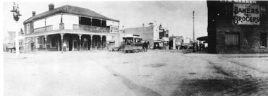
Photograph shows a horse tram in Sydney Road, Bell Street at Warren's Corner. This tramline was operated by the Northern Tramway Co. from 1889 to 1915 when it was closed and the line electrified by the Melbourne Brunswick and Coburg Tramways Trust to build their lines. See the reference for an extensive history of this horse tram line and the second reference for the City of Moreland about the history of this location. On the right hand side of the photo is "C & H Warren Bakers & Grocers" The Hotel on the corner is currently (2022), Browns Corner Hotel.Yields information about the Coburg horse tram and the streetscape. Black and White photograph of a horse tram in Sydney Road, Coburg at Warren's Corner.northern tramway co, horse trams, coburg, sydney road, trams, tramways, warren baker grocer -
 Mont De Lancey
Glass ashtray, Asahi Breweries
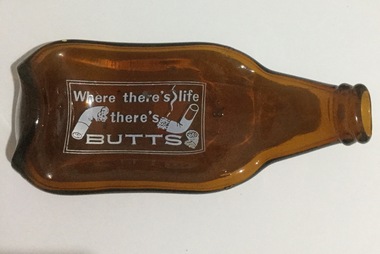
Asahi Breweries is one of the main operating companies of Asahi Group Holdings, Ltd. which is a beer and soft drink company based in Tokyo, Japan. As of January 2014, Asahi, with a 38% market share, was the largest of the four major beer producers in Japan. Amber-coloured glass ashtray created from a melted and squashed "stubbie" beer bottle with no cap.On main part of ashtray:"Where there's life there's butts" together with three cigarette butts, all surrounded by a double lined border, all in white paint. Around the base of the neck of the bottle: "Asahi Beer' embossed 4 timessmoking equipment, ashtrays -
 Orbost & District Historical Society
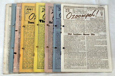
newsletters, F. Edward Edsall, Ozoompah, Dec. 1976 -21 Mar. 1979
These newsletters belonged to the Orbost Municipal Band. The Orbost Workers' Band and the Orbost Town Band amalgamated in 1913 to form the Orbost Municipal Band under the conductorship of Mr Charles Spink. The Orbost Municipal Band played a major role in the Orbost community activities. Charles Spink made sure each soldier returning home from the 1914 to 1918 war was welcomed home in front of the Shire Hall to the music of the Orbost Municipal Band. The band played in the main street on most Friday nights and in 1929 the band played at the official opening of the Buchan Caves, by Sir Albert Lind.The various Orbost bands over the years played a major role in community activities providing entertainment and musical experiences for the many members.Eight newsletters titled "Ozoompah for amateur banding in Australia"orbost-municipal-band newsletters-ozoompah -
 Rutherglen Historical Society
Image, c1990
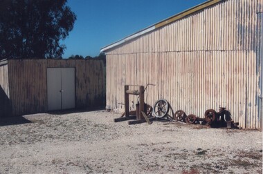
This photograph is of the back end of the side of the main building of the Gold Battery with workshop at rear (now demolished). Beside building is a hand windlass, along with some old pulleys and various parts. This is one of a series of photographs of the Rutherglen Gold Battery. The battery's purpose was to crush quartz from nearby quartz reefs and extract gold from within. The battery was erected in 1908 and consists of a five-head battery, Wilfrey table, Bergin pan, portable steam engine and shed. The battery was restored in 2011/12 and can be viewed daily between 9.00am and 5.00pm. See website for details.Colour photograph of the side of a corrugated iron building with a smaller building at the left, and a number of pieces of machinery next to the buildinggold battery, gold processing -
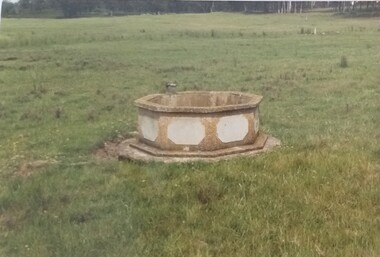 Tatura Irrigation & Wartime Camps Museum
Photograph, Arthur Knee, Camp 13 Decorative pond, 1989
Camp 13, Camp Road, Murchison. Water trough made by POW's. Cream concrete with white octagonal shapes on each side.Camp 13, Camp Road, Murchison, Victoria. Octagonal decorative concrete water trough, in green paddock. Cream concrete with white octagonal shapes on each side. -
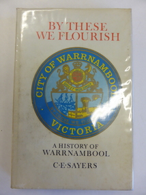 Warrnambool and District Historical Society Inc.
Book, By These We Flourish
This book is a first edition of the Warrnambool Council-sponsored official history of Warrnambool. It was written by the professional historian, C.E. Sayers. He had access at the time to the notes, photographs, radio talks and other writings of the former WarrnamboolTown Clerk and noted historian, Henri Worland.This book is of great importance as the chief comprehensive historical work published about Warrnambool since Vidler’s ‘Warrnambool Past and Present’ published in 1907. Even though a second edition of this book was published in 1987 this edition is still very important as it contains several photographs and some textual references not included in the later book. This edition is therefore still useful today and copies of it are not easy to find now. This is a hard cover book of 190 pages. The cover has a photograph in sepia tones of men road-making, with the same photograph back and front. The book has a plastic cover. This has a cream background with red and black lettering and a coloured image of the Warrnambool City Council crest on the front. An early map of the Warrnambool township has been reproduced on the inside of the cover, back and front. The book has a foreword, an introduction, 21 chapters of text, notes and appendices. by these we flourish, history of warrnambool -
 Stawell Historical Society Inc
Photograph, Salvation Army Group -- 4 Photos
Salvation Army. Four small photos. Two showing brass band march down Main Street Stawell. A bandsman in a bus labelled F. Green. Brunswick. Fourth photo of a Group lined up beside bus.Four small black & white photos on white card. Two showing brass band marching along Main St. Stawell. Third photo showing three bandsmen in a bus and one on top. name on the bus F.J. Green. Brunswick. The fourth photo shows a group of Salvation Army people lined up beside a larger bus. Name on bus sign is not decipherable. F.J. Green. Grunswick.stawell religion -
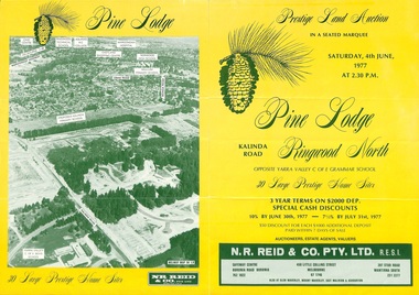 Ringwood and District Historical Society
Flyer, Land Auction Sale Brochure, Pine Lodge, Ringwood North, Victoria - 1977
Refer also to Reg. No. 5172 for Pine Lodge Land Auction 3rd release, 1978.Yellow double-sided real estate auction notice with green print showing aerial photograph and map of subdivision layout and summary of local features and services for Pine Lodge, Kalinda Road, Ringwood North. Auction date, Saturday, 4th June, 1977, at 2:30pm.Subdivision plan includes Parkgate Drive, Wood-Church Close, and Pensby Court. (Agent) N.R. Reid & Co. Pty. Ltd., Safeway Centre, Boronia Road, Boronia (Phone) 762 1022, 450 Little Collins Street, Melbourne (Phone) 67 1746, and 207 Stud Road, Wantirna South (Phone) 231 2277. -
 Mt Dandenong & District Historical Society Inc.
Photograph, The Valley of the Harmony Vale Settlement c1910, 1973
Scene looking across the valley of Harmony Vale from Barbers Road. c1910. Photograph copied by John Lundy-Clarke in 1973. This photograph has a detailed inscription on the back handwritten by John Lundy-Clarke in 1974.The valley of the Harmony Vale settlement on the Olinda Creek from Barbers Road. "Shiloah" on far left centre. John William Richardson's home among trees left of centre. Homestead Harmony Vale above log yard (see below) and among orchard trees. Child Bros sawmill and log yard with logs among trees above flat cultivation right of centre. Bert Childs home beyond "Harmony Vale". Lucas' "Glenrivers" is in gully above main clearing centre top left. Frank Childs home among trees centre of picture. Taken about 1910 by Rose Series. Copied 1974 JLC.kalorama, harmony vale, olinda creek, barbers road, shiloah, sawmill, child, bert child, glenrivers -
 Greensborough Historical Society
Photograph - Digital image, Miss Flowers and Dorothy Brown, 1940c
Miss Flowers and Dorothy brown; facing Para Road with Main Road strip behind them. Photographs from the collection of Peter Blackbourn, a descendant of the Chapman Stock family. Annotations to photos by Peter Blackbourn.Digital copy of black and white photograph.peter blackbourn, flowers family, dorothy brown -
 Eltham District Historical Society Inc
Photograph, Tom Prior, Nearing Eltham, from Research, Vic., c.1905, c.1905
View looking south along the main road from Research to Eltham Part of a presentation, "Roads and Byways of the Shire of Eltham", by Russell Yeoman to the 12 September 1990 Society meeting. Slides shown inclyuded copies of old photos and recent images ranging from the suburban streets of Eltham and Montmorency to the mountain roads of Kinglake. In the byways category are views of some iof the Shire's bicycle paths including then recently completed sections of the Main Yarra Trail at Lower Plenty.This photo forms part of a collection of photographs gathered by the Shire of Eltham for their centenary project book,"Pioneers and Painters: 100 years of the Shire of Eltham" by Alan Marshall (1971). The collection of over 500 images is held in partnership between Eltham District Historical Society and Yarra Plenty Regional Library (Eltham Library) and is now formally known as the 'The Shire of Eltham Pioneers Photograph Collection.' It is significant in being the first community sourced collection representing the places and people of the Shire's first one hundred years. The Reynolds family were early settlers in Research. The Reynolds/ Prior collection of photographs were taken by Tom Prior, the maternal uncle of Ivy Reynolds, around 1900 and the 60 photos in the album give a fine overview of many of the landmarks of Research and Eltham over 100 years ago. lvy lived in the family home for many years at 106 Thompson Cres Research. Ivy's father, Ernst Richard Reynolds and grandfather, Richard Reynolds, lived at the same address. Ivy's father Richard worked for Mr. Trail on his property in Research. Reynolds Road is named after the family. Mr Tom Prior (wife Eva) worked at the Melbourne zoo. He was very innovative and made his own camera, using the black cloth hood to exclude the light. The photographs are a reminder of the rural nature of Research and Eltham and its rich heritage.Digital image (Neg missing)shire of eltham pioneers photograph collection, eltham, main road, research (vic.), reynolds prior collection -
 St Kilda Historical Society
Postcard, Wiltonia, Ormond Esplanade, Elwood
Photograph of ponies and children outside "Wintona" Ormond Esplanade, cnr Glen Huntley Road and Ormond Esp black and white photograph, unmounted, copy, fair conditionWritten on the back: Ben Taggart, Emma Taggart, John Taggart, Matilda Parker "Wintona" Ormond Esplanade, cnr Glen Huntley Road and Ormond Esp -
Whitehorse Historical Society Inc.
Article, Love began at Mitcham factory, 2005
Article about the 70th wedding anniversary of Pat and Gladys McClare who grew up in Mitcham.Article about the 70th wedding anniversary of Pat and Gladys McClare who grew up in Mitcham. McClare Road Vermont is named after Pat's grandfather who owned a tannery (Photo)Article about the 70th wedding anniversary of Pat and Gladys McClare who grew up in Mitcham. mcclare, pat, mcclare, gladys, mcclares road vermont -
Whitehorse Historical Society Inc.
Article, Carefree days last for decades, 2005
Article about the 70th wedding anniversary of Pat and Gladys McClare who grew up in Mitcham.Article about the 70th wedding anniversary of Pat and Gladys McClare who grew up in Mitcham. McClares Road Vermont is named after Pat's grandfather who owned a tannery (photo)Article about the 70th wedding anniversary of Pat and Gladys McClare who grew up in Mitcham.mcclare, pat, mcclare, gladys, mcclares road vermont -
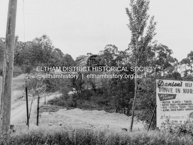 Eltham District Historical Society Inc
Photograph, Barry Philp, Eltham Barrel under construction, 1968
View from Main Road looking up at the Eltham Barrel under constrcutrion. Note sign for Danson's (nursery) Gardens.research (vic.), building construction, danson's gardens, eltham barrel -
![Newspaper Clipping, Diamond Valley Leader, Weyman & Jamieson, family law [1995], 13/09/1995](/media/collectors/4f729f5697f83e03086015b8/items/5be005c621ea6e174c7a2226/item-media/5be0068b21ea6e174c7ad6af/item-fit-380x285.jpg) Greensborough Historical Society
Greensborough Historical SocietyNewspaper Clipping, Diamond Valley Leader, Weyman & Jamieson, family law [1995], 13/09/1995
Advertisement in the local paper for Weyman & Jamieson, family lawyers, of 113 Main Street Greensborough and Plenty Road Bundoora [1995]Newspaper advertisement, black and white text and image.weyman and jamieson, main street greensborough, plenty road bundoora -
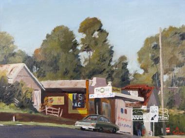 Eltham District Historical Society Inc
Photograph, Ted Dalton, The Corner Store, Ted Dalton, c.1980, 1980c
View of the old Burgoyne store looking south-east across Main Road, Eltham near the intersection with Bridge Street.Digital scan of painting c.1980 oil on board 44.5 x 59.5 cm signed lower rightburgoyne store, eltham, main road, ted dalton -
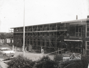 Eltham District Historical Society Inc
Photograph, Completing the south wing of Eltham Shire Offices for Library and Planning Departments, 1971, 1971
Completing the south wing of Eltham Shire Offices for Library and Planning Departments, Main road, Eltham. Building demolished 1990s.1 photographBack: "Shire Office extensions 1971" eltham, shire of eltham, eltham library, building, planning department -
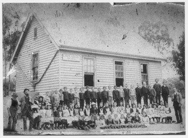 Ballarat Heritage Services
Photograph - Black and White, Yandoit Hill State School No. 691
The land for this school was donated by Carlo Gervasoni. When it closed it was moved to the corner of Main Road and Seventh Street, Hepburn Springs. Black and white photograph of three men standing either side of a number of school children of Yandoit Hill State School. yandoit, yandoit hills, yandoit creek, yandoit hill state school, gervasoni, hepburn springs -
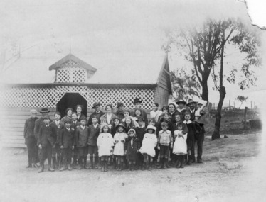 Ballarat Heritage Services
Photograph - Photograph - Black and White, Yandoit Hill State School No. 691, c1919, c1919
The land for this school was donated by Carlo Gervasoni. When it closed it was moved to the corner of Main Road and Seventh Street, Hepburn Springs.A number of adults, and students of Yandoit Hill State School, stand in front of the playground shed. One man is in an AIF uniform, and another has a slouch hat on. yandoit creek, yandoit hills, education -
Glen Eira Historical Society
Letter - Anderson, Irene
This file contains 3 stapled sleeves packaging to Irene Anderson’s research into the Langdon and Webb families (a photocopy of the Caulfield Historical Society minutes for 21/05/1980, Correspondence undated) with the secretary of the Society re a visit to the Langdon home and an annotated photocopy of an order by the Prahran Mechanics Institure for the Anderson book on the Langdon a note re a residents’ query about 523 Neerim Road.local history, langdon clive (mrs), genealogy, langdon, beaumaris beach road 411., anderson richard, anderson irene, prahran mechanics institute, anderson mary ann, glen eira historical society, neerim road 523, ballantyne, poath road, webb, eddie mary, halstead, 5th caulfield scout group, architectural features -
Glen Eira Historical Society
Letter - Centre Road, 229, Bentleigh
A two page typed copy of a letter dated 21/10/1966 to Mrs Thompson from valuer W V Scott containing a valuation of her property at 299 Centre Road, Bentleigh. It includes a detailed description of the land, room layouts and out buildings. Also includes two pages of undated, unattributed handwritten working notes relating to the valuation of the property.thompson mrs, centre road, bentleigh, whitmuir road, architectural features, garages