Showing 1557 items
matching e. s.
-
 Stawell Historical Society Inc
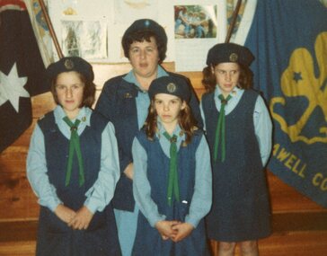
Photograph, Fifty two colour photographs of Girl Guides and Brownies
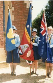
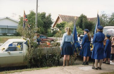
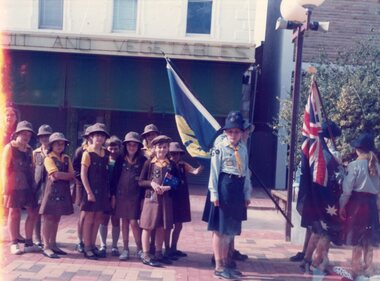
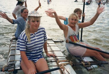
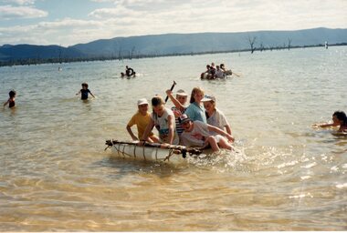
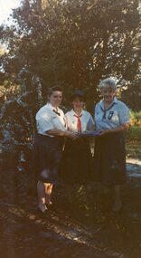
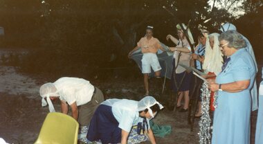
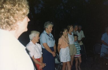
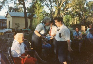
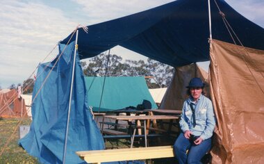
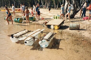
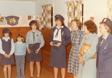
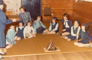
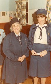
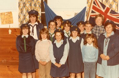
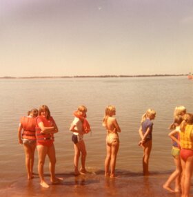
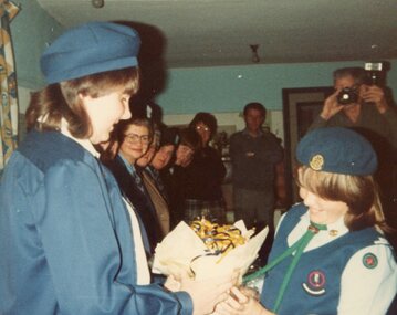
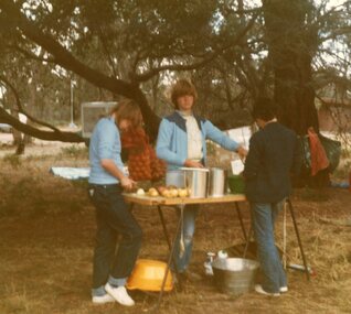
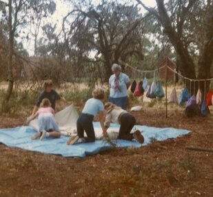
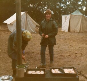
Girl Guides and Brownies photographs 7120 -1 Baston Park 1988 -2 Regional Commissioner Irene Beckley farewell at Bastin Park -3 State Commissioner Mrs Wooley Nov 19, 1980 Church Parade -4 Evening to Farwell Iris Bickley Bastin Park 1988. Regional Comm -5 June Radford at rear in White Jumper -7 Katrina Sweeney, Kylie Whelan, Kerrie Rosenow, Church Parade Nov 19th, 1988 -8 Anzac Day 1988 -9 Susan Hart, Joy Gilsenan, Katrina Sweeney, Marti Osborne, Kylie Whelan, Water Activities 1988 -10 Water Activities 1988 -11 Megan Croft, Viv Neville, Bastin Park 1988 -12 Farwell to Iris Bickley, Bastin Park 1988, Region Comm -13 Bastin Park 1988 -14 Bastin Park 1988 -15 Camping at Jamboree 1988, Kaye Osborne -16 Water Activities 1988 -19 Leader Heather Duxon -20 On Right Leader Francis Croft -21 Lake Bolac 1981. Water activities day. -22 16th June 1983, Junior Leader Julie Nunn -23 23rd to 25th March 1984 Bastin Park, Linda Grellet, Rhonda Bullock, Anne McPherson -24 23rd to 25th March 1984 Bastin Park, Heather Duxon, Helen O’Shea -25 23rd to 25th March 1984 Bastin Park, Bernadette Moloney, Tania Cumming -26 23rd to 25th March 1984 Bastin Park test camp, Bernadette Moloney, Tania Cumming, Chris Collins -27 Taree, Francis Croft, Anne Maree -28 23rd to 25th March 1984 Bastin Park, Heather Duxson, Helen O’Shea -29 Neville & Beth Nunn and 2 daughters -30 23rd to 25th March 1984 Bastin Park, Tania Cumming, Chris Collens Test Camp -31 50 years of guiding Stawell, 1978 -32 Camp Bunjil 1981, Bastin Park -33 Taken at Kenga when Camper Van came up, Trainers Mrs Pert, Mrs Croft, Stawell April 1979 -34 50 years of Guiding -35 Camp Bunjil 1981 Bastin Park, Jacquelin Smith, Sarah Moreton -36 Striking Camp Region Camp Bastin Park 1983 -38 Camp Bunjil 1981 Bastin Park, 2nd from left Sharon Rhodes 1st Stawell, 4th Kathy Healy 2nd Stawell -39 Anzac Day 1983 -40 Megan Croft and Taree Francis Croft, 7th July 1983 -41 Dallas Campbell & Taree Francis Croft, 7th July 1983 -42 Anne Maree Waterhouse & Taree Francis Croft, 17th July 1983 -43 Mrs Pert Taken at Kenya April 1979 -44 Thank you Card 19-7-1984 Mrs Croft Taree -46 Thank you Card from E Raggatt -48 Activities at Camp Bunjil Bastin Park 1981 -49 Camp Bunjil Bastin Park 1981 -50 Jacquilin Smith & Catheryn van Leeiogh (Pack Guides 1978) Brownie Levels -51 Camp Bunjil Bastin Park 1981, Brenda Donovan -52 Kanya Camp 1977 Circa 1980's colour photographs in plastic pocketsVarious inscriptions on back of photographs -
 Stawell Historical Society Inc
Photograph, Fifty two colour photographs of Girl Guides and Brownies
Girl Guides and Brownies photographs 7120 -1 Baston Park 1988 -2 Regional Commissioner Irene Beckley farewell at Bastin Park -3 State Commissioner Mrs Wooley Nov 19, 1980 Church Parade -4 Evening to Farwell Iris Bickley Bastin Park 1988. Regional Comm -5 June Radford at rear in White Jumper -7 Katrina Sweeney, Kylie Whelan, Kerrie Rosenow, Church Parade Nov 19th, 1988 -8 Anzac Day 1988 -9 Susan Hart, Joy Gilsenan, Katrina Sweeney, Marti Osborne, Kylie Whelan, Water Activities 1988 -10 Water Activities 1988 -11 Megan Croft, Viv Neville, Bastin Park 1988 -12 Farwell to Iris Bickley, Bastin Park 1988, Region Comm -13 Bastin Park 1988 -14 Bastin Park 1988 -15 Camping at Jamboree 1988, Kaye Osborne -16 Water Activities 1988 -19 Leader Heather Duxon -20 On Right Leader Francis Croft -21 Lake Bolac 1981. Water activities day. -22 16th June 1983, Junior Leader Julie Nunn -23 23rd to 25th March 1984 Bastin Park, Linda Grellet, Rhonda Bullock, Anne McPherson -24 23rd to 25th March 1984 Bastin Park, Heather Duxon, Helen O’Shea -25 23rd to 25th March 1984 Bastin Park, Bernadette Moloney, Tania Cumming -26 23rd to 25th March 1984 Bastin Park test camp, Bernadette Moloney, Tania Cumming, Chris Collins -27 Taree, Francis Croft, Anne Maree -28 23rd to 25th March 1984 Bastin Park, Heather Duxson, Helen O’Shea -29 Neville & Beth Nunn and 2 daughters -30 23rd to 25th March 1984 Bastin Park, Tania Cumming, Chris Collens Test Camp -31 50 years of guiding Stawell, 1978 -32 Camp Bunjil 1981, Bastin Park -33 Taken at Kenga when Camper Van came up, Trainers Mrs Pert, Mrs Croft, Stawell April 1979 -34 50 years of Guiding -35 Camp Bunjil 1981 Bastin Park, Jacquelin Smith, Sarah Moreton -36 Striking Camp Region Camp Bastin Park 1983 -38 Camp Bunjil 1981 Bastin Park, 2nd from left Sharon Rhodes 1st Stawell, 4th Kathy Healy 2nd Stawell -39 Anzac Day 1983 -40 Megan Croft and Taree Francis Croft, 7th July 1983 -41 Dallas Campbell & Taree Francis Croft, 7th July 1983 -42 Anne Maree Waterhouse & Taree Francis Croft, 17th July 1983 -43 Mrs Pert Taken at Kenya April 1979 -44 Thank you Card 19-7-1984 Mrs Croft Taree -46 Thank you Card from E Raggatt -48 Activities at Camp Bunjil Bastin Park 1981 -49 Camp Bunjil Bastin Park 1981 -50 Jacquilin Smith & Catheryn van Leeiogh (Pack Guides 1978) Brownie Levels -51 Camp Bunjil Bastin Park 1981, Brenda Donovan -52 Kanya Camp 1977 Circa 1980's colour photographs in plastic pocketsVarious inscriptions on back of photographs -
 Stawell Historical Society Inc
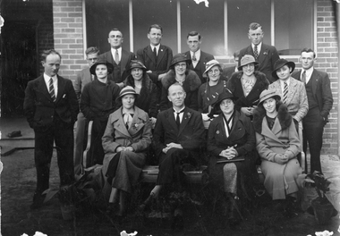
Photograph, Stawell Baptist Church Members c 1930's
Books on loan from Stawell Baptist Church.Copy of B/W photograph of men and women in front of brick building. 3 rows of peopleRow R L ?, Charlie Carter, Ray Kingston, A.?, TedNikkelson, Bob Blachford, Alex Bernhardt Shubert 2 Kyle Crossett, Gladys Crossett, Miss Edith G Dulcie Corrye, Florence Willy, Maisy Elliot 3 Daisy Kennedy, Rev N.S. Draper, Mrs Draper Dulcie Corrie & Berhardt Shubert. Married Florence E Willy & Ted Nikkelson Married at churcch 26/12/42 tr lo died Funeral service in Baptist church by Rev. Arlr B. Carter & Maisie Elliot Not Married.baptist church -
 Stawell Historical Society Inc
Photograph, Stawell Baptist Church Group
Stawell Baptist Church group c 1930's Back Row Charlie Carter, Ray Kingston, Alan Reeves, Ted Nikkelson, Bob Blachford, (hidden) Alex Robey, Ernhardt Schubert. Centre Row. Kyle Crossett, Gladys Crossett, Edith Gresswell, Dulcie Corrie, Florence Willy, Maisy Elliot, Phillis Morris, Front Row. Daisy Kennedy, Rev. N. s. Draper, Mrs. Draper, Win Lea. The original photograph belonged to Mr E. R. Nikkelson and taken at the time Rev. N.S. Draper was the minister. Black & White original photograph and copy of Stawell Baptist Church Group c 1930's stawell -
 Stawell Historical Society Inc
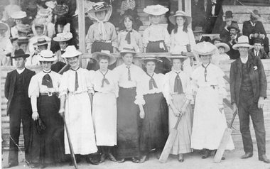
Photograph, Great Western Ladies Cricket Team 1907
Great Western Ladies Cricket Team 1907 Refer to. Stawell Times & Wimmera Advertiser 1907 March 15 Great Western Ladies Cricket Team M Smeaton, M Porter, L Fowler, L Wathen, C Fowler, H Nicholson, L Porter, L Farrell, G Smeaton. G Wathen, M Bullock. 1907 Dec 13 G & M Smeaton, S & M Porter, L & G Wathen, E Coates, E Glisson, E Goswinckle, E Delahoy, M Blanden.Group of Ladies in long dresses, white blouses and hats standing in front of a pavilion verandah. Man at each end, two ladies and a man holding Cricket bats. Original photo is a post cardLadies cricketers of Great Western season 1907stawell sport -
 Stawell Historical Society Inc
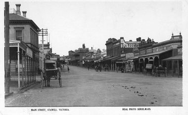
Photograph, Main Street Stawell looking East with the Post Office on left & the Post Office Hotel on the right
Main Street Stawell looking East. Post Office on left, double story building. Note Post Office Hotel Rowland's as previously E. J. Copley . Real Photo Series M 673 1922. Six horse drawn carts along the street and people moving around the shops. Also the telegraph poles in this photo have 4 cross timber beams on the previous photo they only had 3 cross timber beams. Sepia photo of Main Street, Stawell c 1920's. The street scene show the commercial businesses of the time with horse and carts being the main form of transport.Main Street, Stawell. Victoria. Real Phot Series. M.673. Printed on the back "Published by the Valentine & Sons Publishing Co. Ltd. Melbourne Sydney & Brisbane.stawell streetscape -
Stawell Historical Society Inc
Photograph, Stawell High School Softball Team 1959 -- Named
C Jones, S Fawkner, L Sinclair, L Hall, E McKay, Adele Brown vc, Mr Mountford Van Every captain, P Hemley, H PhillipsNine female Softball Players and Coach/Teacher posing with crossed Softball Bats and Ball.Stawell High School Softball Team 1959sport, education -
 Stawell Historical Society Inc
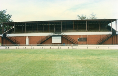
Photograph, Central Park Oval -- A E Neil Grandstand -- Coloured photograph c 2003
... . c 1980's Stawell sports A. E. (Hank) Neil Stand Colour photo ...A. E. (Hank) Neil Grandstand formerly known as No 2 Stand was restored and named after the long serving secretary of Stawell Athletic Club. He was also secretary of the Wimmera Football League. c 1980'sColour photo of A. E. Neil Grandstand formerly No 2 Grandstand. c 1980's. Photo located in album 3 page 71.A. E. (Hank) Neil Standstawell sports -
Malmsbury Historical Society
Photograph (Item), Old C Of E Sunday School, Malmsbury c1970
People - "Young, Betty" Buildings - "Malmsbury S/School, Drummond C Of E." Associated with - Anglican Church -
National Wool Museum
Book, Sheep production
"Sheep production" - R V Diggins and C E Bundy 1958. Directed towards sheep production in the U S A.sheep - american sheep stations - management sheep breeding farming, sheep - american, sheep stations - management, sheep breeding, farming -
 National Wool Museum
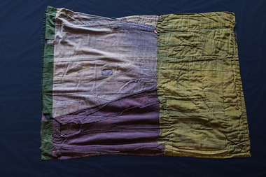
Textile - Quilt, Mrs Adolphina Noll, Wilmington Wagga, 1934
Made by Adolphina Noll in 1934 in Wilmington, South Australia as a wedding gift for Mr Joe and Mrs Ida (aka 'Ike') Fulwood. Mrs Noll was Ike's maternal grandmother and was 69 when she made the quilt. (It was used on a bed in a plain heavy woven calico cover which was secured with safety pins. The cover is not in existence.) It was given to Lois Densham in Adeleide from Ike, who was a close friend of Lois' sister, Doreen Saunders.Double bed sized quilt cover insert made from several items of clothing: men's frock coat (possibly from the 1900's), another men's coat (date unknown), a woman's coat with a fur trim on the pockets (possibly from the 1930's) and a woman's dress or skirt (circa 1920-30's). The clothing pieces have been arranged in an apparent haphazard way to create a shape with straight edges and corners to fit neatly into a cover onto a bed. Lining materials are apparent on the back of the woman's skirt/dress pieces which may also show that this item of clothing was either taken apart or never finished. Orange cotton lining material is also evident on some pieces of the men's coat.handicrafts, quilting, running stitch group, running stitch collection, highlights of the national wool museum: from waggas to the wool quilt prize - exhibition (22/09/2001 - 02/12/2001), noll, mrs adolphina fulwood, mrs e. g.