Showing 3010 items matching " lane a."
-
 Kiewa Valley Historical Society
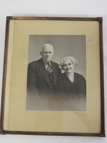
Photo Framed - Portrait of Walter and Ada Ryder, c 1930's
Portraits were taken professionally often on important occasions. As graziers from a prominent family in Redbank, Walter and Ada Ryder were well known and respected.Walter and Ada Ryder were pioneer high country graziers and cattlemen. Ada (nee Sullivan)'s family lived at Redbank. Their children were Walter, Victor, Beatrice, Vera, Lorna and Dorothy. Walter 1872 - 1954; Ada 1887 - 1983 Walter was a son of John and Annie Ryder - Walter's parents being one of the first settlers in the valley. According to Ada Ryder's notes and John Cooper's notes, Ryders were followed by Higginsons followed by Coopers in about 1867/8. Ropers held Mullindolingong Station/Mt Yorke Station, but had managers on the station before actually taking up residence about 1867/8. Whilst the Sullivans lived at Redbank (now known as Coral bank), the Ryders lived at Tawanga (correct spelling in those days) on Ryders Lane, Tawonga where John and Annie first built and lived; Walter and Ada then occupied the family home, followed by Vera Hore (nee Ryder) and the current owners Kevin and Rhonda Ryder.Black and white photo of an elderly man and woman both well dressed. Framed by cream cardboard 3.5 cm at sides and 5 cm top and bottom with a plain metal frame surrounding all sides with decorated corners. McPherson, Albury on front below righthand side of the photo.walter ryder; ada sullivan; cattle graziers; tawonga -
 Warrnambool and District Historical Society Inc.
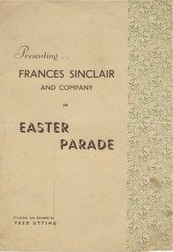
Document, Frances Sinclair Club Warrambool 1978, 1950s
This is the programme of a concert staged in Warrnambool in the 1950s. The production was put on by Frances Sinclair and Company and was presented and directed by Fred Utting. The performers included small children, mainly girls, ballerinas and an orchestra. Frances Sinclair also had a shop in Liebig Street in the 1950s called the Olympic Sportswear.This programme is of interest because it is an example of the type of entertainment provided in Warrnambool in the 1950s with the performers from a local company teaching dance and movement to young local people. The donor of the programme, Lyn Wright, was herself one of the ‘Tiny Tots’ performers. The donor of the programme was Alan Lane, a bus company proprietor in Warrnambool and a well-known businessman and supporter of the arts in the city. This is a sheet of paper folded in two to make four pages. The paper has been folded so as to make the first page of a smaller width than the second and third pages. The program is buff-coloured with a decorative green border on the front and third pages. The programme printing is in brown type. The programme contains a list of participants in the concert and the 24 items in the concert. frances sinclair and company, alan lane, history of warrnambool, warrnambool -
 Warrnambool and District Historical Society Inc.
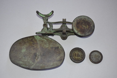
Scales, W. & T. Avery Ltd. Mill Lane Works, Nullawarre PO & tray + 2 weights, Early 20th century
These scales come from the Nullawarre Post Office and would have been used there for most of the 20th century. Nullawarre is a small settlement 25 kilometres south east of Warrnambool. It was first settled in the late 1860s and 70s and the main agricultural pursuit for the area today is dairying. The first Nullawarre school was opened in 1878 and the Nullawarre Post Office operates today in the Nullawarre General Store. These scales are of interest as a memento of the type of weighing scales used in Post Offices in Victoria in the early to mid 20th century. They are also of local interest as they come from the Nullawarre Post Office.This is a metal set of scales with a balance mechanism on a metal stand. The balance has a circular tray at one end to hold weights An oval dish to hold items to be weighed is a separate item that sits at the other end of the balance. The scales were once painted green and some traces of the green paint are visible. Two weights are with this item. The scales are much rusted. ‘W & T Avery Ltd Birm.’nullawarre, victoria, history of warrnambool -
 Eltham District Historical Society Inc
Photograph, Fay Bridge, EDHS Heritage Excursion, Culla Hill, Sweeneys Lane, Eltham, 7 September 2019
September Excursion - Culla Hill Walk Pioneer Eltham farmer Thomas Sweeney (1803 - 1867) named his house, “Culla Hill” after the area in Ireland that he came from. His house, now called “Sweeneys”, remains on a ridge line overlooking the Yarra River. It is recorded that Thomas Sweeney did well out of carting potatoes and other supplies to the various gold fields such as Bendigo, McIvor (Heathcote), Mount Alexander and Beechworth. Culla Hill is now the name of the road providing access to subdivided lots of the former Sweeney property. The Culla Hill walk will start at the corner of Kent Hughes and Lavender Park Roads, Eltham (Melway ref. 22 A9) at 2.00pm on Saturday 7th September. - EDHS Newsletter No. 247 August 20192019-09-07, activities, culla hill, eltham, eltham district historical society, fay bridge collection, heritage excursion, sweeneys lane -
 Eltham District Historical Society Inc
Negative - Photograph, Russell Yeoman, Bridge over Arthurs Creek, Chapel Lane, Nutfield, c.1970
Roll of 35mm black and white negative film, 4 of 7 strips and corresponding B&W printIlford HP4chapel lane, arthurs creek, nutfield, bridge -
 Eltham District Historical Society Inc
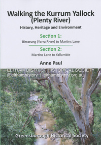
Book, Anne Paul, Walking the Kurrum Yallock (Plenty River), 25 July 2023
Kurrum Yallock - the Plenty River is Melbourne's third river. It is a defining feature of the region weaving its way through local suburbs and parklands. It is often hidden from general view, emerging at bridges and along its extensive trail network. While diminished since European settlement, the River provides an important environmental, wildlife corridor and recreational resource, along with many links to its settlement heritage. The Kurrum Yallock walks aim to guide people along the River Trail, while providing insight into key aspects of our recent history, an opportunity for reflection and an enhanced enjoyment of the River's special environment and landscape.birrarung, greensborough historical society, kurrum yallock, martins lane, plenty river, yallambie, yarra river -
 Eltham District Historical Society Inc
Photograph - Aerial Photograph, Landata, Eltham, Feb. 1956
Centred on present day Culla Hill and Petty's Orchard, Eltham bounded by Brougham Street and Mount Pleasant Road to north, Monckton Road, Templestowe to south, Reynolds Road to east and Eltham Lower Park and Hohnes Road to west. Historic Aerial Imagery Source: Landata.vic.gov.au Aerial Photo Details: Project No :250 Project : MELBOURNE OUTER SUBURBS PROJECT Run : 18 Frame : 92 Date : 02/1956 Film Type : B/W Camera : EAG9 Flying Height : 10000 Scale : 12000 Film Number : 1176 GDA2020 : 37°43'35"S, 145°09'31"E MGA2020 : 337735, 5822959 (55) Melways : 22 B8 (ed. 42)aerial photo, 1956-02, neil webster collection, eltham, brougham steet, culla hill, eltham lower park, hohnes road, melway 22b8, monckton road, mount pleasant road, petty's orchard, reynolds road, sweeneys lane, templestowe, yarra river -
 Eltham District Historical Society Inc
Photograph (Item) - Negative, Ed Stuyfbergen, St Laurence Lane, Eltham, 1988
Ed Stuyfbergen 1988 Entrant No. 26 Ref: Series 34, Items 13, 14, 66-68 The images in this record were not selected for inclusion. SHIRE OF ELTHAM COMMUNITY PHOTOGRAPHIC SURVEY Photography is an artform which many of us practice, sometimes purely for artistic pursuit, sometimes to record the people and events in our lives. In 1988, as part of a local Bicentennial project, the Shire of Eltham conducted the Eltham Community Photographic Survey. Up to 100 entries were to be selected by a panel of photographers for entry into the Eltham Photographic Survey Exhibition. Entries had to be submitted by May 13, 1988. Entrants whose images were selected for the exhibition were contacted and requested to further submit an entry form providing entrant’s name, area of residence, age, and proposed captions. These details were then used to produce labels for the exhibition mounts. Where negatives had not been supplied, these were requested to support the display of printed enlargements mounted on 10” x 8” cardboard. The mounted prints were made available post exhibition for sale at $8.50 each for colour prints and $7.00 for B&W prints. Residents in the Shire were invited to collect a free roll of film and take a photograph of what they either liked or did not like about the area. A total of 160 entrants submitted multiple entries for the exhibition. Of those selected for exhibition, entrants ranged in age from 9 to 70 years. All custom colour and black and white printing for the exhibition was completed by Wattle Studios of Eltham. The Eltham Photographic Survey was jointly auspiced by the Shire of Eltham and Wattle Studios, of 953 Main Road, Eltham. The project was greatly assisted by: • David McRitchie, Media Studies Lecturer Victoria College, Rusden Campus. • Ian and Annette Toohill of Wattle Studios • Tracy Naughton, Eltham Community Arts Officer • Neville Emerson Pty. Ltd. • Superior Press, Eltham • Kodak Australasia Pty. Ltd. • Agfa Gevaert Ltd. • Townsend Colourtech Pty. Ltd. • The Australian Bicentennial Authority • Eleanor Bowers, Secretary, Eltham Arts Council The exhibition was placed on display in the Woolworths Arcade, Eltham between Monday June 6th and Saturday June 11, 1988. It was also intended to hold the exhibition at a venue in the Shire’s North Riding from Monday, June 20 to Friday June 24. It was then displayed at the Were Street Theatre, Montmorency from Friday, June 24 to Thursday, July 7. Series 34: Eltham Community Photographic Survey 1988 - Prints & Documentation Series consists of 117 photographs of Shire scenes taken by members of the community. Items I - 41 are larger photographs mounted on card, which were exhibited. Items 42 - 117 are unmounted copies, alternative takes and other entries. Corresponding negatives contained in Series 35: Eltham Community Photographic Survey 1988 – Negatives which consists of 267 colour and B&W negatives and one colour slide of Shire scenes taken by members of the community. The negatives are arranged by the entrant number of the photographer. The Eltham Community Photographic Survey collection is significant to the local community as it was curated by the local community - ordinary people of all ages - representing what they liked and did not like in the area where they lived. It represents an unfiltered representation of the Shire of Eltham as it was in 1988. It also represents one of many projects as part of the national programme of events and celebrations to commemorate the bicentenary. It is a time capsule of life in the 1980s of this urban and rural municipality in Melbourne's north. shire of eltham archives, bicentennial project, eltham, eltham community photographic survey, series 35, ed stuyfbergen, film - ilford fp4, scan - 35mm negative, st laurence lane -
 Eltham District Historical Society Inc
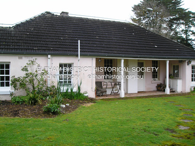
Photograph - Digital Photograph, Alan King, The barn at Culla Hill, Sweeneys Lane, Eltham, 30 January 2008
The barn of former convict Thomas Sweeney at Culla Hill remains almost in its original condition. Published: Nillumbik Now and Then / Marguerite Marshall 2008; photographs Alan King with Marguerite Marshall.; p19This collection of almost 130 photos about places and people within the Shire of Nillumbik, an urban and rural municipality in Melbourne's north, contributes to an understanding of the history of the Shire. Published in 2008 immediately prior to the Black Saturday bushfires of February 7, 2009, it documents sites that were impacted, and in some cases destroyed by the fires. It includes photographs taken especially for the publication, creating a unique time capsule representing the Shire in the early 21st century. It remains the most recent comprehenesive publication devoted to the Shire's history connecting local residents to the past. nillumbik now and then (marshall-king) collection, culla hill, eltham, sweeney's cottage, sweeneys lane -
 Eltham District Historical Society Inc
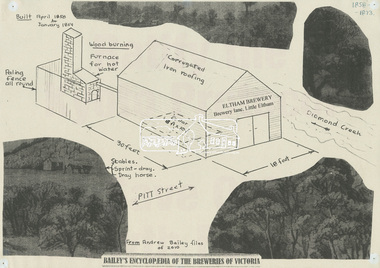
Document - Drawing, Harry Gilham, Schematic of Eltham Brewery, Brewery Lane, Little Eltham (1858-1873), c.2010
From Andrew Bailey files of 2010, this is a hybrid illustration by Harry Gilham of the Eltham Brewery 1858-1873. This item was created as a for illustrative purposes at Eltham District Historical Society displays eltham brewery, little eltham, display -
 Eltham District Historical Society Inc
Album - Photograph Album, J.A. McDonald, Bridge and Road Reconstruction Works, Shire of Eltham, 1952-1962
J.A. McDonald produced this record in the course of his responsibilities as Shire Engineer for Eltham Shire Council.Record of various Shire of Eltham infrastructure works undertaken during the period of 1952-1962 involving bridge and road reconstruction projects, sometimes with Eltham Shire Council Project Reference numbers quoted. It was during this period that a number of significant improvements were made to roads and new bridges constructed within the shire that remain in place as of present day (2022). In many situations, the photos provide a tangible visible record of infrastructure that existed throughout the early days of the Shire. The album was put together by or under the direction of the Shire Engineer, J.A. McDonald.a. gillies, alistair knox park, benchmark studies, bend of islands, blease road, box hill state school, box hill teachers college, box hill tip, bridge construction, bridge street bridge, bridge, brisbane street, brougham steet, bulldozer, cecil street, charis pelling, cherry tree road, city of preston, cr. a. brinkkotter, cr. charis pelling, cranes, cromwell street, diamond creek (creek), diamond street, dixons creek bridge, dixon's creek road, drott, eltham leisure centre, eltham north, eltham police station, eltham, eltham-yarra glen road, f. wood, fitzsimons lane bridge, flat rock road, flood damage, floods, floodwater, footpaths and gutters, ford service garage, g. blair, garden hill, glen park bridge, glenauburn road, grand hotel, haldane road, healesville, healesville-yarra glen road, heidelberg-kinglake road, henley road bridge, henley road, hill property, hurstbridge water scheme, hurstbridge, hurstbridge-arthurs creek road, infrastructure, j. jolly, kangaroo ground, kangaroo ground-queenstown road, kangaroo ground-st andrews road, lilydale shire office, long gully bridge, long gully creek, long gully road, long gully, lower plenty bridge, lower plenty footbridge, lower plenty oval, lower plenty road, lower plenty, main road, methodist church, montmorency, mount pleasant road, new holland, old healesville road, opening ceremony, oxley bridge, para road, paul creek bridge, paul creek road, paul krafeznk, pinnacle lane, plaques, plenty river trail, plenty river, presbyterian church, prof donald thomson, pryor street, railway crossing, railway parade, rattray road, reconstruction works, reichelt avenue, research (vic.), research oval, road construction, rymers corner, shire of eltham, shire of whittlesea, silvan road bridge, silver street bridge, silver street, sir dallas brooks, smedley property, st andrews, steels creek, susan street, tarrawarra, tony carberry, uniting church, upper yarra dam, upper yarra reservoir, w.e. wolf, waterfall property, watsons creek, wattletree road bridge, wattletree road, wattletree road bridge, worlingworth, yarra glen, york street, yow yow creek -
 Eltham District Historical Society Inc
Album - Photograph, J.A. McDonald, Eltham-Templestowe Road, c. 1957
Site for bridge over Yarra River looking from Eltham bank.Record of various Shire of Eltham infrastructure works undertaken during the period of 1952-1962 involving bridge and road reconstruction projects, sometimes with Eltham Shire Council Project Reference numbers quoted. It was during this period that a number of significant improvements were made to roads and new bridges constructed within the shire that remain in place as of present day (2022). In many situations, the photos provide a tangible visible record of infrastructure that existed throughout the early days of the Shire. The album was put together by or under the direction of the Shire Engineer, J.A. McDonald.infrastructure, road construction, shire of eltham, bridge construction, bridge street bridge, 1957, fitzsimons lane bridge, eltham-templestowe road -
 Eltham District Historical Society Inc
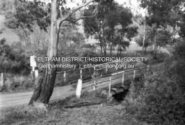
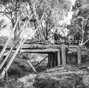
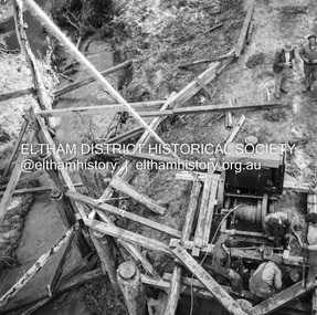
Negative - Photograph, J.A. McDonald, Pinnacle Lane, Steels Creek, Sep. 1955
The old bridge looking downstream Record of various Shire of Eltham infrastructure works undertaken during the period of 1952-1962 involving bridge and road reconstruction projects, sometimes with Eltham Shire Council Project Reference numbers quoted. It was during this period that a number of significant improvements were made to roads and new bridges constructed within the shire that remain in place as of present day (2022). In many situations, the photos provide a tangible visible record of infrastructure that existed throughout the early days of the Shire. The album was put together by or under the direction of the Shire Engineer, J.A. McDonald.1955-09, pinnacle lane, steels creek, bridge construction, infrastructure, shire of eltham -
 Eltham District Historical Society Inc
Negative - Photograph, J.A. McDonald, Pinnacle Lane, Steels Creek, Sep. 1955
The old bridge looking eastwardsRecord of various Shire of Eltham infrastructure works undertaken during the period of 1952-1962 involving bridge and road reconstruction projects, sometimes with Eltham Shire Council Project Reference numbers quoted. It was during this period that a number of significant improvements were made to roads and new bridges constructed within the shire that remain in place as of present day (2022). In many situations, the photos provide a tangible visible record of infrastructure that existed throughout the early days of the Shire. The album was put together by or under the direction of the Shire Engineer, J.A. McDonald.1955-09, pinnacle lane, steels creek, bridge construction, infrastructure, shire of eltham -
 Eltham District Historical Society Inc
Negative - Photograph, J.A. McDonald, Pinnacle Lane, Steels Creek, Sep. 1955
The old bridge from top of pile frameRecord of various Shire of Eltham infrastructure works undertaken during the period of 1952-1962 involving bridge and road reconstruction projects, sometimes with Eltham Shire Council Project Reference numbers quoted. It was during this period that a number of significant improvements were made to roads and new bridges constructed within the shire that remain in place as of present day (2022). In many situations, the photos provide a tangible visible record of infrastructure that existed throughout the early days of the Shire. The album was put together by or under the direction of the Shire Engineer, J.A. McDonald.1955-09, pinnacle lane, steels creek, bridge construction, infrastructure, shire of eltham -
 Glen Eira Historical Society
Document - Langdon Homes of Caulfield
One item encompassing three copies of this book: Two photocopies of the proof of the book The Langdon Homes of Caulfield by Irene Anderson published by Caulfield Historical Society in 1986. The book contains a history of the Langdon Family and their houses in Glen Eira: Rosecraddock, Lirrewa, Beemery, Hengar, Lincluden and Croton Hurst. Also one final print of this published book.the langdon homes of caulfield, caulfield historical society, rosecraddock, caulfield, langdon road, langdon philip, langdon marie, anderson irene, langdon henry joseph, hawthorn road, powderham road, kooyong road, craddock avenue, langdon elizabeth laetitia lane langdon, langdon montague william, roads board of caulfield, brighton cemetery, langdon edward henry, langdon charles petley, langdon john berry, langdon emily amy, langdon florence elizabeth, langdon laura, langdon blanche emma, beemery park, tarqua, renwick samuel, the garrell, glen eira road, seymour road, blanche street, lirrewa, renwick jane, read louise martha, freedman harold, langdon charles stanley blake, langdon richard read, langdon philip clark, langdon mary laetitia lane, langdon henry clive courtenay, elser lilian, st. mary’s church of england caulfield, keverell road, langdon richard berry, langdon charles hugh, topp mr., jamieson mr., tayler lloyd, mansions, balaclava road, crotonhurst avenue, langley h.t. rev., hengar, langdon henry, lirrewa grove, riddoch elizabeth helen, langdon leslie john, langdon mary elizabeth, langdon dorothy, langdon margery, caulfield town hall, caulfield shire council, caulfield city hall, lincluden, sinclair a.j., elsternwick, langdon madge, weddings, memorial services, beemery, beemery park estate, langdon clive, neringa, sadleir john, penleigh, garrell street, victorian style, croton hurst, webb george henry frederick, judges, langdon william farr, webb sophie sarah annie, webb dottie, mitchell road, caulfield racecourse, webb isabella, langdon frank henry webb, langdon george rupert webb, langdon mark, langdon webb, langdon isobel, langdon grace, langdon georgie, langdon violet, somers charles, mclaughlin j., walworth avenue -
Glen Eira Historical Society
Document - Lempriere Avenue, 10, St. Kilda East
A brief history of the property at 10 Lempriere Avenue, St. Kilda East, built on a subdivision of the land of William George Lempriere. Includes some information on the Lempriere Family and public park, Greenmeadows Gardens. The document by Rosalind Landells, David Bick and Hilary Bullock of the Brighton Historical Society is dated October 30, 1995. Includes handwritten notes covering mostly same information. Includes bibliography.greenmeadows, lempriere william george, clarke william senior, lempriere john thomson, zimmerman a.k., nelson frank l., greenmeadows gardens, lempriere avenue, nelson m.d., st. kilda east, parks and reserves, zucker a.a., greenmeadows lane, lempriere family, lempriere’s paddock, councillors -
 Eltham District Historical Society Inc
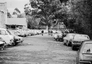
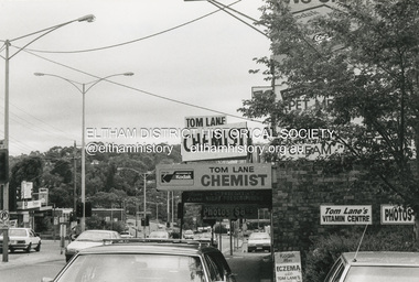
Photograph, Graeme Hardiman, Shopping Centre, Main Street, Greensborough, c.1988
greensborough, main street, shopping centre, tom lane chemist -
Eltham District Historical Society Inc
Document - Folder, Morrison: Sir William Irvine, Beatrice Wanliss Morrison
William Hill Irvine came from Northern Ireland around 1879 and lived in Heidelberg. He became a barrister and Member for Flinders Electorate, serving at various times as Attorney-General, Chief Justice, Premier and Lieutenant-Governor of Victoria. His daughter Beatrice married James Morrison and lived in Eltham. Irvine's other children were William and Agnes. William became Crown Prosecutor. Agnes married Ian Hayward and moved to Adelaide. Beatrice worked with the War Service Committee, raising money for the Red Cross and became chairman of the War Memorial Committee which built the Baby Health Centre, the Children's Library and the Pre-School Centre in Eltham. The family were interlinked with other local people. Contents Document by Beatrice W Morrison, 8 May no year given but pre 1989: life of Sir William Hill Irvine, his daughter Beatrice Wanliss Morrison and her husband James Morrison, and memories of Eltham and residents. Document summarising life of Beatrice Wanliss Morrison, undated but post 1989. Letter from Beatrice Williams to Eltham Shire, 29 September 1985: endorsing the idea of a nature corridor through Eltham Shire to the Great Dividing Range, noting she nursed the Morrison family before WWII. Letter from Health Shire to Beatrice Williams, 9 October 1985: acknowledging letter. Newspaper death notice, The Age, 19 March 2008: William Irvine Askin Morrison. Newspaper clippings, A4 photocopies, etcwilliam hill irvine, james morrison, agnes hayward nee morrison, war service committee eltham, red cross, baby health centre eltham, children's library eltham, pre-school centre eltham, somerville morrison, archie morrison, virginia morison, michael irvine, ian hayward, bill hayward, killeavy eltham, mccoll family eltham, logan family eltham, dry creek eltham, jack mccoll, burke and wills, orford family, andersons family, mount pleasant road eltham, reynolds road eltham, eddy anderson, reynolds family, sweeney family, sweeney's lane eltham, burston family, carrucan family, beatrice wanliss morrison nee irvine, beatrice williams, thomas watson haymes, william irvine askin morrison -
Eltham District Historical Society Inc
Document - Folder, Ness family
James Johnston settled at Kangaroo Ground in 1849. His nephew James Mess joined him and a descendant Robert James Mess changed his surname to Ness. The family became active in all aspects of Kangaroo Ground life. Contents Text (handwritten and transcribed): "The Ness Family, Kangaroo Ground", Joy Ness, 1989. Newspaper article: "True pioneer stock", Diamond Valley News, 2 March 1982. History of the Mess/Ness family Newspaper article: "Ness family are keepers of 140 years of historical knowledge", Diamond Valley News, 4 February 1986. History of Joseph Stephenson and descendants. Newspaper article: "Joy Ness paints native flowers for posterity". Diamond Valley News, 21 October 1986. Life and career of Joy Ness as painter. Newspaper article: "His Cup runneth of with Joy", ?Diamond Valley Leader, 6 December 2000. Bruce and Joy Ness celebrate 60th wedding anniversary. Pencil sketch by Joh Ebeli no date but pre 2004: Portrait of Joy Ness dressed for the Historical Society Parade. Order of Service: Thanksgiving service for the life of Robert Bruce Ness 22 January 1917 / 28 June 2004. Eltham District Historical Society newsletter no date: "Robert Bruce Ness 1917-2004", obituary and extract from Joy Ness's history of the family. Copy of letter from Joh Ebeli to Gwen Orford, no date but ~2004: Describes drawings he made of Robert Bruce Ness when taking part in Diamond Valley Arts Society float and enclosed 3 drawings and a photograph of drawing of the bakers (corner Main Road and York Street Eltham). Eltham District Historical Society newsletter September 2013: "Vale Joy Ness", obituary and extract from Diamond Valley News article of 6 December 2000.Newspaper clippings, A4 photocopies, etcness family kangaroo ground, james johnston, kangaroo ground, pretty hill farm, wellers hotel, betsy sadler, ingleside kangaroo ground, james mess, jane stevenson, ness lane kangaroo ground, view hill kangaroo ground, stte savings bank agency, ruth lettice gosling nee mess, kangaroo ground state school, garden hills kangaroo ground, william mess, joseph mess, isabella mess, james johnson mess, ruth ettie mess, george mess, alexander mess, janes mess, robert david mess, heidelberg agricultural show, diamond creek agricultural show, rober james ness, pearl ness nee mills, william mills, sabina mills, robert bruce ness, beryl ness, vera ness, donald ness, kangaroo ground presbyterian church, kangaroo ground cemetery trust, kangaroo ground tennis club, professor osborne, doctor osborne, joseph stevenson, joy ness, kangaroo ground fire brigade, bruce ness, country fire authority, ship wellington 1837, diamond creek, david christmas, christmas hills, andres harkness, samuel furphy, andrew ross, caledonian gold fields, queenstown now st andrews, mother coleman of kangaroo ground, diamond valley arts society, winifred joy ness, andrew ross museum, eltham art show -
Eltham District Historical Society Inc
Document - Folder, Reynolds, Ivy
Ivy Reynolds was born in Research in 1917, trained as a nurse and specialised as an Infant Welfare sister, later supporting many causes, receiving an Australia Day Award in 2005. Contents Typed notes: "Memories of Ivy Reynolds". Eulogy given by Jenny Anderson. Typed notes: "Vale Ivy Reynolds". Newspaper clippings, A4 photocopies, etcivy reynolds, ernest reynolds, research primary school, elsie reynolds nee prior, john reynolds, margaret reynolds, eltham high elementary school, dry creek research, mt pleasant road research, gum tree road research, reynolds road eltham, jenny disney, austin hospital, infant welfare centre research, john halfpenny, amnesty international, nursing mothers association, mission to streets and lanes, church missionary society, thompsons crescent research -
Glen Eira Historical Society
Article - Holy Cross Church, Glen Huntly Road, 705, Caulfield South
Two Holy Cross Musical Society Programs. Undated. Patience or Bunthorne’s Bride and The Mikado Article from Caulfield/ Port Phillip Leader 09/08/2011 Parish to Share Load Colour photo with article.holy cross church, freese christina, caulfield south, glen huntly road, rosenberger virginia, catholic church, programs, mckenny ross fr., holy cross advisory committee, southwick david mp lane colin -
 Eltham District Historical Society Inc
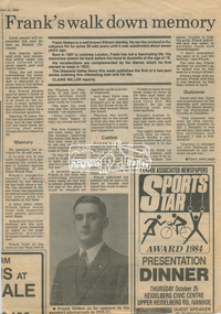
Newsclipping, Frank's walk down memory lane ... , Diamond Valley News, 11 September 1984, 11 Sep 1984
Digital file only - Digitised by EDHS from a scrapbook on loan from Beryl Bradbury (nee Stokes), daughter of Frank Stokes.beryl bradbury (nee stokes) collection, eltham, frank stokes, nyora road, stokes orchard -
 Eltham District Historical Society Inc
Slide - Photograph, Aerial Photo (c.1987): Main Road, Fitzsimons Lane, Lower Plenty, c.Aug. 1990
Part of a presentation, "Roads and Byways of the Shire of Eltham", by Russell Yeoman to the 12 September 1990 Society meeting. Slides shown included copies of old photos and recent images ranging from the suburban streets of Eltham and Montmorency to the mountain roads of Kinglake. In the byways category are views of some iof the Shire's bicycle paths including then recently completed sections of the Main Yarra Trail at Lower Plenty.35mm colour positive transparency (1 of 37) Mount - Agfachrome Agfa CS System black 8 dotsinfrastructure, roads, aerial photographs, roundabout, bolton steet, bolton steet shops, eltham, fitzsimons lane, lower plenty, main road -
 Eltham District Historical Society Inc
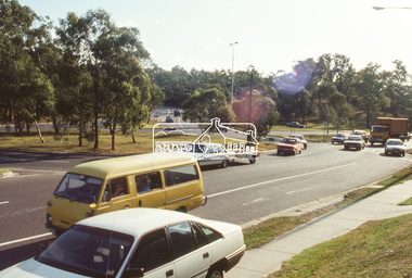
Photograph, Main Road Roundabout at Fitzsimons Lane, Eltham, c.Apr. 1988
35mm colour positive transparency (1 of 7) Mount - white plasticProcess Date APR Meltham, main road, roads, fitzsimons lane, infrastructure, roundabout -
 Eltham District Historical Society Inc
Photograph, Main Road Roundabout at Fitzsimons Lane, Eltham, c.Apr. 1988
35mm colour positive transparency (4 of 7) Mount - white plasticProcess Date APR Meltham, main road, roads, fitzsimons lane, infrastructure, roundabout -
 Eltham District Historical Society Inc
Slide - Photograph, Incident Control Centre, Kangaroo Ground, Ness Lane and Kangaroo Ground-St Andrews Road, c.May 1988
The Age, Saturday, April 15, 1989, Page 72 OPEN SAT SUN 2-4 WOODHAVEN ESTATE A sample of house and land packages for your consideration: 3 br Ige rumpus $159,950 4 br tri level $169.9S0 4 br split level $169,500 Colonial with verandahs $199,950 Big 4 br dble garage $235,000 Huge exec 5 br S266.000 Meet our representative on site 2-4pm Sat and Sun in Booth Court, Eltham. off Reynolds Rd. Melway ref 22.E.335mm colour positive transparency (1 of 23) Mount - Kodak EktachromeProcess Date MAY 88Mincident control centre, kangaroo ground, kangaroo ground-st andrews road, ness lane -
 Eltham District Historical Society Inc
Slide - Photograph, Dalton Street Lane, Eltham, c. Feb. 1989
35mm colour positive transparency (1 of 8) Mount - Agfa CS System grey 8 dotsdalton street, diamond creek trail, eltham -
 Eltham District Historical Society Inc
Slide - Photograph, Dalton Street Lane, Eltham, c.Mar. 1989
35mm colour positive transparency (1 of 28) Mount - Kodak KodachromeProcess Date MAR 89Meltham, dalton street, diamond creek trail -
 Eltham District Historical Society Inc
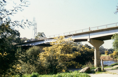
Slide - Photograph, Fitzsimons Lane Bridge, Templestowe, c.Sep. 1989
Part of a slide show presentation "Bridges & Waterways of the Shire" by Russell Yeoman to the 13 September 1989 Society meeting. The presentation included slides of historic photos from the Shire of Eltham Pioneers collections as well as several recent views.35mm colour positive transparency (1 of 33) Mount - Agfa CS System grey 8 dotsProcess Date Sep 1989fitzsimons lane bridge, templestowe