Showing 10966 items matching " plan"
-
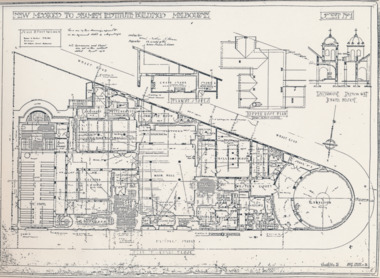
 Mission to Seafarers Victoria
Plan - Architectural drawings, Walter Butler, New Missions to Seamen Institute Buildings Melbourne, 1916
In August 1916, Walter R. Butler presented the plans for the future central Seamen's Institute.The drawings show the original plans with rooms' names and intended use. They also show the original concept for the chapel which was in the Spanish Mission style.Plan copied from the 1983 Howden and Wardrop A4 report. A large plan copy of the original is held in the MSTV archives.flinders street, mission to seamen, mission to seafarers, walter richmond butler (1864–1949), norla dome, st peter chapel, spanish mission, arts and crafts, 1916 -
 Kew Historical Society Inc
Plan - Subdivision : Cotham and Glenferrie Roads, J R Mathers & McMillan
The Kew Historical Society's map collection includes a substantial number of real estate subdivision plans, mainly of Kew but also of surrounding suburbs in Melbourne. Most of the subdivision plans date from the 1920s and 1930s when the districts old homes and local farmland were being split up to accommodate residential growth in the postwar period. These early plans were assembled by a local firm, Jas R Mather & McMillan, which had an office in Cotham Road. Many of the plans, and sometimes photos, were annotated by the agents.Subdivision plans are historically important documents used as evidence for the growth of suburbs in Australia. They frequently provide information about when the land was sold as well as evidence relating to surveyors and real estate and financial agents. The numerous subdivision plans in the Kew Historical Society's collection represent working documents, ranging from the initial sketches made in planning a subdivision to printed plans on which auctioneers or agents listed the prices for which individual lots were sold. In a number of cases, the reverse of a subdivision plan in the collection includes a photograph of a house that was also for sale by the agent. These photographs provide significant heritage information relating house design and decoration, fencing and household gardens.The photograph may also be aesthetically significant depending on the importance of the photographic atelier.An undated and untitled hand-drawn and coloured subdivision plan detailing the boundaries of a number of irregular allotments bordering Cotham Road, Glenferrie Road and Stirling Avenue (now Stirling Street). The plan predates the actual subdivision that led to the creation of the eight commercial properties occupying 118-132 Cotham Road. The plan may represent an old subdivision that was further subdivided at a later date, or it may be a subdivision that never eventuated. On MMBW Detail Plan 1575 (1903), the area represented by the proposed subdivision was residential rather than commercial. The irregularity of lots is also apparent in the MMBW Plan. The largest of the unnumbered blocks on the hand-drawn subdivision plan may relate to the boundaries of the nineteenth century mansion identified as ‘Kelso’ on the MMBW Plan.subdivision plans - kew, cotham road - kew,, glenferrie road - kew , stirling avenue street - kew -
 Warrnambool and District Historical Society Inc.
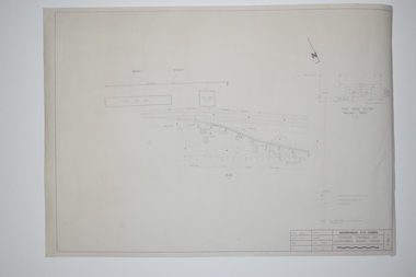
Documents, WCC Proposed turntable site railway station, 1968; 1989
These two plans are copies and show drawings for a proposed turntable at the Warrnambool Railway Station and railway crossings at Gilles Street in the Liebig Street precinct. The Warrnambool Railway was opened in 1890 and the Warrnambool Railway Station building was erected a few years later. These plans, being copies, are of minor interest as they show plans of some projects in the Warrnambool Railway Station precinct in the latter half of the 20th century.These are two sheets of cream-coloured paper with plans (copies of original) drawn up in black ink. The drawings are fading somewhat and are faint in places. One sheet (.2) has a piece missing from the top left hand corner. .1 ‘Locality Plan of Rail Crossings Liebig St. & Gillies (sic) St.’ .2 ‘Proposed Turntable Site Warrnambool Railway Station’ plans, warrnambool railway, warrnambool rail turntable -
 Bendigo Historical Society Inc.
Map - FRED COWIE COLLECTION: AERIAL MAPS OF HEATHCOTE/EPPALOCK, 28-9-1960
Map, Heathcote C2, Township of Heathcote, Melbourne Road through town branching off to Bendigo & Echuca. Aerial Survey of Victoria. Photo-map prepared by Department of Crown Lands and Survey from photographs taken in 1960. Copied photographically at the Central Plan Office.Fred Cowie,46 McIvor Rd,Bgo..Central Plan Officemap, heathcote, fred cowie -
 Creswick Campus Historical Collection - University of Melbourne
Document, unknown
School of Forestry existing services and condition plans, Building plans. Extension plansBuilding Plans -
Glenelg Shire Council Cultural Collection
Plan - Town Plan - Cape Bridgewater, 02/04/1992
Black and white photocopy of an old plan of a subdivision at Cape Bridgewater. Two halves joined together with sellotape. Black texta numbers on some of the lots 1 - 28Front: 'OLD MAP' handwritten, top edgeplan, town planning, cape bridgewater -
 Bendigo Historical Society Inc.
Map - FRED COWIE COLLECTION: AERIAL MAPS OF HEATHCOTE/EPPALOCK, 28-9-60
Map, Heathcote C4, Aerial Survey of Victoria,Photo-map prepared by Department of Crown Lands and Survey from photographs taken in 1960. Copied photographically at the Central Plan Office.Date 28-9-60,C.P.O.Neg.No.21590.Scale 4 inches to 1 mile. Fred Cowie,46 McIvor Rd,Bgo..Central Plan Office.map, heathcote, fred cowie -
 Friends of Ballarat Botanical Gardens History Group
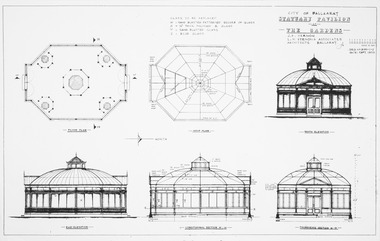
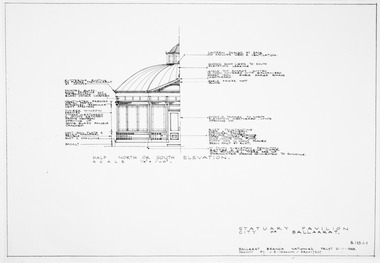
Plan, J.B Vernon et al, City of Ballaarat Statuary Pavilion at the Gardens, September 1970
Sections, elevations and floor plan for pavilionPhotocopyplan, drawings, statuary pavilion -
 Friends of Ballarat Botanical Gardens History Group
Plan, J.B Vernon et al, City of Ballaarat Statuary Pavilion at the Gardens - Part B, September 1970
Sections, elevations and floor plan for pavilionPhotocopyplan, drawings, statuary pavilion -
Lakes Entrance Historical Society
Plan - Diagram Plan of Survey at Mount Barkly Gipps Land Lakes
Plan of waterways, The Narrows, North Arm, Reeves River to the Entrance, Snake Island, Lancet Island, Rigby Island Southern OceanPlan of survey at Mount Barklywaterways, islands, ocean -
 Federation University Historical Collection
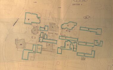
Plan - Site Plan, Mount Helen Campus Academic area
Federation University site plan made for the Ballarat College of Advanced Education Printed architectural plan of the Mount Helen campusprinted with location names and symbolssite plan, federation university, ballarat college of advanced education, mount helen campus, campus plan -
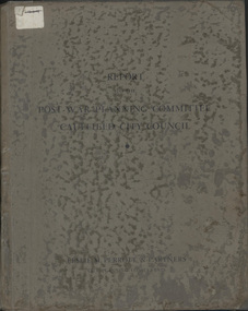 Glen Eira City Council History and Heritage Collection
Book, "Report to the Post War Planning Committee, Caulfield City Council"
The Post War Planning Report was prepared by Leslie M. Perrott & Partners: (City Planning Consultants) and according to the report, it was submitted to the Council of the Municipality of Caulfield through its Special Committee on Post War Planning. The report has no evident date however the introduction text suggests that it was prepared before the end of World War II. The report is the only known extant copy and therefore considered rare. Bound report with grey cover titled: "Report to the Post War Planning Committee Caulfield City Council". Interior pages include x83 pages typed text printed on blue print paper; x3 pages copies of black and white photographs; 10 blueprint plans. 86 pages consistent in size with book cover, 10 x blueprint plans varying dimensions, folded and bound within the report. Printed on white sticker on spine of book "LH 994. 51" and on first page inside "CAULFIELD LIBRARY SERVICE REFERENCE BOOK" and on the verso of this page, another stamp with CAULFIELD LIBRARY SERVICE and LH REF 12/7 hand written in black ink and a 14 digit reference number below this. On the back of the last plan in the book, there is a blue stamp with "REFERENCE BOOK TO BE USED IN THE LIBRARY ONLY". Below this is a black and white barcode with a black line through it and a round, blue sticker beside it. -
 Bendigo Historical Society Inc.
Map - FRED COWIE COLLECTION: AERIAL MAPS OF HEATHCOTE/EPPALOCK, 28-9-60
Map, Heathcote C3, Aerial Survey of Victoria, Photo-map prepared by Department of Crown Lands and Survey from photographs taken in 1960.Copied photographically at the Central Plan Office. Date 28-9 60, C.P.O.Neg. No.21588.Campaspe River, Coliban River. Flower Hill. Fred Cowie,46 McIvor Rd.Bendigo (Not located 29.9.2022)Central Plan Office.map, heathcote, fred cowie -
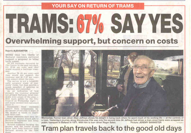 Ballarat Tramway Museum
Newspaper, The Courier Ballarat, "Trams: 67% Say Yes", "Put tram plan to the vote", "Lets make sure we all get on the right tram", "Trams would be bad for mall: manager", 13/07/2002 12:00:00 AM
Set of four cuttings from The Courier, Ballarat dated Saturday 13/7/2002 regarding the reintroduction of trams to Ballarat. 2239.1 - Front page with caption "Trams: 67% Say Yes", written by Alex Easton regarding a survey of 312 residents by the Courier. Also has a photo by Jeremy Bannister of former tram driver Alan Jeffreys at the controls of a tram in Wendouree Parade with Roger Salen in the background. 2239.2 - page 9 - Editorial written by Stuart Howie titled "Lets make sure we all get on the right tram" discussing the positive and negative attributes and problems of spending a large amount of money to return trams to Ballarat. Has a digitally composed photo of No. 13 in Lydiard St. North, showing destination "CITY" and a photo of the Eureka Stockade. 2239.3 - Page 4 - lead article titled "Trams would be bad for mall: manager", written by Alex Easton quoting David Nolan and the impact of trams on the mall, along with a cartoon about a tram ticketing machine being out of order. Cartoon by inkcinct. Also continues from page 1, lead article. Notes that readers can have they say on a web poll. 2239.4 - Page 8 - Letter to the Editor, by William J Hoath titled "Put tram plan to the vote", asking for any tram proposal to be put to the vote of ratepayers. Also on the side in a column titled "Short Takes", titled "Link lake to the tram line", provided by Joan C. Ryan of Ballarat.ballarat revival, letter to the editor, ballarat city tramway, lydiard st. nth -
 Mission to Seafarers Victoria
Plan - Architectural drawings, Walter Butler, New Missions to Seamen Institute Buildings Melbourne, 1916
In August 1916, Walter R. Butler presented the plans for the future central Seamen's Institute.The drawings show the original plans with rooms' names and intended use. They also show the original concept for the chapel which was in the Spanish Mission style.Plan copied from the 1983 Howden and Wardrop A4 report. A large plan on tracing paper (original or copy of the original) is held in the MSTV archives.flinders street, mission to seamen, mission to seafarers, walter richmond butler (1864–1949), norla dome, st peter chapel, spanish mission, arts and crafts, 1916 -
 Kew Historical Society Inc
Plan - Subdivision Plan, Argyle Road, Heather Grove, Victor Avenue, Kew, c.1937
The Kew Historical Society's map collection includes a substantial number of real estate subdivision plans, mainly of Kew but also of surrounding suburbs in Melbourne. Most of the subdivision plans date from the 1920s and 1930s when the districts old homes and local farmland were being split up to accommodate residential growth in the postwar period. These early plans were assembled by a local firm, Jas R Mather & McMillan, which had an office in Cotham Road. Many of the plans, and sometimes photos, were annotated by the agents.Subdivision plans are historically important documents used as evidence for the growth of suburbs in Australia. They frequently provide information about when the land was sold as well as evidence relating to surveyors and real estate and financial agents. The numerous subdivision plans in the Kew Historical Society's collection represent working documents, ranging from the initial sketches made in planning a subdivision to printed plans on which auctioneers or agents listed the prices for which individual lots were sold. In a number of cases, the reverse of a subdivision plan in the collection includes a photograph of a house that was also for sale by the agent. These photographs provide significant heritage information relating house design and decoration, fencing and household gardens.The photograph may also be aesthetically significant depending on the importance of the photographic atelier.Undated blue subdivision plan in Kew of 14 lots facing Argyle Road, Heather Grove and Victor Road. The Plan identifies Tuxen & Miller as the surveyors. [Formerly catalogued as MAP.0059]subdivision plans - kew, argyle road - kew, heather grove - kew, victor avenue - kew -
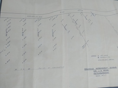 Peterborough History Group
Plan, Drainage Improvement Scheme. Mr J.S. Irvine. Peterborough
Assumed to be a plan of the drainage at The Lodge farmIndication of land levels c1970Professionally drawn plan of drainage scheme for J. S. Irvine.the lodge farm, drainage plan, j. s. irvine -
Port Melbourne Historical & Preservation Society
Plan - Proposed footbridge over the Lagoon, Bridge Street, Port Melbourne, 1863
Plan of proposed footbridge over the Lagoon in line of Bridge StreetIn ink on reverse, two small drawings: elevation land view over a distance of 25.00 chains (colour tinted), and Plan view, section of an unidentified street:In pencil on reverse, notation '107 Albert Street'sandridge lagoon, robert h morgan -
 Vision Australia
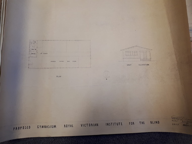
Plan - Image, Proposed Gymnasium Royal Victorian Institute for the Blind, 21 June 1950
In 1951 plans were made for the construction of a gymnasium to be situated in the grounds of St Kilda Road. These 4 plans specify the building construction notes, present front and east elevations, and show how part of the hall could be transformed into bedrooms in the future. There are 2 copies of each plan, consisting of identifical copies of the east elevation and different notes printed/handwritten on the front, side and top elevations. These were presented to the RVIB Board in Feburary 1951, according to the stamp on the back.2 architectural plans showing proposed gymnasium buildingPercy E Everett Chief Architectroyal victorian institute for the blind, plans -
 Ballarat Tramway Museum
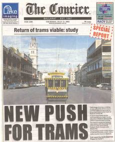
Newspaper, The Courier Ballarat, "Return of trams viable study", "New Push for Trams", "Taking tourism to the next level", "More tourists, more jobs expected", "Tram plan worthy of expected debate", 11/07/2002 12:00:00 AM
Set of three cuttings from The Courier, Ballarat dated Thursday 11/7/2002 regarding the reintroduction of trams to Ballarat. 2241.1 - Page 1 and 2 of The Courier, with page 1 titled "Return of trams viable study" and "New Push for Trams" as the commencement of a Special report showing a digitally constructed image of No. 13 in Lydiard St. North. Note the tram does not have a driver. Introduces reports by Alex Easton on pages 2, 6 and 7. On Page 2, titled "Taking tourism to the next level", has details of the Council viewpoints on the proposal, public consultation, a map of the route, and notes on the construction issues. Has a digital image of 13 crossing Sturt St. into Lydiard St. North. See images No. 1 to 3. 2241.2 - page 6 of The Courier, which joins with page 7 using the titled "More tourists, more jobs expected". Has Sections reviewing the study outcomes, benefits and a summary of the study. Page 6 has a photo of a passenger boarding No. 21, decorated as the Myers Christmas tram in Sturt St and a photo of Bridge St. in 1971 (very poor quality reproduction). See images No. 4 and 5. 2241.3 - page 7 of The Courier, has Sections detailing the history of Ballarat Trams, proposals for the City Tramway, costs, consultation, and comments from Peter Hiscock. Has a photo of Peter Hiscock and Mayor David Vendy in front of No. 13 at the BTM depot. See image No. 6. Also has a photo of Dianne Smith, Executive Director of Ballarat Tourism. On page 8, as part of The Courier's editorial Section, has comments on the proposals, titled "Tram plan worth of extended debate". Looks at the $20million cost. ballarat revival, editorial, ballarat city tramway, lydiard st. nth -
 Vision Australia
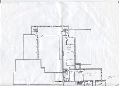
Plan - Image, 1920s and 1930s Room Allocation at RVIB, 1981-2004
Plans of the RVIB building in St Kilda Road, with handwritten annotations regarding their usage in the 1920s and 1930s. Recollections come from a discussion between David Ditchfield and Michele Prentice. Copy sent to Faye Woodhouse from Allom Lovell and Associates for the Conservation Management Plan.3 floor plans on A3 pages with handwritten notesAllom Lovell + Assocroyal victorian institute for the blind, plans, david ditchfield -
 Vision Australia
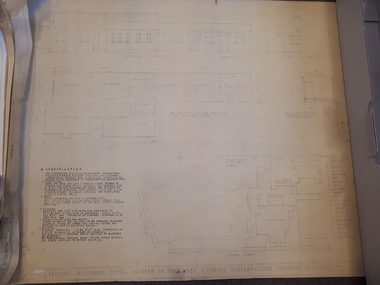
Plan - Image, Proposed additional nurses bedroom to "Myer Home" existing nursery, Blind Institute, St Kilda Rd, 23/8/1949
In 1949 an architect produced this plan to detail the addition of a bedroom for the nursing staff, who looked after children in the Blind Babies nursery. The plan shows a layout of the RVIB site, including the 'Myers Home' (the name of the nursery) where young children were cared for. The south and eastern elevations are detailed, as well as a plan of the nursery, which had 4 bedrooms, a living room, a dinning room , bathroom, 2 kitchen areas and the proposed additional nurses bedroom next to Bedroom 4.1 architectural plan of Myer House and proposed extensionPercy E Everett, Chief Architectroyal victorian institute for the blind, rvib nursery, plans, myer house -
Port Melbourne Historical & Preservation Society
Plan - Proposed Bayside development, Aug 1987
SCDC plans for the Bayside development were revised as investigations into water circulation in artifical canals/harbour were completed. This is the plan as originally proposed prior to the EES hearing in September 1987.Large plan of original proposed Bayside development as submitted to council in 1987town planning - proposals shelved - bayside, sandridge city development co pty ltd, scdc -
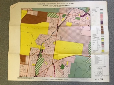 Greensborough Historical Society
Map, Melbourne and Metropolitan Board of Works Interim Development Order 1961 Map No. 53, 27/09/1961
Denotes Zones and Reservations comprising part of the municipalities of Eltham, Heidelberg, Preston and Whittlesea, approved 27.9.61. Includes Mont Park Hospital and Watsonia Military Camp.Colour plan Date printed on plan (1959) has been over stamped with 1961. Also stamped with Government Gazette date of 27.9.1961. "Scale 800 feet to 1 inch"greensborough, watsonia -
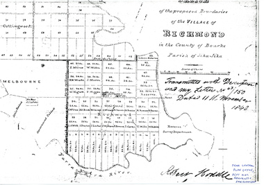 University of Melbourne, Burnley Campus Archives
Plan - Photocopy, Sketch of the Proposed Boundaries of the Village of Richmond, 1843
Sketch of the proposed boundaries of the village of Richmond in the County of Bourke Parish of Jika-Jika. Handwritten on original: "Transmitted with Description and my letter No 43/150 Dated 11th November 1843 Robert Hoddle." Shows Burnley Gardens site as "Reserve. Survey Department." original in Central Plan Office, Department of Natural Resources and EnvironmentIn ink: From Central Plan Office Dept. Nat. Resources & Environmentrichmond, jika-jika, survey department, yarra river, robert hoddle -
Port Melbourne Historical & Preservation Society
Plan, "State Bank of Victoria - Proposed dwelling Fishermans Bend"
Plans were brought to us for copying 19.05.2011 by CBA employee Steve Tserkezidis, who has access to old State Bank records. Borrowed for scanning by Gavin Rowson who put them on CD and returned 07.06.2011From series of State Bankhouse plans and elevations of types 1 - 8. A1 copies (.01) 1937 (stamp). (.02) 1928. (.03) 1937. (.04) 1937. (.05) no date. (.06) 1928. (.07) 1937. (.08) 1938. From plans accompanying bank House plans .01 to .08; (.09) MMBW plan showing bank properties (.10) Bank house plan: sections through walls. (.11) "Fishermans bend group" plan of properties (.12) Bank House plan of Pier Foundationgarden city, built environment - domestic, state savings bank of victoria, bank houses -
Ringwood and District Historical Society
Envelope, Jean Gordon Government Printer - Melbourne, Ringwood Primary School: Documents re Proposed school rooms, Canteen and Library plans, electrical plans. 1969-1973, 1969-1973
School PlansRingwood Primary School Documents:; 1969 Proposed school rooms - Plans.; No Date - Canteen Plans.; 1973 Library - Plans.; No Date - Electrical Plans. +Additional Keywords: Gordon, Jean -
 Ringwood and District Historical Society
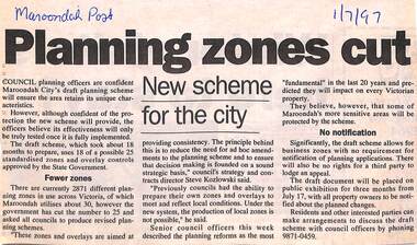
Newspaper, Scrapbook Clipping, Library Collection, Ringwood, Victoria
Newspaper Clipping from "The Maroondah Post", 1/7/1997. Planning zones cutCouncil planning officers are confident Maroondah City's draft planning scheme will ensure the area retains its unique characteristics. The council officers believe its effectiveness will only be truly tested once it is fully implemented. -
 Federation University Historical Collection
Plan, Ballarat School of MInes Allotments
-
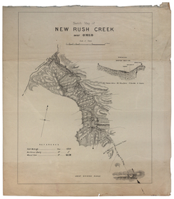 Federation University Historical Collection
Plan, New Rush Creek near Omeo
new rush creek, omeo, map, livingstone creek