Showing 2211 items
matching campaigning
-
 8th/13th Victorian Mounted Rifles Regimental Collection
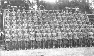
Photograph - 'C' Sqn 8LH 1915
Group photograph taken shortly prior to departure for overseas. The 8th Light Horse Regiment AIF was raised at Broadmeadows Victoria in September 1914 under the command of Lieutenant Colonel Alexander White and formed part of the 3rd Light Horse Brigade. The regiment served at Gallipoli where in a courageous but ill-fated charge at the Nek on 7 August 1915 it suffered horrendous casualties including Lieutenant Colonel White. Rebuilt in Egypt under the command of Lieutenant Colonel Leslie Maygar VC the regiment went on the serve throughout the Middle East Campaign. Colonel Maygar died of wounds at Beersheba when the regiment was attacked by enemy aircraft while waiting to follow up the successful charge of the 4th LH Brigade on 30 October 1917. The 8th Light Horse AIF was disbanded in 1919, but soon after re-raised as the 8th (Indi) Light Horse in the Citizen Military Forces, superseding 16th (Indi) Light Horse. It had its headquarters at Benalla with sub-units throughout the Upper Murray and Northeast Victoria. In December 1941, the regiment converted from horse to mechanised, initially as 8th Reconnaissance Battalion then in July 1942 it became 8th Cavalry Regiment and served in Northern Territory. As Japanese threat to the mainland declined the regiment was disbanded.Black and white photograph of C Squadron, 8th Australian Light Horse. Photo is mounted on backing card.'C. Squad. 8th Light Horse' and 'Darge Copyright'military, uniform, light horse, broadmeadows -
 8th/13th Victorian Mounted Rifles Regimental Collection
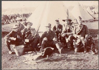
Photograph
Probably soldiers of 8th Light Horse Regiment The 8th Light Horse Regiment AIF was raised at Broadmeadows Victoria in September 1914 under the command of Lieutenant Colonel Alexander White and formed part of the 3rd Light Horse Brigade. The regiment served at Gallipoli where in a courageous but ill-fated charge at the Nek on 7 August 1915 it suffered horrendous casualties including Lieutenant Colonel White. Rebuilt in Egypt under the command of Lieutenant Colonel Leslie Maygar VC the regiment went on the serve throughout the Middle East Campaign. Colonel Maygar died of wounds at Beersheba when the regiment was attacked by enemy aircraft while waiting to follow up the successful charge of the 4th LH Brigade on 30 October 1917. The 8th Light Horse AIF was disbanded in 1919, but soon after re-raised as the 8th (Indi) Light Horse in the Citizen Military Forces, superseding 16th (Indi) Light Horse. It had its headquarters at Benalla with sub-units throughout the Upper Murray and Northeast Victoria. In December 1941, the regiment converted from horse to mechanised, initially as 8th Reconnaissance Battalion then in July 1942 it became 8th Cavalry Regiment and served in Northern Territory. As Japanese threat to the mainland declined the regiment was disbanded.Black and white photograph of 8 soldiers seated in front of a bell tent and horse lines at Broadmeadows Camp 1915. Soldiers have been drinking tea after cleaning saddles, set out before them. Some wearing slouch hats, one wearing forage cap. Photo mounted on card backing." T. Colquhoun Photo: Broadmeadows Camp 1915: 1 Donald street Prahran." -
 8th/13th Victorian Mounted Rifles Regimental Collection
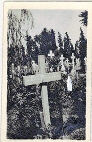
Photograph
Photographs taken by unknown photographer serving with 8th Light Horse Rregiment in Middle East 1916-1918.The 8th Light Horse Regiment AIF was raised at Broadmeadows Victoria in September 1914 under the command of Lieutenant Colonel Alexander White and formed part of the 3rd Light Horse Brigade. The regiment served at Gallipoli where in a courageous but ill-fated charge at the Nek on 7 August 1915 it suffered horrendous casualties including Lieutenant Colonel White. Rebuilt in Egypt under the command of Lieutenant Colonel Leslie Maygar VC the regiment went on the serve throughout the Middle East Campaign. Colonel Maygar died of wounds at Beersheba when the regiment was attacked by enemy aircraft while waiting to follow up the successful charge of the 4th LH Brigade on 30 October 1917. The 8th Light Horse AIF was disbanded in 1919, but soon after re-raised as the 8th (Indi) Light Horse in the Citizen Military Forces, superseding 16th (Indi) Light Horse. It had its headquarters at Benalla with sub-units throughout the Upper Murray and Northeast Victoria. In December 1941, the regiment converted from horse to mechanised, initially as 8th Reconnaissance Battalion then in July 1942 it became 8th Cavalry Regiment and served in Northern Territory. As Japanese threat to the mainland declined the regiment was disbanded.Two black and white photographs of crosses marking the graves of members of 8th Light Horse Regiment killed during WW! -
 8th/13th Victorian Mounted Rifles Regimental Collection
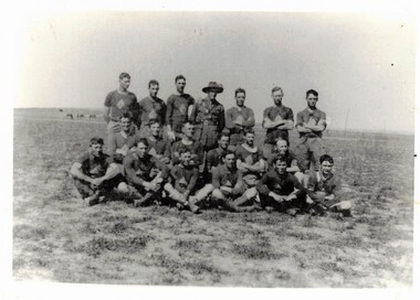
Photograph - Photograph of football team 8 ALH
Sport was encourage among troops while training or resting behind the lines. The 8th Light Horse Regiment AIF was raised at Broadmeadows Victoria in September 1914 under the command of Lieutenant Colonel Alexander White and formed part of the 3rd Light Horse Brigade. The regiment served at Gallipoli where in a courageous but ill-fated charge at the Nek on 7 August 1915 it suffered horrendous casualties including Lieutenant Colonel White. Rebuilt in Egypt under the command of Lieutenant Colonel Leslie Maygar VC the regiment went on the serve throughout the Middle East Campaign. Colonel Maygar died of wounds at Beersheba when the regiment was attacked by enemy aircraft while waiting to follow up the successful charge of the 4th LH Brigade on 30 October 1917. The 8th Light Horse AIF was disbanded in 1919, but soon after re-raised as the 8th (Indi) Light Horse in the Citizen Military Forces, superseding 16th (Indi) Light Horse. It had its headquarters at Benalla with sub-units throughout the Upper Murray and Northeast Victoria. In December 1941, the regiment converted from horse to mechanised, initially as 8th Reconnaissance Battalion then in July 1942 it became 8th Cavalry Regiment and served in Northern Territory. As Japanese threat to the mainland declined the regiment was disbanded.Rare photograph of football team in Middle East WWIBlack and White photograph of soldiers in football gear with one officer being AFL team of 8th Light Horse Regimentmilitary, football, 8 alh, world war one, wwi, middle east -
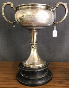 8th/13th Victorian Mounted Rifles Regimental Collection
Artwork, other - 8th LH trophy
Presented to the 8/13 Regimental Collection by the 8th Light Horse Association c. 1950. The 8th Light Horse Regiment AIF was raised at Broadmeadows Victoria in September 1914 under the command of Lieutenant Colonel Alexander White and formed part of the 3rd Light Horse Brigade. The regiment served at Gallipoli where in a courageous but ill-fated charge at the Nek on 7 August 1915 it suffered horrendous casualties including Lieutenant Colonel White. Rebuilt in Egypt under the command of Lieutenant Colonel Leslie Maygar VC the regiment went on the serve throughout the Middle East Campaign. Colonel Maygar died of wounds at Beersheba when the regiment was attacked by enemy aircraft while waiting to follow up the successful charge of the 4th LH Brigade on 30 October 1917. The 8th Light Horse AIF was disbanded in 1919, but soon after re-raised as the 8th (Indi) Light Horse in the Citizen Military Forces, superseding 16th (Indi) Light Horse. It had its headquarters at Benalla with sub-units throughout the Upper Murray and Northeast Victoria. In December 1941, the regiment converted from horse to mechanised, initially as 8th Reconnaissance Battalion then in July 1942 it became 8th Cavalry Regiment and served in Northern Territory. As Japanese threat to the mainland declined the regiment was disbanded.Silver Cup with handles presented to the 8th Light Horse Regiment for annual shooting competition. Cup sits on circular wooden base.8th Light Horse Regiment / The Wallace Cup / Teams match annual shootmilitary, light horse, 8th, wallace, trophy -
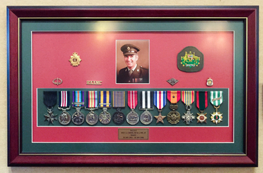 Tramways/East Melbourne RSL Sub Branch - RSL Victoria Listing id: 27511
Memorabilia - Medal Board, Ceremonial Medal Board for JJ Davis, 2001
John James Davis (J.J. Davis) was Australia's most decorated NCO in the Vietnam conflict. This plaque commemorates the deeds he performed and medals received.Framed ceremonial medal board for JJ Davis. The piece includes a service photograph of JJ Davis in uniform, a fabric patch with the Australian Coat of Arms, five metal pins and 13 replica medals as listed below. The information plaque states '5411313 WO1 J.J. DAVIS, SB St J, MM, JP - RAAMC - 30 JAN 1963 - 30 JAN 1986. The five metal pins are: 1. Returned Services League Australia 2. Returned Active Service 3. RAAMC 4. Royal Australian Army Medical Corps 5. Knife surrounded by laurel leaves. Replica medals included are: 1. Military Medal 2. Australian Active Service Medal 1945-75, Vietnam 3. Vietnam Medal 4. Defence Force Medal with 1st Clasp 5. National Medal 6. Australian Defence Medal 7. St John 12 Year Long Service Medal with five year clasp 8. Silver Star (Unites States of America) 9. Gallantry Cross with Bronze Star (South Vietnam) 10. The Armed Forces Honour Medal (2nd Class) (South Vietnam) 11. Civil Action Medal (2nd Class) (South Vietnam) 12. Vietnamese Campaign Medal 13. ACT Emergency Service Medal (2003 Bushfires) john jams davis, john james davis, j j davis, vietnam, nco, photographs, portraits, badges, medals -
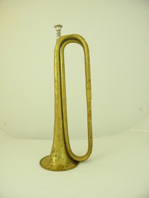 4th/19th Prince of Wales's Light Horse Regiment Unit History Room
Instrument - Trumpet, Cavalry, Couesnon Cie, 1901 (exact)
The 2nd Light Horse Regiment was raised at Enoggera in Queensland on 18 August 1914. Its recruits came mainly from Queensland but some hailed from the northern rivers district of New South Wales. The 2nd was one of three regiments of the 1st Light Horse Brigade – the first Australian mounted formation raised by Australia during the First World War. The regiment sailed from Brisbane on 25 September and disembarked in Egypt on 9 December. The 2nd Light Horse Regiment deployed to Gallipoli without its horses and landed there on 12 May 1915, joining the New Zealand and Australian Division. It played a defensive role for most of the campaign but did attack the Turkish trenches opposite Quinn’s Post, one of the most contested positions along the ANZAC Line. The first assault wave was mown down and fortunately the officer commanding the attack had the wisdom and courage to call it off. The 2nd was withdrawn from the front line in September and left the peninsula on 18 December. Back in Egypt, the 2nd Light Horse joined the ANZAC Mounted Division. Between January and May 1916, the regiment was deployed to protect the Nile valley from bands of pro-Turkish Senussi Arabs. On 18 May, as part of its parent brigade, it joined the forces defending the Suez Canal. The 1st Light Horse Brigade played a significant role in turning back the Turkish advance on the canal at the battle of Romani on 4 August. In ensuing days the regiments of the brigade participated in the immediate follow-up of the defeated Turks, but were soon withdrawn to rest. The 2nd Light Horse Regiment rejoined the Allied advance across the Sinai in November and was subsequently involved in the fighting to secure the Turkish outposts on the Palestine frontier – Maghdaba on 23 December 1916 and Rafa on 9 January 1917. A stint of protective duty along the line of communications through the Sinai followed. The 2nd’s next major engagement was the abortive second battle of Gaza on 19 April. Gaza finally fell on 7 November, after a wide outflanking move via Beersheba, in which the 1st Light Horse Brigade played a part. With the capture of Gaza, the Turkish position in southern Palestine collapsed. The 2nd Light Horse Regiment participated in the advance to Jaffa that followed, and was then committed to operations to clear and occupy the west bank of the Jordan River. It was involved in the Amman (24–27 February) and Es Salt (30 April–4 May) raids and the repulse of a major German and Turkish attack on 14 July 1918. The final British offensive of the campaign was launched along the Mediterranean coast on 19 September 1918, with the ANZAC Mounted Division taking part in a subsidiary effort east of the Jordan aimed at Amman. Turkey surrendered on 30 October 1918. The 2nd Light Horse Regiment sailed for Australia on 13 March 1919 without their horses, which were either shot or transferred to Indian cavalry units. Events in the daily routine of the soldier were signalled by bugle and trumpet calls. This trumpet is signicant because historically, it was issued to the 2nd Australian Light Horse Regiment in 1912. This Regiment served with distinction in Gallipoli and Palestine in World War 1. It is probable, but not confirmed, that tthe trumpet was used by the Regiment during these operations. Each light horse regiment was divided into four squadrons. Each squadron had a trumpeter sergeant, equipped with a cavalry trumpet, who was employed at the Squadron Headquarters Technically called a cavalry trumpet, this brass instrument can be described as a "simple trumpet" ie. the direct forerunner of the modern valve trumpet. It is in E flat not B flat as is the bugle. Both were carried slung over the player's body by means of green tasselled cords.Crest with inscription: "Exposition Universelle De Paris" with circular logo with inscribed "1900". "Hors Concours Membre De Jury". Logo formed of initials (not deciphered). "Couesnon Cie 94 Rue Dangouleme Paris". Bomb burst type logo with "01" in centre. "W H Paling & Co Ltd Sydney NSW Brisbane" On bell: "Mounted Rifles (2nd ALH)" trumpet, cavalry, musical instrument, 2nd light horse, mounted rifles -
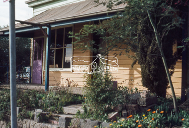
 Eltham District Historical Society Inc
Slide, Joh Ebeli, The old Baker's house prior to demolition, corner of York Street and Main Road, Eltham, c.Sep. 1979
Photo taken immediately prior to the demolition of the old baker's shop on the corner of Main Road and York Street, Eltham. Joh Ebeli and Elwers Howard endeavoured to preserve some parts of the house. The old weatherboard building, possibly dating from the 1860s, comprised a dwelling with a shop in the front room opening off a timber verandah deck which directly fronted the Main Road footpath. At the rear is a brick building of much later date which was for many years used for the bakery. The buildings were demolished for flat construction. Publicity at the time was oriented toward moves to preserve the weatherboard building which came from a number of individuals including members of this society. The society had no official connection with any proposal to retain the building or any part of it on any other site. The issues involved were part of a wider consideration of the matter of preservation of historic buildings. In this case the Society and in particular the committee had been aware for some years of the impending demolition. The possibility of the preservation of the building had been canvassed on a number of occasions. The Society’s view was that whilst the baker’s shop was an interesting old building which contributed to the character of Main Road, it was not of sufficient importance to wage an organised campaign for its preservation. It considered that if the building were to be preserved for historical reasons it would be far more feasible to retain it in its present location than to re-build it on another site.35 mm colour positive transparency Mount - Agfachrome Professional black (Germany) 4 dotsmain road, old eltham bakery, york street -
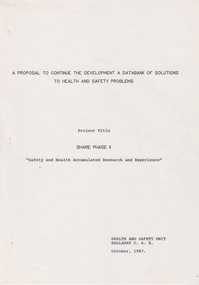 Federation University Historical Collection
Document - Document - Proposal, VIOSH: SHARE PHASE II; Safety and Health Accumulated Research and Experience, October 1987
Victorian Institute of Occupational Safety and Health (VIOSH) Australia is the Asia-Pacific centre for teaching and research in occupational health and safety (OHS) and is known as one of Australia's leaders on the field. VIOSH has a global reputation for its innovative approach within the field of OHS management. VIOSH had its first intake of students in 1979. At that time the Institution was known as the Ballarat College of Advanced Education. In 1990 it became known as Ballarat University College, then in 1994 as University of Ballarat. It was 2014 that it became Federation University. VIOSH Australia students are safety managers, senior advisors and experienced OHS professionals. They come from all over Australia and industry. Students are taught active research and enquiry; rather than textbook learning and a one-size fits all approach. VIOSH accepts people into the Graduate Diploma of Occupational Hazard Management who have no undergraduate degree - on the basis of extensive work experience and knowledge. Document is "A Proposal to Continue the Development of a Databank of Solutions to Health and Safety Problems". The project title is SHARE PHASE II "Safety and Health Accumulated Research and Experience". It was written by the Health and Safety Unit at Ballarat College of Advanced Education, 1987. The introduction of WorkCare and the promotional campaigns by the Department of Labour increased awareness and concern about the number of injuries and illnesses in the workplace. It became essential to provide information to employers, employees and inspectors on cost-effective solutions.Twenty-one page document, typed. Budget page with hand written comment, flowchart and timetableviosh, victorian institute of occupational safety and health, department of labour, workcare, databank, employers, employees, inspectors, health and safety unit, ballarat college of advanced education, share phase ii -
 4th/19th Prince of Wales's Light Horse Regiment Unit History Room
Medals, Africa Star, abt 1945
The Africa Star was granted for operational service in North Africa from the date of the entry of Italy into the war on 10 June 1940, up to the date of the cessation of operations against the enemy in North Africa on 12 May 1943. The Africa Star may also be awarded for operational service as a member of the Australian Defence Force during the Syrian Campaign in the period from 8 June 1941 to 11 July 1941. Eligibility This medal is awarded for a minimum of one days operational service in North Africa, west of the Suez Canal between 10 June 1940 and 12 May 1943 and in Syria between 8 June 1941 and 11 July 1941. The Medal The Africa Star is a six–pointed star of yellow copper zinc alloy. The obverse has a central design of the Royal and Imperial cypher, surmounted by a crown. The cypher is surrounded by a circlet containing the words ‘The Africa Star'. Stars issued to Australian personnel have recipient names engraved on the plain reverse. The Ribbon The Africa Star ribbon colours represent the desert and the service of the Armies, Naval Forces, Merchant Navy and the Air Forces. Clasps Three clasps were issued for the Africa Star: 8 th Army 1 st Army North Africa 1942-43 Only one clasp is worn and when the ribbon is worn alone a ribbon emblem, ‘8', ‘1' or silver rosette as appropriate is worn to denote the award of a clasp.Full size and miniature Africa Star medals. Miniature has clasps: North Africa 1942-43 8th Army 1st ArmyNo recipient engraved -
4th/19th Prince of Wales's Light Horse Regiment Unit History Room
Medal
Title Peace of 1919 medalet issued to Australian schoolchildren Object type Medalet Place made Australia: Victoria, Melbourne Date made 1919 Summary Designed by C Douglas Richardson, 'The Peace of 1919' medalet was issued by the Defence Department to school children throughout Australia to commemorate the signing of the Versailles Peace Treaty in 1919. The medals were originally suspended from a narrow piece of red, white and blue striped cotton ribbon. This medalet is associated with one of the children of Lance Corporal Giles Daniel, 1st AIF. Born in Ballarat, western Victoria on 16 December 1870, Giles Felix Daniel moved to Oakleigh, Victoria aged 15. A member of the Victorian permanent forces, he served as a corporal (regimental number 8) with the First Victorian Mounted Infantry Company, part of the first Victorian Contingent to the war in South Africa in 1899. This unit was one of the first Australian formations to see action during the Boer War. It was largely drawn from serving members of the Victorian forces. Demoted to private following a Court Martial on 19 November 1900, Daniel returned to Australia in December of the same year. During the First World War, he was again one of the first to enlist, joining the AIF on 19 August 1914, and becoming Lance Corporal number 32 with the First Divisional Signals Company. He served with this unit during the Gallipoli campaign and until his return to Australia on 11 April 1916. Silver-plated brass Circular medalet with a plain edge and integral suspension loop. The obverse features a symbolic female figure of Peace, holding a sword and standing on a plinth marked 'PEACE 1919'. Behind her flies a dove, and at her left and right feet are two figures freed from their shackles. The reverse features a central panel surrounded by laurel leaves, surmounted by the King's Crown with the word 'VICTORY' over the rays of the rising sun. A sailor and a digger stand at ease on either side of the panel on which is cast 'THE / TRIUMPH / OF / LIBERTY / AND / JUSTICE'. Below the leaves is a very small panel with the words 'THE PEACE OF 1919' and the manufacturer's name.peace medal 1919 -
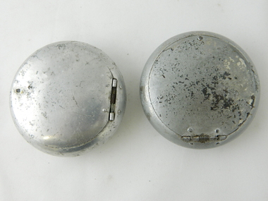 Kiewa Valley Historical Society
Ash Tray Pocket, Circa mid to late 1900s
This flip top pocket steel ash tray was at the beginning of the social "cleaning up" of cigarette ash and related products. This cigarette waste container was for those occasions when it was polite not to throw the cigarette ash and used up cigarettes "buts" on the ground, or if working in any rural area during a dry fire prone season, when discarding burning cigarette waste could set up a severe "bush" fire. It was also at the beginning of an intensive look at the affects of smoking upon the health of users. Later in the 1900s was a time when medical evidence supported a ground swell of the anti smoking movement which resulted in further restrictions of the use cigarette smoking in public places. Before the anti cigarette smoking revolution, it was both fashionable and manly to either roll your own cigarette or open up a packet of "tailor made's". In the rural and man's man environment the roll your own provided a visual acknowledgement that the user was "true blue" Aussie male and not a city boy. The cycle of use of cigarettes has drastically changed from when this item was first used. Today's society (post 2000) has produced a ground swell of government and non government organisations whose aim is provide a cigarette "ash" free environment and society. This is highlighted in the beginning of the 2000 millennium by a cigarette "Free" Australia campaign, and the pocket flip top personal ash tray as a practical solution for butt litter disposal.This pocket ash tray not only was used when social graces required it to, but also provided a container for any unfinished cigarettes or stogies (cheap half used cigars). In rural areas (open fresh air countryside), where time was always made available for the "smoko" (Australian rest period), at any time, especially after some hard physical work, the ability to have a self contained ashing apparatus, not to offend the gentler folk, was a pre-requisite . The rural environment, in the days of these cigarette ash containers,was one which could range from harsh and unforgiving to mild and relaxing. Smoking could be enjoyed anywhere and at any time without too much "fussing" around. This ash tray was mobile, convenient, unobtrusive and regarded by the user as being considerate to those around. It also eliminated the tell tale evidence that the "no smoking" signs had been ignored. The Kiewa Valley was like many rural ares that found it hard for smokers to come to grips with a governmental "non smoking policy" to indoor recreational and other "confined space" environments. Tin plated mild steel round container with a lid. The opening lid is spring loaded, hinged top, circular and fixed by a clasp, pop- riveted (4) onto the main housing. Opposite the hinge the lid is held closed by a small metal ball fitting tightly to the top wall of the container. The lid is opened by the use of a fingernail positioned at junction of lid to body. This edge is bevelled to allow access. personal effects, tobacco waste products, smoking accessories -
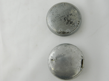 Kiewa Valley Historical Society
Ash Tray Pocket
This flip top pocket aluminium ash tray was at the beginning of the social "cleaning up" of cigarette ash and related products. This cigarette waste container was for those occasions when it was polite not to throw the cigarette ash and used up cigarettes "buts" on the ground, or if working in any rural area during a dry fire prone season, when discarding burning cigarette waste could set up a severe "bush" fire. It was also at the beginning of an intensive look at the affects of smoking upon the health of users. Later in the 1900s was a time when medical evidence supported a ground swell of the anti smoking movement which resulted in further restrictions of the use cigarette smoking in public places. Before the anti cigarette smoking revolution, it was both fashionable and manly to either roll your own cigarette or open up a packet of "tailor made's". In the rural and man's man environment the roll your own provided a visual acknowledgement that the user was "true blue" Aussie male and not a city boy. The cycle of use of cigarettes has drastically changed from when this item was first used. Today's society (post 2000) has produced a ground swell of government and non government organisations whose aim is provide a cigarette "ash" free environment and society. This is highlighted in the beginning of the 2000 millennium by a cigarette "Free" Australia campaign, and the pocket flip top personal ash tray as a practical solution for butt litter disposal.This light weight aluminium pocket ash tray not only was used when social graces required it to, but also provided a container for any unfinished cigarettes or stogies (cheap half used cigars). In rural areas (open fresh air countryside), where time was always made available for the "smoko" (Australian rest period), at any time, especially after some hard physical work, the ability to have a self contained ashing apparatus, not to offend the gentler folk, was a pre-requisite . The rural environment, in the days of these cigarette ash containers,was one which could range from harsh and unforgiving to mild and relaxing. Smoking could be enjoyed anywhere and at any time without too much "fussing" around. This ash tray was mobile, convenient, unobtrusive and regarded by the user as being considerate to those around. It also eliminated the tell tale evidence that the "no smoking" signs had been ignored. The Kiewa Valley was like many rural ares that found it hard for smokers to come to grips with a governmental "non smoking policy" to indoor recreational and other "confined space" environments. The covered lid reduces odors and eliminates ashes from being blown around.Aluminium round container with a lid. The opening lid is spring loaded, hinged top, circular and fixed by a clasp, pop- riveted (4) onto the main housing. Opposite the hinge the lid is held closed by a small metal ball fitting tightly to the top wall of the container. The lid is opened by the use of a fingernail positioned at junction of lid to body. This edge is bevelled to allow access.personal effects, tobacco waste products, smoking accessories, tobacco -
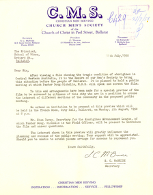 Federation University Historical Collection
Letter - Correspondence, S.C. McBride, Letter concerning the work of Pastor Doug Nicholls and the Aborigines Advancement League, 1958, 11/07/1958
The Church Men's Society was a part of the Church of Christ in Peel Street, Ballarat. In 1958 the President was C. Thomas, and S.C. McBride was Secretary. The Aborigines Advancement League (also known as the Aboriginal Advancement League) claims to be the oldest Aboriginal organisation in Australia. It is primarily concerned with Aboriginal welfare issues and the preservation of Aboriginal culture and heritage, and is based in Melbourne. The League was established in 1957 as a response to an enquiry by retired magistrate, Charles McLean, into the circumstances of Aboriginal Victorians. McLean was critical of conditions in the Lake Tyers and Framlingham Aboriginal Reserves. McLean recommended that persons of mixed Aboriginal and European descent be removed from the reserves. The people of Lake Tyers objected to this, and the League was formed out of their campaign. The new League drew from two already existing organisations, the Australian Aborigines League, established 1934 and the Save the Aborigines Committee, which had been established in 1955 as a response to the Warburton Ranges crisis. Founding President of the League was Gordon Bryant, with Doris Blackburn as Deputy President, Stan Davey as Secretary and Douglas Nicholls as Field Officer. Early activities included lobbying for a referendum to change the Australian constitution to allow the Federal government to legislate on Aboriginal affairs, and an establishing a legal defence fund for Albert Namatjira, after he was charged with supplying liquor to an Aboriginal ward.[1] By 1967 it had moved to being fully controlled by Aboriginal people with Bill Onus as the first Aboriginal President.Typed letter on Church Men's Society (C.M.S.) letterhead. The letter concerns a film 'showing the tragic condition of aborigines in Central Western Australia ...' The C.M.S. (Ballarat) planned to hold a public meeting in Ballarat at which Pastor Doug Nicholls, M.B.E. will speak and screen the film. doug nicholls, c. thomas, aborigines, ballarat town hall, stan davey, s.c. mcbride, letterhead -
 Ballarat Heritage Services
Photograph - Colour, Earth Banks, Old Sarum, England, 2016, 01 November 2016
William the Conqueror inherited Old Sarum from the last Saxon king of England. It was an ideal site for a royal castle. It was here in 1070 that William paid off his army after a long and bitter campaign in northern England. It was here in 1086 that he called together all the major landholders in England so they could swear allegiance to him. It was a crucial moment. The Domesday Book was being written, a threatened Viking invasion had only just been averted and William's eldest son was in armed rebellion. Old Sarum was an important place where this Norman king of England held power. In 1794 the Ordnance Survey set out to check the accuracy of the first mapping of Southern England, which had begun ten years earlier. From a point just below Old Sarum Lieutenant William Mudge laid out a base-line 36,574 feet (11,253 metres) long. From each end of the line the positions of distant places were plotted using a huge theodolite made in 1791 by Jesse Ramsden. The accuracy of the process, which was repeated all over England, depended on Jesse Ramsden's craftsmanship and on William Mudge's surveying skill in setting out this first base-line from Old Sarum. The nearer end of Mudge's line is marked by an inscribed stone beside the modern A345 at Old Sarum. ordnance survey, william mudge, jesse ramsden, william the conqueror, old sarum, saxon, 1086, england -
 Ballarat Heritage Services
Photograph - Colour, Earth Banks, Old Sarum, England, 01 November 2016
William the Conqueror inherited Old Sarum from the last Saxon king of England. It was an ideal site for a royal castle. It was here in 1070 that William paid off his army after a long and bitter campaign in northern England. It was here in 1086 that he called together all the major landholders in England so they could swear allegiance to him. It was a crucial moment. The Domesday Book was being written, a threatened Viking invasion had only just been averted and William's eldest son was in armed rebellion. Old Sarum was an important place where this Norman king of England held power. In 1794 the Ordnance Survey set out to check the accuracy of the first mapping of Southern England, which had begun ten years earlier. From a point just below Old Sarum Lieutenant William Mudge laid out a base-line 36,574 feet (11,253 metres) long. From each end of the line the positions of distant places were plotted using a huge theodolite made in 1791 by Jesse Ramsden. The accuracy of the process, which was repeated all over England, depended on Jesse Ramsden's craftsmanship and on William Mudge's surveying skill in setting out this first base-line from Old Sarum. The nearer end of Mudge's line is marked by an inscribed stone beside the modern A345 at Old Sarum. ordnance survey, william mudge, jesse ramsden, william the conqueror, old sarum, saxon, 1086, england -
 Ballarat Heritage Services
Photograph - Colour, Stonework, Old Sarum, England, English Heritage Site, 01 November 2016
William the Conqueror inherited Old Sarum from the last Saxon king of England. It was an ideal site for a royal castle. It was here in 1070 that William paid off his army after a long and bitter campaign in northern England. It was here in 1086 that he called together all the major landholders in England so they could swear allegiance to him. It was a crucial moment. The Domesday Book was being written, a threatened Viking invasion had only just been averted and William's eldest son was in armed rebellion. Old Sarum was an important place where this Norman king of England held power. In 1794 the Ordnance Survey set out to check the accuracy of the first mapping of Southern England, which had begun ten years earlier. From a point just below Old Sarum Lieutenant William Mudge laid out a base-line 36,574 feet (11,253 metres) long. From each end of the line the positions of distant places were plotted using a huge theodolite made in 1791 by Jesse Ramsden. The accuracy of the process, which was repeated all over England, depended on Jesse Ramsden's craftsmanship and on William Mudge's surveying skill in setting out this first base-line from Old Sarum. The nearer end of Mudge's line is marked by an inscribed stone beside the modern A345 at Old Sarum. ordnance survey, william mudge, jesse ramsden, william the conqueror, old sarum, saxon, 1086, england -
 Ballarat Heritage Services
Photograph - Colour, Stonework, Old Sarum, England, English Heritage Site, 2016, 01 November 2016
William the Conqueror inherited Old Sarum from the last Saxon king of England. It was an ideal site for a royal castle. It was here in 1070 that William paid off his army after a long and bitter campaign in northern England. It was here in 1086 that he called together all the major landholders in England so they could swear allegiance to him. It was a crucial moment. The Domesday Book was being written, a threatened Viking invasion had only just been averted and William's eldest son was in armed rebellion. Old Sarum was an important place where this Norman king of England held power. In 1794 the Ordnance Survey set out to check the accuracy of the first mapping of Southern England, which had begun ten years earlier. From a point just below Old Sarum Lieutenant William Mudge laid out a base-line 36,574 feet (11,253 metres) long. From each end of the line the positions of distant places were plotted using a huge theodolite made in 1791 by Jesse Ramsden. The accuracy of the process, which was repeated all over England, depended on Jesse Ramsden's craftsmanship and on William Mudge's surveying skill in setting out this first base-line from Old Sarum. The nearer end of Mudge's line is marked by an inscribed stone beside the modern A345 at Old Sarum. ordnance survey, william mudge, jesse ramsden, william the conqueror, old sarum, saxon, 1086, england -
 Ballarat Heritage Services
Photograph - Colour, Stonework and well, Old Sarum, England, English Heritage Site, 2016, 01 November 2016
William the Conqueror inherited Old Sarum from the last Saxon king of England. It was an ideal site for a royal castle. It was here in 1070 that William paid off his army after a long and bitter campaign in northern England. It was here in 1086 that he called together all the major landholders in England so they could swear allegiance to him. It was a crucial moment. The Domesday Book was being written, a threatened Viking invasion had only just been averted and William's eldest son was in armed rebellion. Old Sarum was an important place where this Norman king of England held power. In 1794 the Ordnance Survey set out to check the accuracy of the first mapping of Southern England, which had begun ten years earlier. From a point just below Old Sarum Lieutenant William Mudge laid out a base-line 36,574 feet (11,253 metres) long. From each end of the line the positions of distant places were plotted using a huge theodolite made in 1791 by Jesse Ramsden. The accuracy of the process, which was repeated all over England, depended on Jesse Ramsden's craftsmanship and on William Mudge's surveying skill in setting out this first base-line from Old Sarum. The nearer end of Mudge's line is marked by an inscribed stone beside the modern A345 at Old Sarum. ordnance survey, william mudge, jesse ramsden, william the conqueror, old sarum, saxon, 1086, england -
 Ballarat Heritage Services
Photograph - Colour, Stonework, Old Sarum, England, English Heritage Site, 01 November 2016
William the Conqueror inherited Old Sarum from the last Saxon king of England. It was an ideal site for a royal castle. It was here in 1070 that William paid off his army after a long and bitter campaign in northern England. It was here in 1086 that he called together all the major landholders in England so they could swear allegiance to him. It was a crucial moment. The Domesday Book was being written, a threatened Viking invasion had only just been averted and William's eldest son was in armed rebellion. Old Sarum was an important place where this Norman king of England held power. In 1794 the Ordnance Survey set out to check the accuracy of the first mapping of Southern England, which had begun ten years earlier. From a point just below Old Sarum Lieutenant William Mudge laid out a base-line 36,574 feet (11,253 metres) long. From each end of the line the positions of distant places were plotted using a huge theodolite made in 1791 by Jesse Ramsden. The accuracy of the process, which was repeated all over England, depended on Jesse Ramsden's craftsmanship and on William Mudge's surveying skill in setting out this first base-line from Old Sarum. The nearer end of Mudge's line is marked by an inscribed stone beside the modern A345 at Old Sarum. ordnance survey, william mudge, jesse ramsden, william the conqueror, old sarum, saxon, 1086, england -
 Ballarat Heritage Services
Photograph - Colour, Sign Explaining toilets, Old Sarum, England, English Heritage Site, 01/11/2016
William the Conqueror inherited Old Sarum from the last Saxon king of England. It was an ideal site for a royal castle. It was here in 1070 that William paid off his army after a long and bitter campaign in northern England. It was here in 1086 that he called together all the major landholders in England so they could swear allegiance to him. It was a crucial moment. The Domesday Book was being written, a threatened Viking invasion had only just been averted and William's eldest son was in armed rebellion. Old Sarum was an important place where this Norman king of England held power. In 1794 the Ordnance Survey set out to check the accuracy of the first mapping of Southern England, which had begun ten years earlier. From a point just below Old Sarum Lieutenant William Mudge laid out a base-line 36,574 feet (11,253 metres) long. From each end of the line the positions of distant places were plotted using a huge theodolite made in 1791 by Jesse Ramsden. The accuracy of the process, which was repeated all over England, depended on Jesse Ramsden's craftsmanship and on William Mudge's surveying skill in setting out this first base-line from Old Sarum. The nearer end of Mudge's line is marked by an inscribed stone beside the modern A345 at Old Sarum. Colour photograph of a sign explaining toilets at Old Sarum, English Heritage Siteordnance survey, william mudge, jesse ramsden, william the conqueror, old sarum, saxon, 1086,, england -
 Ballarat Heritage Services
Photograph - Colour, Old Sarum, England, 2017, 01 November 2016
William the Conqueror inherited Old Sarum from the last Saxon king of England. It was an ideal site for a royal castle. It was here in 1070 that William paid off his army after a long and bitter campaign in northern England. It was here in 1086 that he called together all the major landholders in England so they could swear allegiance to him. It was a crucial moment. The Domesday Book was being written, a threatened Viking invasion had only just been averted and William's eldest son was in armed rebellion. Old Sarum was an important place where this Norman king of England held power. In 1794 the Ordnance Survey set out to check the accuracy of the first mapping of Southern England, which had begun ten years earlier. From a point just below Old Sarum Lieutenant William Mudge laid out a base-line 36,574 feet (11,253 metres) long. From each end of the line the positions of distant places were plotted using a huge theodolite made in 1791 by Jesse Ramsden. The accuracy of the process, which was repeated all over England, depended on Jesse Ramsden's craftsmanship and on William Mudge's surveying skill in setting out this first base-line from Old Sarum. The nearer end of Mudge's line is marked by an inscribed stone beside the modern A345 at Old Sarum. ordnance survey, william mudge, jesse ramsden, william the conqueror, old sarum, saxon, 1086, england