Showing 3443 items matching "distance"
-
 Mont De Lancey
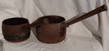
Domestic object - Saucepans, C.Clark & Co, 1900's
This large deep pan (with a long handle) was used by pioneer families, mainly rural folk, that needed a pan which could cope with an open fire heat source, in or mainly outside the homestead. This pan was used in the early to late 1900's for the stews and other meals required by hard working stockmen and farmers that had irregular lunch and dinner or tea breaks under sometimes hard and gruelling conditions. Hot plates were normally not in use.Two vintage black sooted heavy cast iron cooking pots or saucepans with rounded sides and long straight fluted handles angled at approximately sixty degrees upwards. This angle ensured that both distance from flame intensity and least bending of knees when lifting is at a minimum. It was used on the open fire or on a wood fired stove, possible on the fire direct.'6 pints' has indecipherable inscription. On the back of the '4' pints one - 'C. Clark & Co. R 455279 - Best Quality'cooking equipment, cooking pots, cooking, saucepans, pots, kitchen equipment -
 Darebin Parklands Association
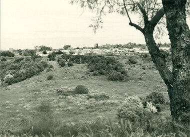
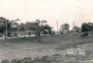
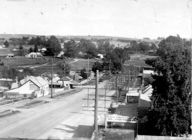
Mulberry Spur with views, 1974, 1974
The widespread artichoke weed and other environmental weeds had to be cleared before planting could commence.B&W photograph. Land proposed as Parklands. View of houses in Bennett Street, Alphington and Northcote Hill in the distance. The artichoke weed can be seen across the foreground. This item and all other Darebin Parklands Association archival material is now held by State Library Victoria (Accession No: YMS 13746). Please contact State Library Victoria if access is required. -
 Bendigo Historical Society Inc.
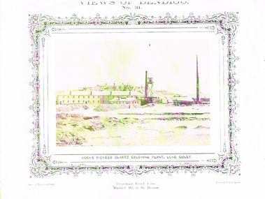
Photograph - LONG GULLY HISTORY GROUP COLLECTION: KOCK'S PIONEER QUARTZ CRUSHING PLANT LONG GULLY
BHS CollectionYellow tone photo of Kock's Pioneer Quartz Crushing Plant, Long Gully. Views of Bendigo No 31. Decorative border around the photo. Name printed under the photo. N J Caire Photo, Sandhurst. Casey & Wenburn's Print. Fu?? & Holmes?, Agents. Printed under the photo is - Perseverance United Claim. Wind-mill Hill in the Distance.bendigo, history, long gully history group, the long gully history group - kock's pioneer quartz crushing plant, long gully, n j caire, casey & wenburn's print, fu?? & holmes? agents -
 Melbourne Tram Museum
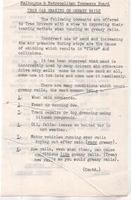
Document - Instruction, Melbourne & Metropolitan Tramways Board (MMTB), "MMTB Tram Car Braking on Greasy Rails", 1/05/1975 12:00:00 AM
Instruction - printed on both sides of a sheet cut to fit into Rule Books, titled "MMTB Tram Car Braking on Greasy Rails", signed by R. C. Drummond Traffic Manager 1/5/1975. Gives instructions about braking, use of sand, conditions, skidding, wheel flats and braking distances. See also 3652.1 for another copy.trams, tramways, drivers, braking, instructions, tramcars, training -
 Melbourne Tram Museum
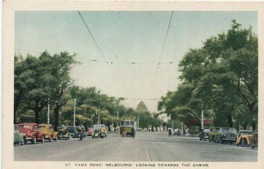
Postcard, Nu-color-Vue, "St Kilda Road, Melbourne looking towards the shrine", c mid 1950s
Postcard - colour titled "St Kilda Road, Melbourne looking towards the shrine". Has wide bodied tram in the distance and a number of vehicles, mostly parked, pedestrians and a shelter. On the rear - has a divided back, with details noting that the road has the capacity of 10 car lanes and twin tram lines. Produced by Nucolorview, using a genuine Kodachrome photographOn the rear has the stamp of Graeme S Breydon - see image i2.trams, tramways, melbourne, st kilda rd, shrine of remembrance, shelters -
 Lakes Entrance Historical Society
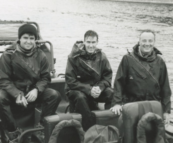
Photograph, Lakes Post Newspaper, Australian Army at Lakes Entrance Victoria, 1/03/1996 12:00:00 AM
Black and white photograph of Cpl Amir Tito Mick Allen and Giz McKechnie of Australian Army training in a Rigid Inflatable boat on Cunninghame Arm Lakes Entrance Victoria. Also a black and white photograph taken at the same time at New Works Jetty another R I B shown in distance Nine members were involved in training military history, people, r a a f, world war 1939 - 1945 -
 Orbost & District Historical Society
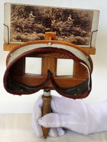
stereoscope, April 1920
This is a wood stereoviewer with folding handle The viewer has two lenses at a set distance in the wooden hood which is lined in green velvet. The pictures can be moved vertically on the slide holder in order to focus them. These devices became popular in the middle of the 19th century. This is probably a Holmes type stereoscope, named after its inventor, Oliver Wendell Holmes (1860). Velvet lined view mask with engravwed patterns. Frame is silky oak wood with a handle underneath.stereoscope audio-visual appliances -
 Eltham District Historical Society Inc
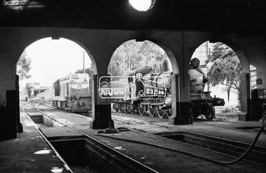
Photograph, Steam locomotive D3-677 and Diesel locomotive T-328 outside the locomotive shed, Echuca Railway Station, October 1962, 1962
The coal loader is visible in the distance. Image dated as October 1962 based on same image in Port of Echuca collection (print 17.5 x 24.5cm) On the reverse of photo:" Photo by: George L. Coop Oct 1962". Crossed out, in black pen: "565". In pencil:" D3... T Class diesel 1954 Intro" https://victoriancollections.net.au/items/59e7e43321ea6a13c065088bDigital TIFF file Scan of 35mm Ilford FP3 black and white negative transparencyd3-677, d3-class steam locomotive, echuca railway station, george coop collection, railway workshop, t-328, t-class diesel electric locomotive -
 Eltham District Historical Society Inc
Photograph, A walk through the cemetery at Kangaroo Ground, Diana Bassett-Smith, 1 October 2001, 2001
A huge warrior of a gum tree still stands sentinel at the wrought iron gates. In the distance some pencil pines. Survivors too of the disastrous bushfires which in the past have swept the district. A brief collection of reminiscences by Diana Bassett-Smith of locals who are buried at Kangaroo Ground Cemetery along with 17 photographs following a visit on 1 October 2001.Colour photograph print1983 bushfire, air vice marshall wackett, ambrose erswell, barry roach-pierson, bill pelling, billy roach-pierson, birrarung, bourchiers road, ca 13, crichton, david grant, diamond street, diana bassett-smith, donald grant, donaldson road, dorrie bourchier, duff, early settlers, elizabeth cottee, ewan cameron mp, grey house, helen kohn, isabella grant (nee stevenson), jack bourchier, james balfour, james wilson, jean stewart, jessie bull (nee haughton), jimmy cook, jocelyn, joseph stevenson, judge book village, judith furphy, kangaroo ground cemetery, kay roach-pierson, keith jocelyn, kraft foods, lacey, lloyd stuart, louise grant (nee gordon), mardi crocker, marion erswell, ned haughton, nursery, pam chevallier, passiona, peter bassett-smith, pigeon bank, rath, ricketson, robinson, ruth boyd, steven crawford baes, tintagell, tosch, vera jackson, wackett trainer, watershed jackson, willandra poultry farm, zac crocker -
 Eltham District Historical Society Inc
Photograph, Alistair Knox Park, Eltham, c.1970, 1970c
View from northwest corner showing survey pegs for trees and two ponds. Main Road has been duplicated. Bridge Street intersection showing the rock wall on the east side of the original Main Road (Maria Street). Burgoyne's Store and Eltham Uniting Church in distance at centre right and Our Lady Help of Christians at centre left.In February 1968 an unknown person took a series of photos from the Eltham Hotel at Pitt Street heading north along Main Road through the shopping centre to just north of Elsa Court covering the length of the section of Main Road which was duplicated shortly thereafter. Shows the condition and environment of the streesscape of Main Road, Eltham immediately prior to the duplication between Pitt Street and Elsa Court through the shopping centre. Also shows a number of shops and businesses that operated at that time.Black and white photographduplication, eltham, main road, bridge street, burgoyne's shop, eltham uniting church, our ladys church, maria street -
 Kiewa Valley Historical Society
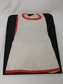
Apron - Child's
Due to relative long distance to haberdashery stores majority of children's garments were hand made by a local talented seamstress or mother/relative. This apron is very similar in style to the other children's clothing which indicates it could have been made in the early - mid 1900's. It is preventative of aprons which little girls wore over their dresses at the time. This items has good historical significance because it shows the style of aprons which little girls wore over their dresses in the Kiewa Valley during the early to mid 1900's. This is part of the children's clothes in the KVHS collections which gives this item more interpretive capacity. Natural coloured linen with red binding around the edges. 2 white buttons. Would fit a small child.clothing. children. apron. -
 Kiewa Valley Historical Society
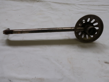
Candle Holder - Wall Bracket
This sconce - wall mounted candle holder or light fixture is simple / basic without any decoration. It was able to swivel. It may have been used on either the interior o exterior walls of buildings. The light is usually, but not always, directed upwards and outwards, rather than down. The long bracket kept the candle a safe distance from the wall and ceiling.This sconce was used by a resident of the Kiewa Valley.Shiny metal rod with candle holder at one end and a small thin rod at the other for attaching to a device on a wall. The candle holder is surrounded by a metal shallow 'cup' with 11 oval holes enabling the wax to fall to the centre where there is a hollow globe and allowing the light to shine upwards.sconce, candle holder, wall mounted candle holder -
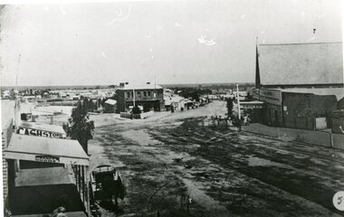 Stawell Historical Society Inc
Photograph, Lower Main Street Stawell looking West towards the Unicorn Hotel later Coffee Palace
Lower Main Street looking West towards the Unicorn Hotel later the Coffee Palace. c1882 formerly the Castlemaine Hotel and before then the Royal Hotel. Bullock wagons and horse drawn buggies in street. Railway Goods Shed and Railway Station and Church of Christ visible in distance. Anglican Church roof on right, J & A Price Grocer and Spirit Merchants.B/W. Main Street opposite where the Town Hall is now. Stawell Coffee Palace is in the centre and the Anglican Church on the right. The date is about 1880.?stawell business streetscape -
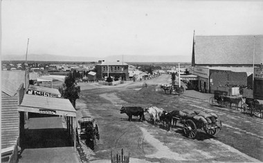 Stawell Historical Society Inc
Photograph, Lower Main Street Stawell looking West towards the Unicorn Hotel later Coffee Palace c1885
Lower Main Street looking West towards the Unicorn Hotel later the Coffee Palace. c1882 formerly the Castlemaine Hotel and before then the Royal Hotel. Bullock wagons and horse drawn buggies in street. Railway Goods Shed and Railway Station and Church of Christ visible in distance. Anglican Church roof on right, J & A Price Grocer and Spirit Merchants.Victorian Views. C. Herbert, Photo. Stawell 1878stawell business streetscape -
 Melbourne Tram Museum
Photograph, Cable tram 41 Bridge Road Richmond, c1900
The photograph shows cable, trailer 41 climbing the Bridge Road hill just west of Waltham Steet bound for the city. A second cable set can be seen in the distance, bound for Hawthorn Bridge. Nearly all of the buildings on this south side of Bridge Road remain today including the former Forbes and Sons building. Photo possibly dated c1900.Yields information about cable trams in Bridge Road Richmond and associated buildings.Photograph, black and white, plain papertrams, tramways, cable tram, bridge road, tram 41, richmond -
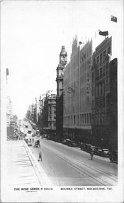 Melbourne Tram Museum
Postcard, Rose Stereograph Co, "Bourke Street Melbourne", c1935
Rose Series postcard No. P 10532 titled "Bourke Street Melbourne", looking west from near Swanston Street. Has two cable trams in the far distance. The Myer Emporium building is shown along with the GPO. A building crane can be seen on the left side of the photograph where Diamond House is under construction for Dunklings which was completed in 1936.Yields information about Bourke Street c1935Postcard - printed real photograph with Rose Stereograph Co. name on the rear.trams, tramways, cable trams, bourke st -
 Melbourne Tram Museum
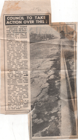
Newspaper - "Council to take action over this", Herald Sun, 1955
The article and photo reports on the poor condition of the Victorian Railways operated St Kilda to Brighton tram line in St Kilda St, Brighton. This section of line closed during 1957. The Council reported that it had briefed a QC about the matter. The Railways were responsible for road maintenance and track maintenance. The donor, noted that it is tram 32 in the far distance.Yields information about the condition of the St Kilda St Brighton prior to the tramway closure.Newspaper clipping titled - "Council to take action over this" - Melbourne Sun 21/7/1955"Melb "Sun" Thurs 21 July 1955 inside page 9"trams, tramways, vr trams, st kilda st, brighton, track maintenance, tram tracks -
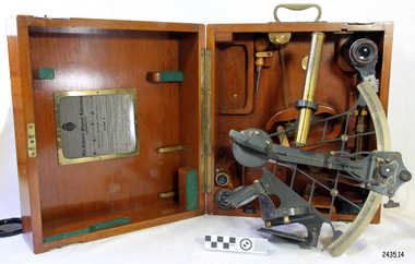 Flagstaff Hill Maritime Museum and Village
Instrument - Navigational Sextant, 1882-1890
A sextant is an astronomical instrument used to determine latitude and longitude at sea by measuring angular distances, especially the altitudes of the sun, moon, and stars. It is a doubly reflecting navigation instrument and used mainly by sailors to measure the angular distance between two visible objects. The name comes from the Latin sextans, or “sixth part of a unit,” because the sextant’s arc can be 60° or 120° of a circle depending on the model used. The primary use was to measure the angle between an astronomical object and the horizon for the purposes of celestial navigation. The estimation of this angle is known as sighting or shooting the object, or taking a sight. This angle and the time when it was measured is used in order to determine Greenwich Mean Time and hence longitude. Sighting the height of a landmark on land can also give a measure of distance from that object. History: The development of the sextant was as an improvement over the octant, an instrument designed to measure one's latitude. The octant was first implemented around 1731-present but can only measure angles up to 45°. As larger angles were needed to allow the measurement of lunar objects - moon, stars and the sun - at higher angles, the octant was superseded by the sextant. The sextant is a similar instrument but better made and allows larger angles from 60° to 120°. This improvement allows distances to be accurately calculated thereby giving longitude when used with a chronometer. The sextant was derived from the octant in 1757, eventually making all previous instruments used for navigational positioning obsolete. The sextant had been attributed to by John Hadley (1682–1744) and Thomas Godfrey (1704–1749), but reference to the sextant was also found later in the unpublished writings of Isaac Newton (1643–1727). Earlier links can be found to Bartholomew Gosnold (1571–1607) indicating that the use of a sextant for nautical navigation predates Hadley's implementation. In 1922, the sextant was modified for aeronautical navigation by Portuguese navigator and naval officer Gago Coutinho. It should be noted that the octant and quadrant are in the same family as they were, and all are, regarded as sextants. The sextant is representative of it's type and although not fully complete it demonstrates how 18th,19th and 20th century mariners determined their latitude and longitudinal to determine their position on a chart, allowing them to navigate there way across the world's oceans. It also demonstrates the skill and workmanship of the early instrument makers that operated scientific instrument businesses from London and other areas of England to provide most of the navigational instrumentation used by commercial and military navies of the time.Sextant with square, fitted box of polished wood, "Hezzanith" brand. Box contains many parts for the sextants use. On certificate "Heath & Co, London. Sextant Number Y 822". Catch on lid "DEFIANT LEVER" and "PATENT NUMBER 187.10". Maker's certificate is attached to the inside of the box.flagstaff hill, warrnambool, shipwrecked-coast, flagstaff-hill, flagstaff-hill-maritime-museum, maritime-museum, shipwreck-coast, flagstaff-hill-maritime-village, sextant box, sextant, hezzanith, heath & co, navigational instrument, george wilson heath, astronomical instrument, instrument manufacturers, scientific instrument, navigation, celestial navigation, octant, quadrant, lunar navigation -
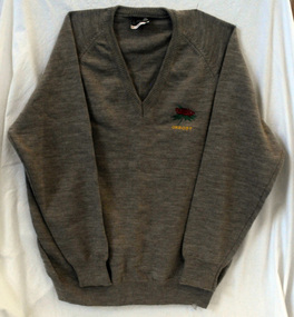 Orbost & District Historical Society
jumper, 1970's -1980's
This jumper was worn by John Court as an employee of Orbost Shire Council. Orbost was at first included in the Bairnsdale Shire from 1882 and was later part of the Tambo Shire. Because of travelling distances the Croajingalong Shire was created in 1892 (name changed to Orbost Shire 17.2.1893 with James Cameron as the first Shire President. In 1994 it amalgamated to become part of East Gippsland Shire Council.Local governments play an important role in the lives of citizens in Australia. Local government authorities exist to provide services and amenities to local communities, and are also responsible for regulating and providing services for land and property in their district. This item is representative of a time when Orbost had its own Shire Council.A fawn coloured V - necked long-sleeved woollen jumper. It has a waratah emblem embroidered in red with green leaves. Below this is embroidered the word ORBOST in gold.uniform jumper orbost-shire-council court-john -
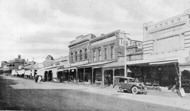 Stawell Historical Society Inc
Postcard, Front Cover, Upper Main Street Stawell looking East & & looking West -- 3 Photos -- Postcards 1920's
Views of Stawell. INCLUDES view of Main Street looking East showing from right Strangio & Pizione fruit shop. Sun Printing Works. Tea Rooms. King. Carters Boot Shop. Taylor. Bull and Mouth in distance. Car visible. ALSO Main Street Looking West showing from right Norman A Harding Taylor and Outfitter. Geo Mitchell & Sons stawell businesses streetscape -
 Linton and District Historical Society Inc
Photograph, Taylors Super Snaps Ballarat, Sussex Street, Linton
Photograph taken from high vantage point further along Sussex Street. Visible east side: Edinburgh Bakery, Preston's shop, Wishart's blacksmiths. Church of England vicarage in the distance. Visible west side: roofs of Morgan's and Sandow's stores. The photograph is undated but thought to have been taken in the 1940s, as there are electricity poles in the street. (Electricity came to Linton in 1939).Very small photograph of Sussex Stret, Linton, view to south-east.sussex street linton -
 Federation University Historical Collection
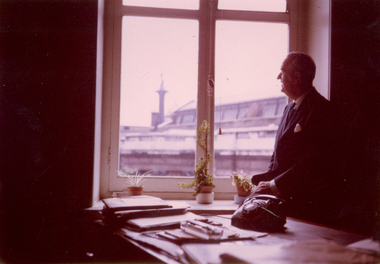
Photograph - Photograph, Colour, Frank Wright
Frank Wright was a renown resident of Smeaton, where he was born. He lived at Laura Villa, and attended Smeaton State School. His father William was a gold miner and his mother's name was Sarah. Their family won many singing and instrumental awards. Frank was tutored by Percy Code and was awarded a gold medal for the highest marks in the ALCM examinations in the British Colonies at the age of seventeen years. He became the Australian Open Cornet Champion by the age of eighteen. A year later, Frank conducted the City of Ballarat Band, and later the Ballarat Soldiers’ Memorial Band. He formed the Frank Wright Frisco Band and Frank Wright and his Coliseum Orchestra. These bands won many South Street awards, and Frank as conductor won many awards in the Australian Band Championship contest. In 1933 Frank Wright sailed to England to conduct the famous St Hilda’s Band and was later appointed Musical Director of the London County Council, where he organized many amazing concerts in parks, in and around the London district. He was made Professor of Brass and Military Band Scoring and conducted at the Guildhall of Music and Drama. Frank was often invited to adjudicate Brass Band Championships around Europe, in Australia, including South Street and in New Zealand. The Frank Wright Medal at the Royal South Street competition is awarded to an individual recognized as making an outstanding contribution to brass music in Australia.Frank Wright .1) & .2) Two coloured photographs of a man dressed in suit and tie with a pocket handkerchief, leaning against a mantel piece, above which is a photograph of a crowd of people watching a performance at a park with a sound shell in the distance. The man is frank Wright. .3) A coloured photograph of a man dressed in a suit looking out an office window. The man is Frank Wright.frank wright, portrait -
 Federation University Historical Collection
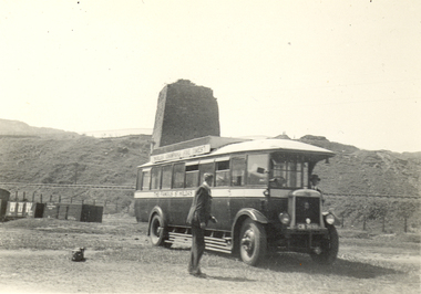
Photograph - Black and White, Frank Wright, St Hilda's Band bus at Llanelly, Wales, 29/5/1934
Frank Wright was a renown resident of Smeaton, where he was born on 2 August 1901. He lived at Laura Villa, and attended Smeaton State School. His father William was a gold miner and his mother's name was Sarah. Their family won many singing and instrumental awards. Frank was tutored by Percy Code and was awarded a gold medal for the highest marks in the ALCM examinations in the British Colonies at the age of seventeen years. He became the Australian Open Cornet Champion by the age of eighteen. A year later, Frank conducted the City of Ballarat Band, and later the Ballarat Soldiers’ Memorial Band. He formed the Frank Wright Frisco Band and Frank Wright and his Coliseum Orchestra. These bands won many South Street awards, and Frank as conductor won many awards in the Australian Band Championship contest. In 1933 Frank Wright sailed to England to conduct the famous St Hilda’s Band and was later appointed Musical Director of the London County Council, where he organized many amazing concerts in parks, in and around the London district. He was made Professor of Brass and Military Band Scoring and conducted at the Guildhall of Music and Drama. Frank was often invited to adjudicate Brass Band Championships around Europe, in Australia, including South Street and in New Zealand. The Frank Wright Medal at the Royal South Street competition is awarded to an individual recognized as making an outstanding contribution to brass music in Australia.Black and white photograph of an early 1930's bus parked on the grass in the foreground, with a man standing on the hidden steps of the bus and another man walking in front. In the middle distance rail lines can be seen on an embankment rising behind a post and wire fence and in the background a tower rises on the closest hill. The bus is the St Hilda's Band bus and the place is Llanelly in Wales.Written in pencil on back - Llanelly, Wales, 29/5/34frank wright, 1930's bus, welsh tower, st hilda's band, sthilda's band bus -
 Bendigo Historical Society Inc.
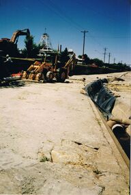
Photograph - CASTLEMAINE GAS COMPANY COLLECTION: PHOTO WATER CHANNEL
Water channel, 2 excavators, worker climbing ladder. Poppet head of a mine in background, Rubber tyred tractor with blade and trencher fitted in creek bed, larger excavator is adjacent to the tractor on the left bank, light posts and wire along the left bank, central gutter has plastic laid for a short distance, Pipe held down with sandbags in centre gutter.Kodakorganisation, industry, gas and fuel -
 Port Melbourne Historical & Preservation Society
Photograph - Beacon Cove, 2006
Photographic images of properties in Port Melbourne. Image may have been taken by a PMHPS member or scanned from a past resident or taken for real estate sale purposes. Beacon Cove; two images looking West towards the Bay showing the light rail line, bike path and waterfront developments in distance. One image includes tram. (January 2006)built environment - domestic, transport - tramways, beacon cove, light rail, tram -
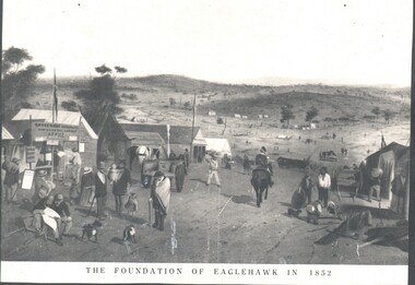 Bendigo Historical Society Inc.
Photograph - WES HARRY COLLECTION: FOUNDATION OF EAGLEHAWK IN 1852, 1852
Photograph of an artwork depicting and early mining camp. In the foreground there is a settlement consisting of tents and some wooden buildings, There are numerous people of all ages on the street and a trooper on horseback. The road through the settlement is running down to a broad valley with some low hills in the distance. There are several tents and rough dwellings at the base of these hills. Along the bottom of the picture is written The foundation of Eaglehawk in 1852.topic, mining, eaglehawk, mining settlement, eaglehawk, diggers, early bendigo -
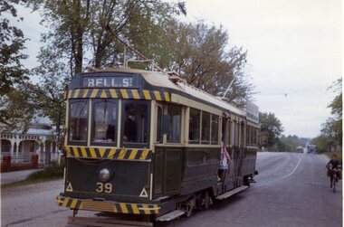 Ballarat Tramway Museum
Photograph - Colour Photograph/s, Travis Jeffrey, 6/11/1962 12:00:00 AM
Colour photograph of Ballarat No. 39 leaving Gregory St. loop in Lydiard St. Nth. (House to the left of the photo is No. 803). Tram has the destination of Bell St and a SEC Electric Cooking roof advertisement. Photo dated 6/11/1962. Note outbound tram in distance, and paper or delivery boy on bike on right hand side of the photograph. On Kodacolor paper."76Ed" in blue ink, date stamp 6 Nov 1962" in red ink.gregory st., lydiard st., tram 39 -
 Ballarat Tramway Museum
Photograph - Colour Print/s - set of 4, Dave O'Neill?, late 1980s
Yields information through a photograph of a former Ballarat tram (No. 43) who was returned to Geelong and displayed at Queens Park as Geelong 40. Shows the location the tram was stored in and why it deteriorated by the mid 1980's.Set of four colour photographs of Geelong No. 40, Ballarat No. 43, Queens Park Geelong. .1 - shows tram in the enclosure. .2 - close up of one end - showing its Geelong number. .3 - the other end - showing its Ballarat number. .4 - Side view with white combi van in the distance - Dave O'Neil's? Taken late 1980's?geelong, queens park, newtown, tram 40 -
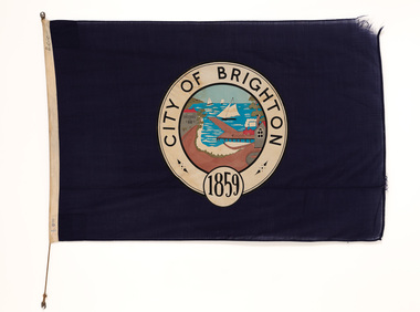 Bayside Gallery - Bayside City Council Art & Heritage Collection
Flag, Evan Evans, City of Brighton flag
This flag features the City of Brighton crest which was used by the City of Brighton until 1970, when an official Coat of Arms was issued by the British College of Heraldry. Brighton was first incorporated as a borough on 18 January 1859, it became a town on 18 March 1887 and was proclaimed a city on 12 March 1919.Navy blue flag with circular crest in the centre with the words CITY OF BRIGHTON 1859 in black ink in a white border around the outside. A polychrome scene of the Brighton crest is in the centre showing the coastline with a pier extending to the water, sail boats in the distance, a train on the right of the pier, buildings on the left and the sandy beach at the base. The flag has rope woven through left side.flag, brighton, city of brighton, crest, bayside -
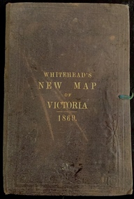 Kew Historical Society Inc
Map, Whitehead's Map of Victoria, With Alphabetical Key, 1869, 1869
When E. Whitehead's New Map of Victoria was released in 1869, an advertisement in the Bendigo Advertiser (16 July 1869) noted that: "This beautifully engraved Map has been revised and brought down to the present time; and, with the Alphabetical Key, is the most complete and the cheapest Map ever published; Price, 6d plain; 1s colored; 2s 6d in case; on linen, post free, 2d extra. E.. WHITEHEAD and CO, Publishers, 67 Collins-street east." The following year, 1870, Whitehead's promoted the edition in the Portland Guardian and Normanby General Advertiser (3 January 1870), advising that: "WHITEHEAD'S NEW MAP OF VICTORIA, 1869 ... is corrected to the latest date, and around is arranged an Alphabetical Key, with Post Towns and Money Order Olffices marked. The Map being divided into squares and numbered, by reference to the Key any place can be found immediately. Price Is beautifully colored, or mounted on linen in case, 2s 6d. Post free, 2d extra, in Victoria. B. Whitehead and C0., Puolishers, 67 Collins-street East, Melbourne". In the same edition of the Portland Advertiser, they also promoted their business generally, saying: "E WHITEHEAD and Co., Stationers, Engravers, Lithographers, 67 Collins street East, execute every description of Lithographic PRINTING, BILL-HEADS. NOTE Headings. Business Dies Engraved and Embossed on Envelopes &c. ARMS, MONOGRAMS, AND CRESTS Engraved and Embossed in Colour, superior to any other house in the Colony. Specimens, post free, 2d. Lithographers, &c, to H.R.H. the Duke of Edinburgh, and Die-inkers and Embossers to His Excellency Sir J. H. T. Manners-Sutton, K C.B. Orders executed for the Trade". Whitehead’s New Map of Victoria 1869 is is an important record of region created towards the end of the Victorian Gold Rush (1851-1869). In addition to its historical significance, this is a rare map, of which the only known copies in Australian public collections are those held at the National Library of Australia, the State Library of Victoria, State Library of New South Wales and the University of Queensland Library.Map of Victoria with gold mining areas, notes on topography, transport routes. Relief shown by hachures. List of towns with distance from Melbourne in map margin. [Melbourne] : Printed & Published by ... E Whitehead & Co ... 67 Collins Street East, 1869 1 map : col., mounted on linen ; 38.4 x 55.4 cm, folded to 18 x 12 cm.Cover "WHITEHEAD'S NEW MAP OF VICTORIA 1869"maps - victoria - 1860s, e whitehead's new map of victoria 1869, whitehead's map of victoria with alphabetical key 1869, cartography, gold rush