Showing 1936 items
matching eltham park
-
 Eltham District Historical Society Inc
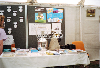
Negative - Photograph, Eltham Shire Council display, 1987 Eltham Community Festival, Alistair Knox Park, 7 Nov. 1987
Regular display by Council at the Eltham Festival providing ratepayers and visitors some insight into the daily operations of and services provided by Council and various equipment and machinery used.Roll of 35mm colour negative film, 4 stripsKodak GB 200 5096aids, community health, eltham festival, eltham shire council, infrastructure, shire of eltham, weights and measures, displays, alistair knox park -
 Eltham District Historical Society Inc
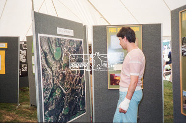
Negative - Photograph, Eltham Shire Council display, 1987 Eltham Community Festival, Alistair Knox Park, 7 Nov. 1987
... Eltham District Historical Society Inc 728 Main Rd Eltham ...Regular display by Council at the Eltham Festival providing ratepayers and visitors some insight into the daily operations of and services provided by Council and various equipment and machinery used.Roll of 35mm colour negative film, 4 stripsKodak GB 200 5096aerial photographs, alistair knox park, displays, eltham festival, eltham shire council, infrastructure, north warrandyte, shire of eltham -
 Eltham District Historical Society Inc
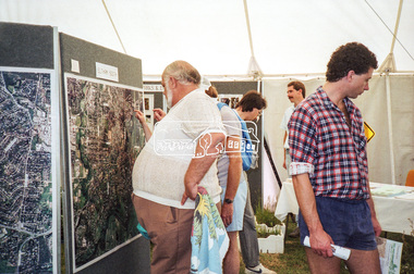
Negative - Photograph, Eltham Shire Council display, 1987 Eltham Community Festival, Alistair Knox Park, 7 Nov. 1987
... Eltham District Historical Society Inc 728 Main Rd Eltham ...Regular display by Council at the Eltham Festival providing ratepayers and visitors some insight into the daily operations of and services provided by Council and various equipment and machinery used.Roll of 35mm colour negative film, 4 stripsKodak GB 200 5096aerial photographs, alistair knox park, displays, eltham festival, eltham shire council, infrastructure, shire of eltham, eltham south -
 Eltham District Historical Society Inc
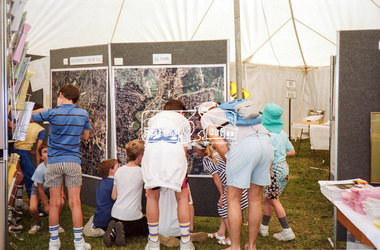
Negative - Photograph, Eltham Shire Council display, 1987 Eltham Community Festival, Alistair Knox Park, 7 Nov. 1987
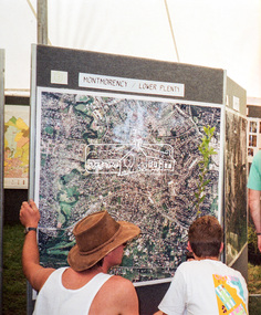
... display, 1987 Eltham Community Festival, Alistair Knox Park ...Regular display by Council at the Eltham Festival providing ratepayers and visitors some insight into the daily operations of and services provided by Council and various equipment and machinery used.Roll of 35mm colour negative film, 4 stripsKodak GB 200 5096aerial photographs, alistair knox park, displays, eltham festival, eltham shire council, infrastructure, shire of eltham, briar hill, eltham, montmorency -
 Eltham District Historical Society Inc
Negative - Photograph, Eltham Shire Council display, 1987 Eltham Community Festival, Alistair Knox Park, 7 Nov. 1987
... Eltham Community Festival, Alistair Knox Park Negative Photograph ...Regular display by Council at the Eltham Festival providing ratepayers and visitors some insight into the daily operations of and services provided by Council and various equipment and machinery used.Roll of 35mm colour negative film, 4 stripsKodak GB 200 5096aerial photographs, alistair knox park, displays, eltham festival, eltham shire council, infrastructure, shire of eltham, montmorency, lower plenty -
 Eltham District Historical Society Inc
Negative - Photograph, Eltham Shire Council display, 1987 Eltham Community Festival, Alistair Knox Park, 7 Nov. 1987
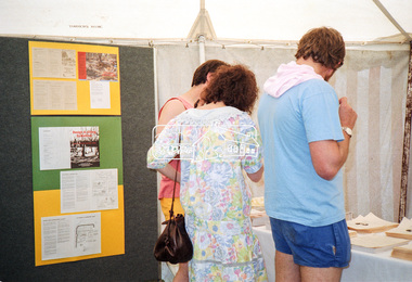
... knox park Building Construction Eltham Festival Eltham Shire ...Regular display by Council at the Eltham Festival providing ratepayers and visitors some insight into the daily operations of and services provided by Council and various equipment and machinery used.Roll of 35mm colour negative film, 4 stripsKodak GB 200 5096infrastructure, shire of eltham, displays, alistair knox park, building construction, eltham festival, eltham shire council, houses -
 Eltham District Historical Society Inc
Document - Series Listing, Fraser Faithfull et al, Series 52: Ari in Public Places Awards 1992 & 1994, photographs, 2000
Series consists of one folder of photographs relating to Art in Public Places awards. The folder is divided into two parts: I) Presentation and Installation - 1992 Award. Colour prints featuring Shire President Pamela Sladden opening "The Tower" at Weir St Park, Montmorency. Also pictured are Shire Arts officers Caroline Shaw and Chris Marks. Folder includes: * B& W and colour photographs taken on the night of the award presentation. * Four colour photographs of Weir St Park prior to installation of tower. * Colour photographs of two alternative sites for installation of tower. 2) Selection of 18 colour photographs taken at Selection Night for the 1994 Art in Public Places award. This event took place in the new Eltham Library. Also included arc panels of32 photographs (colour and B&W) of Alistair Knox Park and the immediate area around the new Eltham Library - photocopies of these pictures were provided to artists to give them a feel for the area. Note that selection took place after the commencement of the Nillumbik Shire Council, possibly in 1995.shire of eltham archives, series listing -
 Eltham District Historical Society Inc
Document - Series Listing, Fraser Faithfull et al, Series 55: Art in Public Places Awards 1992 & 1994, photographic negatives, 2000
Series consists of: * 59 colour and 21 B&W negatives taken on the night of the award presentation and at Weir St Park in Montmorency. * 24 colour negatives from 1994 ceremony.shire of eltham archives, series listing -
 Eltham District Historical Society Inc
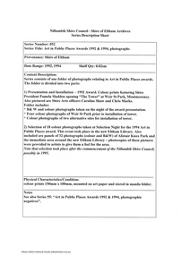
Document - Series Listing, Fraser Faithfull et al, Series 61: Shire Scenes / Activities / Staff, negatives, 2000
Series consists of a large collection (over 1150) of negatives of scenes, activities and staff of the Shire of Eltham. Many of the films were taken for publicity purposes and necessarily cover a broad range of topics. The films or individual strips have been organised into Scenes, Activities and Staff groupings, however there are many overlaps. 1) Scenes includes: Parks and Roads including Alistair Knox Park, Tree Planting, Trees and Flowers, general Shire Scenes. One of the Alistair Knox Park films also contains shots of the Shire President (John Graves?) in the Chambers wearing the Presidential Chain. 375 negatives. 2) Activities documented include: Fire Safety workshop and massage, Leisure Centre activities including pool construction, Living and Learning Centre, Pottery, Netball, Shire Offices, Elderly Citizens, Buildings, Youth Services, Sporting Facilities, Parklands, Community Arts, Childca re, Childrens Week Book Launch 23/ 10/1991 , Environment Week Launch 19/9/1991 , Childrens Services and Activities, Buy A Book Campaign Launch November 1990, Thelma Barkways' Birthday 1990, Engineering activities including Waste Collection, Building and Health Services activities including water testing, examples of new housing, blocks of land, letter box numbers. Also in this section are Shire Office and Handbook shots, nature shots including butterflies (Eltham Copper Butterfly?), wheelchairbound CEO Rodney Roscholler, Community Services Xmas Lunch 1991. 607 negatives. 3) Staff including many groups and individuals to be identified, Rodney Roscholler, Thelma Barkway, Councillors, Shire President Pamela Sladden, Roma O'Callaghan, Irene in the Kitchen/Entertainment Area, also Farm Scenes. 169 negatives.shire of eltham archives, series listing -
 Eltham District Historical Society Inc
Document - Series Listing, Fraser Faithfull et al, Series 63: Shire Staff and Activities photographs, arranged by Department, 2000
... ) Planning and Parks shire of eltham archives series listing A4 ...Several hundred photographs of Shire staff at work, training, sporting and social functions. Where possible the photographs have been arranged into five Departmental groups, ie: Community Services Building and Health Services Engineering Administration & Finance (including staff groups, executive staff, Council receptions, dinners, Christmas parties, sports events) Planning and Parksshire of eltham archives, series listing -
 Eltham District Historical Society Inc
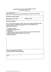
Slide, Shire of Eltham War Memorial Tower, Eltham-Yarra Glen Road, Kangaroo Ground, 24 Jul 1973
... . The Memorial Park and Shire of Eltham War Memorial tower are sited.... The Memorial Park and Shire of Eltham War Memorial tower are sited ...Various views from each side of the tower lookout. The Memorial Park and Shire of Eltham War Memorial tower are sited at was once known as Garden Hill and was reknowned for its panoramic views it offered tourists from the 1880s on. It was claimed that the full extent of the former Shire of Eltham could be looked upon from this viewpoint - and extending beyond.35 mm colour positive transparency x 7 Mount - Agfacolor Service (Blue)kangaroo ground, shire of eltham, war memorial tower, eltham-yarra glen road, shire of eltham war memorial -
 Eltham District Historical Society Inc
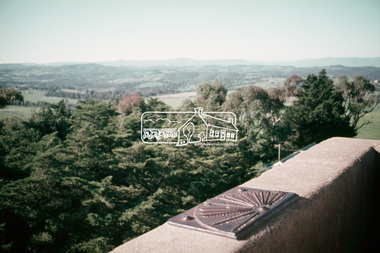
Slide, Memorial Park facilities, Shire of Eltham War Memorial, Kangaroo Ground, 24 Jul 1973
... Memorial Park facilities, Shire of Eltham War Memorial... (Blue) Memorial Park facilities, Shire of Eltham War Memorial ...The toilet block facilities for the park and war memorial were constructed in 196535 mm colour positive transparency Mount - Agfacolor Service (Blue)kangaroo ground, shire of eltham, war memorial tower, eltham-yarra glen road, shire of eltham war memorial -
 Eltham District Historical Society Inc
Slide, Pryor Street, Eltham, 25 Jul 1973
... is now a busy shopping centre car park. eltham eltham police ...Looking east across Pryor Street towards the Eltham Police Station. The Police purchased the residence at 23 Pryor Street in 1959 to move from the old town centre of the late 1800s to be closer to the new town centre that shifted as a result of the railway opening in 1901. The residential house was renovated to Police requirements and operations commenced from this location in 1961. Diretly opposite and to the left of the Police Station is now a busy shopping centre car park.35 mm colour positive transparency Mount - Agfacolor Service (Blue)eltham, eltham police station, pryor street, streets, houses -
 Eltham District Historical Society Inc
Slide, Site of proposed Yarra Brae Dam, Jul. 1973
With an increasing need to grow Melbourne's water supply, in 1973, the State Government announced plans for the development of Sugarloaf Reservoir. Two dams were to be built, one across the Yarra from the Yarra Brae property in Wonga Park to the Bend of Isles. Water was to be pumped from this dam to the higher level Sugarloaf Reservoir. The proposed extensive flooding of large numbers of properties resulted in significant community backlash and ultimately abandonement of the proposed Yarra Brae dam.35 mm colour positive transparency (x 3) Mount - Kodak Kodachrome Cardyarra brae dam -
 Eltham District Historical Society Inc
Slide, Maroondah Aqueduct, Research, Victoria, 22 Mar. 1981
An inspection tour of the Maroondah Aqueduct was undertaken by the Shire of Eltham Historical Society on Sunday, March 22nd, 1981, commening where the aqueduct crosses Main Rd., Research, just below Eltham College. The Maroondah Aqueduct was part of Melbourne’s water supply system. It carried water over the 66 km from the Maroondah Reservoir on the Watts River at Healesville to the Preston Reservoir. Of this length, 41 km were open channel, 10 km, tunnel through hills and 15 km in 14 inverted siphons across stream valleys. The route of the aqueduct is north of Tarrawarra and Yarra Glen, along the Yarra escarpment south of Christmas Hills and crossing Watsons Creek into the present Shire of Eltham near Henley Rd. The eastern part of the route lies entirely within the former boundaries of the shire. The aqueduct passes south of Kangaroo Ground to Research and crosses the Diamond Creek by siphon at Allendale Rd., Eltham North. It then extends to Reservoir via St. Helena, Greensborough North and Bundoora. Water first flowed through the aqueduct in February 1891 when it was fed by a diversion weir on the Watts River. Records of the building of the aqueduct indicate that it was a significant construction achievement. The present Maroondah Reservoir was completed in 1927 and the aqueduct was enlarged at that time to take increased flows. About 1971 the section of the aqueduct through and north of Research was replaced by a large pipe and that section of the channel is now unused. The channel has remained largely intact (unlike sections at Greensborough and Bundoora where long lengths of the disused aqueduct have been demolished or filled in). The M.M.B.W. relinquished control of the disused aqueduct reserve which is crown land and the Shire of Eltham took control of this section of the reserve as a linear park. The Maroondah Aqueduct is considered to be an important historic structure, not just to the local area but to the metropolitan area generally. It is considered important to preserve substantially intact long lengths of the disused aqueduct, together with its bridges and other associated structures. 35 mm colour positive transparency (1 of 5) Mount - Agfachrome Agfa CS System black 8 dotsactivities, heritage excursion, maroondah aqueduct, research (vic.), shire of eltham historical society -
 Eltham District Historical Society Inc
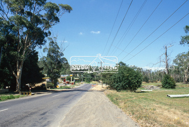
Slide, Main Road, Eltham South, Nov. 1981
Roll of film taken by Eltham Shire Council officers (Nov. 1981) reflecting road infrastructure. Golden Fleece Service Station on left now the Shell/Coles Express. On right is Bremner's Flats where the original Eltham tennis courts were siutaed at the turn of the 20th century and where the circus would be located in the 1950s and 1960s; now Wingrove Park35 mm colour positive transparency (1 of 27) Mount - Kodak Ektachrome CardProcessed 18 Jan 1982infrastructure, main road, roads, bremner's flat, construction, eltham south, golden fleece service station, mount pleasant road, wingrove park -
 Eltham District Historical Society Inc
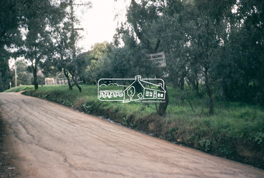
Photograph, Beard Street, Eltham, 3 Sep 1981
... Eltham District Historical Society Inc 728 Main Rd Eltham ...Roll of film taken by Eltham Shire Council officers of roads and houses in the Eltham East area, 3 September 1981 prior to construction of new water main; including views of existing damage to footpaths and gutters and general views of Beard Street. These images provide a perspective of housing estate developments and changes in housing styles and road development which began sweeping in from the mid 1970s with increasing urbanisation of what was once more outlying suburbs and regions.35mm colour positive transparency (1 of 28) Mount - Kodak Kodachrome Cardbeard street, eltham, infrastructure, roads, horse, park road -
 Eltham District Historical Society Inc
Photograph, Madine Way, Eltham, 3 Sep 1981
Roll of film taken by Eltham Shire Council officers of roads and houses in the Eltham East area, 3 September 1981 prior to construction of new water main; including views of existing damage to footpaths and gutters and general views of Beard Street. These images provide a perspective of housing estate developments and changes in housing styles and road development which began sweeping in from the mid 1970s with increasing urbanisation of what was once more outlying suburbs and regions.35mm colour positive transparency (1 of 28) Mount - Kodak Kodachrome Cardeltham, infrastructure, roads, madine way, tadema park -
 Eltham District Historical Society Inc
Photograph, Water Main Pipe Track (Madine Way-Eucalyptus Road), Eltham, 3 Sep 1981
Roll of film taken by Eltham Shire Council officers of roads and houses in the Eltham East area, 3 September 1981 prior to construction of new water main; including views of existing damage to footpaths and gutters and general views of Beard Street. These images provide a perspective of housing estate developments and changes in housing styles and road development which began sweeping in from the mid 1970s with increasing urbanisation of what was once more outlying suburbs and regions.35mm colour positive transparency (1 of 28) Mount - Kodak Kodachrome Cardeltham, infrastructure, roads, water main pipe track, madine way, eucalyptus road, tadema park -
 Eltham District Historical Society Inc
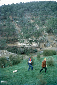
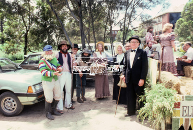
Photograph, Grand Parade, Eltham Community Festival, 17 Nov. 1984
... festival parade parade floats Central Park doug orford Eltham Shire ...The Society again arranged a float for the festival parade. Members dressed appropriately to the theme "Pioneers of Eltham". The parade commenced at 12 noon, participants assembling at 11.30am in Cecil Street. As in past parades, several members of the Victorian Folk Music Club accompanied the Society. The Society also arranged a display at the Eltham Community Centre in association with the activities there over the Festival weekend. The theme of this year's display was the waterways of the local area.35mm colour positive transparency Mount - Kodak Kodachrome Cardeltham, eltham festival, parade, parade floats, central park, doug orford, eltham shire office, garnet burges, joh ebeli, opal smith, panther place, peter bassett smith, peter bassett-smith, russell yeoman, victorian folk music society -
 Eltham District Historical Society Inc
Photograph, Panton Hill Memorial Park, c.May 1988
35mm colour positive transparency (1 of 25) Mount - Kodak EktachromeProcess Date MAY 88Mpanton hill memorial park -
 Eltham District Historical Society Inc
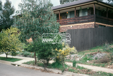
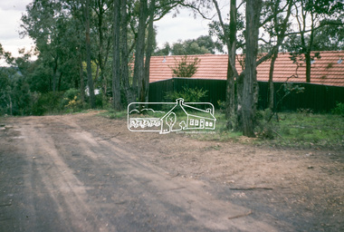
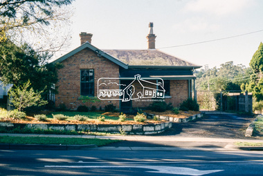
Slide - Photograph, Shire of Eltham, Parks & Environment, 728 Main Road, Eltham, c.May 1988
... . It was then occupied by the Eltham Shire Council Department of Parks ...Originally built 1859 as the Eltham Police Residence, the Police moved intio new premises in Pryor Street in 1961. It was then occupied by the Eltham Shire Council Department of Parks and Environment from c.1985. In 1998 it became home of the Eltham District Historical Society.35mm colour positive transparency (1 of 23) Mount - Kodak EktachromeProcess Date MAY 88Meltham, local history centre, main road, parks and environment, police residence, shire of eltham