Showing 1645 items
matching fill
-
 Federation University Historical Collection
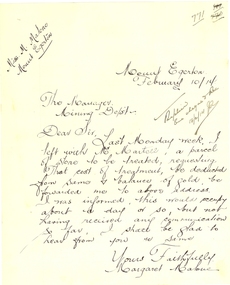
Letter - Correspondence, Margaret Malone, Letter regarding gold assay from Mount Egerton Mine, 10/02/2014
Margaret Malone was associated with a kaolin mine at Mount Egerton. WOMAN WHO MANAGES A MINE Works With A Vision (By a Special Corespondent) BALLARAT, August 22.—Like a Heroine in a Bret Harte story of the Soaring: Forties Miss Margaret Malone, the only woman mine manager in Australia, has lived most of her life in an atmosphere where hope springs eternal in the gold-seeking breast. Forty years ago her father gave up farming to seek the elusive mineral near Ballarat. "One day my mother went for a walk along the Gordon-Egerton road and picked up a pebble with a few specks of gold in it," she told an interviewer yesterday, recounting the early history of the nine she now runs at Egerton. "Dad said, There must be more where that came from,' and hopefully sank a shaft. Our hopes were dashed, however, when he found only white clay. No one realised then the value of the disappointing looking white stuff which was all that Dad could find from every shaft he sank. At last be gave up the search, and the kaolin remained untouched." Later an Englishman from a pottery town in the old country urged Mr. Malone to try and sell his clay, and he sent some to the Bendigo potteries, but nothing came of it, and it was left to Miss Malone, after her father's death, to start on her unusual career by finding purchasers in Sydney and Melbourne for her clay, and herself working the mine. Strenuous Work "Mine managing is strenuous work in more ways than one," she admitted. "I have, to go down my mine daily, ad sometimes have to descend perpendicular ladders for about 150 ft. to reach areas being worked. I have to be my own manager, she explained, "because it is necessary to teach the men I employ the methods of grading clays." A New Cure She is convinced that a number of uses for kaolin, apart from pottery, soap and drugs, are yet to be discovered. "One of my employees has already found a new use for it," she said, "although scarcely one to be generally recommended, perhaps. By chewing a small piece of the clay he firmly believes that he "cured himself of heart burn." "All That Glistens" There is more in Miss Malone's mining than meets the eye, however. The actual working of the field and the substantial profit she makes on it do not fill her days. Always before her - dangles the compelling vision that caused her father, in his day, to give up farming to seek for gold. "All the time I am getting my clay dug," she confessed, "1 am watching for the colour of gold. One of these days I may strike it." WOMAN WHO MANAGES A MINE Works With A Vision (By a Special Corespondent) BALLARAT, August 22.—Like a Heroine in a Bret Harte story of the Soaring: Forties Miss Margaret Malone, the only woman mine manager in Australia, has lived most of her life in an atmosphere where hope springs eternal in the gold-seeking breast. Forty years ago her father gave up farming to seek the elusive mineral near Ballarat. "One day my mother went for a walk along the Gordon-Egerton road and picked up a pebble with a few specks of gold in it," she told an interviewer yesterday, recounting the early history of the nine she now runs at Egerton. "Dad said, There must be more where that came from,' and hopefully sank a shaft. Our hopes were dashed, however, when he found only white clay. No one realised then the value of the disappointing looking white stuff which was all that Dad could find from every shaft he sank. At last be gave up the search, and the kaolin remained untouched." Later an Englishman from a pottery town in the old country urged Mr. Malone to try and sell his clay, and he sent some to the Bendigo potteries, but nothing came of it, and it was left to Miss Malone, after her father's death, to start on her unusual career by finding purchasers in Sydney and Melbourne for her clay, and herself working the mine. Strenuous Work "Mine managing is strenuous work in more ways than one," she admitted. "I have, to go down my mine daily, ad sometimes have to descend perpendicular ladders for about 150 ft. to reach areas being worked. I have to be my own manager, she explained, "because it is necessary to teach the men I employ the methods of grading clays." A New Cure She is convinced that a number of uses for kaolin, apart from pottery, soap and drugs, are yet to be discovered. "One of my employees has already found a new use for it," she said, "although scarcely one to be generally recommended, perhaps. By chewing a small piece of the clay he firmly believes that he "cured himself of heart burn." "All That Glistens" There is more in Miss Malone's mining than meets the eye, however. The actual working of the field and the substantial profit she makes on it do not fill her days. Always before her - dangles the compelling vision that caused her father, in his day, to give up farming to seek for gold. "All the time I am getting my clay dug," she confessed, "1 am watching for the colour of gold. One of these days I may strike it." (WOMAN WHO MANAGES A MINE Works With A Vision (By a Special Corespondent) BALLARAT, August 22.—Like a Heroine in a Bret Harte story of the Soaring: Forties Miss Margaret Malone, the only woman mine manager in Australia, has lived most of her life in an atmosphere where hope springs eternal in the gold-seeking breast. Forty years ago her father gave up farming to seek the elusive mineral near Ballarat. "One day my mother went for a walk along the Gordon-Egerton road and picked up a pebble with a few specks of gold in it," she told an interviewer yesterday, recounting the early history of the nine she now runs at Egerton. "Dad said, There must be more where that came from,' and hopefully sank a shaft. Our hopes were dashed, however, when he found only white clay. No one realised then the value of the disappointing looking white stuff which was all that Dad could find from every shaft he sank. At last be gave up the search, and the kaolin remained untouched." Later an Englishman from a pottery town in the old country urged Mr. Malone to try and sell his clay, and he sent some to the Bendigo potteries, but nothing came of it, and it was left to Miss Malone, after her father's death, to start on her unusual career by finding purchasers in Sydney and Melbourne for her clay, and herself working the mine. Strenuous Work "Mine managing is strenuous work in more ways than one," she admitted. "I have, to go down my mine daily, ad sometimes have to descend perpendicular ladders for about 150 ft. to reach areas being worked. I have to be my own manager, she explained, "because it is necessary to teach the men I employ the methods of grading clays." A New Cure She is convinced that a number of uses for kaolin, apart from pottery, soap and drugs, are yet to be discovered. "One of my employees has already found a new use for it," she said, "although scarcely one to be generally recommended, perhaps. By chewing a small piece of the clay he firmly believes that he "cured himself of heart burn." "All That Glistens" There is more in Miss Malone's mining than meets the eye, however. The actual working of the field and the substantial profit she makes on it do not fill her days. Always before her - dangles the compelling vision that caused her father, in his day, to give up farming to seek for gold. "All the time I am getting my clay dug," she confessed, "1 am watching for the colour of gold. One of these days I may strike it." (Adelaide Observer, 31 August 1929.)Hand written letter from Margaret Malone of the Mount Egerton Mine.Mount Egerton Mine February 10/14 The Manager Mining Dept Dear Sir, Last Monday week, I left with Mr Martell, a parcel of stone to be treated, requesting that cost of treatment, be deducted from some and balance of gold be forwarded me to above address. I was informed, this would occupy about a day or so, but not having received any communication so far, I shall be glad to hear from you are same. Yours faithfully Margaret Malonemargaret malone, female mine manager, kaolin, mount egerton, women -
 Warrnambool RSL Sub Branch
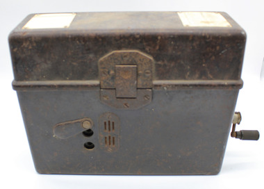
WW2 Field Telephone/Communication Instrument; German
Used in WW2. Basically of german origin and manufacture but 'English' handset suggests capture and use by Australian forces possibly in Middle East Desert warfare.Black Rectangular Metal Box with Lid. Total Height 215mm (with lid closed), Body Height 140mm. Lid Height 75mm.Lid attached by full length Hinge on rear and locking Clip at front.Depth 90mm. Length 275mm. Lid Outside: has overlapping lip to body when closed.Reinforcing metal attachment on left side rolls over to inside of lid and is attached by two screws. Front locking clip is spring loaded and attached to lid by 3 screws. Lid Inside: Flexible metal plate to clip on handset. 2 inscription plates on left and right ends and telephone handset described separately Body Outside:Front: 2 Jack plug points, vertically aligned 85mm from left, 25mm apart either side of mid point of height of bodyprotedted by protective pivot plate. Air vent plate attached with 2 screws adjacent to Jack plug holes (same on Back). Left side at top; metal plate for carry strap (same on right side). carry strap not with item.Right side; hole covered by protective cover plate centred 70mm from base , Wind-Up handle attached (described seoarately. Body Inside: 2/3 filled with visible metal and bakelite components in separate compartment containing unseen working parts. Left side contains morse code key in canvas bag (described separately). Contents Inside Lid. Two schematics of wiring layouts attached to left and right ends. Removable Bakelite handset clipped into postion for carrying, attached cable has 4-pronged attachment connected to main section in body. Contents Inside Body. Most working parts hidden inside metal container. White plastic button 'Pruttaste' is a test button; threaded screws on top for attachments not present.Two pieces of loose wire purpose unknown. Canvas Bag with zip, labelled DD with arrow between (Department of Defence) containing Morse Code Key; wire with large jackplug attachment connected to MC Key through the bag. Jackplug connects via front of body of object. The whole of this item is stored in left inside of body.underside of handset says PRESS KEY WHILE SPEAKING and in smaller font size TELE HD NO 2 -
 Flagstaff Hill Maritime Museum and Village
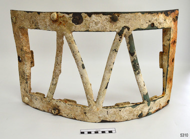
Functional object - Skylight frame, Alexander Stephen and Sons, 1869
This skylight frame would have been fitted on the Newfield’s poop deck (or raised deck that forms the roof of a cabin at the aft or rear of the ship). It would have covered and protected a glass pane that allowed light to enter the area below desk. The glass pane from the skylight is missing. The Newfield was a three-masted iron and steel barque, built in Dundee, Scotland, in 1869 by Alexander Stephen and Sons. It was owned by the Newfield Ship Company in 1890 and later that year It was registered in Liverpool to owners Brownells and Co. The Newfield left Sharpness, Scotland, on 28th May 1892 with a crew of 25 under the command of Captain George Scott and on 1st June left Liverpool. She was bound for Brisbane, Australia, with a cargo of 1850 tons of fine rock salt. On the night of 28 August 1892, the Captain mistook the Cape Otway light for that of Cape Wickham (King Island) and altered tack to the north and east putting the vessel on a collision course with the Victorian coast. At around 3:40 am the Newfield struck rocks about 100 yards from shore, and 5 feet of water filled the holds immediately. The captain gave orders to lower the boats which caused a disorganised scramble for safety among the crew. The starboard lifeboat was cleared for lowering with two seamen and two apprentices in her, but almost as soon as she touched the water she was smashed to bits against the side of the vessel, and only one of the four reached safety ashore, able seaman McLeod. The rough sea made the job of launching lifeboats very difficult. The first two lifeboats launched by the crew were smashed against the side of the ship and some men were crushed or swept away. The third lifeboat brought eight men to shore. It capsized when the crew tried to return it to the ship for further rescue The rescue was a difficult operation. The Port Campbell Rocket Crew arrived and fired four rocket lines, none of which connected with the ship. Peter Carmody, a local man, volunteered to swim about one mile offshore to the ship with a line to guide the fourth and final lifeboat safely to shore. He was assisted by James McKenzie and Gerard Irvine. Seventeen men survived the shipwreck but the captain and eight of his crew perished. The Newfield remained upright on the reef with sails set for a considerable time as the wind slowly ripped the canvas to shreds and the sea battered the hull to pieces. The Marine Board inquiry found the wreck was caused by a "one-man style of navigation" and that the Captain had not heeded the advice of his crew. For his heroic efforts, Peter Carmody was awarded the Bramley-Moore medal by the Liverpool Shipwreck and Humane Society for Saving Life at sea on January 21st 1893. The medal and a letter of congratulations were donated to Flagstaff Hill Maritime Museum by Peter Carmody's granddaughter Norma Bracken and her son Stuart Bracken on 25th May 2006. Flagstaff Hill’s collection of artefacts from the Newfield is significant for its association with the shipwreck Newfield, which is listed on the Victorian Heritage Registry. The collection is additionally significant because of the medal awarded to a local man Peter Carmody. The Newfield collection historically also represents aspects of Victoria's shipping history and its association with the shipwreck.Skylight, frame only. The heavily encrusted brass framework has eight bolts around the long side, and four metal bars forming two ‘v’ shapes across the centre. The frame is, slightly concave towards the inner side. The shorter ends of the frame each have a ‘U’ shaped bracket attached in the centre. The shorter ends are wider on one end and taper towards the other end to about a quarter of the thickness. The frame was recovered from the wreck of the NEWFIELD.Noneflagstaff hill maritime museum, newfield ship wreck, alexander stephen & sons, brownells & co, captain george scott, great ocean road ship wreck, peter carmody, bramley-moore medal, liverpool shipwreck and humane society, skylight cover, skylight frame, ship fitting, light cover, newfield -
 Eltham District Historical Society Inc
Photograph, Hume and Hovell Monument, Broadford, Autumn Excursion, Hume and Hovell's 1824 expedition, 26 May 1996, 26/05/1996
[article by Bettina Woodburn in EDHS Newsletter No. 109, July 1996:] ON THE TRAIL OF HUME AND HOVELL - REPORT ON THE AUTUMN EXCURSION - On a green and fresh morning (Sunday 26th May 1996) the Cobb and Co coach (driven by the most obliging Peter Tampion) set off in a north easterly direction from Eltham to connect with Hume and Hovell's route on their 1824 explorations of central Victoria. The Society would follow a series of monuments erected for the 1924 centenary of the expedition from King Parrot Creek (Tuesday 7th December 1824), through Strath Creek, over Sunday Creek (Sunday 12th December 1824) at Broadford, Tullamarine, St Albans, Deer Park, through Werribee, skirting east of the You Yangs to Lara and Avalon Beach. Because their distance-measuring wheel had broken and a one degree mistake was made in calculations, the two leaders of the original group of six convict-companions arrived at Corio Bay, instead of the expected Western Port, discovered earlier by Flinders. From below Mt. Disappointment (Hume and Hovell's difficulties in "scrambling over brush and rock", "leeches in forest, as well as no water", "cutting grass 4-5 ft. high", dreadful scrub", "devil flies") we took an easier route, saw the Strath Creek memorial in ground fog and a wonderful "field of dreams", the Hume-Hovell privately owned cricket ground with its white picket boundary fence. Now, after a steep climb, in sunshine under gums we stretched and viewed magnificent rolling hills and fog-filled valleys - not "smoke from Aborigines' bush fires". After morning tea at Broadford we followed the Sunday Creek valley beside the Hume Freeway, passed the Wallan Wallan Rest Area (more appropriately Hume and Hovell Rest Area) to tum right at Beveridge. In Gellibrand Hill Park, near the headwaters of the Moonee Ponds Creek, we experienced the landscape the first European settlers saw - huge river red gums and rolling pastures. The gardens and sheltered courtyard of the 1840s, timber, brought from .....[?] prefabricated Woodlands Homestead, provided a pleasant lunch stop. We enjoyed a private tour, panoramic views over Melbourne and surroundings and the excitement of arriving and departing aircraft. Our next river crossing was at Werribee, "in a vast treeless plain", then we drove on by-ways no coach had previously travelled, to find "an immense sheet of water" salty Corio Bay, off-course to the west. In late afternoon of a super, calm, late autumn day we headed homewards. Back at Eltham we were rather surprised to find that we had travelled a total of 347 km. Thanks again to Russell Yeoman for his research and organization. What a wonderful day! Colour photographactivities, broadford, hume and hovell, monument -
 Eltham District Historical Society Inc
Photograph, Strath Creek, Autumn Excursion, Hume and Hovell's 1824 expedition, 26 May 1996, 26/05/1996
[article by Bettina Woodburn in EDHS Newsletter No. 109, July 1996:] ON THE TRAIL OF HUME AND HOVELL - REPORT ON THE AUTUMN EXCURSION - On a green and fresh morning (Sunday 26th May 1996) the Cobb and Co coach (driven by the most obliging Peter Tampion) set off in a north easterly direction from Eltham to connect with Hume and Hovell's route on their 1824 explorations of central Victoria. The Society would follow a series of monuments erected for the 1924 centenary of the expedition from King Parrot Creek (Tuesday 7th December 1824), through Strath Creek, over Sunday Creek (Sunday 12th December 1824) at Broadford, Tullamarine, St Albans, Deer Park, through Werribee, skirting east of the You Yangs to Lara and Avalon Beach. Because their distance-measuring wheel had broken and a one degree mistake was made in calculations, the two leaders of the original group of six convict-companions arrived at Corio Bay, instead of the expected Western Port, discovered earlier by Flinders. From below Mt. Disappointment (Hume and Hovell's difficulties in "scrambling over brush and rock", "leeches in forest, as well as no water", "cutting grass 4-5 ft. high", dreadful scrub", "devil flies") we took an easier route, saw the Strath Creek memorial in ground fog and a wonderful "field of dreams", the Hume-Hovell privately owned cricket ground with its white picket boundary fence. Now, after a steep climb, in sunshine under gums we stretched and viewed magnificent rolling hills and fog-filled valleys - not "smoke from Aborigines' bush fires". After morning tea at Broadford we followed the Sunday Creek valley beside the Hume Freeway, passed the Wallan Wallan Rest Area (more appropriately Hume and Hovell Rest Area) to tum right at Beveridge. In Gellibrand Hill Park, near the headwaters of the Moonee Ponds Creek, we experienced the landscape the first European settlers saw - huge river red gums and rolling pastures. The gardens and sheltered courtyard of the 1840s, timber, brought from .....[?] prefabricated Woodlands Homestead, provided a pleasant lunch stop. We enjoyed a private tour, panoramic views over Melbourne and surroundings and the excitement of arriving and departing aircraft. Our next river crossing was at Werribee, "in a vast treeless plain", then we drove on by-ways no coach had previously travelled, to find "an immense sheet of water" salty Corio Bay, off-course to the west. In late afternoon of a super, calm, late autumn day we headed homewards. Back at Eltham we were rather surprised to find that we had travelled a total of 347 km. Thanks again to Russell Yeoman for his research and organization. What a wonderful day! Colour photographactivities, monument, hume and hovell, murchison valley, strath creek -
 Eltham District Historical Society Inc
Photograph, Murchison Gap viewed from Strath Creek, Autumn Excursion, Hume and Hovell's 1824 expedition, 26 May 1996, 26/05/1996
[article by Bettina Woodburn in EDHS Newsletter No. 109, July 1996:] ON THE TRAIL OF HUME AND HOVELL - REPORT ON THE AUTUMN EXCURSION - On a green and fresh morning (Sunday 26th May 1996) the Cobb and Co coach (driven by the most obliging Peter Tampion) set off in a north easterly direction from Eltham to connect with Hume and Hovell's route on their 1824 explorations of central Victoria. The Society would follow a series of monuments erected for the 1924 centenary of the expedition from King Parrot Creek (Tuesday 7th December 1824), through Strath Creek, over Sunday Creek (Sunday 12th December 1824) at Broadford, Tullamarine, St Albans, Deer Park, through Werribee, skirting east of the You Yangs to Lara and Avalon Beach. Because their distance-measuring wheel had broken and a one degree mistake was made in calculations, the two leaders of the original group of six convict-companions arrived at Corio Bay, instead of the expected Western Port, discovered earlier by Flinders. From below Mt. Disappointment (Hume and Hovell's difficulties in "scrambling over brush and rock", "leeches in forest, as well as no water", "cutting grass 4-5 ft. high", dreadful scrub", "devil flies") we took an easier route, saw the Strath Creek memorial in ground fog and a wonderful "field of dreams", the Hume-Hovell privately owned cricket ground with its white picket boundary fence. Now, after a steep climb, in sunshine under gums we stretched and viewed magnificent rolling hills and fog-filled valleys - not "smoke from Aborigines' bush fires". After morning tea at Broadford we followed the Sunday Creek valley beside the Hume Freeway, passed the Wallan Wallan Rest Area (more appropriately Hume and Hovell Rest Area) to tum right at Beveridge. In Gellibrand Hill Park, near the headwaters of the Moonee Ponds Creek, we experienced the landscape the first European settlers saw - huge river red gums and rolling pastures. The gardens and sheltered courtyard of the 1840s, timber, brought from .....[?] prefabricated Woodlands Homestead, provided a pleasant lunch stop. We enjoyed a private tour, panoramic views over Melbourne and surroundings and the excitement of arriving and departing aircraft. Our next river crossing was at Werribee, "in a vast treeless plain", then we drove on by-ways no coach had previously travelled, to find "an immense sheet of water" salty Corio Bay, off-course to the west. In late afternoon of a super, calm, late autumn day we headed homewards. Back at Eltham we were rather surprised to find that we had travelled a total of 347 km. Thanks again to Russell Yeoman for his research and organization. What a wonderful day! Colour photographactivities, hume and hovell, murchison valley, murchison gap, strath creek -
 Eltham District Historical Society Inc
Photograph, Autumn Excursion, Hume and Hovell's 1824 expedition, 26 May 1996, 26/05/1996
[article by Bettina Woodburn in EDHS Newsletter No. 109, July 1996:] ON THE TRAIL OF HUME AND HOVELL - REPORT ON THE AUTUMN EXCURSION - On a green and fresh morning (Sunday 26th May 1996) the Cobb and Co coach (driven by the most obliging Peter Tampion) set off in a north easterly direction from Eltham to connect with Hume and Hovell's route on their 1824 explorations of central Victoria. The Society would follow a series of monuments erected for the 1924 centenary of the expedition from King Parrot Creek (Tuesday 7th December 1824), through Strath Creek, over Sunday Creek (Sunday 12th December 1824) at Broadford, Tullamarine, St Albans, Deer Park, through Werribee, skirting east of the You Yangs to Lara and Avalon Beach. Because their distance-measuring wheel had broken and a one degree mistake was made in calculations, the two leaders of the original group of six convict-companions arrived at Corio Bay, instead of the expected Western Port, discovered earlier by Flinders. From below Mt. Disappointment (Hume and Hovell's difficulties in "scrambling over brush and rock", "leeches in forest, as well as no water", "cutting grass 4-5 ft. high", dreadful scrub", "devil flies") we took an easier route, saw the Strath Creek memorial in ground fog and a wonderful "field of dreams", the Hume-Hovell privately owned cricket ground with its white picket boundary fence. Now, after a steep climb, in sunshine under gums we stretched and viewed magnificent rolling hills and fog-filled valleys - not "smoke from Aborigines' bush fires". After morning tea at Broadford we followed the Sunday Creek valley beside the Hume Freeway, passed the Wallan Wallan Rest Area (more appropriately Hume and Hovell Rest Area) to tum right at Beveridge. In Gellibrand Hill Park, near the headwaters of the Moonee Ponds Creek, we experienced the landscape the first European settlers saw - huge river red gums and rolling pastures. The gardens and sheltered courtyard of the 1840s, timber, brought from .....[?] prefabricated Woodlands Homestead, provided a pleasant lunch stop. We enjoyed a private tour, panoramic views over Melbourne and surroundings and the excitement of arriving and departing aircraft. Our next river crossing was at Werribee, "in a vast treeless plain", then we drove on by-ways no coach had previously travelled, to find "an immense sheet of water" salty Corio Bay, off-course to the west. In late afternoon of a super, calm, late autumn day we headed homewards. Back at Eltham we were rather surprised to find that we had travelled a total of 347 km. Thanks again to Russell Yeoman for his research and organization. What a wonderful day! Colour photographactivities, hume and hovell -
 Eltham District Historical Society Inc
Photograph, Sign to Hume and Hovell Cricket Ground, at Allandale Road, Strath Creek, Autumn Excursion, Hume and Hovell's 1824 expedition, 26 May 1996, 26/05/1996
[article by Bettina Woodburn in EDHS Newsletter No. 109, July 1996:] ON THE TRAIL OF HUME AND HOVELL - REPORT ON THE AUTUMN EXCURSION - On a green and fresh morning (Sunday 26th May 1996) the Cobb and Co coach (driven by the most obliging Peter Tampion) set off in a north easterly direction from Eltham to connect with Hume and Hovell's route on their 1824 explorations of central Victoria. The Society would follow a series of monuments erected for the 1924 centenary of the expedition from King Parrot Creek (Tuesday 7th December 1824), through Strath Creek, over Sunday Creek (Sunday 12th December 1824) at Broadford, Tullamarine, St Albans, Deer Park, through Werribee, skirting east of the You Yangs to Lara and Avalon Beach. Because their distance-measuring wheel had broken and a one degree mistake was made in calculations, the two leaders of the original group of six convict-companions arrived at Corio Bay, instead of the expected Western Port, discovered earlier by Flinders. From below Mt. Disappointment (Hume and Hovell's difficulties in "scrambling over brush and rock", "leeches in forest, as well as no water", "cutting grass 4-5 ft. high", dreadful scrub", "devil flies") we took an easier route, saw the Strath Creek memorial in ground fog and a wonderful "field of dreams", the Hume-Hovell privately owned cricket ground with its white picket boundary fence. Now, after a steep climb, in sunshine under gums we stretched and viewed magnificent rolling hills and fog-filled valleys - not "smoke from Aborigines' bush fires". After morning tea at Broadford we followed the Sunday Creek valley beside the Hume Freeway, passed the Wallan Wallan Rest Area (more appropriately Hume and Hovell Rest Area) to tum right at Beveridge. In Gellibrand Hill Park, near the headwaters of the Moonee Ponds Creek, we experienced the landscape the first European settlers saw - huge river red gums and rolling pastures. The gardens and sheltered courtyard of the 1840s, timber, brought from .....[?] prefabricated Woodlands Homestead, provided a pleasant lunch stop. We enjoyed a private tour, panoramic views over Melbourne and surroundings and the excitement of arriving and departing aircraft. Our next river crossing was at Werribee, "in a vast treeless plain", then we drove on by-ways no coach had previously travelled, to find "an immense sheet of water" salty Corio Bay, off-course to the west. In late afternoon of a super, calm, late autumn day we headed homewards. Back at Eltham we were rather surprised to find that we had travelled a total of 347 km. Thanks again to Russell Yeoman for his research and organization. What a wonderful day! Colour photographactivities, hume and hovell, allandale road, strath creek -
 Eltham District Historical Society Inc
Photograph, Autumn Excursion, Hume and Hovell's 1824 expedition, 26 May 1996, 26/05/1996
[article by Bettina Woodburn in EDHS Newsletter No. 109, July 1996:] ON THE TRAIL OF HUME AND HOVELL - REPORT ON THE AUTUMN EXCURSION - On a green and fresh morning (Sunday 26th May 1996) the Cobb and Co coach (driven by the most obliging Peter Tampion) set off in a north easterly direction from Eltham to connect with Hume and Hovell's route on their 1824 explorations of central Victoria. The Society would follow a series of monuments erected for the 1924 centenary of the expedition from King Parrot Creek (Tuesday 7th December 1824), through Strath Creek, over Sunday Creek (Sunday 12th December 1824) at Broadford, Tullamarine, St Albans, Deer Park, through Werribee, skirting east of the You Yangs to Lara and Avalon Beach. Because their distance-measuring wheel had broken and a one degree mistake was made in calculations, the two leaders of the original group of six convict-companions arrived at Corio Bay, instead of the expected Western Port, discovered earlier by Flinders. From below Mt. Disappointment (Hume and Hovell's difficulties in "scrambling over brush and rock", "leeches in forest, as well as no water", "cutting grass 4-5 ft. high", dreadful scrub", "devil flies") we took an easier route, saw the Strath Creek memorial in ground fog and a wonderful "field of dreams", the Hume-Hovell privately owned cricket ground with its white picket boundary fence. Now, after a steep climb, in sunshine under gums we stretched and viewed magnificent rolling hills and fog-filled valleys - not "smoke from Aborigines' bush fires". After morning tea at Broadford we followed the Sunday Creek valley beside the Hume Freeway, passed the Wallan Wallan Rest Area (more appropriately Hume and Hovell Rest Area) to tum right at Beveridge. In Gellibrand Hill Park, near the headwaters of the Moonee Ponds Creek, we experienced the landscape the first European settlers saw - huge river red gums and rolling pastures. The gardens and sheltered courtyard of the 1840s, timber, brought from .....[?] prefabricated Woodlands Homestead, provided a pleasant lunch stop. We enjoyed a private tour, panoramic views over Melbourne and surroundings and the excitement of arriving and departing aircraft. Our next river crossing was at Werribee, "in a vast treeless plain", then we drove on by-ways no coach had previously travelled, to find "an immense sheet of water" salty Corio Bay, off-course to the west. In late afternoon of a super, calm, late autumn day we headed homewards. Back at Eltham we were rather surprised to find that we had travelled a total of 347 km. Thanks again to Russell Yeoman for his research and organization. What a wonderful day! Colour photographactivities, hume and hovell -
 Eltham District Historical Society Inc
Photograph, Murchison Gap, Autumn Excursion, Hume and Hovell's 1824 expedition, 26 May 1996, 26/05/1996
[article by Bettina Woodburn in EDHS Newsletter No. 109, July 1996:] ON THE TRAIL OF HUME AND HOVELL - REPORT ON THE AUTUMN EXCURSION - On a green and fresh morning (Sunday 26th May 1996) the Cobb and Co coach (driven by the most obliging Peter Tampion) set off in a north easterly direction from Eltham to connect with Hume and Hovell's route on their 1824 explorations of central Victoria. The Society would follow a series of monuments erected for the 1924 centenary of the expedition from King Parrot Creek (Tuesday 7th December 1824), through Strath Creek, over Sunday Creek (Sunday 12th December 1824) at Broadford, Tullamarine, St Albans, Deer Park, through Werribee, skirting east of the You Yangs to Lara and Avalon Beach. Because their distance-measuring wheel had broken and a one degree mistake was made in calculations, the two leaders of the original group of six convict-companions arrived at Corio Bay, instead of the expected Western Port, discovered earlier by Flinders. From below Mt. Disappointment (Hume and Hovell's difficulties in "scrambling over brush and rock", "leeches in forest, as well as no water", "cutting grass 4-5 ft. high", dreadful scrub", "devil flies") we took an easier route, saw the Strath Creek memorial in ground fog and a wonderful "field of dreams", the Hume-Hovell privately owned cricket ground with its white picket boundary fence. Now, after a steep climb, in sunshine under gums we stretched and viewed magnificent rolling hills and fog-filled valleys - not "smoke from Aborigines' bush fires". After morning tea at Broadford we followed the Sunday Creek valley beside the Hume Freeway, passed the Wallan Wallan Rest Area (more appropriately Hume and Hovell Rest Area) to tum right at Beveridge. In Gellibrand Hill Park, near the headwaters of the Moonee Ponds Creek, we experienced the landscape the first European settlers saw - huge river red gums and rolling pastures. The gardens and sheltered courtyard of the 1840s, timber, brought from .....[?] prefabricated Woodlands Homestead, provided a pleasant lunch stop. We enjoyed a private tour, panoramic views over Melbourne and surroundings and the excitement of arriving and departing aircraft. Our next river crossing was at Werribee, "in a vast treeless plain", then we drove on by-ways no coach had previously travelled, to find "an immense sheet of water" salty Corio Bay, off-course to the west. In late afternoon of a super, calm, late autumn day we headed homewards. Back at Eltham we were rather surprised to find that we had travelled a total of 347 km. Thanks again to Russell Yeoman for his research and organization. What a wonderful day! Three colour photographsactivities, murchison gap, murchison valley -
 Eltham District Historical Society Inc
Photograph, Hume and Hovell Monument, Broadford, Autumn Excursion, Hume and Hovell's 1824 expedition, 26 May 1996, 26/05/1996
[article by Bettina Woodburn in EDHS Newsletter No. 109, July 1996:] ON THE TRAIL OF HUME AND HOVELL - REPORT ON THE AUTUMN EXCURSION - On a green and fresh morning (Sunday 26th May 1996) the Cobb and Co coach (driven by the most obliging Peter Tampion) set off in a north easterly direction from Eltham to connect with Hume and Hovell's route on their 1824 explorations of central Victoria. The Society would follow a series of monuments erected for the 1924 centenary of the expedition from King Parrot Creek (Tuesday 7th December 1824), through Strath Creek, over Sunday Creek (Sunday 12th December 1824) at Broadford, Tullamarine, St Albans, Deer Park, through Werribee, skirting east of the You Yangs to Lara and Avalon Beach. Because their distance-measuring wheel had broken and a one degree mistake was made in calculations, the two leaders of the original group of six convict-companions arrived at Corio Bay, instead of the expected Western Port, discovered earlier by Flinders. From below Mt. Disappointment (Hume and Hovell's difficulties in "scrambling over brush and rock", "leeches in forest, as well as no water", "cutting grass 4-5 ft. high", dreadful scrub", "devil flies") we took an easier route, saw the Strath Creek memorial in ground fog and a wonderful "field of dreams", the Hume-Hovell privately owned cricket ground with its white picket boundary fence. Now, after a steep climb, in sunshine under gums we stretched and viewed magnificent rolling hills and fog-filled valleys - not "smoke from Aborigines' bush fires". After morning tea at Broadford we followed the Sunday Creek valley beside the Hume Freeway, passed the Wallan Wallan Rest Area (more appropriately Hume and Hovell Rest Area) to tum right at Beveridge. In Gellibrand Hill Park, near the headwaters of the Moonee Ponds Creek, we experienced the landscape the first European settlers saw - huge river red gums and rolling pastures. The gardens and sheltered courtyard of the 1840s, timber, brought from .....[?] prefabricated Woodlands Homestead, provided a pleasant lunch stop. We enjoyed a private tour, panoramic views over Melbourne and surroundings and the excitement of arriving and departing aircraft. Our next river crossing was at Werribee, "in a vast treeless plain", then we drove on by-ways no coach had previously travelled, to find "an immense sheet of water" salty Corio Bay, off-course to the west. In late afternoon of a super, calm, late autumn day we headed homewards. Back at Eltham we were rather surprised to find that we had travelled a total of 347 km. Thanks again to Russell Yeoman for his research and organization. What a wonderful day! Colour photographactivities, broadford, hume and hovell, monument -
 Eltham District Historical Society Inc
Photograph, Hume and Hovell Monument, Autumn Excursion, Hume and Hovell's 1824 expedition, 26 May 1996, 26/05/1996
[article by Bettina Woodburn in EDHS Newsletter No. 109, July 1996:] ON THE TRAIL OF HUME AND HOVELL - REPORT ON THE AUTUMN EXCURSION - On a green and fresh morning (Sunday 26th May 1996) the Cobb and Co coach (driven by the most obliging Peter Tampion) set off in a north easterly direction from Eltham to connect with Hume and Hovell's route on their 1824 explorations of central Victoria. The Society would follow a series of monuments erected for the 1924 centenary of the expedition from King Parrot Creek (Tuesday 7th December 1824), through Strath Creek, over Sunday Creek (Sunday 12th December 1824) at Broadford, Tullamarine, St Albans, Deer Park, through Werribee, skirting east of the You Yangs to Lara and Avalon Beach. Because their distance-measuring wheel had broken and a one degree mistake was made in calculations, the two leaders of the original group of six convict-companions arrived at Corio Bay, instead of the expected Western Port, discovered earlier by Flinders. From below Mt. Disappointment (Hume and Hovell's difficulties in "scrambling over brush and rock", "leeches in forest, as well as no water", "cutting grass 4-5 ft. high", dreadful scrub", "devil flies") we took an easier route, saw the Strath Creek memorial in ground fog and a wonderful "field of dreams", the Hume-Hovell privately owned cricket ground with its white picket boundary fence. Now, after a steep climb, in sunshine under gums we stretched and viewed magnificent rolling hills and fog-filled valleys - not "smoke from Aborigines' bush fires". After morning tea at Broadford we followed the Sunday Creek valley beside the Hume Freeway, passed the Wallan Wallan Rest Area (more appropriately Hume and Hovell Rest Area) to tum right at Beveridge. In Gellibrand Hill Park, near the headwaters of the Moonee Ponds Creek, we experienced the landscape the first European settlers saw - huge river red gums and rolling pastures. The gardens and sheltered courtyard of the 1840s, timber, brought from .....[?] prefabricated Woodlands Homestead, provided a pleasant lunch stop. We enjoyed a private tour, panoramic views over Melbourne and surroundings and the excitement of arriving and departing aircraft. Our next river crossing was at Werribee, "in a vast treeless plain", then we drove on by-ways no coach had previously travelled, to find "an immense sheet of water" salty Corio Bay, off-course to the west. In late afternoon of a super, calm, late autumn day we headed homewards. Back at Eltham we were rather surprised to find that we had travelled a total of 347 km. Thanks again to Russell Yeoman for his research and organization. What a wonderful day! Two colour photographsactivities, hume and hovell, monument -
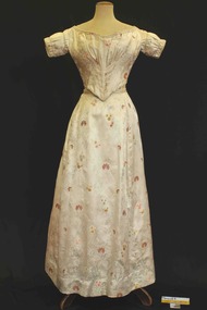
 Brighton Historical Society
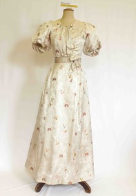
Clothing - Dress, Evening dress, circa 1890 (bodice), circa 1840 (skirt)
The donor and family of this gown were long-term Brighton residents, and the gowns were held by them as family heirlooms prior to donation to Brighton Historical Society. Originally owned by Elizabeth Emma Adams and Cecilia Elizabeth Adams, it is believed that the dress was brought to Australia by either a half brother, James Smith Adams, or a younger sister, Sophia Charlotte Louisa Adams (later known as Mother Rose Columba Adams). Elizabeth and Cecilia were the daughters of James Smith Adams (a squire, 1780-1860) and Elizabeth Emma McTaggart (1793-1843) of Tower House, Woodchester in Gloucester, a property which Elizabeth later inherited. Originally a monastery, Tower House had been converted into a stately home after the Reformation. According to information originally provided by the donor, the skirt portion of this dress (along with the bodice T0004.3) was made for either Elizabeth or Cecilia to be worn at the young Queen Victoria’s first 'drawing room ball' following the end of court mourning in 1838 for her uncle William IV who died in 1837. In 1838 Cecilia would have been twelve years old and Elizabeth would have been ten years old. It is possible that this dress was worn by one of the girls to this event as it is of appropriate dimensions for a child of that age, although its design is very formal and adult. Elizabeth was born on 30 June 1828 at Tower House and died on 1 May 1909. She created a scandal when she eloped with her first husband, Thomas Charles Gardiner at the age of 18. The validity of the marriage was later formally investigate and, while it was confirmed as valid, a second church wedding was subsequently held. Thomas died in 1878. Elizabeth subsequently remarried Reverend R. E. Blackwell, but was widowed again by 1889. Cecilia was born on 17 December 1826 and died in 1902 a spinster recluse in England. At the inquest into Cecelia's death in 1904 it was revealed that she had clearly come from a family of means as her home was filled to the brim with highly valuable goods, many in boxes. She was buried in the family vault at Woodchester. Elizabeth and Cecilia's sister Sophia converted to Roman Catholicism in 1851 and became a nun, taking the religious name 'Rose Columba'. In 1883 Mother Rose Columba led a group of eight to Australia, answering a call for Dominican sisters to nurse the sick in Adelaide. Upon arrival, she founded St. Dominic's Priory and the Church of Perpetual Adoration in North Adelaide, using her inheritance to build the chapel. Elizabeth's second son, George Henry Somerset, who inherited the Adams family estate dropped the 'i' in Gardiner and added the maiden name of his grandmother. Therefore, the family name has now become Gardner McTaggart. These Adams family entries have been updated with information provided by Dr Herbert Gardner McTaggart, great-grandson of George Henry Somerset in April 2016. Mr McTaggart contacted the society after finding our entries online.A hand and machine sewn cream, pale blue, orange and gold embroidered satin formal dress, the bodice dates from circa 1890. This dress shares a skirt with T0004.3, which dates from circa 1840. The bodice features a high scoop neckline with gathers at the base of the scoop and directly below where the bodice finishes creating fullness over the bust. The bodice front encloses the bust with a right panel over the top of a left panel and securing with two hook and eye closures over the left shoulder. The panels are secured together with 15 hook and eye closures. The sleeves are set neatly on the true shoulder and are elongated full puffs to just above the elbow. The fullness is created by nine pleats from the top of the shoulder over the back of the shoulder. At the base of the sleeve the fullness is gathered just above the elbow. At the centre back of the bodice are four inward facing pleats running from the centre neck to the waist. The bodice is secured around the waist with a tape and four hook and eye closures. The bodice is boned around the sides and back of the torso with eight bones. This bodice is finished at the waist with a pleated cummerbund of the dress fabric that is designed to appear to be a sash with two decorative bows. One front left of centre and one back right of centre. The skirt secures at the waist with an opening to the left of centre at the back. The skirt gathers tightly at the centre back with a dart on either side. The skirt has a front central panel and the skirt falls to floor length. At the back, the skirt is also floor length. The back of the skirt may have been modified at some time and may have originally finished in a train. It would be more appropriate to the period of the bodice, and the believed use of the dress with a train.cecilia elizabeth adams, elizabeth emma adams, queen victoria, tower house, woodchester, james smith adams, elizabeth emma mctaggart, sophia charlotte louisa adams, 1890s fashion -
 Brighton Historical Society
Clothing - Dress, Evening dress, circa 1840
The donor and family of this gown were long-term Brighton residents, and the gowns were held by them as family heirlooms prior to donation to Brighton Historical Society. Originally owned by Elizabeth Emma Adams and Cecilia Elizabeth Adams, it is believed that the dress was brought to Australia by either a half brother, James Smith Adams, or a younger sister, Sophia Charlotte Louisa Adams (later known as Mother Rose Columba Adams). Elizabeth and Cecilia were the daughters of James Smith Adams (a squire, 1780-1860) and Elizabeth Emma McTaggart (1793-1843) of Tower House, Woodchester in Gloucester, a property which Elizabeth later inherited. Originally a monastery, Tower House had been converted into a stately home after the Reformation. According to information originally provided by the donor, both this dress and the dress T0004.1 were made for Elizabeth and Cecilia, to be worn at the young Queen Victoria’s first 'drawing room ball' following the end of court mourning in 1838 for her uncle William IV who died in 1837. In 1838 Cecilia would have been twelve years old and Elizabeth would have been ten years old. It is possible that this dress was worn by one of the girls to this event as it is of appropriate dimensions for a child of that age, although its design is very formal and adult. Elizabeth was born on 30 June 1828 at Tower House and died on 1 May 1909. She created a scandal when she eloped with her first husband, Thomas Charles Gardiner at the age of 18. The validity of the marriage was later formally investigate and, while it was confirmed as valid, a second church wedding was subsequently held. Thomas died in 1878. Elizabeth subsequently remarried Reverend R. E. Blackwell, but was widowed again by 1889. Cecilia was born on 17 December 1826 and died in 1902 a spinster recluse in England. At the inquest into Cecelia's death in 1904 it was revealed that she had clearly come from a family of means as her home was filled to the brim with highly valuable goods, many in boxes. She was buried in the family vault at Woodchester. Elizabeth and Cecilia's sister Sophia converted to Roman Catholicism in 1851 and became a nun, taking the religious name 'Rose Columba'. In 1883 Mother Rose Columba led a group of eight to Australia, answering a call for Dominican sisters to nurse the sick in Adelaide. Upon arrival, she founded St. Dominic's Priory and the Church of Perpetual Adoration in North Adelaide, using her inheritance to build the chapel. Elizabeth's second son, George Henry Somerset, who inherited the Adams family estate dropped the 'i' in Gardiner and added the maiden name of his grandmother. Therefore, the family name has now become Gardner McTaggart. These Adams family entries have been updated with information provided by Dr Herbert Gardner McTaggart, great-grandson of George Henry Somerset in April 2016. Mr McTaggart contacted the society after finding our entries online.A hand sewn cream, pale blue, orange and gold embroidered satin formal dress, the bodice dates from circa 1840. This dress shares a skirt with T0004.2, which dates from a different period (circa 1890). The bodice features a wide shallow neckline finished with a beige coloured cord in two decorative lines. The sleeve is set on the true shoulder and is a short fitted sleeve with decorative gathering and two lines of corded detail. The bodice is shaped to the body with 2 sets of six fine knife pleats diagonally positioned narrower over the waist and spreading out over the bust. These pleats are secured with six double lines of stitching. The bodice finishes high on the waistline at either side and points down to a point over the centre front. The base of the bodice is finished with a piped edge and beige decorative cording. The bodice encloses the body at the centre back where it has holes that presumably would have held lacing. The back features four diagonal knife pleats finishing at the centre back and splaying out over the shoulders. The waistline at the back features only a very gentle point.cecilia elizabeth adams, elizabeth emma adams, james smith adams, elizabeth emma mctaggart, sophia charlotte louisa adams, queen victoria, drawing room ball, 1840s fashion, tower house, woodchester -
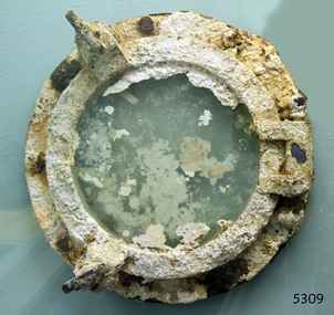 Flagstaff Hill Maritime Museum and Village
Functional object - Porthole, Alexander Stephen and Sons, 1869
This large brass porthole is from the sailing ship Newfield this would have been one of the many port holes in the vessel used for light and ventilation. The Newfield was a three-masted iron and steel barque, built in Dundee, Scotland, in 1869 by Alexander Stephen and Sons. It was owned by the Newfield Ship Company in 1890 and later that year It was registered in Liverpool to owners Brownells and Co. The Newfield left Sharpness, Scotland, on 28th May 1892 with a crew of 25 under the command of Captain George Scott and on 1st June left Liverpool. She was bound for Brisbane, Australia, with a cargo of 1850 tons of fine rock salt. On the night of 28 August 1892, the Captain mistook the Cape Otway light for that of Cape Wickham (King Island) and altered tack to the north and east putting the vessel on a collision course with the Victorian coast. At around 3:40 am the Newfield struck rocks about 100 yards from shore, and 5 feet of water filled the holds immediately. The captain gave orders to lower the boats which caused a disorganised scramble for safety among the crew. The starboard lifeboat was cleared for lowering with two seamen and two apprentices in her, but almost as soon as she touched the water she was smashed to bits against the side of the vessel, and only one of the four reached safety ashore, able seaman McLeod. The rough sea made the job of launching lifeboats very difficult. The first two lifeboats launched by the crew were smashed against the side of the ship and some men were crushed or swept away. The third lifeboat brought eight men to shore. It capsized when the crew tried to return it to the ship for further rescue The rescue was a difficult operation. The Port Campbell Rocket Crew arrived and fired four rocket lines, none of which connected with the ship. Peter Carmody, a local man, volunteered to swim about one mile offshore to the ship with a line to guide the fourth and final lifeboat safely to shore. He was assisted by James McKenzie and Gerard Irvine. Seventeen men survived the shipwreck but the captain and eight of his crew perished. The Newfield remained upright on the reef with sails set for a considerable time as the wind slowly ripped the canvas to shreds and the sea battered the hull to pieces. The Marine Board inquiry found the wreck was caused by a "one-man style of navigation" and that the Captain had not heeded the advice of his crew. For his heroic efforts, Peter Carmody was awarded the Bramley-Moore medal by the Liverpool Shipwreck and Humane Society for Saving Life at sea on January 21st 1893. The medal and a letter of congratulations were donated to Flagstaff Hill Maritime Museum by Peter Carmody's granddaughter Norma Bracken and her son Stuart Bracken on 25th May 2006. Flagstaff Hill’s collection of artefacts from the Newfield is significant for its association with the shipwreck Newfield, which is listed on the Victorian Heritage Registry. The collection is additionally significant because of the medal awarded to a local man Peter Carmody. The Newfield collection historically also represents aspects of Victoria's shipping history and its association with the shipwreck.Heavily encrusted large brass porthole, complete with glass intact object is a circular, thick glass window surrounded by a round brass frame and attached to a round brass porthole frame with 9 bolt holes. This porthole was recovered from the wreck of the NEWFIELD.Nonewarrnambool, peter carmody, newfield, port campbell, shipwreck, nineteenth century, ship, victorian shipwrecks, peterborough, peter ronald, dog screw, newfield porthole, bramley-moore medal, flagstaff hill maritime museum, shipwreck artefact, ship fitting, ship window -
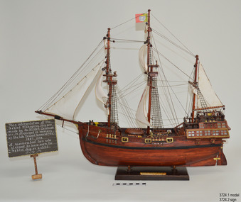 Flagstaff Hill Maritime Museum and Village
Craft - Ship Model, Portuguese Carvel, 1999
The Mahogany Ship is today regarded as a legend and refers to an ancient wreck that is purported to lie beneath the sand beside Armstrong Bay, several kilometres west of Warrnambool, Its location is currently unknown. For well over a century the mystery of this ship has fascinated Australians because the existence of such a vessel could throw a different light on the earliest phases of exploration of eastern Australia by Europeans. The story is that in January 1836 a party of whalers from Port Fairy travelled to the mouth of the Hopkins River in search of seals. Their boat overturned and one man was drowned. The three survivors were walking the 30 kilometres back to Port Fairy along the coast when, about halfway along, they discovered the wrecked ship in the dunes. It is said that Captain John Mills, who was in charge of the whaling station at Port Fairy promptly visited the wreck with several of his men, including Hugh Donnelly. Donnelly who was the originator of that version of events is now regarded as unreliable. Local history researcher Joan Fawcett believes Donnelly could not have visited the wreck in 1836 because he did not arrive in Victoria until 1841. The "mahogany" description can be traced to a letter from Port Fairy builder, architect and surveyor John Mason and published in the Melbourne Argus in 1876. He said he had seen the hull in 1846 and it "had the appearance of either cedar or mahogany." In 1884 Argus journalist `The Vagabond' wrote that the hull was built of "Spanish mahogany" and six years later Mason wrote another letter saying it might not have been mahogany but red gum or ironbark from New South Wales. He was too late with this new description as the wrecks mahogany tag was here to stay all through the hull was not visible as it had disappeared beneath the shifting sands by 1880. A more reliable account was later presented by the former editor of the Warrnambool Examiner, historian Richard Osburne, who wrote about the wreck in his book History of Warrnambool (published 1887). In it the author remembers to have noticed a wreck in the hummocks between Belfast and Warrnambool, in 1847 or 1848; he stated it was much nearer Warrnambool than Belfast, now known as Port Fairy, going on to state “in fact, it was only two or three miles from the former place, to the west of the big hummock which was supposed to fill Warrnambool Bay with drift sand washed by the Merri River before the cutting was made.” Osburne followed up with a letter to the Port Fairy Gazette on June 25, 1876, during a period of heightened interest in the wreck, although he was unsure of the provenance of the ship he went on to state in his letter. “The old wreck was, in fact, miles away from the Port Fairy beach, and only about four miles from Warrnambool. In the years 1847 and 1848. I have often seen the wreck and I regret to say I do not believe she was a foreign ship at all.”The ship model is significant for its association with the Warrnambool story of what is now referred to as the Mahogany Ship, an ancient shipwreck. The model is significant as it is an interpretation of a Portuguese caravel and possibly associated with the early history and exploration of Southern Australia. The model is a fine example of a hand crafted ship made from plans, not from a kit. Some of the materials used for the model are significant to the Gembrook community in that the timber used is a portion from a 30-meter pine tree that fell onto and destroyed the 120-year-old Gembrook church building. The model is also a dedication to Edward Kermond, who grew up in Warrnambool and claimed to have seen the shipwreck in the dunes when he was a lad in the late 19th century. (See note section of this document for further information on the creator and donation of the subject item).Ship model, an interpretation of a mahogany Portuguese carvel vessel in a glass display case with wood frame and a description plaque. Model is made from dark stained wood. The three masted vessel is fully rigged, with a Portuguese-like flag on mast. Plaque is rectangular, free standing on a pedestal. The model was handmade by Joe Hilder (Senior) in 1999 from flooring obtained from the Gembrook Uniting Church in Victoria. Inscriptions, hand written, under base of case and on plaque.Under base, black felt tip pen “Ship & Case made From / Flooring from Gembrook uniting Church, Flattened in 1999 / By Large Pine Tree.” On plaque, white paint "This interpretation of the Fabled Mahogany Ship was made by Joe Hilder, Gembrook Vic. is displayed in the memory of the late Edward Kermond (Ted) 1887-1973, a Warrnambool son who claimed to have seen the original ship as a child." flagstaff hill, warrnambool, flagstaff hill maritime museum, shipwreck coast, flagstaff hill maritime village, great ocean road, ship model, mahogany ship, mahogany ship story, portuguese caravel, joe hilder, edward kermond, ted kermond, gembrook uniting church, gembrook storm 1999, port fairy whalers, belfast whalers -
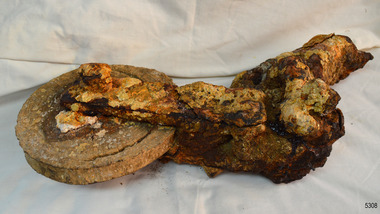 Flagstaff Hill Maritime Museum and Village
Equipment - Block, Alexander Stephen and Sons, 1869
These remains of a block, shackle and wire are from the sailing ship Newfield. This would have been one of the hundreds of blocks and shackles used in the rigging of the vessel. The Newfield was a three-masted iron and steel barque, built in Dundee, Scotland, in 1869 by Alexander Stephen and Sons. It was owned by the Newfield Ship Company in 1890 and later that year It was registered in Liverpool to owners Brownells and Co. The Newfield left Sharpness, Scotland, on 28th May 1892 with a crew of 25 under the command of Captain George Scott and on 1st June left Liverpool. She was bound for Brisbane, Australia, with a cargo of 1850 tons of fine rock salt. On the night of 28 August 1892, the Captain mistook the Cape Otway light for that of Cape Wickham (King Island) and altered tack to the north and east putting the vessel on a collision course with the Victorian coast. At around 3:40 am the Newfield struck rocks about 100 yards from shore, and 5 feet of water filled the holds immediately. The captain gave orders to lower the boats which caused a disorganised scramble for safety among the crew. The starboard lifeboat was cleared for lowering with two seamen and two apprentices in her, but almost as soon as she touched the water she was smashed to bits against the side of the vessel, and only one of the four reached safety ashore, able seaman McLeod. The rough sea made the job of launching lifeboats very difficult. The first two lifeboats launched by the crew were smashed against the side of the ship and some men were crushed or swept away. The third lifeboat brought eight men to shore. It capsized when the crew tried to return it to the ship for further rescue The rescue was a difficult operation. The Port Campbell Rocket Crew arrived and fired four rocket lines, none of which connected with the ship. Peter Carmody, a local man, volunteered to swim about one mile offshore to the ship with a line to guide the fourth and final lifeboat safely to shore. He was assisted by James McKenzie and Gerard Irvine. Seventeen men survived the shipwreck but the captain and eight of his crew perished. The Newfield remained upright on the reef with sails set for a considerable time as the wind slowly ripped the canvas to shreds and the sea battered the hull to pieces. The Marine Board inquiry found the wreck was caused by a "one-man style of navigation" and that the Captain had not heeded the advice of his crew. For his heroic efforts, Peter Carmody was awarded the Bramley-Moore medal by the Liverpool Shipwreck and Humane Society for Saving Life at sea on January 21st 1893. The medal and a letter of congratulations were donated to Flagstaff Hill Maritime Museum by Peter Carmody's granddaughter Norma Bracken and her son Stuart Bracken on 25th May 2006. Flagstaff Hill’s collection of artefacts from the Newfield is significant for its association with the shipwreck Newfield, which is listed on the Victorian Heritage Registry. The collection is additionally significant because of the medal awarded to a local man Peter Carmody. The Newfield collection historically also represents aspects of Victoria's shipping history and its association with the shipwreck.This is what remains of a block, shackle and wire from the wreck of the sailing ship “Newfield”. The object is heavily encrusted. The exterior (cheeks) of the block is missing. The disc of the block has a channel part way around its face, about 2 cm from the edge. Two long, narrow plates are joined onto the centre of the disc’s face with a bolt through the centre. The other ends of the two plates join onto the elbow of the shackle. The elbow of the shackle is also joined onto a rod. At the other end of the rod can be seen the ends of thick wire strands.block, 1893, flagstaff hill, flagstaff hill maritime museum, peter carmody, newfield, 1892, port campbell, shipwreck, ship, victorian shipwrecks, barque, ship wreck, peterborough, sailing ship, 29 august 1892, block and shackle, curdies river, bramley-moore medal -
 Federation University Historical Collection
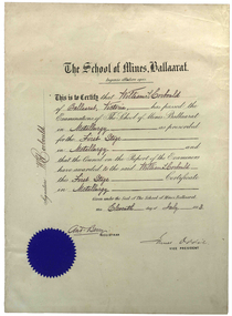
Certificate, Ballarat School of Mines, William Corbould's Ballarat School of Mines Metallurgy Certificate, 11/07/1883
William Corbould was the son of a Ballarat tailor. He attended Ballarat College, and obtained certificates in assaying and metallurgy at the Ballarat School of Mines (SMB) in 1883, studying under the revered Professor Mica Smith. Corbould was not a born student and remembered his first experience at SMB: 'From the Registrar's Office I was led to be introduced to the Professor of Chemistry, one Mica Smith. The initial encounter gave me little encouragement - his large laboratory was filled with hundreds of bottles bearing strange labels with queer symbols on them. My heart sank. At the first opportunity I grabbed my hat and made for the door, but the good professor called me back. I pointed out that I was never any good at school ... so it was no use pretending to be clever enough to understand all those weird symbols! The Professor told me not to worry about that and took me to one of the benches where he found a blowpipe and a charcoal block. Mixing together two powders from bottles on the shelf he transferred a sample to the charcoal and directed the bunsen flame onto it. Soon it began to melt and a white bead appeared in front of my eyes. He then took a test tube and added a little colourless liquid from each of two bottles. A beautiful dark blue colour appeared. My interest was won.' During Corbould's mining career he travelled to Europe twice, and visited most of Australia's main mining fields. Corbould started his career as an assayer at Pinnacle Silver Mine, Silverton, and was then a self-employed assayer at Broken Hill. Corbould became an assayer for the infant BHP mine, and later worked in Kalgoorlie and Coolgardie, including managing Hannan's Reward, the oldest gold mine on the Kalgoorlie gold field. He spent 13 years at the Mount Elliott copper fields as general manager. In 1923, at the age of 57, Corbould went to Mount Isa and reported on options, experimented with new metallurgical processes and floated a company. John Carden of CRA said: 'Corbould was the man who brought Urquhart to Mount Isa. He was the man who made it all possible. He is tremendously important in the Mount Isa story, because he was the first technical man, the first professional man on the scene. He was responsible as I said, for bringing finance to the place, but I think even more importantly he was the first man to recognise the need to put all the little claims in the Mount Isa discovery together. I think perhaps his major contribution to Mount Isa was this amalgamation on the various claims. He recognised that the ore bodies at Mount Isa were not as rich as Broken Hill and they would never have survived had it been fragmented, so he was terribly important.' After completing major financial negotiations for Mt Isa Mine from London in 1927 Corbould remained in Europe where he remained until his death. Corbould was awarded the Legion of Honour of the American Institute of Mining and Metallurigical Engineers for fifty years service. Corbould died at Monaco in 1949 at the age of 82. (http://guerin.ballarat.edu.au/curator/honour-roll/honourroll_Corbould,William.shtml)A white paper certificate with black printed and handwritten text, and a blue Ballarat School of Mines seal. The certificate is signed by Andrew Berry (Registrar) and James Oddie (Vice-President).Signed on the left 'W.H. Corbould'mining, ballarat school of mines, mining alumni, metallurgy, james oddie, andrew berry, william corbould, corbould, berry, oddie -
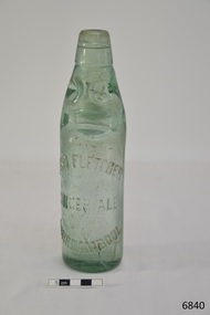 Flagstaff Hill Maritime Museum and Village
Container - Bottle, c. 1905
This bottle once contained John Fletcher’s ginger cordial. It was found in August 2014 in the sand dunes at Levy's Point, near McKinnon's quarry, Warrnambool. ABOUT JOHN FLETCHER of WARRNAMBOOL John Fletcher Cordial (or Beverage) Co . Warrnambool, supplied cordial and aerated drinks to the Western district of Victoria. John Fletcher was named as a cordial manufacturer in the Warrnambool Standard of June 13th 1895, when he attended a Publican’s Association meeting. Mr John Fletcher, aerated water and cordial manufacturer of Koroit Street Warrnambool, had a summary of his factory printed in a short article in the Advocate, Melbourne, in February 1901. The article said “one of the most complete plants outside the metropolis … spacious … well appointed …old-established business … noted for the excellence of the quality … a trial [of the beverage] is solicited.” John Fletcher and Harold Caffin, trading as J.S. Rowley & co cordial manufacturers in 1903; were prosecuted in September 1903 when the Board of Health found an analysed sample of Raspberry Vinegar to contain coal tar colouring, which could be injurious to health, particularly to the kidneys. The factory was still in operation in December 1924, when sadly, Mr S. Fletcher, who was carrying bottles of aerated water at Mr John Fletcher’s cordial factory, sustained an eye injury when one of the bottles burst. Later the eye had to be removed at the Warrnambool Base Hospital. ABOUT CODD BOTTLES During the mid-to-late 1800s there were many inventions to keep the fizz in carbonated drinks such as ginger ale, soda water and fruit drinks. Hiram Codd, an English engineer invented a successful process that he patented as “Codd’s patented globe stopper bottle” in 1872. The Codd-neck bottle (commonly called Codd or marble bottle) is manufactured in two parts. The body of the bottle is cast in two sections. At the time of joining the sections a glass marble and rubber seal are inserted into the neck section. The lip is then applied to the top of the bottle. The Codd bottle is filled upside down as the pressure of the gas from the carbonated liquid holds the marble up and out of the way. When the bottle stands upright the gas pushes the marble up against the washer, creating a firm seal to keep the fizz inside. The bottle is opened by pushing the marble down firmly to allow some of the gas to escape. The marble drops down and is caught in a depression formed in the neck. When the bottle is tilted to pour or drink the liquid the marble rests in a dimple. Some have said that the bottle as a character, the shape having a face with its mouth keeping the marble out of the drink and eyes that catch the marble so that it doesn’t roll into the mouth of the drinker. The Codd bottle was expensive to produce and children loved to destroy the marbles to play with the marbles inside. Many shops and factories added a deposit to the cost of buying the drink to encourage children to return the bottles rather than break it for the marble. Codd bottles are still being produced in India and Japan for soft drinks. A Codd bottle with the same markings as this one is valued on today’s Australian auction sites from $35 - $75 AUD. Bottle, aqua/green glass, with glass marble inside. John Fletcher's Ginger Ale, Warrnambool. Container is often called a "Codd neck bottle", “marble bottle” or “Codd’s patent bottle”. Bottle made by Dobson. Inscription on bottle and base. c. 1905Marks moulded into glass; "JOHN FLETCHER / GINGER ALE / WARRNAMBOOL" and “DOBSON” and on base “G”. flagstaff hill, warrnambool, shipwrecked coast, flagstaff hill maritime museum, maritime museum, shipwreck coast, flagstaff hill maritime village, great ocean road, codd bottle, codd neck bottle, marble bottle, ginger beer bottle, john fletcher soft drinks, warrnambool soft drinks and cordials, john fletcher cordial (or beverage) co ., codd neck bottle, glass stopper bottle, hiram codd, antique bottle, harold caffin, john fletcher -
 Eltham District Historical Society Inc
Photograph, Slab hut, Warrandyte, Warrandyte Mystery Tour, 29 May 1994, 29/05/1994
[article by Bettina Woodburn in EDHS Newsletter No. 97, July 1994:] THE WARRANDYTE MYSTERY TOUR MAY 29TH 1994 - Members of the Eltham Historical Society met at the Old Post Office, now converted into the Warrandyte Historical Museum, for a picnic lunch on the sunny back verandah overlooking the shimmering Yarra River. Interesting photographs and artefacts filled various rooms outlining the history of this area, and told tales of Aboriginal and more recent neighbours of the Eltham Shire. The weather was calm, cloudy mostly with only occasional sunny patches, but it wasn't cold, although the autumnal leaf colours had changed to wintry brown. "All Aboard" and we set off in the Warrandyte Community Bus (with the School Bus sign displayed at the rear) to learn about local places of "Pride and Joy” from Bruce our guide and Tom the driver. Almost directly opposite we entered Whipstick Gully to explore the first of the district's hidden treasures - the Victory, one of the largest of the six or so major mines, past the old quarry now used for abseiling practice. By torchlight we entered the rocky hillside and saw the seams of quartz the miners had followed in their search for gold. Stamping batteries, and there was one in this gully, converted discarded rock into 'road metal'. Warrandyte is proud to be the first declared Goldfield in 1851, and one of the longest surviving, into the 1920s. A pleasant drive across the Bridge and along Bradley's Lane to Norman's Reserve brought us to see another Tunnel at Pound Bend through which the Yarra was diverted to allow about three miles of river-bed to be used for prospecting for alluvial gold. Still on this side of the river we visited the Old Slab Hut in Castles Road. This remnant of miners' housing is preserved because it had been incorporated into a weatherboard house, and saved from the bulldozers - a last minute reprieve, for preservation, by the National Trust. Devastating bush fires have destroyed other old cottages built of wattle and daub, with bark roofs and stone fire-places. The Cairn commemorating the disclosure of Gold Discovery at Warrandyte on June 30th 1851 beside Anderson's Creek Road was our next point of historical interest. We drove on to South Warrandyte and circled back to above the ford on Anderson's Creek to the entrance of the 4th Hill Mine. Again we crept along with our torches, careful of the low roof-rock, and side shafts. At a junction in a large cavity we were able to stand, look up a long air-vent which some 'cavers' climb down, and marvel at, and experience an aspect of a miner's life. Outside we heard the same bird songs, the trills and bell-pealing, saw the same straggly eucalypts, and a silver leafed wattle in flower, native grasses and ferns, and the neat present day houses, often of Warrandyte stone, perhaps veneered only. The day ended pleasantly, seeing more of the Yarra from Everard Drive, and the water rushing out of the Tunnel at Pound Bend, before returning to afternoon tea or coffee at the Museum. A great day for all concerned - many thanks to the Organisers.Colour photographslab hut, warrandyte, "warrandyte miner's cottage" -
 Eltham District Historical Society Inc
Photograph, Pound Bend tunnel, Warrandyte, Warrandyte Mystery Tour, 29 May 1994, 29/05/1994
[article by Bettina Woodburn in EDHS Newsletter No. 97, July 1994:] THE WARRANDYTE MYSTERY TOUR MAY 29TH 1994 - Members of the Eltham Historical Society met at the Old Post Office, now converted into the Warrandyte Historical Museum, for a picnic lunch on the sunny back verandah overlooking the shimmering Yarra River. Interesting photographs and artefacts filled various rooms outlining the history of this area, and told tales of Aboriginal and more recent neighbours of the Eltham Shire. The weather was calm, cloudy mostly with only occasional sunny patches, but it wasn't cold, although the autumnal leaf colours had changed to wintry brown. "All Aboard" and we set off in the Warrandyte Community Bus (with the School Bus sign displayed at the rear) to learn about local places of "Pride and Joy” from Bruce our guide and Tom the driver. Almost directly opposite we entered Whipstick Gully to explore the first of the district's hidden treasures - the Victory, one of the largest of the six or so major mines, past the old quarry now used for abseiling practice. By torchlight we entered the rocky hillside and saw the seams of quartz the miners had followed in their search for gold. Stamping batteries, and there was one in this gully, converted discarded rock into 'road metal'. Warrandyte is proud to be the first declared Goldfield in 1851, and one of the longest surviving, into the 1920s. A pleasant drive across the Bridge and along Bradley's Lane to Norman's Reserve brought us to see another Tunnel at Pound Bend through which the Yarra was diverted to allow about three miles of river-bed to be used for prospecting for alluvial gold. Still on this side of the river we visited the Old Slab Hut in Castles Road. This remnant of miners' housing is preserved because it had been incorporated into a weatherboard house, and saved from the bulldozers - a last minute reprieve, for preservation, by the National Trust. Devastating bush fires have destroyed other old cottages built of wattle and daub, with bark roofs and stone fire-places. The Cairn commemorating the disclosure of Gold Discovery at Warrandyte on June 30th 1851 beside Anderson's Creek Road was our next point of historical interest. We drove on to South Warrandyte and circled back to above the ford on Anderson's Creek to the entrance of the 4th Hill Mine. Again we crept along with our torches, careful of the low roof-rock, and side shafts. At a junction in a large cavity we were able to stand, look up a long air-vent which some 'cavers' climb down, and marvel at, and experience an aspect of a miner's life. Outside we heard the same bird songs, the trills and bell-pealing, saw the same straggly eucalypts, and a silver leafed wattle in flower, native grasses and ferns, and the neat present day houses, often of Warrandyte stone, perhaps veneered only. The day ended pleasantly, seeing more of the Yarra from Everard Drive, and the water rushing out of the Tunnel at Pound Bend, before returning to afternoon tea or coffee at the Museum. A great day for all concerned - many thanks to the Organisers.Two colour photographswarrandyte, activities, pound bend -
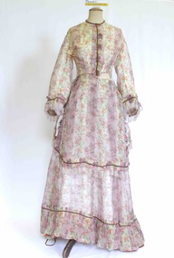 Brighton Historical Society
Clothing - Dress, Day dress, circa 1870
The donor and family of this gown were long-term Brighton residents, and the gowns were held by them as family heirlooms prior to donation to Brighton Historical Society. Originally owned by Elizabeth Emma Adams and Cecilia Elizabeth Adams, it is believed that the dress was brought to Australia by either a half brother, James Smith Adams, or a younger sister, Sophia Charlotte Louisa Adams (later known as Mother Rose Columba Adams). Elizabeth and Cecilia were the daughters of James Smith Adams (a squire, 1780-1860) and Elizabeth Emma McTaggart (1793-1843) of Tower House, Woodchester in Gloucester, a property which Elizabeth later inherited. Originally a monastery, Tower House had been converted into a stately home after the Reformation. According to information originally provided by the donor, both this dress and the dress T0004.3 were made for Elizabeth and Cecilia, to be worn at the young Queen Victoria’s first 'drawing room ball' following the end of court mourning in 1838 for her uncle William IV who died in 1837. In 1838 Cecilia would have been twelve years old and Elizabeth would have been ten years old. It is possible that the dress T0004.3 was worn by one of the girls to this event as it is of appropriate dimensions for a child of that age, although its design is very formal and adult. However, it is unlikely that either of the girls wore this dress at the ball due to the size and styling of the dress. It is likely that the dress belonged to one of the girls, but was worn at a later date. Elizabeth was born on 30 June 1828 at Tower House and died on 1 May 1909. She created a scandal when she eloped with her first husband, Thomas Charles Gardiner at the age of 18. The validity of the marriage was later formally investigate and, while it was confirmed as valid, a second church wedding was subsequently held. Thomas died in 1878. Elizabeth subsequently remarried Reverend R. E. Blackwell, but was widowed again by 1889. Cecilia was born on 17 December 1826 and died in 1902 a spinster recluse in England. At the inquest into Cecelia's death in 1904 it was revealed that she had clearly come from a family of means as her home was filled to the brim with highly valuable goods, many in boxes. She was buried in the family vault at Woodchester. Elizabeth and Cecilia's sister Sophia converted to Roman Catholicism in 1851 and became a nun, taking the religious name 'Rose Columba'. In 1883 Mother Rose Columba led a group of eight to Australia, answering a call for Dominican sisters to nurse the sick in Adelaide. Upon arrival, she founded St. Dominic's Priory and the Church of Perpetual Adoration in North Adelaide, using her inheritance to build the chapel. Elizabeth's second son, George Henry Somerset, who inherited the Adams family estate dropped the 'i' in Gardiner and added the maiden name of his grandmother. Therefore, the family name has now become Gardner McTaggart. These Adams family entries have been updated with information provided by Dr Herbert Gardner McTaggart, great-grandson of George Henry Somerset in April 2016. Mr McTaggart contacted the society after finding our entries online.A hand sewn white purple, pink, green, blue and yellow floral silk chiffon dress from circa 1870. The dress consists of two pieces worn together as a dress. This dress has received a great deal of mending and alteration and so it is difficult to be sure of what constitutes its original state. The following description is of its current state. The bodice has a high neck with a simple shallow band collar, an olive braid and a press stud closure. The bodice fastens down the centre front with ten hook and eyes closures and two sets of ribbon ties . The bodice has three darts providing shaping into the waistline. The bodice finishes at the waist and gently tapers towards the front creating a 'V' line. Down the centre front from the neck to the waist concealing the bodice opening is a pressed pleated ruffle of the dress fabric and a line of olive braid. The dress features pagoda sleeves finished at the hem with pressed pleated ruffle of the dress fabric, a line of olive braid and a silk fringe of 4 cm pale pink and white. The skirt part of the bodice section attaches to the front of the dress with two hooks and eyes on the left hand side of the waist. The fabric drops down to approximately the knees at the front, curving up and splitting on either side over the hip. The edge of this piece is also trimmed with a pressed pleated ruffle of the dress fabric and a line of olive braid. Just below the hip on either side is a large bow of pink, cream, purple and green taffeta. The bodice at the back is shaped with four panels into the waistline. Where it joins the bodice skirt the skirt is pleated, creating fullness. The skirt of the dress ensemble secures at the waist on the left hand side. At the front it has two pleats (that may have been repositioned during repair), and is fully gathered at the back. At the front the dress falls to the floor whilst at the back it is longer to accommodate the bustle and possibly a small train.cecilia elizabeth adams, elizabeth emma adams, 1870s fashion, tower house, woodchester, james smith adams, elizabeth emma mctaggart, mary rose columba adams, sophia charlotte louisa adams -
 Eltham District Historical Society Inc
Photograph - Postcard, The Great Tokyo Earthquake on September 1st, 1923: Fire in the middle of rain, 1923
The Great Kantō Earthquake of 1 September 1923 devastated the major cities of Tokyo and Yokohama, as well as five other surrounding prefectures and was one of the world’s worst natural disasters of the early twentieth century. In terms of loss of life and material damage, with an estimated 140,000 deaths and countless homeless, it is still Japan’s worst national disaster. Nearly 90% of the newspaper printers were destroyed in the earthquake. These postcards were not produced for aesthetics but as a major tool for the spread of information. Seeing how newspaper companies were left with their offices in shambles, postcard publishers tried to fill the gap hence some were in three languages. A very small number of publishing companies were fortunate enough to survive, one of them being Mitsumura Printing, which took advantage of its remaining resources to churn out postcards. When the Ōsaka Mainichi Shinbunsha published its bilingual three-volume photographic pictorial of the Great Kantō Earthquake just two weeks after the event, the calamity had already been captured in thousands of images that circulated on a national and international media highway. Commercial photographers and photojournalists produced the most abundant and immediate images of the quake, which were transmitted in newspapers, special-issue newspaper pictorials, commemorative photography collections, illustrated survivors’ accounts, and sets of commemorative postcards. These photographic images functioned as both news and souvenirs, rendering their consumers/viewers, inside and outside the devastated locale, into both witnesses and voyeurs. Images in the news media and those issued by respected publishing houses carried the visual authority of supposed facticity. As such they both produced and became the historical record of the event. Since the vast majority of 1923 disaster postcards that survive have no writing on them, they were likely treated more as collectibles than as a form of postal communication. Many were put into albums, creating new ways to combine images and create visual cultures of disaster for home viewing. Accordion-style albums allowed for personalized, serial organization of images that produced unique, imagistic narratives of the event. The album pages were also two-sided and could be stretched out to view a series of images on recto and verso. References: Imaging Disaster: Tokyo and the Visual Culture of Japan’s Great Earthquake of 1923 震災をイメージ化する 東京と1923年関東大震災のヴィジュアルカルチャー - The Asia. (2024, March 31). Retrieved from https://apjjf.org/2015/13/6/gennifer-weisenfeld/4270 The Great Kanto Earthquake: Postcards of Tragedy. (2024, March 31). Retrieved from https://www.tokyoweekender.com/art_and_culture/japanese-culture/the-great-kanto-earthquake-postcards/ See also: Postcards from Hell – Glimpses of the Great Kantō Earthquake; M. William STEELE (International Christian University, Japan) 14th Conference of the European Association of Japanese Studies: Visual Culture and Postcard Research Papers – East Asia Image Collection Blog. (2024, March 31). Retrieved from https://sites.lafayette.edu/eastasia/2014/09/01/14th-conference-of-the-european-association-of-japanese-studies-visual-culture-and-postcard-research-papers/] And https://icu.repo.nii.ac.jp/record/4503/files/ACS44_01Steele.pdfThis item, a souvenir from Japan from between the wars (circa 1923) was brought home to Research, Victoria by Bill Teagle who was serving in the Royal Australian Navy (1919-1945). Bill Teagle's sister Violet Amelda Teagle had married Theodore (Curly) Feldbauer in 1933. Bill's brother-in-law Curly was taken as a Prisoner of War by the Japanese and died at Sandakan in March 1945. The family did not learn of Curly’s death till months later and Bill's sister, Violet, herself could never forgive the Japanese for what happened to Curly. Curly is remembered on the Eltham Roll of Honour Board and his son, Albert Feldbauer (Bill’s nephew and youngest child of the children of the soldier fathers attending a school in the district), was given the honour of turning the first sod for the Eltham War Memorial Infant Welfare Centre Building. Despite this, the family maintained this cherished souvenir from a time of previous foreign friendship with Japan. The item was possibly given by Bill Teagle to his sister Margaret Rose (formerly Ingram) who later married Richard Edward (Eddie) Fielding in early 1948. (Eddie had been engaged to someone else before he went to war, but his fiancée broke it off before his return to Australia.) It was cared for by the Teagle/Fielding family for approximately one hundred years. It is of particular significance given the family's connection to the Eltham War Memorial and the significance of that memorial to the local community and represents that despite the horrors of war, former friends then foes can become friends again.tom fielding collection, japanese postcard, postcard, 1923, great kanto earthquake, japan, tokyo, yokohama -
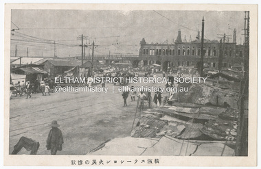 Eltham District Historical Society Inc
Photograph - Postcard, The Great Tokyo Earthquake on September 1st, 1923: The situation is miserable, 1923
The Great Kantō Earthquake of 1 September 1923 devastated the major cities of Tokyo and Yokohama, as well as five other surrounding prefectures and was one of the world’s worst natural disasters of the early twentieth century. In terms of loss of life and material damage, with an estimated 140,000 deaths and countless homeless, it is still Japan’s worst national disaster. Nearly 90% of the newspaper printers were destroyed in the earthquake. These postcards were not produced for aesthetics but as a major tool for the spread of information. Seeing how newspaper companies were left with their offices in shambles, postcard publishers tried to fill the gap hence some were in three languages. A very small number of publishing companies were fortunate enough to survive, one of them being Mitsumura Printing, which took advantage of its remaining resources to churn out postcards. When the Ōsaka Mainichi Shinbunsha published its bilingual three-volume photographic pictorial of the Great Kantō Earthquake just two weeks after the event, the calamity had already been captured in thousands of images that circulated on a national and international media highway. Commercial photographers and photojournalists produced the most abundant and immediate images of the quake, which were transmitted in newspapers, special-issue newspaper pictorials, commemorative photography collections, illustrated survivors’ accounts, and sets of commemorative postcards. These photographic images functioned as both news and souvenirs, rendering their consumers/viewers, inside and outside the devastated locale, into both witnesses and voyeurs. Images in the news media and those issued by respected publishing houses carried the visual authority of supposed facticity. As such they both produced and became the historical record of the event. Since the vast majority of 1923 disaster postcards that survive have no writing on them, they were likely treated more as collectibles than as a form of postal communication. Many were put into albums, creating new ways to combine images and create visual cultures of disaster for home viewing. Accordion-style albums allowed for personalized, serial organization of images that produced unique, imagistic narratives of the event. The album pages were also two-sided and could be stretched out to view a series of images on recto and verso. References: Imaging Disaster: Tokyo and the Visual Culture of Japan’s Great Earthquake of 1923 震災をイメージ化する 東京と1923年関東大震災のヴィジュアルカルチャー - The Asia. (2024, March 31). Retrieved from https://apjjf.org/2015/13/6/gennifer-weisenfeld/4270 The Great Kanto Earthquake: Postcards of Tragedy. (2024, March 31). Retrieved from https://www.tokyoweekender.com/art_and_culture/japanese-culture/the-great-kanto-earthquake-postcards/ See also: Postcards from Hell – Glimpses of the Great Kantō Earthquake; M. William STEELE (International Christian University, Japan) 14th Conference of the European Association of Japanese Studies: Visual Culture and Postcard Research Papers – East Asia Image Collection Blog. (2024, March 31). Retrieved from https://sites.lafayette.edu/eastasia/2014/09/01/14th-conference-of-the-european-association-of-japanese-studies-visual-culture-and-postcard-research-papers/] And https://icu.repo.nii.ac.jp/record/4503/files/ACS44_01Steele.pdfThis item, a souvenir from Japan from between the wars (circa 1923) was brought home to Research, Victoria by Bill Teagle who was serving in the Royal Australian Navy (1919-1945). Bill Teagle's sister Violet Amelda Teagle had married Theodore (Curly) Feldbauer in 1933. Bill's brother-in-law Curly was taken as a Prisoner of War by the Japanese and died at Sandakan in March 1945. The family did not learn of Curly’s death till months later and Bill's sister, Violet, herself could never forgive the Japanese for what happened to Curly. Curly is remembered on the Eltham Roll of Honour Board and his son, Albert Feldbauer (Bill’s nephew and youngest child of the children of the soldier fathers attending a school in the district), was given the honour of turning the first sod for the Eltham War Memorial Infant Welfare Centre Building. Despite this, the family maintained this cherished souvenir from a time of previous foreign friendship with Japan. The item was possibly given by Bill Teagle to his sister Margaret Rose (formerly Ingram) who later married Richard Edward (Eddie) Fielding in early 1948. (Eddie had been engaged to someone else before he went to war, but his fiancée broke it off before his return to Australia.) It was cared for by the Teagle/Fielding family for approximately one hundred years. It is of particular significance given the family's connection to the Eltham War Memorial and the significance of that memorial to the local community and represents that despite the horrors of war, former friends then foes can become friends again.tom fielding collection, japanese postcard, postcard, 1923, great kanto earthquake, japan, tokyo, yokohama -
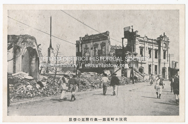 Eltham District Historical Society Inc
Photograph - Postcard, The Great Tokyo Earthquake on September 1st, 1923: Bank in Chidoricho Hungama, 1923
The Great Kantō Earthquake of 1 September 1923 devastated the major cities of Tokyo and Yokohama, as well as five other surrounding prefectures and was one of the world’s worst natural disasters of the early twentieth century. In terms of loss of life and material damage, with an estimated 140,000 deaths and countless homeless, it is still Japan’s worst national disaster. Nearly 90% of the newspaper printers were destroyed in the earthquake. These postcards were not produced for aesthetics but as a major tool for the spread of information. Seeing how newspaper companies were left with their offices in shambles, postcard publishers tried to fill the gap hence some were in three languages. A very small number of publishing companies were fortunate enough to survive, one of them being Mitsumura Printing, which took advantage of its remaining resources to churn out postcards. When the Ōsaka Mainichi Shinbunsha published its bilingual three-volume photographic pictorial of the Great Kantō Earthquake just two weeks after the event, the calamity had already been captured in thousands of images that circulated on a national and international media highway. Commercial photographers and photojournalists produced the most abundant and immediate images of the quake, which were transmitted in newspapers, special-issue newspaper pictorials, commemorative photography collections, illustrated survivors’ accounts, and sets of commemorative postcards. These photographic images functioned as both news and souvenirs, rendering their consumers/viewers, inside and outside the devastated locale, into both witnesses and voyeurs. Images in the news media and those issued by respected publishing houses carried the visual authority of supposed facticity. As such they both produced and became the historical record of the event. Since the vast majority of 1923 disaster postcards that survive have no writing on them, they were likely treated more as collectibles than as a form of postal communication. Many were put into albums, creating new ways to combine images and create visual cultures of disaster for home viewing. Accordion-style albums allowed for personalized, serial organization of images that produced unique, imagistic narratives of the event. The album pages were also two-sided and could be stretched out to view a series of images on recto and verso. References: Imaging Disaster: Tokyo and the Visual Culture of Japan’s Great Earthquake of 1923 震災をイメージ化する 東京と1923年関東大震災のヴィジュアルカルチャー - The Asia. (2024, March 31). Retrieved from https://apjjf.org/2015/13/6/gennifer-weisenfeld/4270 The Great Kanto Earthquake: Postcards of Tragedy. (2024, March 31). Retrieved from https://www.tokyoweekender.com/art_and_culture/japanese-culture/the-great-kanto-earthquake-postcards/ See also: Postcards from Hell – Glimpses of the Great Kantō Earthquake; M. William STEELE (International Christian University, Japan) 14th Conference of the European Association of Japanese Studies: Visual Culture and Postcard Research Papers – East Asia Image Collection Blog. (2024, March 31). Retrieved from https://sites.lafayette.edu/eastasia/2014/09/01/14th-conference-of-the-european-association-of-japanese-studies-visual-culture-and-postcard-research-papers/] And https://icu.repo.nii.ac.jp/record/4503/files/ACS44_01Steele.pdfThis item, a souvenir from Japan from between the wars (circa 1923) was brought home to Research, Victoria by Bill Teagle who was serving in the Royal Australian Navy (1919-1945). Bill Teagle's sister Violet Amelda Teagle had married Theodore (Curly) Feldbauer in 1933. Bill's brother-in-law Curly was taken as a Prisoner of War by the Japanese and died at Sandakan in March 1945. The family did not learn of Curly’s death till months later and Bill's sister, Violet, herself could never forgive the Japanese for what happened to Curly. Curly is remembered on the Eltham Roll of Honour Board and his son, Albert Feldbauer (Bill’s nephew and youngest child of the children of the soldier fathers attending a school in the district), was given the honour of turning the first sod for the Eltham War Memorial Infant Welfare Centre Building. Despite this, the family maintained this cherished souvenir from a time of previous foreign friendship with Japan. The item was possibly given by Bill Teagle to his sister Margaret Rose (formerly Ingram) who later married Richard Edward (Eddie) Fielding in early 1948. (Eddie had been engaged to someone else before he went to war, but his fiancée broke it off before his return to Australia.) It was cared for by the Teagle/Fielding family for approximately one hundred years. It is of particular significance given the family's connection to the Eltham War Memorial and the significance of that memorial to the local community and represents that despite the horrors of war, former friends then foes can become friends again.tom fielding collection, japanese postcard, postcard, 1923, great kanto earthquake, japan, tokyo, yokohama