Showing 2671 items matching "hut"
-
 Melbourne Tram Museum
Photograph - Set of two Black & White Photograph/s, 1950's? to 1960's
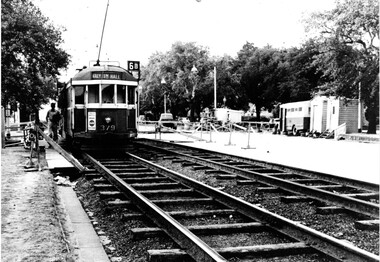
Black and white photograph of trams on temporary track in St Kilda Road, Melbourne, late 1950's or early 1960's. Shows timber sleepered track, temporary huts, a transport bus, air compressor and temporary barriers and kerosene lamps. .1 - W2 379 outbound on temporary track, destination of Malv Tn Hall (Malvern Town Hall) route 6B. .2 - W2 262, followed by 775 and two other trams. W2 has the destination of East Malvern Darling Road, Route 4D. Printed on Fujichrome paper. Not known who took the photograph or when it was printed.Stamped in black ink on back "TMSV Sales"trams, tramways, st kilda rd, temporary track, reconstruction, malvern town hall, darling rd, tram 379, tram 262, tram 775 -
 Alfred Hospital Nurses League - Nursing History Collection
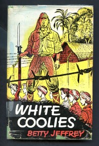
Book - Illustrated Book, Betty Jeffrey 1908-2000 et al, White Coolies, 1954
In 1942 a group of sixty-five Australian Army nursing sisters was evacuated from Malaya aboard the Vyner Brooke, a few days before the fall of Singapore. Two days later their ship was bombed and sunk by the Japanese. Of the fifty-three survivors who scrambled ashore, twenty-one were murdered and the remaining thirty-two were taken prisoner. The book is the engrossing record kept by one of the sisters, Betty Jeffrey, during the three grueling years of imprisonment that followed. It is an amazing story of survival and deprivation in the harshest of conditions.Illustrated book with dustjacket. Book has a light green cover, with an image of a compass embossed in gold. on the front. The tile author's surname and publisher's name are embossed in gold on the spine. Dust jacket has multicoloured illustration by J.P.L Kickhefer on front and spine: group of women, some with head scarves walking behind a ?prison guard, barbed wire topped fence in front of and behind group. In the background is a hut and tropical plants. Title (white print) and authors name (red print) appear on a black background at base of front of dustjacket. Title, author's and publisher's names are printed in black on spinenon-fictionIn 1942 a group of sixty-five Australian Army nursing sisters was evacuated from Malaya aboard the Vyner Brooke, a few days before the fall of Singapore. Two days later their ship was bombed and sunk by the Japanese. Of the fifty-three survivors who scrambled ashore, twenty-one were murdered and the remaining thirty-two were taken prisoner. The book is the engrossing record kept by one of the sisters, Betty Jeffrey, during the three grueling years of imprisonment that followed. It is an amazing story of survival and deprivation in the harshest of conditions.world war 1939-1945 prisoners of war, betty jeffrey -
 Bendigo Historical Society Inc.
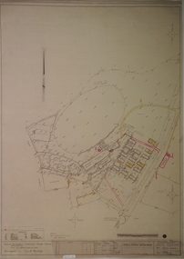
Plan - SANDHURST BOYS CENTRE COLLECTION: PART DETAIL SURVEY
Prepared by the Public Works Department for the Government of Victoria. Client is the Mental Health Department, Municipality is City of Bendigo. Site plan of area bounded by O'Dwyer St and Finn St, North Bendigo. Handwritten note on back - Update of whole centre 10/4/91. Details include: oval, tennis court, grandstand, area is bounded by an un-named watercourse. Also indicated are 14 nissen huts, 2 toilet blocks, 3 weatherboard buildings, 1 galvanised iron building,2 galvanised iron sheds (one new), residence, garage, fowl shed, and a carpark. bendigo, institutions, sandhurst boys centre, sandhurst boys centre site plan; -
 Orbost & District Historical Society
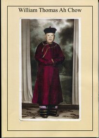
Booklet - Booklet, softcover, William Thomas Ah Chow, March 2019
This family history book was published as a family record of the Ah Chow family. A limited number of copies were printed. Thomas William (Bill) Ah Chow was a Chinese-Australian soldier, farmer, fire lookout and legendary bushman of East Gippsland in Victoria. Many Chinese came to the Victorian gold rush in the 1850s to seek their fortune at the Omeo and Cassilis diggings. Many of the immigrants later settled and integrated into their local communities working as farm labourers, tending market gardens, making furniture, running grocery stores and cafes or practising Chinese medicine. Thomas William "Bill" Ah Chow of Bruthen, Victoria attempted to enlist early in the War but was rejected for being "not substantially of European origin". Undeterred, he reapplied and was accepted in June 1917. During his service with the 5th Battalion, he was wounded at least three times. After the War, Bill returned to Bruthen where he drove sheep, worked cattle and eventually assisted in the building of roads through the area. He became a Forestry Commission fire-spotter and built a hut called 'Moscow Villa' in 1942. He lived in the hut during the summer months and in winter, returned to his family in Ensay. Whenever there was fire danger, he rode his horse up to the fire tower on Mt Nugong and acted as look-out. Bill worked for the Forestry Commission for more than twenty years and came out of retirement to continue his duties when no suitable replacement could be found. Bill died in 1967 and is buried in Omeo. Moscow Villa still stands and is a popular camping site This is a useful reference item. As a family history it is detailed and contains useful copies of personal documents. Bill Ah Chow, along with the Ah Chow family were well known in Orbost and East Gippsland. This booklet is a testament to his life. A soft covered 97pp book with a cream cover. On the front is a coloured photograph of a Chinese man in traditional robe and hat. On the back cover is Moscow Villa. It contains information, copies of 1949 photographs, documents, hand -written letters and a will. There is an envelope attached to the inside cover containing a CD, photos and family tree.ah-chow-william-thomas family-history-ah-chow -
 The Beechworth Burke Museum
Photograph, 1865
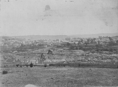
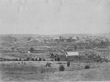
This image was taken in 1865 overlooking the diggings at Spring Creek, Beechworth. Gold was discovered in this area in 1852 and within eleven months of this discovery, over 8000 hopeful prospectors had descended on the region, transforming the seemingly undisturbed land into what a visiting journalist in 1880s referred to as; "A Titan's Field". Huge mounds of earth were churned by hundreds of miners in search for gold, almost every available resource the land had to offer was used for something; even the bark off the gums were stripped to line huts and shafts. By 1857 more than 20,000 people lived in Beechworth, and with this influx the town prospered with the building of numerous churches, banks, schools, shops and hotels along with a prison and hospital.Black and white rectangular photograph. Image is printed on matte photographic paper and is mounted on cardboard. Obverse: NO INSCRIPTION Reverse: 7771 / BEECHWORTH / FROM SPRING CREEK / 1865 spring creek, diggings, beechworth, 1865 -
 The Beechworth Burke Museum
Photograph, 1865
This image was taken of the diggings at Spring Creek. In February 1852 gold was discovered at Spring Creek, Beechworth. Within eleven months of this discovery, over 8000 hopeful prospectors had descended on the region, transforming the seemingly undisturbed land into what a visiting journalist in 1880s referred to as; "A Titan's Field". Huge mounds of earth were churned by hundreds of miners in search for gold, almost every available resource the land had to offer was used for something; even the bark off the gums were stripped to line huts and shafts. By 1857 more than 20,000 people lived in Beechworth, and with this influx the town prospered with the building of numerous churches, banks, schools, shops and hotels along with a prison and hospital.Black and white rectangular photograph. Image is printed on matte photographic paper and is mounted on cardboard. Obverse: NO INSCRIPTION Reverse: BMM6926 / BEECHWORTH FROM SPRING CREEK 1865 spring creek, beechworth, burke museum, 1865, gold rush -
 Bendigo Military Museum
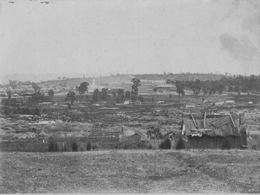
Honour Board - EAGLEHAWK RSL HONOUR BOARD, Eaglehawk RSL Sub Branch, C.1939 onwards
As stated the roll is from 1939 through to 2005. In 2004/5 The Eaglehawk Sub Branch of the RSL wound down and amalgamated with the Bendigo District RSL Sub Branch Inc. The Sub branch initially from 1939 - 1943 rented a building located at 18 - 22 High St Eaglehawk. The Mathews bros then donated it to the Sub Branch in 1943 as per the plaque Cat No 8117. The Sub branch moved to a new building which was a Nissan Hut at No 2A Market Place in Eaglehawk 1957. This building was opened as per the plaque Cat No 8118. The original plaque Cat No 8117 was moved to the new building as well. The Branch remained there until they amalgamated with Bendigo. The building and land was sold in 2011.Honour Board rectangular shape, timber construction, all text in gold paint re the past Presidents, Secretaries & Treasurers from 1939 - 2005.“Eaglehawk R.S.L HONOR Roll - Past Officers”brsl, smirsl, ehrsl, honour -
 Eltham District Historical Society Inc
Photograph - Digital Photograph, Alan King, Pigeon Bank, one of the Nillumbik shire's oldest farm dwellings, 6 February 2008
In 1848, Francis Rogerson form Dumfriesshire, Scotland purchased 80 acres of land at Kangaroo Ground on which he built a two-roomed bark hut. He named the property afterr the many Bronzewings and Wonga Pigeons in the area. Ewen Hugh Cameron moved to Pigeon Bank the same year he was elected to Parliament as the Member for Evelyn. At the time he moved in, Pigeon Bank had six rooms and the present water well. He made further extensive additions and lived there until his death in 1915. Covered under Heritage Overlay, Nillumbik Planning Scheme. Published: Nillumbik Now and Then / Marguerite Marshall 2008; photographs Alan King with Marguerite Marshall.; p27This collection of almost 130 photos about places and people within the Shire of Nillumbik, an urban and rural municipality in Melbourne's north, contributes to an understanding of the history of the Shire. Published in 2008 immediately prior to the Black Saturday bushfires of February 7, 2009, it documents sites that were impacted, and in some cases destroyed by the fires. It includes photographs taken especially for the publication, creating a unique time capsule representing the Shire in the early 21st century. It remains the most recent comprehenesive publication devoted to the Shire's history connecting local residents to the past. nillumbik now and then (marshall-king) collection, ewen hugh cameron, francis rogerson, kangaroo ground, kangaroo ground-warrandyte road, pigeon bank -
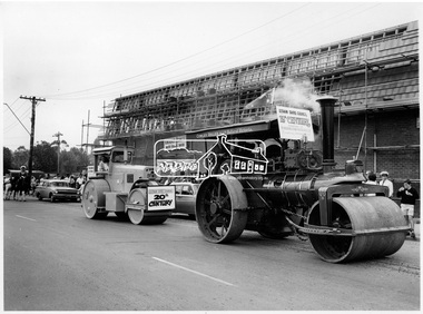 Eltham District Historical Society Inc
Photograph, Steam Roller and Diesel Roller. Procession of Floats Eltham, 10 Apr 1971
The Procession of floats travelled from the Eltham Shopping Centre to Eltham Lower Park on Saturday 10th April as part of the Shire of Eltham centenary celebrations program. A steam Roller and diesel roller. One of a series of three photgraphs. Participants in the parade included the Eltham Film Society, Scout group, Eltham volunteer fire brigade, riders on horses and horse and carts. A cowley roller from the Melbourne Steam traction engine club and a McDonald roller represented Eltham Shire Council in the 19th and 20th centuries. Another float includes a bark hut with trailer representing pioneers with a banner reading "The trues heroes our pioneers". Eltham Village is under construction by H.M. Keast & Sons, Master Builders. This photo forms part of a collection of photographs gathered by the Shire of Eltham for their centenary project book, "Pioneers and Painters: 100 years of the Shire of Eltham" by Alan Marshall (1971). The collection of over 500 images is held in partnership between Eltham District Historical Society and Yarra Plenty Regional Library (Eltham Library) and is now formally known as 'The Shire of Eltham Pioneers Photograph Collection.' It is significant in being the first community sourced collection representing the places and people of the Shire's first one hundred years.Digital imagesepp, shire of eltham pioneers photograph collection, shire of eltham, shire of eltham centenary, centenary celebrations, parade floats, parade, diesel roller, steam roller, h & m keast & sons, eltham village, main road, eltham, melbourne steam traction club -
 City of Moorabbin Historical Society (Operating the Box Cottage Museum)
Photographs, 7 x B&W Circa 1918 Cheltenham Methodist Youth Group, Circa 1918 Photos of Cheltenham Methodist Youth Group, 1918
Circa 1918: Various Photos of the Cheltenham Methodist Youth Group. Row 1 and 2: "At Flinders". Row 3: 1st Left, "Holidaying at Cockatoo". in 1852 Stephen Charman, who had arrived in Melbourne 1842 aged 21 years as one of Henry Dendy's emigrants, purchased 160 acres in Spring Grove ( now Cheltenham). Stephen and his family lived in a wattle and daub hut and worked hard to establish a market garden, poultry and pig farm. The first Methodist Church Services were held at their home. In 1855 Stephen gave 1 acre of his land on Balcombe Road to the Methodist Church for a School, Burial ground and a Chapel which was built in 1857.The Methodist Church, Balcombe Road was the 2nd religious building to be erected in Spring Grove now known as Cheltenham c 18577 small black and white photographs of the Cheltenham Methodist Youth Group at Flinders, Cockatoo and unkown locations, c 1918 . First 3 photos are of male cyclists on a trip to Flinders, Victoria. Photo 4 shows 6 ladies and a man on holiday at Cockatoo in the Dandenong Ranges ,Victoria . Photos 5 to 7 show men, women and children in bushland surroundings of unrecorded locations.Photo 1 - 3 on back : Flinders 1918 Photo 4 left on back : Holiday at Cockatoo right on back : Whitehead Photo 5-7 nilcheltenham, cheltenham methodist youth group, 1914, 1918, charman stephen, gettens mary, spring grove, methodist church, charman road, balcombe road, dendy henry, henry dendy's special survey 1841, youth groups, social groups, market gardners, early settlers, pioneers, dairy farmers, poultry farmers, pig farmers,moorabbin, brighton, -
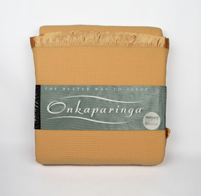 National Wool Museum
Textile - Onkaparinga Blanket, Waffle Collection, Unknown
Onkaparinga started in South Australia in 1869. Migrating from Germany, two brothers, Heinrich and Edward Kramm, both weavers, purchased and brought with them some machinery and established themselves in Hahndorf in a mud hut. Their original plant consisted of one carding machine, one spinning mule of 30 spools and 2 hand looms. The spinning mule was horse driven, the others all hand operated. The wool was washed by hand and dried in the sun then teased by hand. Now 145 years later the brand name Onkaparinga, is known all over the world, the products reflect the experience, passion and ingenuity of over a century's tradition in providing luxurious home wares. Donated to the National Wool Museum by Joyce GrayLight orange waffle weave woolen blanket, with nylon trimming. Product tag included with plastic case. On product tag - The better way to sleep. Onkaparinga onkaparinga, blanket, wool, kramm -
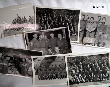 Bendigo Military Museum
Photograph - PHOTOGRAPHS, MILITARY, 1950’s to 1961
The photos are part of a large collection relating to Francis William (Dinky) DEAN BEM, VX93960 2nd AIF, 3742 1 RAR, 1943 - 1975. Refer Cat No 124.2 for his service history. (.1) Frank Dean first in front on the left. (.2) “”””””””” rear row 2nd from the right. (.3). “”””””””” first on the left. (.5) “””””””””” front row third from right. (.6 .7.9) Each of these group photos have either several Korean or Malayan soldiers in. The photos are possibly the Platoons of either A or D Coy’s 1 RAR. (.8) Frank Dean, front row 2nd from the left. This group is possibly the Officers and senior NCO’s of A or D Coy’s 1 RAR. All photos are B & W. (.1) Large group of soldiers on parade with .303 rifles on the march. (.2) group of 7 soldiers , 5 standing 2 sitting. (.3) Group of 5 soldiers standing with a sign “D Coy Sgt’s”. (.4) Group of soldiers at a dinner in a Nissan hut all standing. (.5) Group of 18 soldiers, 1 row standing, 1 sitting in front of a RAAF plane. (.6) Group photo of 24 in 3 rows. (.7) Group photo of 22 in 3 rows. (.8) group photo of 14 in 2 rows. (.9) group photo of 26 in 3 rows.photography, military -
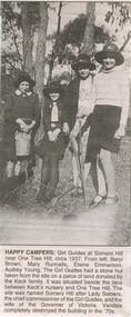 Bendigo Historical Society Inc.
Newspaper - JENNY FOLEY COLLECTION: HAPPY CAMPERS
Bendigo Advertiser '' The way we were''from 2002. Happy campers: Girl Guides at Somers Hill near One Tree Hill, circa 1937. From left: Beryl Brown, Mary Runnalls, Elaine Emmerson, Audrey Young. The Girl Guides had a stone hut taken from the site on a piece of land donated by the Keck family. It was situated beside the race between Keck's nursery and One Tree Hill. The site was named Somers Hill after Lady Somers, the chief commissioner of the Girl Guides, and the wife of the Governor of Victoria. Vandals completely destroyed the building in the 70s. The clip is in a folder.newspaper, bendigo advertiser, the way we were -
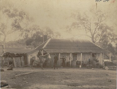 Bendigo Historical Society Inc.
Photograph - FARMHOUSE NEAR MT SUGARLOAF - SLAB HUT, c.1880
Sepia photograph. Slab hut with bark roof, verandah. One brick chimney, weatherboard skillion at L end. One male under verandah. One male in yard. One male mounted on horse. Barrels, wheelbarrow, four wheeled horse drawn vehicle under or near verandah. Inscriptions on front 'MP94', in red ballpoint ink '28'.On Back in grey lead 'Axedale family near Sugarloaf'.( near Fosterville ) On back in red ball point pen '28'. History of object: Previous Acc. No. 'MP 94'. An important photo of early settlers showing type and construction of farmhouse, type of farm implements and clothingBendigo Advertiserbuildings, residential, cottage -
 Bendigo Historical Society Inc.
Photograph - QC BINKS COLLECTION: CLIFF BINKS IN FRONT OF MRS. KEATH'S BOARDING HOUSE
(2) Copy of original : image shows man standing on footpath leaning on gate post of house. Notation: Cliff Binks in front of Mrs. Keath's boarding house located at 270 High Street, Bendigo. Had 6 boarders. Mrs. Keath ran the very good boarding house with her daughter's help. Grenfell's two storey (residence above) butcher's shop is on far left of photo - next to Hawley's Grovers shop, now pizza hut. 1938. Note with photos 'Bruce Mainka personally paid Cliff Binks $3.30 for these unsolicited photocopies. Donated to BHS by B.G. Mainka but recorded as a purchase'person, individual, cliff binks, binks, bendigo, keath, grenfell, hawley -
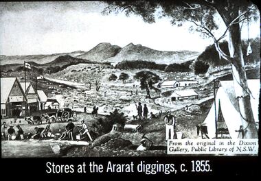 Bendigo Historical Society Inc.
Slide - DIGGERS & MINING. STORES AT THE DIGGINGS, c1855
Diggers & Mining. Stores at the diggings. Stores at the Ararat diggings, c. 1855. From the original in the Dixon Gallery, Public Library of NSW. Slide depicts the scene at the goldfields with the Commissioners huts and in the background there are other buildings. On the Gold field there is a man on a horse, a man with a heavily laden cart being pulled by 4 ox. Some men are working in the gully for gold, panning, using cradle. In the front centre at the bottom is the head and shoulders of a man with an axe digging out his mine. There are also some dogs in the picture and a tent in the front right corner. Markings: 12 994.LIF. 5. Used as a teaching aid.hanimounteducation, tertiary, goldfields -
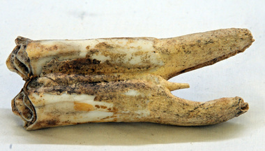 Orbost & District Historical Society
tooth
This was dug up at the old station at Lochend owned by the Stirling family and abandoned in the early 1870's. James Stirling's son Thomas Telfer Stirling took up the Corringle Run stretching from Lake Tyers along the coast. The home was at the Old Station. When he moved to Bruthen, James Stirling took over the Corringle Station. He is buried in the Marlo cemetery. He built a bark hut on the bluff that had two rooms, bark walls, earthen floors and a shingle roof. By 1884, this structure had expanded to a 9 roomed accommodation house and in 1886 became the Marlo Hotel when a liquor license was granted. info. from Personalities and Stories of the Early Orbost District by Mary Gilbert. The first settler to occupy the Marlo township area was James Stirling around the year 1875.An old horse tooth. Probably from before 1920. It is a molar.tooth stirling molar equine -
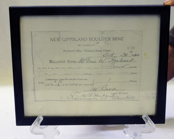 Orbost & District Historical Society
Certificate - share, 30/10/1940
Share certificate issued by New Gippsland Boulder Mine - operating at Errinundra and receipt for Herbert, Eric W. Receipt is for amount of four pounds - signed by Bird, W. Prospectus was printed in 1934 at office of Snowy River Mail - 4 page booklet. Gold, copper and silver were the target minerals.The crusher from the Boulder Mine is now at the Slab Hut in Orbost. The first Gippsland Boulder Co.,was at Boulder Creek – 13 miles north of Club Terrace, within 2 miles of Errinundra River. The company registered in January 1898 and commenced crushing in September with a 10-head battery. In the first nine months’ yields totalled 1,418 oz from 972 tons.There was a tramway between the mine workings and the battery.The crusher from the Boulder Mine is now at the Slab Hut in Orbost. This document is a reference for gold mining and exploration in the Far East Gippsland area. The Herbert family has reside in Orbost since the late 19th century.Copy of New Gippsland Boulder Mine share certificate and receipt. Framed in small black wooden frame.certificate-share-new-gippsland-boulder-mine mineralogy mining boulder-creek -
 Wodonga & District Historical Society Inc
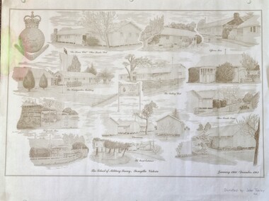
Work on paper - Sketch - The School of Military Survey, Bonegilla
Bonegilla operated as an army base from September 1940 and by 1943 was expanded to 848 buildings, including a general hospital. It provided training for small arms instructors, signallers, transport workers, bomb disposal and gas warfare personnel. In a response to the need to house the growing number of displaced persons coming to Australia, the Bonegilla Reception and Training Centre began operating in 1947. For some time it was a shared facility but the Army withdrew temporarily from Bonegilla in 1949, whilst still retaining ownership of the site. From 1949-65 Bonegilla Reception and Training Centre operated without a military presence. However, in the late 1960s and Australia’s commitments to the Vietnam War and pressed by the need to find accommodation to train men, especially National Servicemen, the Army negotiated with the Department of Immigration to take over several blocks at Bonegilla in 1965. Thirty-five huts were acquired by the Royal Australian Army Ordnance Corps as a Recruit Training Centre in which National Servicemen and recruits could attend 10-week ordnance courses. Shortly afterwards additional huts were acquired by the School of Military Survey, which established field-survey practical training areas and special astronomical observation sites as it began conducting courses in surveying. Instructors and trainees co-located at Bonegilla with migrant reception centre. In 1971 the Reception Centre closed and the site reverted to the Army. Progressively after 1971 the Army undertook a major site redevelopment with the construction of Latchford Barracks as the Army Apprentice School. Later Latchford Barracks was redeveloped into part of the Army Logistic Training Centre. Block 19 of the Mirant Reception Centre later became the Bonegilla Migrant Experience Heritage Park.This item depicts a heritage listed historical site located in the Wodonga district.A large poster size representation of the variety of buildings at Bonegilla, Victoria when it served as the location for the Royal Australian School of Military Survey. The insignia of the Royal Australian Survey Corps is featured in the top left hand corner.Top left corner: Insignia of the Royal Australian Survey Corps At bottom of sketches: "The School of Military Survey, Bonegilla Victoria / January 1966 - December 1982migrant reception centre bonegilla, army at bonegilla, australian military -
 Bendigo Historical Society Inc.
Photograph - PETER ELLIS COLLECTION: PHOTOS, 14th January, 1897
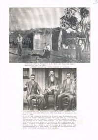
Two black and white photos pasted onto a sheet of paper. The top photo is a photo of three men, one playing a fiddle, one with a brass instrument and the third is not very clear. They are in front of a hut with branches on the roof and hessian walls. Beneath the photo is typed on a piece of paper - A Bendigo Camp by Mulgarrie W. A. (Boer War Training Camp? Bendigonian Jan. 14 1897. Latrobe Collection, State Library of Victoria. The second photo is three men, dressed in suits and sitting on chairs in front of a building. One has a clarinet, the middle one has a concertina and the other has a fiddle. The men are the Coleman Brothers. The photo was taken by a travelling photographer called Siebart.photo, group, male, peter ellis collection, mulgarrie w a, boer was training camp?, bendigonian 14/1/1897, latrobe collection, state library of victoria, bill coleman, charles coleman, john robertson, singabout vol 6 no 1 1966, siebart, peter cuffley -
 The Beechworth Burke Museum
Photograph, Late 1900s
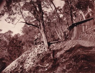
This photograph dating to the late 1900s depicts the entrance to a reef mine the in Beechworth division. The image depicts two men outside the entrance, which is covered by a hut, where one is standing near a mine cart. The mine car was used to haul soil from the mine. The Beewchworth divison consisted of 5 locations: Beechworth, Stanley, El Dorado, Hurdle Flat and Stony Creek. These locations were set up due to speculative fever that more gold could be found. In places such as El Dorado, Beechworth and Stanley there was profit, however Hurdle Flat and Stonry Creek, gold could not be found in the quantities that was required. By 1880 the Beechworth division was in depression due to the reserves being used up. However, in spite of the depression mining was continued until the late 20th Century.The search for gold is ingrained into the history of Victoria and therefore, images like this one which portray an open cut sluicing site can reveal important information for society and technology for the date when the photograph was taken. This image is of important historical significance for its ability to convey information about reef mining in the late 1900s. It also shows a location where reef mining was undertook which provides insight into the impact of reef mining on the environment at a time when it was done. This image is important for current research into the history of Beechworth , a town in Victoria's north-east. Therefore, this image has the capacity to be beneficial for research into society and the motivations of those living and working in this region during this period and therefore, has social significance. The Beechworth Burke Museum has additional images relating to reef mining and Beechworth which can be analysed and studied alongside images like this one.Sepia coloured retangular photograph printed on newspaper.Reverse: 7813beechworth, beechworth division, mining, reef mining, gold, gold mining, 1990 -
 The Beechworth Burke Museum
Photograph, 1865
Taken in Beechworth 1865, this photograph depicts the view of the Spring creek with the Beechworth township in the background. This photograph was taken 13 years after the discovery of Gold at Spring Creek. Within eleven months of the discovery in 1852, over 8000 hopeful prospectors had descended on the region, transforming the seemingly undisturbed land into what a visiting journalist in 1880s referred to as; "A Titan's Field". Huge mounds of earth were churned by hundreds of miners in search for gold, almost every available resource the land had to offer was used for something; even the bark off the gums were stripped to line huts and shafts. By 1857 more than 20,000 people lived in Beechworth, and with this influx the town prospered with the building of numerous churches, banks, schools, shops and hotels along with a prison and hospital.Black and white rectangular photograph. Image is printed on matte photographic paper and is mounted on cardboard.Obverse: NO INSCRIPTION Reverse: BMM6925 / BEECHWORTH FROM SPRING CREEK 1865 beechworth, spring creek, gold rush, titan's field, 1865, prospectors -
 Federation University Art Collection
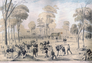
Print - Printmaking - Lithograph, Tulloch, David, 'Great Meeting of Gold Diggers Dec 15th 1851' by Thomas Ham, 1852
One of the first large goldfield meetings was at Castlemaine in 1851. After the extraordinary success of the Mt Alexander Diggings the Government issued a proclamation, raising the licence fee from thirty shillings to three pounds. As soon as these intentions became known a public meeting of miners was held. For miles around work ceased, with diggers travelling as far as Bendigo to attend the meeting. It is estimated that around 18,000 people attended the meeting. The notes with the engraving state The trees in this locality are chiefly Stringybark; some of them are peeled of their covering, as many persons prefer erecting bark huts to living in a comfortless tent. The various groups, and costumes of the men, are characteristic of our gold digging community. This item is part of the Federation University Art Collection. The Art Collection features over 2000 works and was listed as a 'Ballarat Treasure' in 2007.Colour lithograph of a meeting of diggers at a meeting in Mt Alexander. The meeting was the result of goldfields agitations against the license fee. lower centre "Great Meeting of Gold Diggers Dec 15th 1851" lower left side "Drawn By D. Tulloch" lower right side "Engraved by Thomas Ham"art, artwork, ham, thomas ham, tulloch, castlemaine, goldfields agitation, printmaking, edition, coloured lithograph, david tulloch, gold pan, shovel, wheelbarrow, waggon, bark hut, ring barked tree, gold mining -
 Phillip Island and District Historical Society Inc.
Photograph - Post Cards, F & J Postcards, Early 20th Century
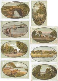
1 sheet of a collection of 15. Copies of Postcards of Phillip Island from the Shirley Jones Collection.Reproduction of 8 postcards taken around Phillip Island. 326-01A. Phillip Island Forrest Caves. F & J 326-01B. "SS Genista" CAlling at Newhaven - Phillip Island 326-01C. Wool Team on road to Cowes - Phillip island 326-01D. Fisherman's Hut Cowes - Phillip Island 326-01E. Lovers Walk Cowes - Phillip Island 326-01F. Cowes Jetty. Govt. Steamer "Lady Loch" in distance - Phillip Island 326-01G. Cowes from Steamer - Phillip Island 326-01H. Milking time Newhaven - Phillip Islandphillip island, lovers walk cowes phillip island, forrest caves phillip island, ss genista, wool team cowes phillip island, fisherman's hut cowes, lady loch steamer, cowes phillip island, milking time newhaven, shirley jones collection, thelma astbury -
 Ringwood and District Historical Society
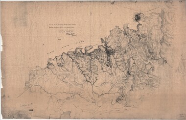
Map, Survey of Dividing Range between Yarra Yarra and Western Port - William Wedge Darke, 1843
Extract - Ringwood, Place of Many Eagles - Hugh Anderson (1974): William Wedge Darke, from Hereford, England, was a nephew of John Helder Wedge of the Port Phillip Association, who was also a surveyor. William's most important work was probably his survey of the Dividing Range and the country between the Yarra River and Western Port, completed in May 1843, and during which he made a traverse between the Mullum and Dandenong creeks along the higher ground that he labelled the "best line of road from Melbourne". This road was for many years the major route to Gippsland and to the higher country about Alexandra and Mansfield, sometimes known as White Horse Road, and now Maroondah Highway.Surveyor's relief map of features to the east of Melbourne including Yarra Yarra River, Mullum Mullum Creek, Anderson's Creek, Dandenong Creek.Transmitted to the Surveyor General with my letter of 10th May 1843 (signed) Wm Wedge Drake, Assistant Surveyor. Scale: two inches to a mile. Descriptive remarks include upstream area of Yarra River - "impassable, appears to have been formerly a lake", and to the south - "barren and scrubby swamps of the Western Port Country". Marked tracks include "best line of road from Melbourne", "track to Dandenong", "Road to Port Albert may probably be found on this range", "Best line to Upper Yarra". Several huts also marked. -
 Falls Creek Historical Society
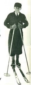
Equipment - Martin Romuld's Skis
Martin Romuld was born near Trondheim in Norway on September 26, 1905. He started jumping on skis at age 6 or 7 and became very good at it. He completed his degree in Civil Engineering at the University of Trondheim and decided to come to Australia. He arrived on 7 March 1928 and found a job with the SEC. The SEC wanted to investigate the possibility of a hydrological surveys necessary to determine the flow of water over a period of years. These surveys started in 1934 and continued until 1941. He lived at Wilkinson’s hut for most of the time during those years both in summer and winter. In his role with the SEC, Martin visited all the various creeks to measure water flow rates as often as was necessary. These skis were used on his winter rounds during the time he spent in the area. Martin also competed in skiing during the 1930s. He won the combined Australian title 3 or 4 times. He was unbeatable in cross country, probably due to the continual practice in his job. Before migrating to Australia, Martin had been runner up in the 1926 European Jump Championships held in France. Jumping was his favourite thrill and he would often construct a jump for practice near the Scout Hut (or Rover Chalet) quite near to Wilkinson’s. In 1941 Martin joined the Royal Australian Air Force and after the War skied mainly at Mt Buller. He maintained his involvement in competitive skiing as an official. In 1958 Martin was the main judge of the National jump which was held to the left of the Nissen tow. He also designed the jumping course at the Donna Buang snow fields. Martin Romuld was Co Vice-President of the Federation of Victorian Ski Clubs in 1949, along with Tom Mitchell M.L.A. Martin Romuld died on 14 July 1998 in Prahran, Victoria,These skis are significant because they belonged to a pioneer of Falls Creek and the sport of skiing in Australia.A set of skis made for Martin Romuld. They are made from American hickory which arrived in Australia via Norway in October 1933. Andy Broad made the skis and they were furnished with steel edges. There was enough hickory for 18 pairs of skis and a pair of competition cross country skis were also made for Martin Romuld. martin romuld', falls creek pioneers, australian skiing history -
 Falls Creek Historical Society
Photograph - Jack Maddison Leading horses on the Bogong High Plain
The images in the Bogong Village Collection were displayed in Bogong Jack’s Tavern for over 20 years and were donated to the Falls Creek Museum when the Tavern closed in 2021. In 1939, the State Electricity Commission of Victoria established a field headquarters at Bogong to house workers and their families for the Kiewa Hydroelectric Scheme which ran from the 1930s to the 1960s. The workmen's camp was originally started with tents and was called Junction Camp. By 1947, the village supported 300 workers and their families. It included 40 houses, a hostel for single staff, a post office, a police station, a medical centre, and a primary school. The staff hostel was known as Kiewa House. At the completion of the Scheme, in the 1960s, the village was opened to public/tourism use. In 1968 the Victorian Education Department acquired the camp buildings and four houses from the State Electricity Commission of Victoria to establish an Outdoor Education Centre which operated for over 50 years. The Kiewa Hydroelectric Scheme was privatized in the 1990s and sold to Southern Hydro, before being acquired by AGL in 2005. In 2023 the Grollo Group signed a 73 year sublease on Bogong Village and has plans for its redevelopment as a workers’ village. John Maddison and his wife Mary Padman emigrated from London to Australia in 1850 with their five sons. Jack (John James William Maddison) was one of their great grandsons. In 1877 Jack’s grandfather George Maddison selected land between the East and West Kiewa branches of the Kiewa River - known as the "Island". It is now known as Mount Beauty. The Maddison family built Aertex Hut at the top of T Spur at Mt. Bogong for use when grazing cattle. It later became known as Maddison's Hut. Staircase Spur walking track at Bogong was formerly known as Maddison’s Track as it is the path once used by the Maddison family to drive their cattle on to the high plains. These images are significant because they feature the son of a pioneering family on the Bogong High Plains.A black and white photograph of Jack Maddison leading horses on the Bogong High Plains.bogong alpine village, bogong high plains, maddison family mt beauty, maddison's hut, aertex hut, -
 Falls Creek Historical Society
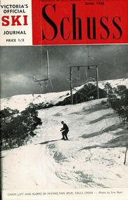
Journal - Schuss Vol. 24. No.4 June 1958
Schuss was advertised as Victoria’s Official Ski Journal It was issued monthly from 1935 to 1961 except during the war when summer issues covered two months. This continued after the war, but it averaged 10 issues annually over its 25 year life. Schuss was published by the Ski Club of Victoria which had a membership of 38 Ski Clubs and demanded to be recognised as the prime authority on skiing in the state. The other 30 ski clubs with 85% of the members disagreed and the politics of skiing became heated. These clubs formed the Federation of Victorian Ski Clubs with their own journal, Ski Horizon. With the establishment of the Victorian Ski Association, Ski-Horizon published its last issue in Nov - Dec. 1955 and the role of the official journal was fully taken over by “Schuss”. This item is significant because it contains stories, images and information documenting the development of the ski facilities at Falls Creek.The journal features stories and events chronicling developments in Victoria and internationally. The cover features a photo of the Chair Lift and Slopes of Frying Pan Spur by Eric Burt. Page 130 again included an advertisement for Snow Crystal Inn managed by Milan Kovacic and page 133 advertised vacancies at Grand Coeur Chalet. A memorial notice for the death of George Fitzgerald of Shannonvale, a pioneer of Omeo, Victoria, builder of Fitzgerald Hut is on page 137. A brief description of the beauty of Bogong Township in Autumn is on page 140 and a short article describing Falls Creek - Gateway to the High Plains is found on page 155. On page 166 developments made in Falls Creek since the previous winter are explained.schuss journal, the ski club of victoria, george fitzgerald of shannonvale, frying pan spur, falls creek 1958 -
 University of Melbourne, Burnley Campus Archives
Album - Colour Photographs, Peter Esdale, Photograph collection, c. 1992
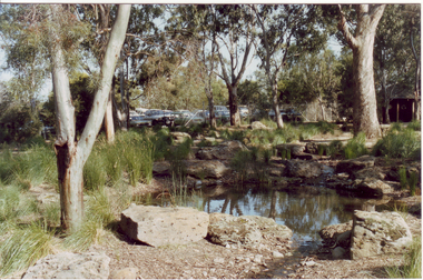
Possibly taken by Peter Esdale; work commenced 1989.13 colour photographs of the Woodland and Robert Boyle Ponds and other views of Burnley. (1) View of the Robert Boyle Ponds and the Mud Hut, looking towards the car park at the back. (2) View of the Robert Boyle Ponds looking towards the car park at the back. (3) View of Grassland. (4) Close up of Grassland. (5) Close up of plants. (6) Close up of plants. (7) Grass trial beds in Field Station. (8) Administration Building. (9)Inside the Nursery. (10) Close up inside the Nursery. (11) Close up inside the Nursery. (12) Laboratory. (13) Award Cabinet inside the Administration Building. (The contents are now missing.)woodland, robert boyle ponds, burnley, mud hut, grassland, plants, field station, administration building, nursery, laboratory, award cabinet, administration building, grassland trials -
 Bendigo Historical Society Inc.
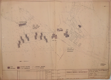
Plan - SANDHURST BOYS CENTRE COLLECTION: MASTER PLAN
Government of Victoria. Public Works Department. Master plan for the Loddon-Campaspe Regional Service Sandhurst Centre. [produced by] J Swan Chief architect, approved by B.W. Swan. Shows a brick Administration building, 6 [accommodation?] brick buildings (to be remodelled), the site for a new kitchen & amenities building, TDU no 1, BMU, TDU no 2 (new buildings), sites for maintenance workshops, vegetable garden. Also shows a residence, garage, recreation oval, with 3 existing weatherboard buildings, galvanised iron building, a weatherboard grandstand, a galvanised iron shed, fowl shed, 14 galvanised iron buildings [probably Nissan huts] and 2 toilet blocks. Location unknown 16.02.2023.bendigo, institutions, sandhurst boys centre, victoria public works dept; plans; sandhurst boys centre; j.swan