Showing 2327 items matching "parishes"
-
 Bendigo Historical Society Inc.
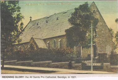
Newspaper - JENNY FOLEY COLLECTION: REIGNING GLORY
All Saints in McKenzie Street was opened in 1856 (nave) and was the Anglican Parish Church until 1902 when the Bendigo diocese was established. At this time it was designated a cathedral. In 1981, St Pauls in Myers street became the new cathedral and All Saints was eventually closed in 1989.Bendigo Advertiser ''The way we were'' from 2002. Reigning glory: the All Saints Pro Cathedral, Bendigo, in 1921. The clip is in a folder.newspaper, bendigo advertiser, the way we were -
 Federation University Historical Collection
Plan, Department of Crown Lands and Survey, Melbourne, Buninyong County of Grant, 23/07/1929
The plan was photo-lithographed at the Departmen tof Lands and Survey, MelbourneA parish plan of Buninyong, including Robert Scott's Mt Buninyong Pre-emptive Right, Mt Buninyong Public Park, Thomas Learmonth's land, John Learmonth's land, Scotchan's, Yendon. The Buninyong POst Office is Allotment 1. Pisition of tracks in 1859 have been marked on the plan in red.buninyong, scotchman's, mt buninyong, robert scott, clarendon, lal lal creek, yendon, warrenheip, yarowee, enfield, thomas learmonth, john learmonth, archibald fisken, g. schloo, george innes, peter inglis, durham lead, j. fry, j. forrest, parkin lee, buninyong recreation reserve -
 Bendigo Historical Society Inc.
Document - LYDIA CHANCELLOR COLLECTION: THE UNITING CHURCH IN AUSTRALIA BENDIGO WEST PARISH FOREST ST CONGREGATION LETTER, 1993
LYDIA CHANCELLOR COLLECTION: The Uniting Church in Australia Bendigo West Parish Forest St Congregation Letter To the Congregation Members 12th August 1993 from Ruth Hosking Secretary, Council of Elders. A Comprehensive description of a proposed outreach ageny of the Uniting Church to be known as 'Bendigo Uniting Church Outreach'bendigo, history, churches -
 Bacchus Marsh & District Historical Society
Map, Lerderderg District Proposed Irrigation and Water Supply Trust (A). Plan showing boundaries of Trust District
The 1886 Irrigation Act in Victoria introduced the first legislation in Australia designed to enable the creation of a detailed scheme for agricultural irrigation. Part of the legislation saw the use of government funds for local irrigation projects. These local projects were managed by local irrigation trusts. The Lerderderg Irrigation and Water Supply Trust] was formed in 1890. This map depicts the proposed area of the Trust.Printed paper map of the proposed Lerderderg District Irrigation and Water Supply. Plan showing boundaries of Trust District. The Lerderderg District lies within the Parishes of Korkuperrumul and Merrimu in the County of Bourke. At the top of the map above its title is the letter 'A; in capital lettering. Scale: 40 Chains = 1 inch.irrigation, water supply, lerderderg irrigation and water supply trust -
 Bacchus Marsh & District Historical Society
Map, Limestone Reserve Parish of Merrimu 1888
Limestone deposits in the Coimadai area 10 kilometers north of Ballarat were first worked in the 1850s. The area was quarried for limestone for many years by various people and companies. The surveyor's name who produced this plan is inscribed on the map and below this is the name P. L. Alkemade, who presumably paid for the map to be produced. In 1886 Petrus Alkemade in partnership with Matthew Egan established the Alkemade Hydraulic Lime and Cement Company. The Alkemade family were involved in the limestone industry over several generations at Coimadai.Single page map showing part of the Limestone reserve near Coimadai in the Parish of Merrimu. Scale 4 chains to 1 inch. Part of a set of maps which are pasted into a bound volume containing 76 maps or plans in total. High resolution digital image stored on BMDHS computer network. Copy of plan surveyed by Mr. G? [illegible] an authorised surveyor on 17th July 1888. P. L. Alkemadebacchus marsh victoria maps, lime kilns coimadai, limestone, coimadai victoria maps, alkemade family coimadai -
 Ringwood and District Historical Society
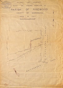
Map, Plan of Survey, Part of CP12, Adelaide Street, Ringwood, Circa 1920s
Undated map of part of commercial area in Parish of Ringwood, County of Mornington showing Adelaide Street, Whitehorse Road, and un-named laneway behind Whitehorse Road shops marked as Road, and New Road Alignment. Made by H.J. Macey, Licensed Surveyor 36 Narissa Street Burwood BX1917. -
 Ringwood and District Historical Society
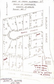
Map, Subdivision Plan - Adam Court area, North Ringwood, Vic. - circa 1960s
Single page plan printed showing allotments included in un-named subdivision layout surrounding Adam Court, Ringwood North. Subdivision includes Adam Court, Burlock Avenue, and Felix Crescent. Sold allotmenets marked in red, with price notations.Page heading - Part of Crown Allotment 27B Parish of Warrandyte County of Evelyn Scale 60'-1". Rubber stamp imprint and handwritten address at bottom of page - "Binburra Estates Pty. Ltd. 23 Pitt St., Ringwood, 870-1184". -
 Federation University Historical Collection
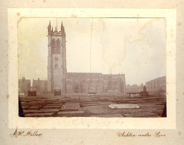
Photograph - Photo, J.W. Mellor, St Michael's and All Angels church and cemetery, Ashton-under-Lyne
The Church of St Michael and All Angels dates from the 15th century and is the Parish Church for Ashton under Lyne. It is believed there was a church on this site before the Norman Conquest as the Domesday Book mentions a St Michael's Church in the east of the ancient parish of Manchester. Much of the structure was re-constructed in Victorian times. The church with large windows in Perpendicular style. Buttresses were required with this type of building as the large window area reduced the strength of the walls. The church boasts boasts some of the best examples of fifteenth century stained glass left in Britain. There are eighteen panels illustrating the life of St. Helena. The church tower is 145 feet high and has a peel of thirteen bells. (From ashton-under-lyne.com) .1) Sepia photograph mounted onto card showing St Michael's and all Angels church and graveyard in Ashton-Under-Lyne. The gravestones shown in the photograph are no longer evident today. The cemetery area is now covered with grass.cemetery, st michael s and all angels, ashton under lyne, j w mellor, church -
 Kiewa Valley Historical Society
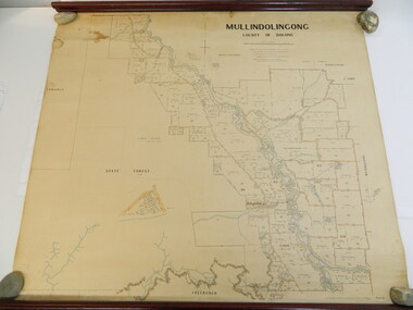
Map - Kiewa Valley, Parish Map of Mullindolingong, 12/10/1906
The map shows the names of people living in the parish of Mullindolingong in 1906. These people had leases or licences giving the reader an insight into the number of people in the area and an understanding of the size of their holdings. Infrastructure is also given including shops, schools, churches etc. Presumably it was used by the Ryder family.This map gives an historical insight into the parish of Mullindolingong as it names people and the infrastructure - roads, buildings etc. as it was in 1906. This enables the reader to compare the area at the time with other times and other places and to have an understanding of the early settlers in the area.This is a very old paper or parchment map with wooden rods top and bottom. The top rod has ribbons attached to enable hanging. The map shows the current leases and licences and when they were held by during this period, circa 1906.Mullindolingong County of Bogong. This plan has been prepared by The Most Reliable Data in the Possession of the Department up to the date of its Compilation. Information respecting Leases or Licences which await Final Completion is not recorded.parish of mullindolingong map; ryder family; early settlers; -
Glen Eira Historical Society
Article - St. Catherine’s Church of England, Kooyong Road, Caulfield South
Three items about this Church: 1/St. Catherine’s Parish paper, February 1924. 2/Baptismal prayer card for Harry Norman Bromfield 08/03/1925. 3/Carbon typed copy of document detailing inscriptions in St. Catherine’s Anglican Church Caulfield.st. catherine’s church of england, st. catharine’s church of england, caulfield south, kooyong road, clarence street, stephens mr., debb dr., murphy mr., booth e., masters p., kindergartens, paterson mrs., fowler mrs., capper mrs., mayes mrs., olley mrs., hosken mrs., schwieger miss, walker mrs., ward mrs., foster mrs., marshall mrs., marsh mrs., hearn miss, stephens h., downshire road, bromfield harry norman, taylor alice mary, wigg catherine elizabeth, stephens grace m., beagley emily a., beagley joseph e., beagley emily ada, parrott frances catherine, wilson alfred roscoe, hamilton flora, hillard john beattie, hillard thomas, haillard eliza, barlow w., begbie a.h., cole s., love j., north h., tonks h., scammell s., hunt geoffrey donald, myer leslie robert irvine, forbes betty, mcavoy alan robert, humphreys betty grace, marke alfred robert, bromfield norman edward, reed margery eva, philpot elizabeth ann, dillow henry thomas, murphy mr., taylor mr., booth mr., drewett mr., hickson mr., ingram mr., lumsden mr., meyer mr., nutt mr., summerhayes mr., mcclure j., segal boris -
 Greensborough Historical Society
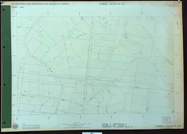
Map, Melbourne and Metropolitan Board of Works. Survey Division, MMBW, Yarra 2500 / 14.25. Plenty, Heard Road, 1978_02
Melbourne and Metropolitan Board of Works. Yarra 2500 [base map] 14.25. Plenty, Heard Road. Parishes of Greensborough 2724, Nillumbik 3310 and Morang 3183. Municipality of Diamond Valley 257. Prominent streets include: Heard Road, Seymour Drive and Yan Yean Road.MMBW Map in 1:2500 [scale] series. Cream parchment with green tape reinforcing on edges and punched holes on left edge.mmbw, melbourne and metropolitan board of works, shire of diamond valley, plenty - maps -
 Kiewa Valley Historical Society
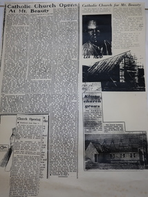
Booklets and Papers - St Joseph's Catholic Church Mt Beauty, St Joseph's Catholic Church Mt Beauty Golden Jubilee 1954-2004
Catholics from Tawonga attended Mass at Dederang the area being part of the Myrtleford parish. With the coming of the State Electricity Commission and the increase in population Masses were said in various schools, homes and halls between Tawonga and Mt Beauty until the completion of St Joseph's ChurchSt Joseph's Catholic Church, Mt Beauty was consecrated on November 7th 1954. The SEC allocated land to each of the churches for them to provide their own places of worship. It was built by volunteers who donated money and their time to raise funds and build the church.1. Booklet with yellow cover, black print and 28 pages back to back held by 2 staples. 2. Booklet "Mass to Celebrate the 40th Anniversary of St Joseph's Church Mt Beauty 1954-1994" 4 pages back to back 3. Papers: vary - 1. A3 sheet with articles from newspapers "Catholic Church Opens At Mt Beauty"; "Catholic Church for Mt. Beauty". 2. x4 A4 sheets typed back to back -"Recalling the first 40 years" 3. St Joseph's Mt Beauty 1968-69 Lawn Cutting Roster 4. Miscellanious st joseph's mt beauty, catholic church, golden jubilee, religion -
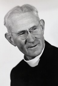
 Uniting Church Archives - Synod of Victoria
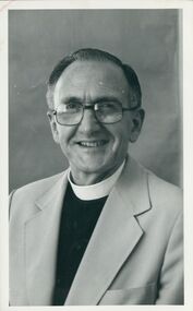
Photograph, Undated c.1985
Reverend Ron Upson was elected unopposed as Moderator of the Tasmanian Synod. Reverend Upson was in 1985 at Launceston South. He was ordained in Western Australia in 1970 and served in three parishes before working in Samoa first at Piula Theological College then as connexional secretary for the Methodist Church in Samoa.Reverend Ron Upson and Reverend J. Pethie seated at a table in front of a church pulpitRev. R. Upson Rev. J. Pethie sheet 1 no 2upson, ron, rev., pethie, j. rev., moderator, synod of tasmania, uniting church minister -
 Uniting Church Archives - Synod of Victoria
Photograph, Peter Davis, undated
Reverend Peter K. Davis was ordained in 1954. He served at Nimbin, Milton and in Fiji. He was President of Conference between 1969 and 1971, served at Gladesville, Newtown, Overseas Mission (CFWM), Wesley Central Mission and Leichhardt-Petersham Parish Mission. He retired in 1992.B&W head and shoulders photograph of Rev. Peter Davis."Peter Davis Jan 80"davis, peter k., methodist, wesley central mission, president of conference. -
 Bendigo Historical Society Inc.
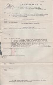
Document - H. A. & S. R. WILKINSON COLLECTION: CONTRACT OF SALE
Contract of sale of land by public auction dated 17th March 1956 between Mr. Kevin Daniel Bourke (vendor) and Ms. Evelyn Mary Pook (purchaser). Solicitor for vendor: Hogan & Hogan, Bendigo. Solicitor for purchaser: Hyett, Willis & Hyett, Bendigo. Property: 112 Victoria Street, Eaglehawk being land firstly part of Crown allotment 11 section 17 Parish of Eaglehawk land described in certificate of title volume 2467 folio 304. Secondly part of Crown allotment 10 section 17 Parish of Eaglehawk, land coloured red on the plan hereon being part of land comprised in certificate of title volume 4416 folio 036. Price 1,100 pounds.organization, business, h.a. & s.r wilkinson real estate -
 Bendigo Historical Society Inc.
Document - H. A. & S. R. WILKINSON COLLECTION: CONTRACT OF SALE
Contract of sale of land dated 31st May 1956 between Mr. Kevin Daniel Bourke (vendor) and Ms. Evelyn Mary Pook (purchaser). Solicitor for vendor: Hogan & Hogan, Bendigo. Solicitor for purchaser: Hyett, Willis & Hyett, Bendigo. Property: 112 Victoria Street, Eaglehawk being land firstly part of Crown allotment 11 section 17 Parish of Eaglehawk land described in certificate of title volume 2467 folio 304. Secondly part of Crown allotment 10 section 17 Parish of Eaglehawk, land coloured red on the plan hereon being part of land comprised in certificate of title volume 4416 folio 036. Price 1,100 pounds. Photocopy of office copy.organization, business, h.a. & s.r wilkinson real estate -
 Federation University Historical Collection
Plan, Haddon, County of Grenville, 1932, 13/04/1932
The Haddon Parish Plan shows crown parcels government roads, Crown Reserves, Railway. Scale 40 chains to 1" (1:31, 680) WGS 84 Centroid Lat: 37 degrees 34' 00" S Long: 148 degrees 40' 20" E N.S. 9.3km E.W.: 16.1kmhaddon, grenville, cardigan, water supply reserve, nentingbook pre-emptive right, a. mclachlan, lake burrumbeet, e.a. wynne, p. russell, b. hepburn, benjamin hepburn, nentingbool, t.c. wilson, j. amoy, william collard smith, james roach, j. mitchell -
 Bendigo Historical Society Inc.
Document - E DOWLING COLLECTION: MARRIAGE CERTIFICATE
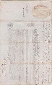
Marriage certificate of John Scott Lithgow and Mary Matilda Lithgow. Marriage by licence. Parish church of Morden in the county of Dorset, diocese of Sarum. Date 20 December 1848. Bachelor and spinster, both 21 years of age. T.R Capel, surrogate. Fitz Macdonald, registrar. Possibly related to the Weir familygenealogy, family, lithgow, john scott lithgow, mary matilda hillier, morden (dorset), diocese of sarum, marriage certificate -
Bendigo Historical Society Inc.
Map - CAMPBELL COLLECTION: BENDIGO AND DISTRICT MAPS, 16-4-29
Map. Kennington, Parishes of Sandhurst, Mandurang and Strathfieldsaye. Scale 20 chains to 1 inch. Total area 2918 acres. Bendigo 2 1/2 miles. Prepared in W.B. from A.and C. L. Plans by W.J. Galbraith, 16-4-29. (number 364 in map cupboard 1)W.J.Galbraithmap, bendigo, allotments -
 Bendigo Historical Society Inc.
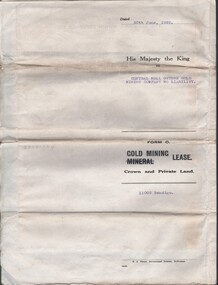
Document - MCCOLL, RANKIN AND STANISTREET COLLECTION: CENTRAL NELL GWYNNE, 30/11/39
Document. McColl, Rankin & Stanistreet, Central Nell Gwynne N/L. An indenture or lease on the 30/6/39 between King George V1 & the Central Nell Gwynne GMC N/L carrying on operations in the Parish of Sandhurst. No 11009 Bendigo. Entered in the Register book vol 324 fol. 35733McColl, Rankin & Stanistreetorganization, business, central nell gwynne, mccoll, rankin & stanistreet, central nell gwynne gmc, gold mining, indenture, lease -
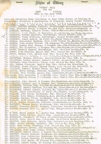 Otway Districts Historical Society
Voters, Shire of Otway, Shire of Otway, Voters' Rolls, 1963, 23 July 1963
After going to a Revision Court where the voters' rolls had been revised and certified correct every voter on the Shire of Otway register was listed with his or her surname, christian names, residence or post town, nature of calling or occupation, situation and description of property, the yearly value, and the number of votes to which the incumbent was entitled. It included both local residents and residents from other municipalities who owned allotments in the Shire of Otway entitled to vote in Shire of Otway elections.Typescript. Shire of Otway, Voters' Roll for the East (a), Central (b), West (c) and Apollo Bay [comprising a portion of the Parish of Krambruk] (d) Ridings, made in the year 1963. Certified for each riding that it "has been revised and is correct", signed by W.H. Tann, Chairman of Revision Court, 23rd July, 1963.Variously underlined, marked, and written on the verso.shire; otway; voter roll; -
Bendigo Historical Society Inc.
Map - CAMPBELL COLLECTION: PARISH MAPS
BHS CollectionNineteen Parish maps of Bendigo area in a plastic bag. Mostly original maps. Copies or originals of all maps are available to access in the Map Cupboard. Not catalogued separately. Maps come from Don Stewart, 10 Avery's Rd. Eaglehawk. Don now deceased. He worked in a Government job in bendigo. -
 Bendigo Historical Society Inc.
Document - LANDS OFFICE: SANDHURST AND DISTRICT LAND SALES 1865 - 1869, 1865 - 1869
Document: green hard cover journal with buff spine and corners. Contains details of land sales. Details on LH page: date, parish, section, allotment, area, applicant, val. asked. RH page: val. allowed owner of improvements., remarks. Dates range from 10th. January 1865 to 1869.Lands Officeland sales 1865 - 1869, sandhurst, bendigo, land sales, lands office. -
 Eltham District Historical Society Inc
Document - Survey Plan, Country Roads Board, SP 6559-6560, Eltham-Yarra Glen Road; Elsa Ct to Luck St, 1957
1957 C.R.B. Plan of Survey of Part of Crown Portion 13 Section 4 and Crown Allotment 1 Section 1 Parish of Nillumbik, County of Evelyn Eltham-Yarra Glen Road, Shire of Eltham Shows Surveyor field notes, property ownership and building type and construction.eltham-yarra glen road, country roads board, eltham, main road, survey plan, 1957, a.m. & a.a. iowerson, a.mcg. hepburn, cecil street, coffee lounge, diamond street, e.g. murrell, elsa court, h.b. woodhead, j.c. & s.i. harding, la ronde, luck street, r.m. & v.m. white, r.n. mowatt, the board of land & works, w.g. hains, neil webster collection -
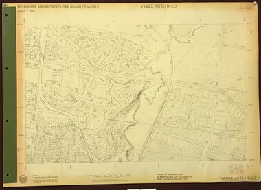 Greensborough Historical Society
Map, Melbourne and Metropolitan Board of Works. Survey Division, MMBW, Yarra 2500 / 15.22. Eltham North. Allendale Road, 1979_08
Melbourne and Metropolitan Board of Works. Yarra 2500 [base map] 15.22. Eltham North, Allendale Road. Parish of Nillumbik. Municipalities of Eltham 238 and Diamond Valley 257. Prominent streets include: Allendale Road, Godber Road and Ryans Road. Features include the Diamond Creek.MMBW Map in 1:2500 [scale] series. Cream parchment with green tape reinforcing on edges and punched holes on left edge.mmbw, melbourne and metropolitan board of works, shire of diamond valley, nillumbik, eltham - maps -
 Greensborough Historical Society
Advertisement - Digital image, Transfer of Land (William Duncan), 03/03/1877
Public advertisement on 3 March 1877 of application by William Duncan to bring a piece of land, part of Crown section 13, Parish of Nillumbik, County of Evelyn under the Transfer of Land Statute No. 9356. [This land is adjacent to St Helena Road, possibly near the Bonnie Doon Estate]Digital copy of public advertisement reproduced from TROVE 1 page.greensborough, william duncan -
 Uniting Church Archives - Synod of Victoria
Photograph, c.1980s
Ordained Presbyterian Minister 1963 in New Zealand. Dunedin parish 1963-1965, Professor Church History Knox College Dunedin 1965 to 1981, Professor Church History Theological Hall Melbourne 1982-12/1999. Retired 2000. Became UC Synod Archivist to 2015.B&W head and shoulders photograph of Rev. Dr Ian Breward.ian breward; presbyterian then uniting church minister; professor church history knox college and theological hall ormond college; synod archivist -
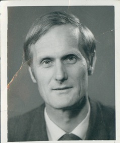
 Ballarat Diocesan Historical Commission
Photograph, Photograph of Fr J. McInerney
Image of Fr J. McInerney, former RAAF chaplain, Chaplain to CYMS and chaplain to Caroline Chisolm Migrant Hostel Creswick in the 1950s - 60s. Fr McInerney was long time parish priest at Creswick. He was made Monsignor later served as editor of the Ballarat Diocesan Journal "Light". -
 Greensborough Historical Society
Poster - Planning Document, Shire of Diamond Valley et al, Subdivision Plan # 1044 - Parish of Nillumbik, County Bourke, Crown Allotment B Section 12, Eltham North, 1981-1987
Subdivision Plan # 1044 - Parish of Nillumbik, County Bourke, Crown Allotment B Section 12, Eltham North. This subdivision plan includes Weidlich Road and St Clems Street. The developer for this subdivision is Taunton Developments and the Surveyors are Fisher Cleeland Turner & Dwyer Vic, Surveyors and Engineers.An example of hard copy subdivision plans from the Greensborough area. Mainly from the Shire of Diamond Valley era (1964-1994).Plan (single sided) mounted on heavy card. Stamped and handwritten Council permissions, dates and other details. subdivision plans, shire of diamond valley, taunton developments -
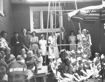 Ringwood and District Historical Society
Photograph, 1950 - Parish Hall Xmas Party, Church of England, Ringwood Street, Ringwood. Mrs. Caughey, Mrs. McCrae Senr. Mr. and Mrs. G. Williams, Mr. John McCrae, Mrs. M. McCall, Mrs. McWilliam, Mrs. Dedman, Mrs. Win Leslie, Director
Typed below photograph, "1950 - Parish Hall Xmas Party. Mrs. Caughey, Mrs. McCrae Senr. Mr. and Mrs. G. Williams, Mr. John McCrae, Mrs. M. McCall, Mrs. McWilliam, Mrs. Dedman, Mrs. Win Leslie, Director".