Showing 2355 items
matching park st
-
 St Kilda Historical Society
Photograph - Photo map, 08/02/1966
One of a series of photo-maps produced for the Department of Crown Lands and Survey (1857-1983). For correlation with a current map, and access to other historical photo maps of Victoria, see the Historic Photo-Maps Index published by the Department of Environment, Land, Water and Planning at https://services.land.vic.gov.au/DELWPmaps/historical-photomaps/Black and white aerial photographVic 1916 Melbourne 1966 Project Run 13 E 8.2.66 Lens 122 151.75MM 9.800 113st kilda, st kilda marina, st kilda beach, point ormond, elwood, elwood beach, elwood park, 1966 -
 St Kilda Historical Society
Photograph - Photo map, 08/02/1966
One of a series of photo-maps produced for the Department of Crown Lands and Survey (1857-1983). For correlation with a current map, and access to other historical photo maps of Victoria, see the Historic Photo-Maps Index published by the Department of Environment, Land, Water and Planning at https://services.land.vic.gov.au/DELWPmaps/historical-photomaps/Black and white aerial photographVic 1916 Melbourne 1966 Project Run 13 E 8.2.66 Lens 122 151.75MM 9.800 111st kilda, balaclava, caulfield, caulfield north, st kilda east, elsternwick, elsterwick park, elwood park, elwood canal, elwood beach, ripponlea, 1966 -
 St Kilda Historical Society
Photograph - Photo map, 11/01/1968
One of a series of photo-maps produced for the Department of Crown Lands and Survey (1857-1983). For correlation with a current map, and access to other historical photo maps of Victoria, see the Historic Photo-Maps Index published by the Department of Environment, Land, Water and Planning at https://services.land.vic.gov.au/DELWPmaps/historical-photomaps/Black and white aerial photographVic 2132 State Aerial Survey Melbourne 1968 Proj Run 27E 11.1.68 5100 ASL 65caulfield north, caulfield park, armadale, malvern, 1968 -
 St Kilda Historical Society
Photograph - Photo map, 11/01/1968
One of a series of photo-maps produced for the Department of Crown Lands and Survey (1857-1983). For correlation with a current map, and access to other historical photo maps of Victoria, see the Historic Photo-Maps Index published by the Department of Environment, Land, Water and Planning at https://services.land.vic.gov.au/DELWPmaps/historical-photomaps/Black and white aerial photographVic 2132 State Aerial Survey Melbourne 1968 Proj Run 27E 11.1.68 5100 ASL 67st kilda east, st kilda cemetery, caulfield north, alma park, balaclava, armadale, 1968 -
 St Kilda Historical Society
Photograph - Photo map, 13/01/1968
... ://services.land.vic.gov.au/DELWPmaps/historical-photomaps/ St Kilda West Albert Park ...One of a series of photo-maps produced for the Department of Crown Lands and Survey (1857-1983). For correlation with a current map, and access to other historical photo maps of Victoria, see the Historic Photo-Maps Index published by the Department of Environment, Land, Water and Planning at https://services.land.vic.gov.au/DELWPmaps/historical-photomaps/Black and white aerial photograph2138 State Aerial Survey Melbourne 1968 Proj. Run 26 13.1.68 5100 ASL 203st kilda west, albert park, fawkner park, south yarra, prahran, windsor, 1968 -
 St Kilda Historical Society
Photograph - Photo map, 11/01/1968
One of a series of photo-maps produced for the Department of Crown Lands and Survey (1857-1983). For correlation with a current map, and access to other historical photo maps of Victoria, see the Historic Photo-Maps Index published by the Department of Environment, Land, Water and Planning at https://services.land.vic.gov.au/DELWPmaps/historical-photomaps/Black and white aerial photographVic 2132 State Aerial Survey Melbourne 1968 Proj. Run 29E 11.1.68 5100 ASL 194elwood, elwood beach, elwood park, elsternwick park, ripponlea, elwood canal, balaclava, st kilda, 1968 -
 St Kilda Historical Society
Photograph - Photo map, 11/01/1968
... Kilda Pier Catani Gardens St Kilda Beach Albert Park 1968 Vic ...One of a series of photo-maps produced for the Department of Crown Lands and Survey (1857-1983). For correlation with a current map, and access to other historical photo maps of Victoria, see the Historic Photo-Maps Index published by the Department of Environment, Land, Water and Planning at https://services.land.vic.gov.au/DELWPmaps/historical-photomaps/Black and white aerial photographVic 2132 State Aerial Survey Melbourne 1968 Proj. Run 27E 11.1.68 5100 ASLst kilda, st kilda west, st kilda pier, catani gardens, st kilda beach, albert park, 1968 -
 St Kilda Historical Society
Photograph - Photo map, 11/01/1968
One of a series of photo-maps produced for the Department of Crown Lands and Survey (1857-1983). For correlation with a current map, and access to other historical photo maps of Victoria, see the Historic Photo-Maps Index published by the Department of Environment, Land, Water and Planning at https://services.land.vic.gov.au/DELWPmaps/historical-photomaps/Black and white aerial photographVic 2132 State Aerial Survey Melbourne 1968 Proj. Run 29E 11.1.68 5100 ASL 196elwood, elwood park, elwood canal, elwood beach, st kilda marina, mc moran reserve, point ormond, 1968 -
 St Kilda Historical Society
Photograph - Photo map, Department of Crown Lands and Survey (1857-1983), 22/01/1970
One of a series of photo-maps produced for the Department of Crown Lands and Survey (1857-1983). For correlation with a current map, and access to other historical photo maps of Victoria, see the Historic Photo-Maps Index published by the Department of Environment, Land, Water and Planning at https://services.land.vic.gov.au/DELWPmaps/historical-photomaps/Black and white aerial photographVic 2358 Department of Crown Lands and Survey Victoria,.© Melbourne 1970 Project Run 42E 22.1.70 5,100 ASL 77st kilda, st kilda east, st kilda marina, elwood, elwood canal, elsternwick park, point ormond, balaclava, mc moran reserve, ripponlea, st kilda botanical gardens, peanut farm, 1970 -
 St Kilda Historical Society
Photograph - Photo map, Department of Crown Lands and Survey, 22/01/1970
One of a series of photo-maps produced for the Department of Crown Lands and Survey (1857-1983). For correlation with a current map, and access to other historical photo maps of Victoria, see the Historic Photo-Maps Index published by the Department of Environment, Land, Water and Planning at https://services.land.vic.gov.au/DELWPmaps/historical-photomaps/Black and white aerial photographVic 2358 Department of Crown Lands and Survey Victoria,.© Melbourne 1970 Project Run 43E 22.1.70 5,100 ASL 208elwood, elwood beach, point ormond, elwood park, elwood canal, mc moran reserve, 1970 -
 St Kilda Historical Society
Photograph - Photo map, Department of Crown Lands and Survey, 22/01/1970
One of a series of photo-maps produced for the Department of Crown Lands and Survey (1857-1983). For correlation with a current map, and access to other historical photo maps of Victoria, see the Historic Photo-Maps Index published by the Department of Environment, Land, Water and Planning at https://services.land.vic.gov.au/DELWPmaps/historical-photomaps/Black and white aerial photographVic 2358 Department of Crown Lands and Survey Victoria,.© Melbourne 1970 Project Run 41E 22.1.70 5,100 ASL 64st kilda, st kilda cemetery, balaclava, st kilda east, windsor, caulfield north, alma park, 1970 -
 St Kilda Historical Society
Photograph - Photo map, 22/01/1970
One of a series of photo-maps produced for the Department of Crown Lands and Survey (1857-1983). For correlation with a current map, and access to other historical photo maps of Victoria, see the Historic Photo-Maps Index published by the Department of Environment, Land, Water and Planning at https://services.land.vic.gov.au/DELWPmaps/historical-photomaps/Black and white aerial photographVic 2358 Department of Crown Lands and Survey Victoria,.© Melbourne 1970 Project Run 43E 22.1.70 5,100 ASL 206elwood, elsternwick, elsternwick park, 1970 -
 St Kilda Historical Society
Photograph, Georgia Dimitroulis, 2009
Colour photograph, mountedI enjoy my school being in Ripponlea because lots of people are caring. Ripponlea has very pretty houses too. Ripponlea also has really green parks which are really good to play in. Ripponlea is a great community to be in because nobody gets left out. By Georgia Dimitroulisbusinesses, glen eira road, ripponlea, ripponlea state school -
 St Kilda Historical Society
Photograph, Tian Steuart
Photograph taken in 2009Colour photograph, mountedI took this photo because I think it represents Ripponlea. The photo shows all of the different things Ripponlea has to offer like beautiful parks with native plants and seating where you can see fascinating views. The station is a great part of Ripponlea because the station is old, interesting and it's good to travel from because it is never busy and it's always very clean. By Tian Steuartripponlea, ripponlea station, ripponlea state school -
 St Kilda Historical Society
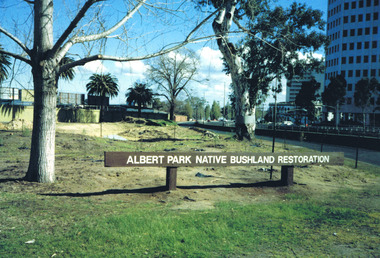
Photograph, Albert Park Native Bushland Restoration Project 1991 - images collection
The bushland area near the Corroborree Tree, near the corner of Fitzroy Street St Kilda and the Queens Road offramp from St Kilda Road, was restored in 1991 by Earthcare.Colour photographsst kilda junction, corroboree tree, albert park native bushland, 1991, earthcare, ngargee tree, james williams, albert park -
 St Kilda Historical Society
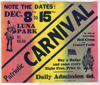
Ephemera - Poster, Patriotic Carnival, 1917
Advertising carnival to be held on 8-13th December at Luna Park to aid Australian Red Cross and Comfort FundsPaper, brightly coloured (orange, yellow, green) printed in blackvictorian red cross, luna park, australian comforts fund, wwi fund-raising -
 St Kilda Historical Society
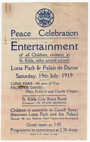
Ephemera - Flyer, Peace Celebration Entertainment, 1919
... for St Kilda children at Luna Park and the Palais de Danse, St ...Peace celebration entertainment for St Kilda children at Luna Park and the Palais de Danse, St KildaSingle sheet of white paper that has discoloured with age, printed in blueluna park, palais de danse, city of st kilda, wwi peace celebrations, st kilda brass band -
 St Kilda Historical Society
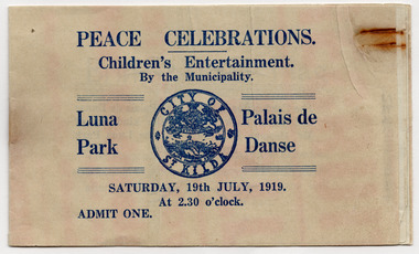
Ephemera - Booklet, Peace Celebrations, 1919
... on 19 July 1919. Luna Park Palias de Danse St Kilda Patriotic ...Contains tickets for rides at Luna Park and entry to the Palais de Danse to see a film starring Charlie Chaplin and Mary Pickford. The event was sponsored by the City of St Kilda for children as part of peace celebrations on 19 July 1919.Booklet of tickets printed in blue on white paper that has discoloured with age. City of St Kilda logo on the front. One ticket has been removed.luna park, palias de danse, st kilda patriotic committee, city of st kilda, wwi peace celebrations, children's entertainment -
 St Kilda Historical Society
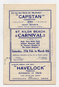
Ephemera - Program, St Kilda Beach Carnival 1926, 1926
Program of a 5-day festival held 27/2/1926 - 6/3/1926 to raise funds for the Bush Fire Relief Fund, Soldiers' Memorial Hall, St Vincent's Hospital and the Catani Memorial (St Kilda cenotaph). The carnival began with a procession from what is now St Kilda Junction, down Fitzroy Street to Luna Park and the Lower Esplanade. Events included novelty races and contests including pillow-fighting, a paddling race where contestants had to balance on kerosene tins, a cigarette race where competitors raced with lighted cigarettes, and many other contests at the beach. There were also swimming events, boat races, lifesaving demonstrations, displays, music and dancing. The program contains extensive advertising from local businesses.Booklet made of 5 sheets of white paper, discoloured with age, folded, stapled and printed in blue and blackst kilda carnivals, wwi fund-raising, st kilda memorial hall, st kilda cenotaph, st kilda beach -
 St Kilda Historical Society
Ephemera - Ticket, Picnic to Park Orchards, 1936
Ticket to picnic at Park Orchards on 21 December 1936, organised by the St Kilda Unemployed Organisation with the support of the St Kilda City Council, Mayor (Cr Alfred Levy), Archie Michaelis MLA, and 'other well-known gentlemen'. The ticket appears to have been perforated to allow vouchers, printed on the back (for bus, dinner, toys, stockings, ice cream and tea) to be separated and used. Park Orchards is a residential suburb 23km north east of Melbourne that was created in 1925 on land used for orchards when timber merchants Australis Sharp and John Taylor launched the Park Orchards Country Club estate. Buyers were not attracted to the estate, and for many years all that existed were a clubhouse and various sporting facilities. It gained popularity when demand for housing surged in the 1950s.Grey/green coloured card, printed in blue on both sides and with 5 evenly spaced lines of perforations across the width.st kilda unemployed organisation, st kilda council -
 St Kilda Historical Society
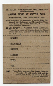
Ephemera - Ticket, Annual Picnic at Wattle Park, 1938
Ticket to picnic at Wattle Park on 14 December 1938, organised by the St Kilda Unemployed Organisation with the support of the St Kilda City Council, The Melbourne and Metropolitan Tramway Board, Archie Michaelis MLA, and 'other generous supporters'. The ticket is also a tram ticket to Wattle Park and back and appears to have been perforated to make detachable vouchers for dinner, ice-cream, drinks, lollies, toys and tea.Brown coloured card printed in black on one side, with 7 perforated lines across the width.st kilda unemployed organisation, st kilda council -
 St Kilda Historical Society
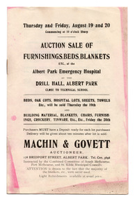
Ephemera - Catalogue, Auction Sale of Furnishings, Beds, Blankets etc of the Albert Park Emergency Hospital, 1920
Catalogue for the auction of items of the Albert Park Emergency Hospital at the Drill Hall, 178 Bridport Street, Albert Park, under instruction of a combined committee of the South Melbourne, Port Melbourne and St Kilda Councils. The full date is not given. During the Spanish Flu epidemic in 1919, 34 emergency hospitals were created in Victoria because the existing hospitals were unable to cope with the demand for care. An Epidemic Hospital was set up in the Drill Room at Albert Park, the expenses shared between the South Melbourne, Port Melbourne and St. Kilda Councils, to serve influenza patients from those local government areas. Each Council had three representatives on the Board of Management. Like the other emergency hospitals, the Albert Park hospital operated only for a short time while the epidemic was at its height. As noted in the catalogue, 'the majority of the blankets, etc. were never used.' It is possible that items advertised in this catalogue were auctioned on Thursday 19 August and Friday 20 August 1920. The items for sale include hospital equipment, furniture, sheets, pillows, towels, building materials, blankets, crockery, cutlery, clothing, furnishings.Document of 3 sheets of white paper (discoloured with age), folded and stapled and printed in blackalbert park emergency hospital, spanish flu, spanish influenza -
 St Kilda Historical Society
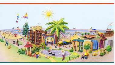
Postcard, Raymond Besserdon original design, Published by the City of Port Phillip
postcard coloured. Graphic representation of Luna Park and environs.Port Phillip Alive! -
 St Kilda Historical Society
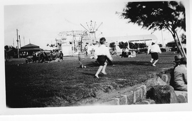
Photograph, St Kilda Pier Gardens
... Carlisle Street St Kilda melbourne Luna Park in the background ...Luna Park in the background, c1920black and white photograph, unmountedSt Kild Pier Gardens showing Luna Park -
 St Kilda Historical Society
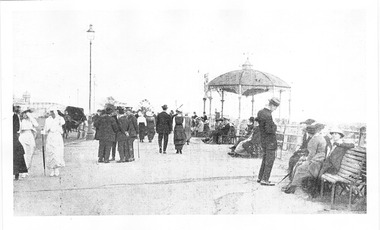
Photograph, Esplanade Bandstand, c.1915
Showing Bandstand (erected 1895 c) Luna Park in background . Foreground people promenadingblack and white photograph, unmountedEsplanade -
 St Kilda Historical Society
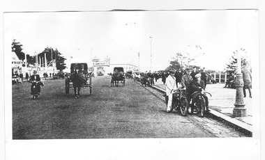
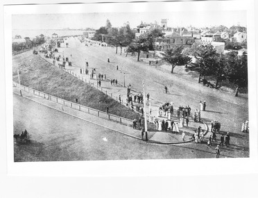
Photograph, Upper Esplanade, St Kilda, c. 1914
... Melbourne -Suburbs St Kilda Upper Esplanade with Luna Park... towards Luna Park, c1914 Melbourne -Suburbs St Kilda Upper ...Paradise Pictures, looking towards Luna Park, c1914black and white photograph, unmounted copy, good conditionMelbourne -Suburbs St Kilda Upper Esplanade with Luna Park in the Distance. St Kilda by the Sea Annual Season 1915/16 p.16 F600:65 c1890 -
 St Kilda Historical Society
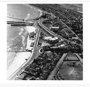
Photograph - Aerial, St Kilda
showing Luna Park, the Palace Theatre, the Palais and St Moritzblack and white photograph, unmounted original, good conditionNeg 27 -
 St Kilda Historical Society
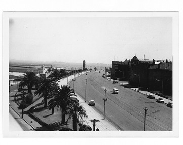
Photograph, Esplanade St Kilda
View from Luna Park looking west, cars on Upper Esplanadeblack and white photograph , unmounted fair conditionWritten by hand: donated by Julia Murray of Friends of St Kilda on 8.9.2005, The Espanade St Kilda -
 St Kilda Historical Society
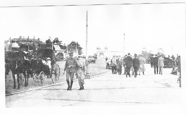
Photograph, Upper Esplanade St Kilda, c. 1914
c1914 people promenading on Upper Esplanade. Man in military uniform, horse drawn carriage and motor cars, Luna Park in background black and white photograph, unmounted, copy, fair conditionMelbourne Suburbs St Kilda -
 St Kilda Historical Society
Photograph, Esplanade St Kilda
... Melbourne Suburbs St Kilda View of Esplanade St Kilda from... Carlisle Street St Kilda melbourne view from Luna Park tower ...view from Luna Park tower black and white photograph, unmounted, good conditionMelbourne Suburbs St Kilda View of Esplanade St Kilda from Luna Park Tower, stamped National Library of Australia