Showing 11126 items
matching planning.
-
 Federation University Historical Collection
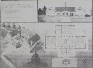
Plan (copy), 'Proposed New Catholic School at Camperdown' by Herbert L. Coburn
Ballarat born Herbert L. Coburn grew up to be a renowned Ballarat architect, practising from 1905 to 1956. He taught Architecture and Building Construction at the Ballarat School of Mines (SMB) from 1918, resigning in 1948 due to ill health. Copy of a plan for a Catholic primary school at Camperdown by H.L. Coburn. The plan includes front elevation, ground floor and block plan.coburn, h.l. coburn, herbert l. coburn, architecture, camperdown, architectural plan -
 Port Melbourne Historical & Preservation Society
Document - Specification, Pool Street from Nott Street to Princes Street, Engineering Department, Town of Port Melbourne, 14 Mar 1893
Plan for Pool Street from Nott Street to Princes Street Loan Works 1893 plan 18; relates to plan 97.2Signed by JJ Bartlett (Mayor) 14.3.1893engineering - roads streets lanes and footpaths, town planning, town clerks, mayors, arthur victor heath, james john bartlett -
Whitehorse Historical Society Inc.
Legal record - Illustration, Display Centre. Nunawading Historical Society
Architect's outing plans of museum for Schwerkolt's Cottage.Architect's outing plans of museum for Schwerkolt's Cottage. Gives concept drawings, elevations and plan. Differs in detail from final plan.Architect's outing plans of museum for Schwerkolt's Cottage. schwerkolt cottage & museum complex, architects plans -
 Bendigo Historical Society Inc.
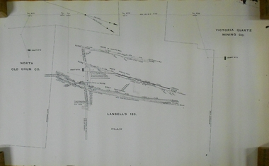
Document - MARKS COLLECTION: LANSELL'S 180 PLAN
Plan (copy) of Lansell's 180 mine shaft. Plan LH side is marked with North Old Chum Co. Shaft No. 78, in centre detailed plan of Lansell's 180 shaft, and marked on LH side of plan Victoria Quartz Co., (no detailed plan).bendigo, mining, lansell's 180 mine -
 Bendigo Historical Society Inc.
Document - MARKS COLLECTION: PLAN PRINCIPAL ENTRANCE FORTUNA VILLA AND GARDEN FRONT
2 copies of plans. 1. Smaller plan; written on plan Principal Entrance Front Fortuna Villa Sandhurst, G. Lansell Esq, Proprietor. Plan shows front entrance elevation, also floor plan of vestibule and verandah. 2. Large plan: written on plan Garden front, Fortuna Villa Sandhurst, G. Lansell, Esq. Proprietor dated July 3rd. 1871. buildings, house, fortuna villa -
 Federation University Historical Collection
Plan, Ballarat School of Mines Building Development, 11/04/1964
With the development of tertiary education in the 1960s and 1970s the Ballarat School of Mines asked Coburn and Associates to design new buildings for the Ballarat School of Mines site, utilising the Ballarat Gaol site. The plans did not proceed, with the Mount Helen Campus being created instead. For information on Herbert L. Coburn go to http://guerin.ballarat.edu.au/curator/honour-roll/honourroll_Coburn,%20H.L.shtmlThree copies of plans by Coburn and Associates, with hand applied colour. The plans relate to a proposed development of the Ballarat School of Mines. .1) - shows the Ballarat School of Mines site, with proposed new buildings. It also shows buildings along Dana Street including the Ballarat Club, as well as White Flat. .2) View of proposed Library and Union Building .3) View of proposed Engineering Buildinguniversity of ballarat, ballarat school of mines, architect, herbert coburn, herbert l coburn, coburn and associates, architectural plans -
 Lakes Entrance Historical Society
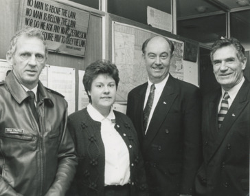
Photograph - plans for new Police Station Lakes Entrance Victoria, Lakes Post Newspaper, 1/07/1996 12:00:00 AM
announcement of plans for new Police Station L to R Inspector Alan Chaffey, Jacqueline Lalor, David Treasure MP, Bill McGrath Minister for Police and Corrective Services Lakes Entrance VictoriaBlack and white photograph at announcement of plans for new Police Station L to R Inspector Alan Chaffey, Jacqueline Lalor, David Treasure MP, Bill McGrath Minister for Police and Corrective Services Lakes Entrance Victoriapolice, community facilities, law and order -
 Bendigo Historical Society Inc.
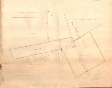
Document - MARKS COLLECTION: HOBSON AND LANSELL PLANS SHOWING LAND IN DISPUTE
Plan, hand drawn, showing Hobson and Lansell plan 'shewing ground in dispute' On plan East Johnson Lease Ground, Hobson and Lansell land in between, West of England company on bottom of plan.bendigo, mining, hobson and lansell -
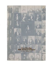 City of Greater Bendigo - Civic Collection
Financial record - Mayoral Report, City of Bendigo, 1990
Financial and civic report.A4 size Mayoral report including Councillor and Executive officer information, organisational structure, economic development, planning, family and leisure services. No mention of arts or cultural services. non-fictionFinancial and civic report.mayor morley, mayoress morley, councillor p. r. morley -
 Kew Historical Society Inc
Plan - Subdivision Plan, J Hurrey, Section 115 in the Parish of Boroondara Near Richmond Bridge, 1853
Despite the plans claims that it is a subdivision near the Richmond Bridge, Section 115 was located at what is now Camberwell Junction. While the plan only lists government roads rather than named streets, the section was located on the east side of Burke Road, stretching up the hill from the current Junction. Research on Trove, conducted by Kerry Fairbank, discovered an advertisement for unsold lots in Section 115 which clarifies the extent and location of subsequent land sales in the original section. The original article can be viewed through the link in the catalogue record. The interesting link to Kew is the reference to James Beavan as the purchaser of lots 14 and 15. The historian Gwen McWilliam has notes that a Mr Beavan changed his name from Bevan. The Bevans were descendants of the Derricks family of Kew. This subdivision plan is the earliest original map or plan in the collection which shows parts of what is now the City of Boroondara, dating from circa 1853. It provides important information for researchers on subsequent subdivisions following the original land sales in [Camberwell] Boroondara. The site, on the east side of Burke Road is a highly-significant and historic site. This is believed to be the only extant copy of the subdivision in public collections.A small plan on parchment listing 28 lots, between one and two acres each, for sale in Section 115 in the Parish of Boroondara, dating from 1853 when the portion was subdivided.Obverse: Lot 16 "Joseph Duval", Lots 14 & 15 "James Beavan". Other annotations (measurements) are unreadable. Reverse: "KH-981 / Section 115 in the Parish of Boroondara / Near Richmond Bridge / 1640T. / J Duval / 14-15 J. Beavanparish of boroondara, subdivision plans - camberwell, section 115 - boroondara, subdivision plans -- camberwell (vic), riverscape road, burke road, camberwell junction -
 Kew Historical Society Inc
Plan - Subdivision Plan, Belford Heights Estate, Kew, ca. 1925
Pru Sanderson, in her groundbreaking ‘City of Kew Urban Conservation Study : Volume 2 - Development History’ (1988), summarised the periods of urban development and subdivisions of land in Kew. The periods that she identified included 1845-1880, 1880-1893, 1893-1921, 1921-1933, 1933-1943, and Post-War Development. These periods were selected as they represented periods of rapid growth or decline in urban development. An obvious starting point for Sanderson’s groupings involved population growth and the associated economic cycles. These cycles also highlighted urban expansion onto land that was predominantly rural, although in other cases it represented the decline and breakup of large estates. A number of the plans in the Kew Historical Society’s collection can also be found in other collections, such as those of the State Library of Victoria and the Boroondara Library Service. A number are however unique to the collection.The Kew Historical Society collection includes almost 100 subdivision plans pertaining to suburbs of the City of Melbourne. Most of these are of Kew, Kew East or Studley Park, although a smaller number are plans of Camberwell, Deepdene, Balwyn and Hawthorn. It is believed that the majority of the plans were gifted to the Society by persons connected with the real estate firm - J. R. Mathers and McMillan, 136 Cotham Road, Kew. The Plans in the collection are rarely in pristine form, being working plans on which the agent would write notes and record lots sold and the prices of these. The subdivision plans are historically significant examples of the growth of urban Melbourne from the beginning of the 20th Century up until the 1980s. A number of the plans are double-sided and often include a photograph on the reverse. A number of the latter are by noted photographers such as J.E. Barnes.The Belford Heights Estate was a subdivision in Kew East, even though the title of the plan indicates that it was located in Kew. The subdivision had been approved by 1915, and included 105 lots facing Strathalbyn, Kitchener, Hamilton and Beresford Streets, as well as Balfour and Belford Roads. Those lots hand coloured with red probably represent blocks that had been sold. The additional information provided on the plan is also of interest. The plan includes the original location of East Kew State (Primary) School in Strathalbyn Street, which opened in 1892. The inset Locality Plan also includes the route of the Outer Circle Railway and the location of the Wilsmere and East Kew Stations. The location of the landmark Harp of Erin Hotel is also marked on the Locality Plan.belford heights estate, subdivision plans - kew -
 Kew Historical Society Inc
Plan - Subdivision Plan, Shop Sites, East Kew, c.1927
Subdivision plans are historically important documents used as evidence of the growth of suburbs in Australia. They frequently provide information about when the land was sold on which a built structure was subsequently constructed as well as evidence relating to surveyors and real estate and financial agents. The numerous subdivision plans in the Kew Historical Society's collection represent working documents, ranging from the initial sketches made in planning a subdivision to printed plans on which auctioneers or agents listed the prices for which individual lots were sold. In a number of cases, the reverse of a subdivision plan in the collection includes a photograph of a house that was also for sale by the agent. These photographs provide significant heritage information relating house design and decoration, fencing and household gardens.This is one of a small number of subdivision plans for commercial property in the collection. The subdivision proposed to create six shop sites in High Street between the Harp of Erin and Station Street. The plan shows this stretch of High Street, East Kew already lined with shops that include the hotel on the corner, the new State Savings Bank, a dentist’s surgery and Lambert’s Store. The High Street Tram was to reach Burke Road in 1925, so the proposed subdivision must postdate that event, and the opening of the Bank in 1926.subdivision plans - east kew, high street - east kew -
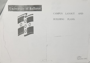 Federation University Historical Collection
Plan, University of Ballarat Campus Layout and Building Plans September 1995
University of Ballarat is a predecessor of Federation UniversityA3 pages with plans of University of Ballarat Campus layout and building plans With Compliments Slip from Prof. P. Candybuilding plans, university of ballarat, campus layout, prof. p candy, with compliments -
 Federation University Historical Collection
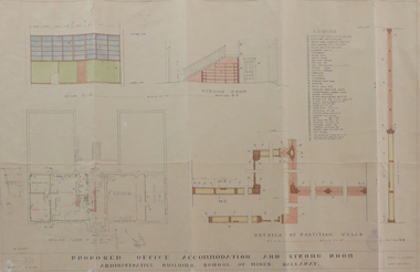
Plan, Ballarat School of Mines Administration Building Proposed Office Accomodation and Strong Room Plan, 1951, 12/06/1951
Plan of Ballarat School of Mines Administration Building plan with coloured shadingballarat school of mines, administration building, new classrooms, percy e. everett -
Port Melbourne Historical & Preservation Society
Plan - Council Chambers, Borough of Sandridge, Borough of Sandridge, Mar 1861
1861 Plan for the Borough Council Chambers, Sandridge, showing "elevation" and "plan"."Frederick William Bull, Municipal Surveyor" (Sandridge March 28th, 1861)local government - borough of sandridge, built environment - civic, frederick william bull -
University of Melbourne, Burnley Campus Archives
Document, Garden Week, 1986-1991
Notes for planning Garden Week, attendance figures, site plan, etc.garden week, attendance -
 RMIT Design Archives
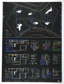
Architectural drawings, Plans and details for the Group Housing Project, Ivanhoe
Includes site plan; floor plans and details of utilities, interior and fittings.architecture, domestic architecture -
 University of Melbourne, Burnley Campus Archives
Plan, VCAH -Burnley: Sluice Valve, Tap & Fire Hydrant Locations, c. 1987
Plan showing locations and instructions for use, hand drawn. "Overlay onto SP1 Plan 1/1987," handwritten on it. Plan same as 11.0715.vcah, sluice valves, taps, fire hydrants -
 Federation University Historical Collection
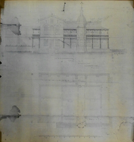
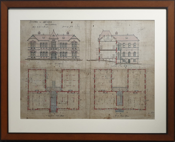
Plan, Architectural Plan for the Ballarat School of Mines New Classrooms, 1899
Framed original plan of the Ballarat School of Mines New Classrooms (later called the Administration Building). The plan includes a front elevation, a gound floor plan, first floor ground plan, and a section on line. ballarat school of mines, architectural plan, administration building, new classrooms -
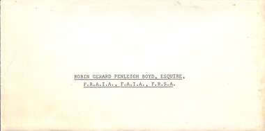 Robin Boyd Foundation
Award, Commonwealth of Australia, Honours and Awards, 1971
This is the citation appointing Robin Gerard Penleigh Boyd, Esquire F.R.A.I.A., F.A.I.A., F.R.S.A. a Commander of the Civil Division of the Most Excellent Order of the British Empire. The citation states "Member, National Capital Planning Committee. For services to Architecture and Government".Citation on Governor General Commonwealth of Australia letterhead in envelope.Honours and Awards 12 June, 1971. Appointed a Commander of the Civil Division of the Most Excellent Order of the British Empire Robin Gerard Penleigh Boyd, Esquire F.R.A.I.A., F.A.I.A., F.R.S.A. Member, National Capital Planning Committee. For services to architecture and Government. -
Port Melbourne Historical & Preservation Society
Plan - Port Melbourne Yacht Club, John Adam, Architect, 1960s
Plans for Port Melbourne Yacht Club new dinghy building 1962. .01 Storage layouts - sketch plan .02 Plan of new dinghy building .03 Location and pile plan .04 Working drawing - site elevations .05 Working drawing - plan view sport - yachting, built environment - recreational facilities -
Whitehorse Historical Society Inc.
Article, Two cities to go into the blender, 1994
After a year's speculation the Local Government Board has recommended in its interim report that the two municipalities be merged to form the new City of Koornung.After a year's speculation the Local Government Board has recommended in its interim report that the two municipalities be merged to form the new City of Koornung. Most of the amalgamation will be undertaken by Commissioners (to be appointed by the State Government) Nunawading City Manager, Warwick Dilley, believes to develop a corporate plan.After a year's speculation the Local Government Board has recommended in its interim report that the two municipalities be merged to form the new City of Koornung.local government, victoria. local government board, city of nunawading, city of box hill, dilley, warwick, port, ian, amalgamations -
 City of Kingston
Pamphlet - Colour, Arthur Tuckett & Son, Auctioneers and Subdivisional Specialists, Auction of Station Estate, Moorabbin, 1923
Sales plan for land in the suburb of Moorabbin, bounded by Railway Crescent, South Road, Jasper Road and Pattersons Road.The developing urban area of Moorabbin within the City of Kingston. This land sale pamphlet illustrates the subdivision of land within the municipality and the changing demographic of the district as new houses are constructed.Colour pamphlet advertising an auction of the Station Estate Moorabbin. Incorporates details of the shopping facilities, proximity to the railway line, variety of schools and churches in the area, and a sales plan for home sites and shop fronts. Incorporates a map of the estate bordered by Pattersons Road, Japer Road, South Road and Railway Crescent. Handwritten in grey pencil top right front page: Station Estate / late [indecipherable] Handwritten in red pencil on subdivision map: x [on majority of properties marked on the map] Handwritten in grey pencil on subdivision map: additional subdivisions drawn in and large lines drawn across the mapmoorabbin, land sales, estate -
 Mission to Seafarers Victoria
Poster, Ying-Lan Dann, Circular Temporalities, July 2022
Take Hold of the Clouds is a curated exhibition featuring two key works by renowned international contributors – Forensic Architecture’s Cloud Studies (2021) and Cauleen Smith’s Sojourner (2018) – along with six, newly commissioned, responsive works from local and national creative practitioners. The experimental exhibition is distributed across seven of the city’s most significant buildings and urban spaces, with each temporal creative work adding a new layer to how we understand these spaces in relation to the world around us. Embedding the work within the city itself rather than a traditional gallery, the exhibition models best practices for high-impact yet sustainable and resource-sensitive exhibition-making. Created in partnership with Monash University, Take Hold of the Clouds navigates the Weekend’s theme of Built/Unbuilt through a series of thoughtful encounters in which artists reveal the invisible stories and issues in corners of the city. The exhibition is conceived by Tara McDowell, Director of Curatorial Practice at Monash Art, Design and Architecture, and co-curated with Fleur Watson, Open House Melbourne’s Executive Director. To create this poster, the artist used a copy of of one of Walter Butler plans for the 7171 building held in the archives as an homage to the architect. The sketch was then retouched to make it loo like a blueprint. The Mission is one of the sites open every year during Open House. A3 size Blue print type plan print on glose paper.open house melbourne, 2022, ying-lan dann, circular temporalities, norla dome, blueprint, plans, walter richmond butler (1864–1949), cultural events -
 Ringwood and District Historical Society
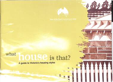
Book, What house is that?, 2007
A guide to Victoria's housing styles and eras (first and second editions)First edition - 2004, The Year of the Built Environment. Foreword by Mary Delahunty, MP, Minister for Planning. Second edition, Foreword by Hon. Justin Madden, MLC, Minister for Planning. -
 Bendigo Historical Society Inc.
Document - MARKS COLLECTION: STRATHFIELDSAYE PLAN 1854
Plan drawn on light paper. Written on LH side of plan 'Plan of Part of the Parish of Strathfieldsaye 1854. Scale (shown) Lithographed at the Surveyor Generals Office, Melbourne July 10th. By I. Jones'. Plan shows Emu Creek and Village Reserve at top of plan, Shepherd's Creek on RH side, Parish Boundary Line on RH and bottom of plan.map, bendigo, shire of strathfieldsaye 1854 -
Whitehorse Historical Society Inc.
Map, Plan of the Parish of Nunawading, 1853
Photocopy of map showing names of selectors, also list of references to the corners of allotments.Photocopy of map showing names of selectors, also list of references to the corners of allotments. Note on verso:'Gardiners Creek, Ballyshanassey township surveyed by H. Parmein, Surveyor General's Office Nov 30, 1853 also Reference to the Corners of allotments' (Plan 428)Photocopy of map showing names of selectors, also list of references to the corners of allotments. land subdivision, gardiners creek, ballyshanassy, parmein, h, burwood east, maps -
University of Melbourne, Burnley Campus Archives
Plan, Ian Robertson, Student Gardens Burnley Campus, 1989
Plans on tracing paper by Ian Robertson. Scale 1:50. 1. Planting Plan, Sheet No 5, 19.5.89. 2. Master Plan, Sheet No 6, 6.6.89. 3. Preliminary Plan Sheet No 4, 19.5.89.ian robertson, burnley campus, student gardens -
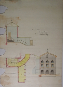 Bendigo Historical Society Inc.
Plan - MARKS COLLECTION: PLAN FOR ADDITIONS TO FORTUNA VILLA FOR GEO. LANSELL ESQ. - STAIRCASE ADDITION
Fortuna Villa was owned from 1855 to 1871 by Christopher and Theodore Ballerstedt, Australia’s first mining magnates. In 1871 it was purchased by George Lansell (The Quartz King) being one of Australia’s most successful and adventurous nineteenth century gold mine owners and speculators. Lansell made numerous alterations extensions to the building and remained in the Lansell family until 1935Plan for the addition and necessary modifications of a staircase to Fortuna Villa, the residence of George Lansell Esq. Coloured plan Plan is damaged missing several sections on the LHS of the plan and has water damage in lower LH cornerfortuna villa, lansell, stair case -
Port Melbourne Historical & Preservation Society
Plan - Proposed extensions, Heath Street, Port Melbourne Town Hall, E J Pembroke, 15 Oct 1936
Floor plans, elevations to Heath street; south end; roof plan for proposed extensions to supper room Town Hall 1936. Coloured plans."City of Port Melbourne . Proposed Extensions to Supper Room . Town Hall"port melbourne town hall, pembroke and turner, e j pembroke