Showing 16996 items
matching plenty-river
-
 Eltham District Historical Society Inc
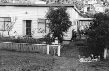
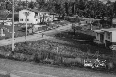
Photograph, 54 Alma Street, Lower Plenty, c.July 1967, 1967
Packaged in "Filmpro King Size prints Definitely Better EST. 1918" envelope. Pencil notes: 36 shots $2.87 Eltham Shire J. McD and 19/7/67. Alma Street and Kett Street Lower Plenty c.July 1967.Black and white photographalma street, lower plenty, houses, streets -
 Eltham District Historical Society Inc
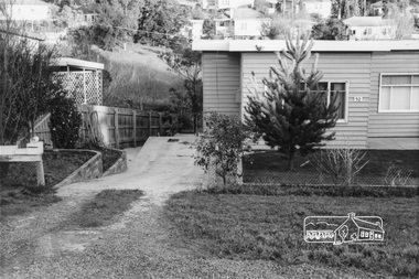
Photograph, 52 Alma Street, Lower Plenty, c.July 1967, 1967
Packaged in "Filmpro King Size prints Definitely Better EST. 1918" envelope. Pencil notes: 36 shots $2.87 Eltham Shire J. McD and 19/7/67. Alma Street and Kett Street Lower Plenty c.July 1967.Black and white photographalma street, lower plenty, houses, streets -
 Eltham District Historical Society Inc
Photograph, 53 Alma Street, Lower Plenty, c.July 1967, 1967
Packaged in "Filmpro King Size prints Definitely Better EST. 1918" envelope. Pencil notes: 36 shots $2.87 Eltham Shire J. McD and 19/7/67. Alma Street and Kett Street Lower Plenty c.July 1967.Black and white photographalma street, lower plenty, houses, streets -
 Eltham District Historical Society Inc
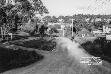
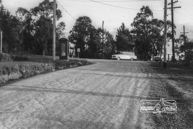
Photograph, Intersection of Kett Street (dirt road) with Airlie Road, Lower Plenty, c. July 1967, 1967
Packaged in "Filmpro King Size prints Definitely Better EST. 1918" envelope. Pencil notes: 36 shots $2.87 Eltham Shire J. McD and 19/7/67. Alma Street and Kett Street Lower Plenty c.July 1967.Black and white photographlower plenty, houses, streets, airlie road, kett street -
 Eltham District Historical Society Inc
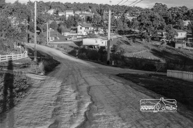
Photograph, Looking southeast along Kett Street towards intersection with Alma Street, Lower Plenty, c.July 1967, 1967
Packaged in "Filmpro King Size prints Definitely Better EST. 1918" envelope. Pencil notes: 36 shots $2.87 Eltham Shire J. McD and 19/7/67. Alma Street and Kett Street Lower Plenty c.July 1967.Black and white photographlower plenty, houses, streets, kett street, alma street -
 Eltham District Historical Society Inc
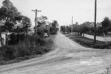
Photograph, Looking west along Alma Street from Kett Street, Lower Plenty, c.July 1967, 1967
Packaged in "Filmpro King Size prints Definitely Better EST. 1918" envelope. Pencil notes: 36 shots $2.87 Eltham Shire J. McD and 19/7/67. Alma Street and Kett Street Lower Plenty c.July 1967.Black and white photographlower plenty, houses, streets, kett street, alma street -
 Eltham District Historical Society Inc
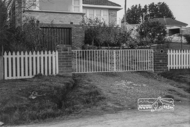
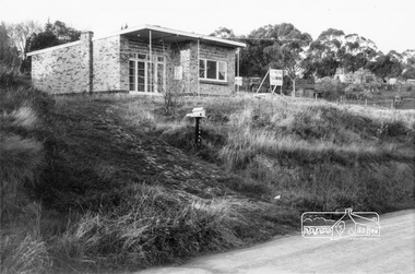
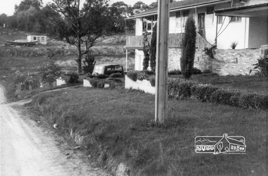
Photograph, Bramall house, 8 Kett Street, Lower Plenty, c.July 1967, 1967
Packaged in "Filmpro King Size prints Definitely Better EST. 1918" envelope. Pencil notes: 36 shots $2.87 Eltham Shire J. McD and 19/7/67. Alma Street and Kett Street Lower Plenty c.July 1967.Black and white photographlower plenty, houses, streets, kett street, bramall -
 Eltham District Historical Society Inc
Photograph, Looking towards the intersection of Kett Street with Main Road from 8 Kett Street, Lower Plenty, c.July 1967, 1967
Packaged in "Filmpro King Size prints Definitely Better EST. 1918" envelope. Pencil notes: 36 shots $2.87 Eltham Shire J. McD and 19/7/67. Alma Street and Kett Street Lower Plenty c.July 1967.Black and white photographlower plenty, houses, streets, kett street, main road -
 Eltham District Historical Society Inc
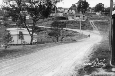
Photograph, Looking south along Kett Street to intersection with Main Road, Lower Plenty, c.July 1967, 1967
Packaged in "Filmpro King Size prints Definitely Better EST. 1918" envelope. Pencil notes: 36 shots $2.87 Eltham Shire J. McD and 19/7/67. Alma Street and Kett Street Lower Plenty c.July 1967.Black and white photographlower plenty, houses, streets, kett street, main road -
 Eltham District Historical Society Inc
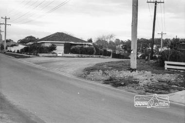
Photograph, 175 Main Road, cnr of Kett Street, Lower Plenty, c.July 1967, 1967
Packaged in "Filmpro King Size prints Definitely Better EST. 1918" envelope. Pencil notes: 36 shots $2.87 Eltham Shire J. McD and 19/7/67. Alma Street and Kett Street Lower Plenty c.July 1967.Black and white photographlower plenty, houses, streets, kett street -
 Eltham District Historical Society Inc
Photograph, Looking north along Kett Street from near the intersection with Main Road, Lower Plenty, c.July 1967, 1967
Packaged in "Filmpro King Size prints Definitely Better EST. 1918" envelope. Pencil notes: 36 shots $2.87 Eltham Shire J. McD and 19/7/67. Alma Street and Kett Street Lower Plenty c.July 1967.Black and white photographlower plenty, houses, streets, kett street, main road -
 Eltham District Historical Society Inc
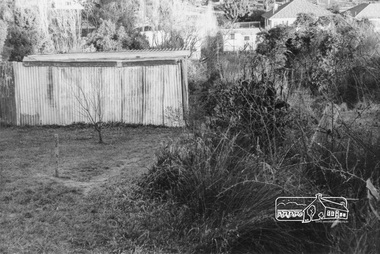
Photograph, Possibly at the end of Maskell Crescent, Lower Plenty, c.July 1967, 1967
Packaged in "Filmpro King Size prints Definitely Better EST. 1918" envelope. Pencil notes: 36 shots $2.87 Eltham Shire J. McD and 19/7/67. Alma Street and Kett Street Lower Plenty c.July 1967.Black and white photographlower plenty, houses, streets, maskell crescent -
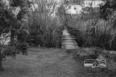 Eltham District Historical Society Inc
Photograph, Possibly at the end of Maskell Crescent, Lower Plenty, c.July 1967, 1967
Packaged in "Filmpro King Size prints Definitely Better EST. 1918" envelope. Pencil notes: 36 shots $2.87 Eltham Shire J. McD and 19/7/67. Alma Street and Kett Street Lower Plenty c.July 1967.Black and white photographlower plenty, houses, streets, maskell crescent -
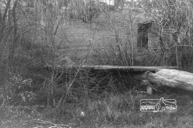 Eltham District Historical Society Inc
Photograph, Possibly at the end of Maskell Crescent, Lower Plenty, c.July 1967, 1967
Packaged in "Filmpro King Size prints Definitely Better EST. 1918" envelope. Pencil notes: 36 shots $2.87 Eltham Shire J. McD and 19/7/67. Alma Street and Kett Street Lower Plenty c.July 1967.Black and white photographlower plenty, houses, streets, maskell crescent -
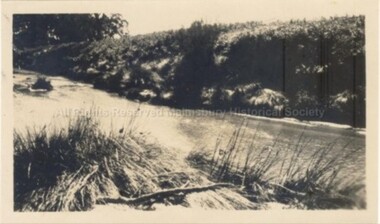
 Malmsbury Historical Society
Photograph (Item), "B/W Coliban River, Malmsbury", Malmsbury c1934
Buildings - Coliban River -
 Malmsbury Historical Society
Photograph (Item), View Of Coliban(?) River (Near Ellis Falls?) At Malmsbury, Malmsbury c1920
Buildings - River (Coliban/?) -
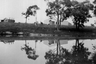 Greensborough Historical Society
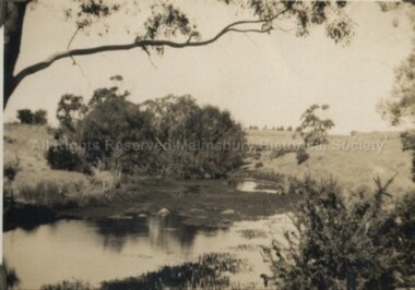
Photograph - Digital image, John McLaughlin's Plenty, 1933, 1933_
Part of a collection of photographs owned by Dorris McLaughlin who was born in Greensborough, in 1899 to John McLaughlin and Rosalie Ellen Whatmough. The collection contains photographs of friends and relatives from the Greensborough and Eltham areas. This photograph shows farm buildings at Plenty reflected in water.Digital copy of black and white photograph.dorris mclaughlin, john mclaughlin, plenty -
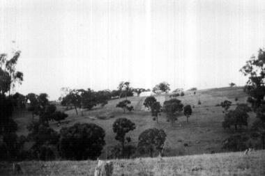 Greensborough Historical Society
Photograph - Digital image, John McLaughlin's Paddock, Plenty, 1934, 1933_
Part of a collection of photographs owned by Dorris McLaughlin who was born in Greensborough; in 1899 to John McLaughlin and Rosalie Ellen Whatmough. The collection contains photographs of friends and relatives from the Greensborough and Eltham areas. This photograph shows part of John McLaughlin's Plenty property.Digital copy of black and white photograph.dorris mclaughlin, john mclaughlin, plenty -
 Orbost & District Historical Society
black and white photographs, Howard D. Bulmer, first half 20th century
This bridge was built in the 1920s as a road and rail bridge, and was partly washed away by flood waters in 1934. After the end of the first World War the Victorian Railways considered an extension of the railhead across the river at Orbost, and in 1922 a new timber and steel girder structure, a joint Country Roads Board — Victorian Railways venture, was built and completed at a cost of £41,000 (the steel girders came from the Flinders Street viaduct reconstruction). Subsequently it was decided not to take the railway across the river, and the bridge has only been used by road traffic. This is a pictorial record of an early bridge across the Snowy River at Orbost.A large black / white photograph of the Orbost Snowy River bridge. There is a large copy as well as a postcard copy in sepia.on front - Snowy River Bridge Orbost H.D. Bulmer - photo - Lake Tyers.snowy-river-bridge-orbost -
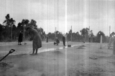 Greensborough Historical Society
Photograph - Digital image, Group Playing Tennis at Plenty, 1933, 1933_
Part of a collection of photographs owned by Dorris McLaughlin who was born in Greensborough, in 1899 to John McLaughlin and Rosalie Ellen Whatmough. The collection contains photographs of friends and relatives from the Greensborough and Eltham areas. This photograph shows a group of people playing tennis at Plenty, 1933.Digital copy of black and white photograph.dorris mclaughlin, plenty -
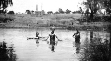 Malmsbury Historical Society
Photograph (Item), B/W Children Swimming In Coliban River, Malmsbury c1934
Buildings - "Coliban River, Mill" -
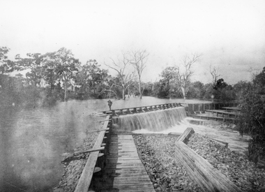 Stawell Historical Society Inc
Photograph, Wimmera River Weir at Glenorchy
Wimmera River Weir Glenorchywater -
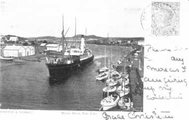 Port Fairy Historical Society Museum and Archives
Photograph - Photographic postcard, S.S.Casino in Moyne River 1905
This postcard features the S.S.Casino steaming into the Moyne river at Port Fairy after turning around in a "turning basin" situated further up the river it would then berth and disembark passengers and cargo onto the wharfPostcard featuring a photograph of S.S.Casino 1904 written on and stampedship, boat, sea, moyne river, s.s.casino, belfast and koroit steam navigation company -
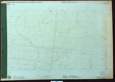 Greensborough Historical Society
Map, Melbourne and Metropolitan Board of Works. Survey Division, MMBW, Yarra 2500 / 14.25. Plenty, Heard Road, 1978_02
Melbourne and Metropolitan Board of Works. Yarra 2500 [base map] 14.25. Plenty, Heard Road. Parishes of Greensborough 2724, Nillumbik 3310 and Morang 3183. Municipality of Diamond Valley 257. Prominent streets include: Heard Road, Seymour Drive and Yan Yean Road.MMBW Map in 1:2500 [scale] series. Cream parchment with green tape reinforcing on edges and punched holes on left edge.mmbw, melbourne and metropolitan board of works, shire of diamond valley, plenty - maps -
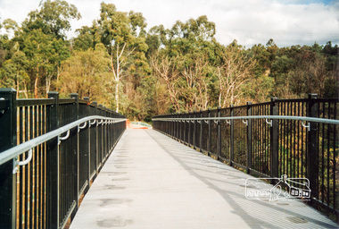 Eltham District Historical Society Inc
Photograph, Doug Orford, Completion of bridge works across Yarra River at rear of Eltham Lower Park, July 2004, July 2004
Brand new Eltham-Templestowe footbridge over the Yarra River off Homestead Road, Eltham which was completed in July 2004. The Yarra River Footbridge was opened in August 2004 and links the Diamond Creek Trail between the Shire of Nillumbik and City of Manningham. It is a shared pathway and also links with the Main Yarra Trail. It affords lovely views over the Yarra River.One of three colour photographs.yarra river, eltham south, eltham lower park, lenister farm, homestead road, shared pathway, diamond creek trail, footbridge -
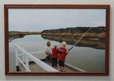 South Gippsland Shire Council
Photograph, Framed, Fishing on the Tarwin River, 2003
Framed and laminated colour photograph featuring a small group fishing from a timber pier on the Tarwin River. Shows a man and two blonde haired boys fishing holding rods. Laminated surface and brown timber frame. -
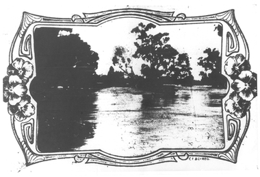
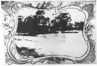 Tarnagulla History Archive
Photographs: Loddon River, Newbridge after flood, Loddon River, Newbridge after flood, 1909 (original image)
On 20th August,1909 the Laanecoorie Weir broke away and released 18.3 million cubic metres of water through the opening and causing severe damage to all towns downstream. At Newbridge, Petersen's bakery collapsed and Simpson's Store and Hotel flooded to the roof. The billiard table was later found in a tree five miles down the Loddon near Learmonth. Murray Comrie Collection. Two copies of a monochrome photograph, image depicts the area near Loddon River at Newbridge after major flood in 1909. This is a very grainy and dark copy of an older original. Copy probably made by Murray Comrie in the 1960s.newbridge, loddon river, flood, bridge -
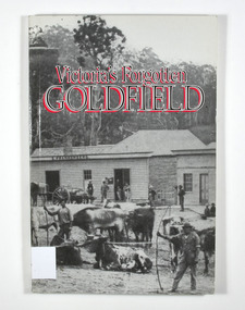 Marysville & District Historical Society
Book - Paperback book, Victoria's Forgotten Goldfield-A History of the Dargo, Crooked River Goldfield, 1996
A history of the Dargo, Crooked River goldfieldPaperback. Cover has a black and white photograph of a couple of buildings surrounded by forest. Photograph is probably of Dargo. One building has a sign that says S. Frankenberg. Another has a sign of which only the letters PION visible. In the photograph there are a number of men standing around the buildings as well as what appears to be two children sitting on a bench outside a building. There is also a large wagon-like vehicle to which is attached are a large train of oxen. In the foreground of the photograph is another group of oxen which appear to be chained together. There is also two men standing near the second group of oxen, both appear to be holding whips.The stamp of the Marysville & District Historical Society Inc / P.O. Box 22 / Marysville 3779gold, gold mining, gold town, dargo, gold miner, gold field, gippsland, victoria, australia, history