Showing 25582 items matching "plenty-township-estate"
-
 Greensborough Historical Society
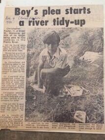
Newspaper Clipping - Digital Image, Boy's plea start Plenty River tidy-up, 09/12/1980
Christopher Foster, age 11, was sick of not being able to find yabbies in the Plenty River. He wrote to a local Councillor and asked that the River be cleaned up.Digital copy of newspaper article, black text and black and white image.plenty river, chris foster -
 Greensborough Historical Society
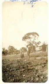
Photograph - Digital image, Caroline Barnett and Lower Plenty School, 1930c
Caroline Barnett with Lower Plenty School in background. Photographs from the collection of Peter Blackbourn, a descendant of the Chapman Stock family. Annotations to photos by Peter Blackbourn.Digital copy of black and white photograph.peter blackbourn, caroline barnett, lower plenty primary school -
 Greensborough Historical Society
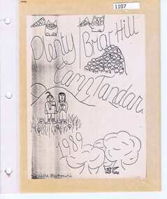
Photograph Album, Plenty/Briar Hill Camp 1989, 04/09/1989
Photographs and maps from Plenty/Briar Hill Camp 1989. Possibly a school project, includes itinerary. Photographs are not named. Location: "Tandara" Halls Gap.Colour photographs and maps in albumHand drawn front cover with name of artist.plenty, briar hill -
 Greensborough Historical Society
Photograph - Digital Image, Marilyn Smith, Log over the Plenty River near Willinda Park, 06/11/2017
This photograph shows a log over the Plenty River adjacent to Willinda Park. Willinda Park is situated in Beatrix Street Greensborough and has an athletics track and field. Digital copy of colour photographwillinda park, beatrix street greensborough, athletics, plenty river -
 Greensborough Historical Society
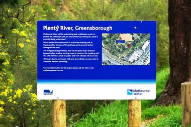
Photograph - Digital image, Marilyn Smith, Plenty River bank stabilisation 2015, 16/08/2015
River bank stabilisation project along the Plenty River at Greensborough 2015, conducted by Melbourne Water. Project sign and close-up of aerial view of site.Digital copy of colour photographplenty river, melbourne water -
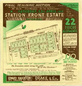 Whitehorse Historical Society Inc.
Document, Station Front Estate, 1940
Brochure advertising auction of 'Station Front estate'Brochure advertising auction of 'Station Front estate', Mitcham. 22 lots, 13 April 1940. Auctioneers Edward Haughton Pty Ltd, Drake & Co. Printed in two colours.Brochure advertising auction of 'Station Front estate'station front estate, auctions, calcutta street, mitcham, simla street, benares street, delhi street, mitcham road -
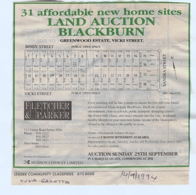 Whitehorse Historical Society Inc.
Document, Greenwood Estate, 14/09/1994 12:00:00 AM
subdivision of former Wunderlich site iAdvertisement for auction of 'Greenwood Estate', 31 sites, Vicki Street, Vicki Street 'Blackburn' (now Forest Hill), 25 September 1994. Agent: Fletcher & Parker. In Nunawading Gazettesubdivision of former Wunderlich site ibindy street, forest hill, vicki street, sandra street, greenwood estate, auctions -
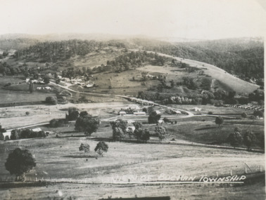 Lakes Entrance Historical Society
Postcard - Buchan Victoria, 1940 c
Black and white small postcard of township looking toward the hills beyond Buchan Victoria. Also two other postcards of Buchan Valley donated by Teena Daley and David PriceView of Buchan Townshiptownship, transport -
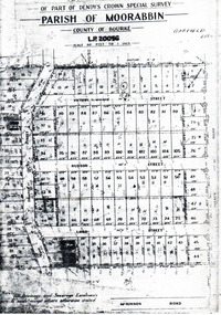 City of Moorabbin Historical Society (Operating the Box Cottage Museum)
Flyer - Garfield Estate, Ormond
At the end of World War One, there was a renewed interest in residential land and a number of estates opened up in the Municipality of Moorabbin.Example of the progress of the Municipality of MoorabbinPhotocopy of the plan of the Garfield Estate, OrmondPart f Dendy's Crown Special Survey - parish of Moorabbin - County of Bourke - Garfield Estatedraper street, lord street, hudson street, blackshaw street, tucker road, ormond, mckinnon, real estate -
 Warrnambool and District Historical Society Inc.
Map, Department of Lands and Survey (Lithographers), Caramut township, 1938
This map of the township of Caramut was produced in 1938 but shows the original land owners of each town allotment and of the surrounding area. The size of all the allotments and the date of the original purchase are also shown. Caramut is a Victorian Western District town on Mustons Creek on the Hamilton Highway 48 kilometres from Warrnambool. This map was used by Rolf Crawley when he was the engineer for the Shire of Warrnambool from 1935 to 1968. The annotations on the map have probably been made by Rolf Crawley as they refer to the records and letter books of his father, John William Crawley, Junior (Shire of Warrnambool Engineer 1895 to 1935). Both Rolf Crawley and his father, John had private businesses as architects, surveyors and engineers and the map could have been used in connection with both their official Shire duties and their private businesses. The last owner of the map was the surveyor, Michael Hand who took over the business of Rolf Crawley in the late 1960s. This map is of great interest firstly because it has all the historical details of the land first purchased in the town of Caramut and area and secondly because it came from the office of Rolf Crawley, the engineer for the Shire of Warrnambool from 1935 to 1968. This is a buff-coloured paper map with a cloth backing. The map details are in black and white print. There are some handwritten red and black annotations on the map. “Town of Caramut Parish of Caramut County of Villiers’town of caramut, john william crawley junior, warrnambool, rolf crawley, warrnambool -
 Kew Historical Society Inc
Plan - Subdivision Plan, Birdwood Estate, 1920
Pru Sanderson, in her groundbreaking ‘City of Kew Urban Conservation Study : Volume 2 - Development History’ (1988), summarised the periods of urban development and subdivisions of land in Kew. The periods that she identified included 1845-1880, 1880-1893, 1893-1921, 1921-1933, 1933-1943, and Post-War Development. These periods were selected as they represented periods of rapid growth or decline in urban development. An obvious starting point for Sanderson’s groupings involved population growth and the associated economic cycles. These cycles also highlighted urban expansion onto land that was predominantly rural, although in other cases it represented the decline and breakup of large estates. A number of the plans in the Kew Historical Society’s collection can also be found in other collections, such as those of the State Library of Victoria and the Boroondara Library Service. A number are however unique to the collection.The Kew Historical Society collection includes almost 100 subdivision plans pertaining to suburbs of the City of Melbourne. Most of these are of Kew, Kew East or Studley Park, although a smaller number are plans of Camberwell, Deepdene, Balwyn and Hawthorn. It is believed that the majority of the plans were gifted to the Society by persons connected with the real estate firm - J. R. Mathers and McMillan, 136 Cotham Road, Kew. The Plans in the collection are rarely in pristine form, being working plans on which the agent would write notes and record lots sold and the prices of these. The subdivision plans are historically significant examples of the growth of urban Melbourne from the beginning of the 20th Century up until the 1980s. A number of the plans are double-sided and often include a photograph on the reverse. A number of the latter are by noted photographers such as J.E. Barnes.Bordering Burke Road, the Birdwood Estate included a subdivision of 34 lots on either side of Birdwood Street, Balwyn. Six of the lots faced Burke Road. At the other end of the subdivision a line would indicate that a creek once bordered the subdivision. Lots were advertised for sale at a low figure on five-year terms. Purchasers could pay off the balance in twenty quarterly instalments (i.e. over five years).subdivision plans - balwyn, birdwood estate -
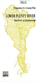 Greensborough Historical Society
Pamphlet, Melbourne & Metropolitan Board of Works, Lower Plenty River: Yarra River to Greensborough: preparation of a concept plan, 1990
This pamphlet outlines a proposed concept plan for the lower Plenty River, Greensborough to Heidelberg. The plan would focus on preserving and enhancing the aesthetic, recreational and conservation potential of the waterway.2 p., illus., tri-fold pamphlet. 2 copiesplenty river, melbourne water corporation, board of works -
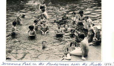 Greensborough Historical Society
Photograph - Digital image, Swimming pool, Plenty River 1952, 1952_
A group of children enjoy a swim in the Plenty River pool Greensborough in 1952. Opened in 1937, the remnants of this pool can be seen today. (Gary Partington is the boy in the centre).The remnants of this concrete pool can still be seen today.Digital copy of black and white photograph.greensborough swimming pool, plenty river swimming pool -
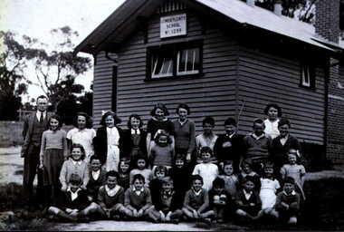 Greensborough Historical Society
Photograph - Digital image, Lower Plenty State School circa 1936-38 LP1295, 1936-1938
Lower Plenty Primary School circa 1936-1938. Photographs from the collection of Peter Blackbourn, a descendant of the Chapman Stock family. Annotations to photos by Peter Blackbourn.Digital copy of black and white photograph.peter blackbourn, lower plenty primary school -
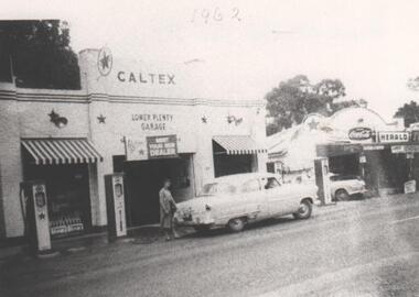 Greensborough Historical Society
Photograph - Digital image, Main Road Lower Plenty Garage 1962, 1962_
Caltex garage, Main Road Lower Plenty in 1962. Photographs from the collection of Peter Blackbourn, a descendant of the Chapman Stock family. Annotations to photos by Peter Blackbourn.Digital copy of black and white photograph.Date (1962) written on front of photograph.peter blackbourn, main road lower plenty, caltex garage lower plenty 1962 -
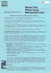 Greensborough Historical Society
Newsletter, Melbourne & Metropolitan Board of Works, Master Plan Plenty Gorge Metropolitan Park, 1991_06
The Parks Division of the Board was responsible for the preparation of a Master Plan for the management of the Plenty Gorge Metropolitan Park, comprising privately owned land and land owned by the Board and councils.The creation of the park by the Victorian government, to be managed by the Board of Works, guaranteed public access to a large area of land adjacent to the Plenty River Gorge.2p. newsletter, black ink on blue paperNewsletter No. 6plenty gorge park, plenty river -
 Greensborough Historical Society
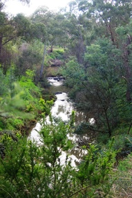
Photograph - Digital Image, Plenty River Greensborough May 2014 -1, 21/05/2014
The Plenty River flows south from Mt Disappointment before meeting with the Yarra River at Rosanna. These images taken in the Greensborough area. Photograph by Marilyn Smith 2014.Digital copy of colour photograph.plenty river, greensborough -
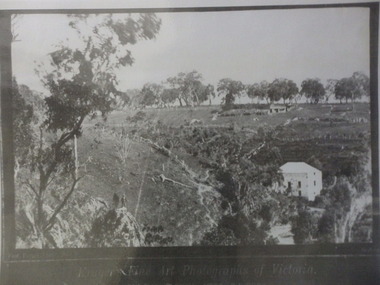 Greensborough Historical Society
Photograph (copy), Fred Kruger, On the Plenty River near Bundoora / photograph by Fred Kruger, 1877c
View of farm land and mill on the Plenty River near Bundoora, circa 1877; photograph by Fred Kruger. Original held at SLV (accession # H473 and Image # a53840)Black and white photograph, enlarged and laminated.fred kruger, plenty river -
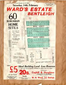 City of Moorabbin Historical Society (Operating the Box Cottage Museum)
Flyer - Ward's Estate, Bentleigh, 1920
At the end of World War One, there was a renewed interest in residential land and a number of estates opened up in the Municipality of Moorabbin.Example of the progress of the Municipality of MoorabbinAdvertising flyer for auction of real estate sales - plan of building blocks for saleWard's Estate Bentleigh Auction Saturday 14 February 1920centre road, smith street, ross street, jasper road, bentleigh, real estate, auction -
 Tarnagulla History Archive
Newspaper clipping: Plenty Of Puff But Where's The Bell?, Plenty Of Puff But Where's The Bell?, November 22, 1988
Donald Clark Collection. Clipping from The Bendigo Advertiser, of November 22, 1988, with article titled 'Plenty Of Puff But Where's The Bell?'. Discusses train services in the region and the celebration at Tarnagulla of the centenary of the town's passenger rail link. Reports on calls to restore the passenger rail services. Also describes the centenary celebrations which involved a race between teams carrying homemade replicas of steam trains. Images of the races and one of Donald Clark. Mentions the Tarnagulla Fire Brigade Senior and Junior teams and the Tarnagulla Golf Club Juniors team all as winners. tarnagulla, railways, rail, transport, trains, steam, centenary, centenaries, commemorations, community events, fire brigade, golf club, recreation reserve, races -
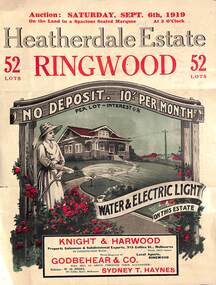 Ringwood and District Historical Society
Pamphlet - Land Auction Brochure, Heatherdale Estate, Ringwood, Victoria - 1919
Double sided leaflet advertising subdivision site, layout of streets and allotments, summary of local features and services and terms of sale. Inset photographs of local views and residence of F.W. Purches on the Estate.Auction Saturday September 6th, 1919. 52 Lots. Subdivision includes White Horse Road, Witt Street, Mitcham, Station Street (later Victory Street, Mitcham). (Railway Avenue marked on the map did not eventuate). Agents - Knight & Harwood, 315 Collins Street, Melbourne in conjunction with Godbehear & Co, Phone Ringwood 49, selling through their auctioneer - Sydney T. Haynes. Solicitor W.H. Peers, 395 Collins Street, Melbourne. -
 Whitehorse Historical Society Inc.
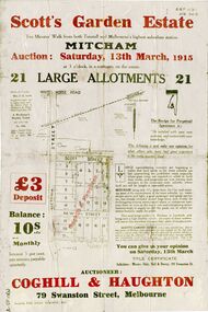
Document, Scott's Garden Estate, 1915
Brochure of Scott's Garden EstateBrochure of Scott's Garden Estate consisting of 21 large allotments owned by Mrs. E.E. Scott, corner Victoria Street and Scott Street, Mitcham. Also includes New Street, Mitcham. Brochure of Scott's Garden Estate scott, emma elizabeth, coghill & haughton, daly, hall & davey, scott's garden estate, scott street mitcham, victoria street mitcham, new street, mitcham -
 Whitehorse Historical Society Inc.
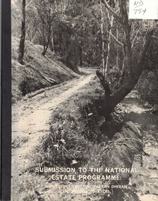
Document, Submission to the National Estate Programme, ca 1974
Submission to the National Estate Programme: Schwerkolt Cottage, Yarran Dheran and associated areas, City of Nunawading, 1974?.Submission to the National Estate Programme: Schwerkolt Cottage, Yarran Dheran and associated areas, City of Nunawading, 1974?. Includes 'Report on the survey of the vascular flora of the Yarran Dheran Reserve, by A.B. Court.Submission to the National Estate Programme: Schwerkolt Cottage, Yarran Dheran and associated areas, City of Nunawading, 1974?.city of nunawading, parks and reserves, schwerkolt cottage, yarran dheran, webster, noel, court, a.b., native plants -
 Kew Historical Society Inc
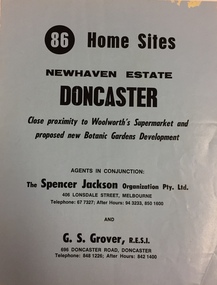
Plan - Subdivision Plan, New Haven Estate, Doncaster
Subdivision of 86 home sites in Doncaster.Undated subdivision plan for 86 home sites in the New Haven Estate in Doncaster. The 2-sided plan has a locality plan on the reverse.The land for sale would appear to be in George StreetNilnew haven estate - doncaster (vic), subdivision plans - doncaster (vic) -
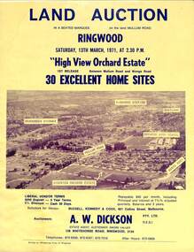 Ringwood and District Historical Society
Flyer, Land Auction Sale Brochure, High View Orchard Estate, Ringwood, Vic. - 1971
Double-sided advertisement for Ringwood High View Orchard Estate land auction sale on Saturday, 13th March, 1971, including aerial photograph, map, and summary of local facilities and services.Subdivision includes Wonga Road, Oban Road, Sang Court, Ambrie Avenue, Hendra Grove, and Mullum Mullum Road. Agent - A.W. Dickson Pty. Ltd., 136 Whitehorse Road, Ringwood, 3134. Telephones: 870 6000, 870 6007, 870 7016, after hours 870 6868. A separate copy of the advertisement includes a local newspaper follow-up clipping reports thirty home sites grossing $102,350 at the auction. -
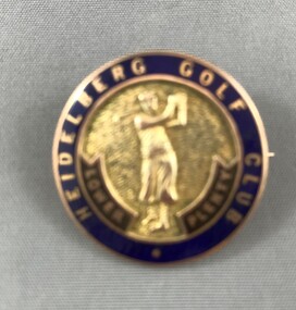 Heidelberg Golf Club
Decorative object - Badge, Heidelberg Golf Club, Ladies' monthly medal 1974, 1974
Small gold badge/pin awarded as a ladies' golf prize. Round metal and enamel badge in velvet presentation case; with female golfer in centre and Heidelberg Golf Club Lower Plenty inscribed around edge. Clasp on back "Heidelberg Golf Club Lower Plenty" on badge; "Dwayne" printed on presentation boxmonthly medal, ladies golf, badges, jeanne bennie -
![Newspaper Clipping - Digital Image, End of Plenty Bridge 1968 [Bluestone Bridge Greensborough], 16/04/1968](/media/collectors/4f729f5697f83e03086015b8/items/5eb3aa9d21ea670b94feceb5/item-media/5eb3acc621ea670b9400fd28/item-fit-380x285.jpg) Greensborough Historical Society
Greensborough Historical SocietyNewspaper Clipping - Digital Image, End of Plenty Bridge 1968 [Bluestone Bridge Greensborough], 16/04/1968
Removal of the bluestone bridge over the Plenty River in 1968. Photograph shows workmen removing the steel girders which covered the centre span. Pioneer Reserve is also mentioned.News clipping, black and white text and image.plenty river greensborough, bluestone bridge greensborough, pioneer reserve greensborough -
 Greensborough Historical Society
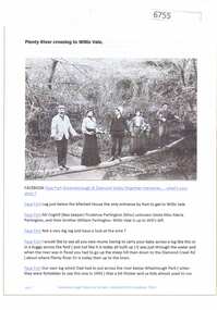
Article and Photograph, Plenty River crossing to Willis Vale, 2016_
Information and photo of members of the Partington family on the log crossing the Plenty River to the family's home at Willis Vale c1905. In the photo are Maria, Prudence and William Partington and Mr Coghill.This photograph and text was copied from a Facebook site. Members are people who lived in the Greensborough area and share their reminiscences of the area with others. The site is administered by a GHS member but is not officially affiliated with the Society. Any information is the opinion of the contributor. Article and photograph sourced from social media.willis vale, partington family, coghill, greensborough -
 Greensborough Historical Society
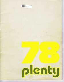
School Magazine, Plenty 78, 1978_
1978 edition of the Montmorency High School Yearbook "Plenty". Contains articles and photographs of students and teachers. There is a fold-out sheet with Year 12 students and a separate ticket to a dance.The Yearbook shows the people and activities associated with the school in 1978.48 pages, text and colour and black and white images. -
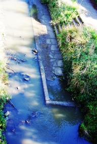 Greensborough Historical Society
Photograph - Digital Image, Old pool Plenty River, May 2014, 21/05/2014
Plenty River pool Greensborough. Opened in 1937, the remnants of this concrete pool can be seen today from the Main Street bridge Greensborough. Photograph by Marilyn Smith 2014.Digital copy of colour photograph.plenty river pool, greensborough pool, swimming pools