Showing 23795 items matching "r-p-jenkins"
-
 Melbourne Tram Museum
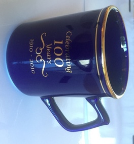
Decorative Object - China Cup, C. R. Hose Glassware Pty Ltd, "Celebrating 100 years 1910 - 2010", 2010
Black China cup with black handle, gold rim and gold line under the rim with a line drawing of the PMTT logo and "Celebrating 100 years 1910 - 2010" on the rear in gold. Has the C. R. Hose label as manufacturers and decorators on the base of the cup. Made to celebrate the 100th Anniversary of Malvern Depot - 2010.trams, tramways, crockery, malvern depot, pmtt -
 Linton Mechanics Institute and Free Library Collection
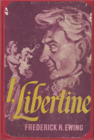
Book - Novel, Ewing, Frederick R, I, libertine, 1957
Tale of "moral adventurer" Lance Courtenay, who began life as Lancaster Higger-Piggott, a humble law clerk. Very loosely based on real events and people in the eighteenth century.221 p.: plain red cover, section of original dust jacket pasted to front cover, image of man leering at a partially clothed woman.'Blurb' from original dust jacket pasted inside front cover.fictionTale of "moral adventurer" Lance Courtenay, who began life as Lancaster Higger-Piggott, a humble law clerk. Very loosely based on real events and people in the eighteenth century.frederick r. ewing, historical fiction -
 Ballarat Tramway Museum
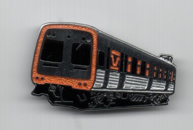
Badge - Comeng train, R. E. V Gomm, mid 1980's
Demonstrates a sales item that the museum has produced over many years.Metal lapel badge - image of VicRail Comeng Suburban train in orange livery - stamped metal badge with a clip on rear, nickel plated finish, with hand painted orange and black paint infilling the detail. Possibly made by R. E. V. Gomm, England to order of the Ballarat Tramway Museum mid 1980's.tramways, trams, badges, lapel badge, btm, railways -
 Kiewa Valley Historical Society
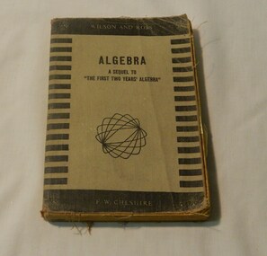
Book - Reference Maths, R. Wilson & A.D. Rose, Algebra A Sequel To
R. Wilson and A D Rose maths books were very popular and formed a basis of education maths classes in the 1950's in Victoria. This is what would have been used in Mt Beauty Secondary School at the time.This has historic significance as it shows what maths was taught in the early - mid 20th century. This book would have been used in the Kiewa Valley schools by a local identity Wilma Davies therefore has social significance and good interpretive capacity. This book is now out of print and is a collectible item. Black cover with strips on side of the front. Light brown centre with brown writing and squiggle pattern below.Publisher inscription - Wilson and Rossbook, school, text book, wilma davies, educational, maths -
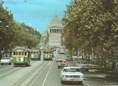 Melbourne Tram Museum
Postcard, John Sands - Sandscene International, "St Kilda Road and Shrine of Remembrance", mid 1970s
The photo of St Kilda Road and Shrine of Remembrance has six trams including W2 298 (route 8) and SW5 854 (route 72). Trams have been fitted with marker lights. Photograph by R Bell.Yields information about St Kilda Road mid 1970sColour postcard by Sandscene International, No. V22 with a serrated edge - No. JSC1216postcards, tram 298, tram 854, st kilda road, shrine of remembrance, route 8, route 72 -
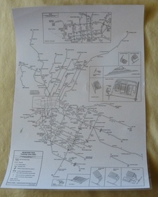 Melbourne Tram Museum
Poster, P. Sohns, "Melbourne Tram Track map (June 2006)", 2006
Poster - titled "Melbourne Tram Track map (June 2006)", line drawing on white paper, showing a detailed track map of junctions, depots, cross overs, route numbers, Preston Workshop, track out of service but overhead still in place, routes under construction of planning. Prepared by P. Sohns with Research by H. Waldron. Dated 8/4/2006. Has a detailed inserted of the city area. One unlaminated and one laminated copy held.trams, tramways, melbourne, map, tramways, depots, workshops, tram routes -
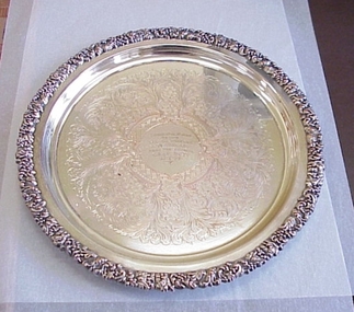 National Wool Museum
Plate
Silver serving plate, presented to Mr R W Pettitt on the occasion of his wedding anniversary, by the council of the Geelong Agricultural & Pastoral Society, 30-4-1963.Presented to Mr R W Pettitt on the occasion of his wedding anniversary, by the council of the Geelong Agricultural & Pastoral Society, 30-4-1963.CONGRATULATIONS/ ON YOUR/ SILVER WEDDING//ANNIVERSARY/ FROM THE COUNCIL/G A & P SC'TY/ 30.4.63geelong agricultural and pastoral society, pettitt, mr r. w. -
 Port Melbourne Historical & Preservation Society
Document, F R Tonkin, "History of SS No 1427, Nott St, Port Melbourne", 31 Mar 1969
"History of SS No 1427, Nott St, Port Melbourne". Photocopy of two typed pages signed by F R Tonkin 31 March 1969. Information is included about earlier schools : 542 Sandridge (National), 590 Sandridge (Wesleyan) and 602 Sandridge (Roman Catholic) that all closed after No 1427 opened on 1 July 1874.education - primary schools, built environment - civic, nott street state school -
 Ballarat Tramway Museum
Badge - Tait Train, R. E. V Gomm, mid 1980's
Demonstrates a sales item that the museum has produced over many years.Metal lapel badge - image of Victorian Railways Red Tait Suburban train in orange livery - stamped metal badge with a clip on rear, nickel plated finish, with hand painted red and black paint infilling the detail. Possibly made by R. E. V. Gomm, England to order of the Ballarat Tramway Museum mid 1980's.tramways, trams, badges, lapel badge, btm, railways -
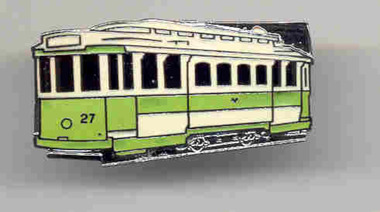 Ballarat Tramway Museum
Badge - Tram 27 Early SEC, R. E. V Gomm, c1996
Metal lapel badge - image of Ballarat Tramway Museum No. 27 in an early SEC green and cream livery - stamped metal badge with a clip on rear, nickel plated finish, with hand painted light green and white/cream paint infilling the detail. Made by R. E. V. Gomm, England to order for Travis Jeffrey c1996.tramways, trams, badges, lapel badge, btm -
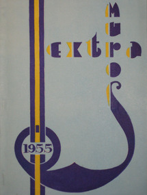 Federation University Historical Collection
Book, Extra Muros 1955, 1955
... jenkins ...1951 Ballarat Teachers’ College offers a two year trained Primary Teachers’ Certificate for the first time. (BTC Handbook 1965) December 1955 Ballarat Teachers’ College held its first Graduation Ceremony. The words of the Graduation Hymn were written by Mavis Canty. (BTC Handbook 1965)Light blue cover with dark blue and yellow text, back cover cream soft covered annual magazine of the Ballarat Teachers College. Includes yearly events. The Ballarat Teachers' College 1955 Second Year Students and Staff photo includes (left to right): Back row: C. ussing, R. Flavell, R. Jones, P. Dawson, W. Hughes, B. Williams, F. Tinney. 2nd row: B. Jones, B. Hancorne, R. Potter, I. Neilson, K. Holloway, I. Pritchard, G. Maggs. 3rd row: C. Handreck, Keith Hamilton, J. Carter, L. Harper, E. Lynes, J. Rae, B. McCleary, M. Joyce, J. Matthews, B. Harrison, E. Lewis, B. Moore. 4th row: D. Thompson, M. Bone, J. Cotter, C. Bolte, D. Powrie, L. Edge, S. Edwards, D. Cleary, B. McIntyre, F. Dridan, B. Connellan, L. Martin. 5th row: A. Nailon, M. McCallum, E. Medwell, M. Meagher, J. Butler, E. Dobson, J. Black, M. Anderson, W. Hanstock, M. Harris, G. Bowers. 6th Row: M. Casey, M. Crocker, B. Heath, W. Hall, U. Dempster, J. Burns, I. Bradshaw, J. Sanders, M. Williamson, Z. Walker, J. Brehaut, B. Boadle. 7th row: M. Fraser, Howard Pattenden, J. Gould, M. Byrne, A. Hancock. J. Murphy, M. Morgan, E. Ingleton, V. Rance, M. Walker, J.M. Blair, R.R. Reed. Front Row: J.M. Hill, J, Fox, A.H. Linton, Bob Croft, Ted Doney, Monica Miller, T.W.H. Turner, Mavis Canty, Alan Sonsee, E.O. Walpole, C.A. Pryor, C. Rodger, G.A. Jenkins. Has autographs on inside of back cover: John M Blair, Margaret R Chasey, Elizabeth Constable, Jean W Black, George A Jenkins, Clarice Handreckbtc, ballarat teachers' college, black, sanders, williamson, jm blair, c handreek, m meagher, e ingleton, w hall, s mclay, j roberts, bremner, flavell, chasey, mccleary, williams, ross, hamilton, keith hamilton, croft, bob croft, walpole, sonsee, canty, miller, pryor, turner, rodger, jenkins, linton, fox, hill, doney, pattenden -
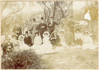 City of Moorabbin Historical Society (Operating the Box Cottage Museum)
Photograph, The Cheltenham Market Gardner's Picnic, The Gardner's Picnic pre 1914-18 War, pre 1914-18
The photograph is pre 1914-18. It is showing Cheltenham Market Gardeners having a picnic. The Market Gardeners gave Moorabbin it's first industry, which was to prove the most durable and resilient. The ladies and gentlemen are dressed in very fine clothes. All of the men are wearing suits with waistcoats and white shirts with neck ties. One man has a Boater hat , 4 have Bowler hats and 5 have Stetson hats. 5 men are standing and 4 men are kneeling or sitting with the ladies. The ladies are seated on the ground around a table runner on which items of food are seen. Most of the ladies are wearing white dresses, one lady has a dark coloured skirt with a white frilly blouse, and all have large wide brimmed fashionably decorated hats . They all seem to be dressed in their best clothes.The photograph depicts a group of men and women, 16 altogether, having a picnic pre World War 1 1914-1918 . They are surrounded by trees and bushes outside.Front of mount : R. McGeehan Photograph, Beechworth. Back of Mount Address Balaclava / C Whitehead / Gardeners Picnic / Pre World War 11914-18, moorabbin. picnic, market gardeners, early settlers, pioneers, moorabbin shire, cheltenham, fashion, dressmaking, bowler hats, boater hats, stetson hats, bonnets, chapeau, menswear, neckties, beechworth mcgeehan r, photographs, -
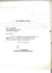 Melbourne Legacy
Letter - Document, letter
Letter from S. Jenkins of 159 Summerhill Rd, Glen Iris, requesting details on the advertised Legacy Club position. The reverse side was used to record the typed reply dated 25 February 1943, from E. Russell, Chairman of the Hostel Committee, that the appointment has now been made.A record of written correspondence regarding job applications in 1943.White quarto notepaper lined, black ink handwriting on one side, black typed on the other side, two hole punched.Signed S. Jenkins. Typed notation "Reply Overleaf"holmbush administration, residences -
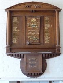 Wycheproof & District Historical Society Inc.
Photo, Mrs Elaine Storey, Wycheproof School Honour Roll 1914 - 1919, 1919
This plaque recognises the Wycheproof servicemen from State School No1757 who served in the 1914-1919 War. The actual large Honour Roll hangs in the old historic Wycheproof State School building.This Honour Roll contributes to and is part of the nation's collection of War Records; it is unique,believed to be the only one of its kind.PHOTO of large Wycheproof School Honour Roll WW1, on wall at the former Wycheproof S.S. No.1757 building - now the Mount Wycheproof Museum. The plaque of solid wood has cylindrical wooden pillars each side of the 55 gold inscribed names - 12 FALLEN servicemen and marked with a +. Raised wooden carved grapes and leaves adorn the top edge. In the centre, on the scroll are dedication words in Honour of the Brave Men From Wycheproof State School. A small wooden cupboard is attached underneath for War Service Records. This photo is in a display Book registered number 02089 at the Court House. Anderson, E. , Anderson, N. , Boyce W. , Bruce R. , Brotherson, H. , + Brotherson, L. , Barker, D. , Beardon, G., Currie N. , Currie, G. , Cutts, R. , Cutts, A. , Chisholm, A. , Cooper, C. , Duckmanton, S. , Dooley, N. , Dooley, J. , Donnelly, T. , Gibb, J.R. +Gregson A. , Hurcules, W. , Hurcules, C. , Hurcules, N. , + Hayes, L. , Hayes, G. , +Hotham, J. , Hindson, E. , Heap, A. , Holloway, V. , Headley, J. , + Kearney, P. , Matheson, H., Matheson, J. , Miles, H. , McDonald, G., McDonald, W., +W., McElphinney, D. , McElphinney, D. , Pratt, A. , + Orrock, P. , + Orrock, A. , + Robinson, S. , Redgen, J. , + Ryan, J.F. , + Slocombe, R. , Stewart, C. , Stewart, R. , Stavely, W. ,+ Sayers, W. , Secombe, W. , Taylor, R. , Tucker, C. , Thomas, R. , Wilson, S. , Ward, P. + Supreme Sacrifice Anderson, E. , Anderson, N. , Boyce W. , Bruce R. , Brotherson, H. , + Brotherson, L. , Barker, D. , Beardon, G., Currie N. , Currie, G. , Cutts, R. , Cutts, A. , Chisholm, A. , Cooper, C. , Duckmanton, S. , Dooley, N. , Dooley, J. , Donnelly, T. , Gibb, J.R. +Gregson A. , Hurcules, W. , Hurcules, C. , Hurcules, N. , + Hayes, L. , Hayes, G. , +Hotham, J. , Hindson, E. , Heap, A. , Holloway, V. , Headley, J. , + Kearney, P. , Matheson, H., Matheson, J. , Miles, H. , McDonald, G., McDonald, W., +W., McElphinney, D. , McElphinney, D. , Pratt, A. , + Orrock, P. , + Orrock, A. , + Robinson, S. , Redgen, J. , + Ryan, J.F. , + Slocombe, R. , Stewart, C. , Stewart, R. , Stavely, W. ,+ Sayers, W. , Secombe, W. , Taylor, R. , Tucker, C. , Thomas, R. , Wilson, S. , Ward, P. + Supreme Sacrifice wycheproof - school, honour roll, world- war-one, wycheproof- servicemen -
 Ballarat Tramway Museum
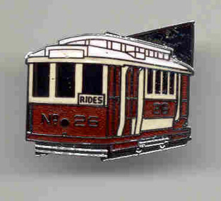
Badge - BTPS Tram 38, R. E. V Gomm, mid 2000's
Demonstrates a sales item that the museum has produced over many years.Metal lapel badge - image of Ballarat tram No. 38, with a BTM "Tram rides" sign - stamped metal badge with a clip on rear, nickel plated finish, with hand painted green, yellow and cream paint infilling the detail. Made by R. E. V Gomm the BTM, mid 2000's. 2nd copy added 6-2-2023tramways, trams, badges, lapel badge, btm, bogie trams -
 Flagstaff Hill Maritime Museum and Village
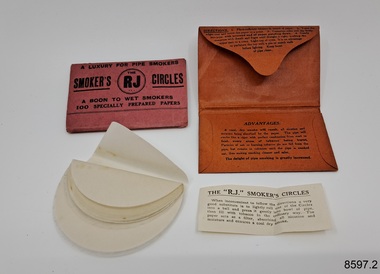
Equipment - Smoker's Circles, R J Reynolds, Unknown
These Smoker's Circles, used by Dr.William Roy Angus, Surgeon and Oculist, were donated to Flagstaff Hill Maritime Village by his daughter, Bernice McDade. It is part of the “W.R. Angus Collection” that includes historical medical equipment, surgical instruments and material once belonging to Dr Edward Ryan and Dr Thomas Francis Ryan, (both of Nhill, Victoria) as well as Dr Angus’ own belongings. The Collection’s history spans the medical practices of the two Doctors Ryan, from 1885-1926 plus that of Dr Angus, up until 1969. ABOUT THE “W.R.ANGUS COLLECTION” Doctor William Roy Angus M.B., B.S., Adel., 1923, F.R.C.S. Edin.,1928 (also known as Dr Roy Angus) was born in Murrumbeena, Victoria in 1901 and lived until 1970. He qualified as a doctor in 1923 at University of Adelaide, was Resident Medical Officer at the Royal Adelaide Hospital in 1924 and for a period was house surgeon to Sir (then Mr.) Henry Simpson Newland. Dr Angus was briefly an Assistant to Dr Riddell of Kapunda, then commenced private practice at Curramulka, Yorke Peninsula, SA, where he was physician, surgeon and chemist. In 1926, he was appointed as new Medical Assistant to Dr Thomas Francis Ryan (T.F. Ryan, or Tom), in Nhill, Victoria, where his experiences included radiology and pharmacy. In 1927 he was Acting House Surgeon in Dr Tom Ryan’s absence. Dr Angus had become engaged to Gladys Forsyth and they decided he would take time to further his studies overseas in the UK in 1927. He studied at London University College Hospital and at Edinburgh Royal Infirmary and in 1928, was awarded FRCS (Fellow from the Royal College of Surgeons), Edinburgh. He worked his passage back to Australia as a Ship’s Surgeon on the on the Australian Commonwealth Line’s T.S.S. Largs Bay. Dr Angus married Gladys in 1929, in Ballarat. (They went on to have one son (Graham 1932, born in SA) and two daughters (Helen (died 12/07/1996) and Berenice (Berry), both born at Mira, Nhill ) Dr Angus was a ‘flying doctor’ for the A.I.M. (Australian Inland Ministry) Aerial Medical Service in 1928 . The organisation began in South Australia through the Presbyterian Church in that year, with its first station being in the remote town of Oodnadatta, where Dr Angus was stationed. He was locum tenens there on North-South Railway at 21 Mile Camp. He took up this ‘flying doctor’ position in response to a call from Dr John Flynn; the organisation was later known as the Flying Doctor Service, then the Royal Flying Doctor Service. A lot of his work during this time involved dental surgery also. Between 1928-1932 he was surgeon at the Curramulka Hospital, Yorke Peninsula, South Australia. In 1933 Dr Angus returned to Nhill where he’d previously worked as Medical Assistant and purchased a share of the Nelson Street practice and Mira hospital from Dr Les Middleton one of the Middleton Brothers, the current owners of what was once Dr Tom Ryan’s practice. Dr L Middleton was House Surgeon to the Nhill Hospital 1926-1933, when he resigned. [Dr Tom Ryan’s practice had originally belonged to his older brother Dr Edward Ryan, who came to Nhill in 1885. Dr Edward saw patients at his rooms, firstly in Victoria Street and in 1886 in Nelson Street, until 1901. The Nelson Street practice also had a 2 bed ward, called Mira Private Hospital ). Dr Edward Ryan was House Surgeon at the Nhill Hospital 1884-1902 . He also had occasions where he successfully performed veterinary surgery for the local farmers too. Dr Tom Ryan then purchased the practice from his brother in 1901. Both Dr Edward and Dr Tom Ryan work as surgeons included eye surgery. Dr Tom Ryan performed many of his operations in the Mira private hospital on his premises. He too was House Surgeon at the Nhill Hospital 1902-1926. Dr Tom Ryan had one of the only two pieces of radiology equipment in Victoria during his practicing years – The Royal Melbourne Hospital had the other one. Over the years Dr Tom Ryan gradually set up what was effectively a training school for country general-practitioner-surgeons. Each patient was carefully examined, including using the X-ray machine, and any surgery was discussed and planned with Dr Ryan’s assistants several days in advance. Dr Angus gained experience in using the X-ray machine there during his time as assistant to Dr Ryan. Dr Tom Ryan moved from Nhill in 1926. He became a Fellow of the Royal Australasian College of Surgeons in 1927, soon after its formation, a rare accolade for a doctor outside any of the major cities. He remained a bachelor and died suddenly on 7th Dec 1955, aged 91, at his home in Ararat. Scholarships and prizes are still awarded to medical students in the honour of Dr T.F. Ryan and his father, Dr Michael Ryan, and brother, John Patrick Ryan. ] When Dr Angus bought into the Nelson Street premises in Nhill he was also appointed as the Nhill Hospital’s Honorary House Surgeon 1933-1938. His practitioner’s plate from his Nhill surgery states “HOURS Daily, except Tuesdays, Fridays and Saturday afternoons, 9-10am, 2-4pm, 7-8pm. Sundays by appointment”. This plate is now mounted on the doorway to the Port Medical Office at Flagstaff Hill Maritime Village, Warrnambool. Dr Edward Ryan and Dr Tom Ryan had an extensive collection of historical medical equipment and materials spanning 1884-1926 and when Dr Angus took up practice in their old premises he obtained this collection, a large part of which is now on display at the Port Medical Office at Flagstaff Hill Maritime Village in Warrnambool. During his time in Nhill Dr Angus was involved in the merging of the Mira Hospital and Nhill Public Hospital into one public hospital and the property titles passed on to Nhill Hospital in 1939. In 1939 Dr Angus and his family moved to Warrnambool where he purchased “Birchwood,” the 1852 home and medical practice of Dr John Hunter Henderson, at 214 Koroit Street. (This property was sold in1965 to the State Government and is now the site of the Warrnambool Police Station. ). The Angus family was able to afford gardeners, cooks and maids; their home was a popular place for visiting dignitaries to stay whilst visiting Warrnambool. Dr Angus had his own silk worm farm at home in a Mulberry tree. His young daughter used his centrifuge for spinning the silk. Dr Angus was appointed on a part-time basis as Port Medical Officer (Health Officer) in Warrnambool and held this position until the 1940’s when the government no longer required the service of a Port Medical Officer in Warrnambool; he was thus Warrnambool’s last serving Port Medical Officer. (The duties of a Port Medical Officer were outlined by the Colonial Secretary on 21st June, 1839 under the terms of the Quarantine Act. Masters of immigrant ships arriving in port reported incidents of diseases, illness and death and the Port Medical Officer made a decision on whether the ship required Quarantine and for how long, in this way preventing contagious illness from spreading from new immigrants to the residents already in the colony.) Dr Angus was a member of the Australian Medical Association, for 35 years and surgeon at the Warrnambool Base Hospital 1939-1942, He served as a Surgeon Captain during WWII1942-45, in Ballarat, Victoria, and in Bonegilla, N.S.W., completing his service just before the end of the war due to suffering from a heart attack. During his convalescence he carved an intricate and ‘most artistic’ chess set from the material that dentures were made from. He then studied ophthalmology at the Royal Melbourne Eye and Ear Hospital and created cosmetically superior artificial eyes by pioneering using the intrascleral cartilage. Angus received accolades from the Ophthalmological Society of Australasia for this work. He returned to Warrnambool to commence practice as an ophthalmologist, pioneering in artificial eye improvements. He was Honorary Consultant Ophthalmologist to Warrnambool Base Hospital for 31 years. He made monthly visits to Portland as a visiting surgeon, to perform eye surgery. He represented the Victorian South-West subdivision of the Australian Medical Association as its secretary between 1949 and 1956 and as chairman from 1956 to 1958. In 1968 Dr Angus was elected member of Spain’s Barraquer Institute of Barcelona after his research work in Intrasclearal cartilage grafting, becoming one of the few Australian ophthalmologists to receive this honour, and in the following year presented his final paper on Living Intrasclearal Cartilage Implants at the Inaugural Meeting of the Australian College of Ophthalmologists in Melbourne In his personal life Dr Angus was a Presbyterian and treated Sunday as a Sabbath, a day of rest. He would visit 3 or 4 country patients on a Sunday, taking his children along ‘for the ride’ and to visit with him. Sunday evenings he would play the pianola and sing Scottish songs to his family. One of Dr Angus’ patients was Margaret MacKenzie, author of a book on local shipwrecks that she’d seen as an eye witness from the late 1880’s in Peterborough, Victoria. In the early 1950’s Dr Angus, painted a picture of a shipwreck for the cover jacket of Margaret’s book, Shipwrecks and More Shipwrecks. She was blind in later life and her daughter wrote the actual book for her. Dr Angus and his wife Gladys were very involved in Warrnambool’s society with a strong interest in civic affairs. Their interests included organisations such as Red Cross, Rostrum, Warrnambool and District Historical Society (founding members), Wine and Food Society, Steering Committee for Tertiary Education in Warrnambool, Local National Trust, Good Neighbour Council, Housing Commission Advisory Board, United Services Institute, Legion of Ex-Servicemen, Olympic Pool Committee, Food for Britain Organisation, Warrnambool Hospital, Anti-Cancer Council, Boys’ Club, Charitable Council, National Fitness Council and Air Raid Precautions Group. He was also a member of the Steam Preservation Society and derived much pleasure from a steam traction engine on his farm. He had an interest in people and the community He and his wife Gladys were both involved in the creation of Flagstaff Hill, including the layout of the gardens. After his death (28th March 1970) his family requested his practitioner’s plate, medical instruments and some personal belongings be displayed in the Port Medical Office surgery at Flagstaff Hill Maritime Village, and be called the “W. R. Angus Collection”.The W.R. Angus Collection is significant for still being located at the site it is connected with, Doctor Angus being the last Port Medical Officer in Warrnambool. The collection of medical instruments and other items and equipment is culturally significant, being an historical example of medicine from late 19th to mid-20th century. Dr Angus assisted Dr Tom Ryan, a pioneer in the use of X-rays and in ocular surgery.'Two packets of Smoker's Circles.'' Smoker's The R J (in circle) Circles'. 'A Luxury for Pipe Smokers. A Boon to Wet Smokers. 100 Specially Prepared Papers.' (Directions for use are printed in detail on the back of each pack.)flagstaff hill maritime museum and village, great ocean road, shipwreck coast, pipes, smoking, r j reynolds -
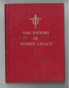 Melbourne Legacy
Book, Eric P Blashki, History of Sydney Legacy. Volume 3 July 1946 to July 1956, 1969
Red cloth covered hardcover edition of the Blaskhi's account of Sydney Legacy published in 1969.non-fictionhistory, sydney legacy, eric blashki -
 Waverley RSL Sub Branch
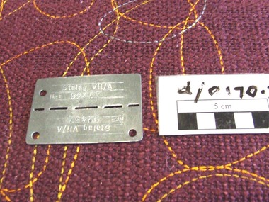
id tag Stalag V!!a and 2 postcards
Cpl A. P. Leach captured by Germans and sent to Stalag VII/A where he spent his 19th Birthday celebrated by a cake with "REAL FRUIT" from a food parcel. metal ID tag from Stalag VIIa with No. 92457 and 2 postcards from Cpl A. P. Leach to his Father R. W. LeachSTALAG VII/A Nr. 92457 pow, stalag vii/a -
Port Melbourne Historical & Preservation Society
Document, F. R. Tonkin, History of S.S. No. 1427, Nott St. Port Melbourne, 31 Mar 1969
The writer, F R TONKIN , has written a brief history of the Nott Street State School from its opening on 1st July 1874 to the end of March 1969. Due to falling enrolments the school closed in 1992 with the Port Phillip Specialist School relocating there in 1996.Two A4 typed sheets of information relating the history of Nott Street School until July 1969.1.7.1874 Nott St School Built Cost 5375.0.0 education - primary schools, state school 1427 nott street, f r tonkin -
 Ballarat Tramway Museum
Badge - Tram 26 - red, R. E. V Gomm, c1996
2773.1 - Metal lapel badge - image of Ballarat Tramway Museum No. 26 in a ESCo red and white livery - stamped metal badge with a clip on rear, nickel plated finish, with hand painted red and white paint infilling the detail. 2773.2 - as above but with a tie bar clip on rear. Made by R. E. V. Gomm, England to order for Travis Jeffrey c1996.tramways, trams, badges, lapel badge, btm, tie clip, esco -
 Rutherglen Historical Society
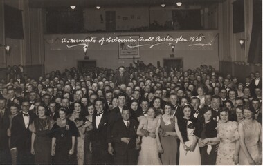
Image, N. R. McGeehan, 1935
Black and white postcard photograph of large group of people attending a ball.Written on a section of the photo: "A Memento of the Hibernian Ball, Rutherglen, 1935" On back of photo, in an oval stamp: "N. R. McGeehan, 154 Hotham St., Ripponlea, Photographer"ball, dances, hibernian ball -
 Ballarat Clarendon College
Book, W. and R. Chambers, Chambers's Cyclopaedia of English Literature: Volume 2
This book was awarded as the "Howard" prize to Robert A. Mitchell for Geography in 1879. Robert Mitchell, (D.O.B 9/2/1862), entered the College on 9th July, 1878. Robert is the son of Robert Mitchell who resided at Teragram Cottage, St. Arnaud. Bound in half calf with pebble grained cloth boards, marbled edges, gilt lettering and decoration on the spine. Six raised bands on spine with gold lettering on second and fourth compartments; College crest embossed on front cover; black and white illustrated, 816 p.Book plate inside front cover:College crest / Geography/the "Howard" prize/Sixth form/Awarded to/Robert A. Mitchell/Christmas, 1879.howard-prize, robert-a-mitchell, 1879, ballarat-college. -
 Eltham District Historical Society Inc
Photograph, P. Catchlove, Austin Hospital Appeal for Stage 2 Building Appeal, 4 Jul 1973
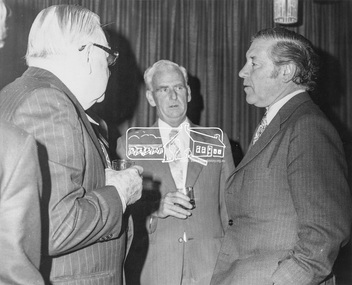
Luncheon reception held at Austin Hospital, Heidelberg to open appeal for the Stage 2 Building Appeal. L-R: Mr H. Foletta, Chairman of Austin Hospital Appeals Committee, Cr. J.O. White, J.P., Shire President, The Hon. R.J. Hamer, E.D., M.P., Premier of Victoria, and Treasuer and Minister of the Arts. The July 1973 appeal's target was $500,000, which with government subsidies aimed to pay for a nine-story building alongside stage one - a combined ten-storey teaching, research and medical centre. The new block was planned to provide the Austin Hospital with 218 additional beds, eight extra operating theartres and a comprehensive range of medical, diagnostic, therapeutic and anciliary services. The hospital conducted a door knock appeal in the Heidelberg and Eltham districts on Sunday July 22. This photo forms part of a collection of photographs gathered by the Shire of Eltham for their centenary project book,"Pioneers and Painters: 100 years of the Shire of Eltham" by Alan Marshall (1971). The collection of over 500 images is held in partnership between Eltham District Historical Society and Yarra Plenty Regional Library (Eltham Library) and is now formally known as the 'The Shire of Eltham Pioneers Photograph Collection.' It is significant in being the first community sourced collection representing the places and people of the Shire's first one hundred years.Digital image 120 format B&W negative EDHS_01922 (4 strips, 12 frames - Frame 9) Print 20 x 25 cmaustin hospital, austin hospital appeal, austin hospital appeals committee, cr. j.o. white, fundraising, h. foletta, heidelberg, hon. r.j. hamer, other areas, p.j. catchlove, premier of victoria, rupert hamer, sepp, shire of eltham pioneers photograph collection, shire president, victorian premier -
 Eltham District Historical Society Inc
Photograph, Austin Hospital Appeal for Stage 2 Building Appeal, 4 Jul 1973
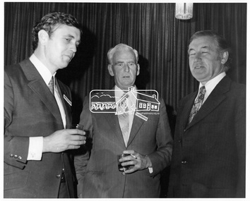
Luncheon reception held at Austin Hospital, Heidelberg to open appeal for the Stage 2 Building Appeal. L-R: Mr. Colin J. Bock, Shire secretary/Chief Administrative Officer, Cr. J.O. White J.P., Shire President, The Hon. R.J. Hamer, E.D., M.P., Premier of Victoria, and treasurer and Minister of the Arts. The July 1973 appeal's target was $500,000, which with government subsidies aimed to pay for a nine-story building alongside stage one - a combined ten-storey teaching, research and medical centre. The new block was planned to provide the Austin Hospital with 218 additional beds, eight extra operating theartres and a comprehensive range of medical, diagnostic, therapeutic and anciliary services. The hospital conducted a door knock appeal in the Heidelberg and Eltham districts on Sunday July 22.This photo forms part of a collection of photographs gathered by the Shire of Eltham for their centenary project book, "Pioneers and Painters: 100 years of the Shire of Eltham" by Alan Marshall (1971). The collection of over 500 images is held in partnership between Eltham District Historical Society and Yarra Plenty Regional Library (Eltham Library) and is now formally known as 'The Shire of Eltham Pioneers Photograph Collection.' It is significant in being the first community sourced collection representing the places and people of the Shire's first one hundred years.Digital image 120 format B&W negative EDHS_01922 (4 strips, 12 frames - Frame 8)austin hospital, austin hospital appeal, austin hospital appeals committee, colin j. bock, cr. j.o. white, fundraising, heidelberg, hon. r.j. hamer, other areas, p.j. catchlove, premier of victoria, rupert hamer, sepp, shire of eltham pioneers photograph collection, shire president, victorian premier -
 Ballarat Tramway Museum
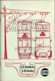
Book, G. E. Baddeley and E. R Oakley and, "Current Collection for Tramway and Trolleybus Systems", 1975
Book - 112 A5 pages + cover centre stapled, titled "Current Collection for Tramway and Trolleybus Systems", written by G. E. Baddeley and E. R Oakley, published by the authors in 1975. Has a table of contents - tramway overhead systems, current collection, trolley bus overhead, collection by bos and pantographs, peculiarities, surface contact systems and slot conduit systems, bibliography. Illustrated with diagrams. trams, tramways, overhead, trolley buses -
 Melbourne Tram Museum
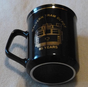
Domestic object - China Cup, C. R. Hose Glassware Pty Ltd, "Malvern Depot - 85 years", 1995
Black China cup or mug with black handle, gold rim and gold line under the rim and a line drawing of a W class tram No. 777 front, with destination "University" with the words "Malvern Tram Depot" around the top and "85 Years" along the bottom. Has the C. R. Hose label as manufacturers and decorators on the base of the cup. Made to celebrate the 85th Anniversary of Malvern Depot - 1995trams, tramways, crockery, malvern depot -
 Narre Warren and District Family History Group
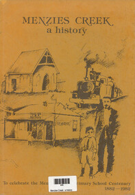
Book, R Hamilton et al, Menzies Creek : a history, 1982
Published in 1982 to celebrate the centenary of Menzies Creek Primary School (1882–1982). The book provides a detailed account of the history of Menzies Creek with illustrations, maps, and photographs, capturing the development of the area, including its gold mining origins, timber industry, and community milestones.Ochre cover with sketches depicting a church, train, general store and post office with a man and boy. Title at top of cover. Bottom of cover: To celebrate the Menzies Creek Primary School Centenary 1882-1982 64 p. : ill., facsims., maps, ports. ; 27 cm.non-fictionPublished in 1982 to celebrate the centenary of Menzies Creek Primary School (1882–1982). The book provides a detailed account of the history of Menzies Creek with illustrations, maps, and photographs, capturing the development of the area, including its gold mining origins, timber industry, and community milestones.menzies creek (vic.), menzies creek primary school (vic.) -
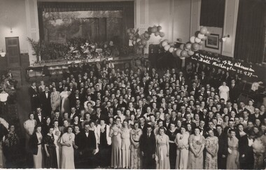 Rutherglen Historical Society
Image, N. R. McGeehan (Flash Light Specialist), 29/09/1937
Black and white postcard photograph of large group of people attending a ball.Written on a section of the photo: "Memento of the Hibernian Ball, Rutherglen, 29.9.37" On back of photo: "N. R. McGeehan, (Flashlight Specialist), 154 Hotham St., St. Kilda. S2"ball, dances, hibernian ball -
Tatura Irrigation & Wartime Camps Museum
Photograph - original, N. R. McGeehan photographer, Tatura Fire Brigade, 1933 original
Original photograph of Tatura Fire Brigade members, possibly 1933. C. J. Mitchell, T. Hogan, N. Mitchell, K. Williams, E. Francis, R. Dick, B. Ough, Anderson, L. Brady, T. Layton, Captain Bob Barron, J. Whelpdale, J. Brady, M. Pritchard and E. Mitchell.Original. Black and white photograph of members of Tatura Fire Brigade, on early fire truck.on back: names of members (see below) -
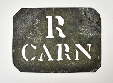 National Wool Museum
Stencil - R CARN
This stencil was used as a property name for the transportation of wool bales.Wool bale export stencil - R CARNR CARNwool sales, wool transport, wool export