Showing 3866 items
matching surveying-terrestrial
-
 Bendigo Military Museum
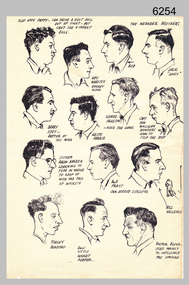
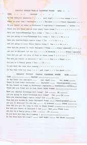
Drawing - Land Headquarters Cartographic Company’s Cricket Team Sketches, Fortuna, Bendigo, c1943
This is a page containing portrait profile sketches of 14 members of Fortuna’s cricket team, possibly taken from a booklet published at Bendigo’s Land Headquarters Cartographic Company circa 1943. Fortuna’s involvement in the Bendigo community and local sporting competitions in the 1940s is covered in page 31 of Valerie Lovejoy’s book 'Mapmakers of Fortuna – A history of the Army Survey Regiment’ ISBN: 0-646-42120-4. It is noted Fortuna’s Cricket Team competed in the summer of 1943. From the annotations of each individual’s name or nickname and other comments, the team members were probably V15403 SGT RC Papworth, 315649 HR Webster, V301426 SGT JR Neander, V510526 SPR RL Neander, VX85797 SGT WH Eddy, VX121647 SGT KH Harris, VX110276 CPL HM Jackson or VX119801 LR Jackson, VX37958 CPL DD Milligan, VX37958 SPR RJ Barber, VX85798 WO2 RR Pratt, VX85805 SGT GW Vallence, VX86152 CP LA Burford, V275492 SGT Ron Little and VF510725 SPR VM Bond or VX100878 WO2 WJ Bond. This is a page containing profile sketches of 14 members of Fortuna’s cricket team, possibly taken from a booklet published at Bendigo’s Land Headquarters Cartographic Company circa 1943. Each sketch is annotated with the individual’s name or nickname, and some have witty comments in relation to their cricketing prowess. The black and white A4 size portrait sketch was printed on a single buff manilla card and are part of the Army Survey Regiment’s Collection. The sketch was scanned at 300 dpi. Each sketch is annotated: Top Row L to R: SLAP HAPPY PAPPY - CAN DRIVE A GOLF BALL OUT OF SIGHT - BUT CAN’T SEE A CRICKET BALL, HEC. WEBSTER – HOOKEY KING, THE NEANDER BROTHERS BOB, JACK “LUCKY”. Second Row L to R: BARRY EDDY – BETTER AT THE MIKE, KEITH HARRIS, SCHNOZ JACKSON - NOSE THE GAME, CAPT. DON MILLIGAN WONDERS HOW TO STOP THE ROT. 3rd Row L to R: SCORER RALPH BARBER LEARNING TO TYPE IN ORDER TO KEEP UP WITH THE FALL OF WICKETS, BOB PRATT OUR HERBERT SUTCLIFFE, BILL VALLENCE, Bottom Row L to R: TORCHY BURFORD, RON LITTLE WICKET KEEPER, DOCTOR BOND – USED MAINLY TO INFLUENCE THE UMPIRE. royal australian survey corps, rasvy, army survey regiment, army svy regt, fortuna -
 Ringwood and District Historical Society
Report, Ringwood Primary School - Review Panel Report June 1987, Jun-87
The report contains school review seen as a channel for gaining independent opinion on the school's performance. Also included is a parent participation review, parent survey and responses, and a functioning & climate survey.Blue covered document with black spinex binding containing typed report of the Review Panel of Ringwood Primary School - June 1987 -
 Bendigo Military Museum
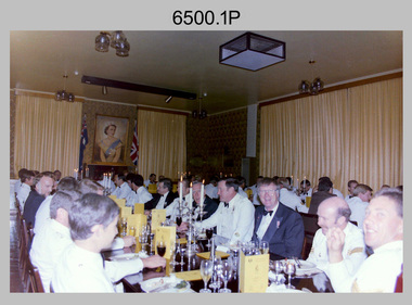
Photograph - 4th Field Survey Squadron Formal Dinner, Keswick Barracks, Adelaide SA, 1986
This is a set of 11 photographs of a 4th Field Survey Squadron Officers, Warrant Officers and Sergeants Formal Dinner held at Keswick Barracks, Adelaide SA in 1986. On this occasion WO1 Alex ‘Darby’ Munro and WO1 Geoff Briggs were farewelled. WO1 Munro retired from the Australian Regular Army after 30 years of service. WO1 Geoff Briggs continued his service and retired in 1991. It is apparent there were visiting personnel from the Army Survey Regiment and other unidentified units. See item 6501.35P for black & white photos taken at the dinner.This is a set of 11 photographs of a 4th Field Survey Squadron Officer, Warrant Officer and Sergeant’s Formal Dinner held at Keswick Barracks, Adelaide SA in 1986. The colour photographs are on 35mm negative film and are part of the Army Survey Regiment’s Collection. The photographs were scanned at 96 dpi. .1) - Photo, colour, 1986. Facing camera L to R: unidentified, Stevo Hinic, unidentified (x3), Bob Mason - Army Svy Regt’s RSM, unidentified, John Harrison, Roger Rees, Mick Hogan. .2) - Photo, colour, 1986. Facing camera L to R: unidentified, Malcolm Hentschel, unidentified, Bob Mason - Army Svy Regt’s RSM, unidentified, John Harrison, Roger Rees, Mick Hogan. Facing away from camera L to R: unidentified (x2), George Timmins. .3) - Photo, colour, 1986. Head table facing camera L to R: Ian Rose, Jorge Gruszka (Army Svy Regt’s CO), Don Taylor - OC, Darby Munro - Tech WO, Bill Griggs - SSM, Geoff Briggs, George Ricketts, unidentified RSM Keswick Barracks. .4) - Photo, colour, 1986. Left side of table: unidentified officer. Right side of table L to R: behind candles – Phil Smalley, Bob Mills, unidentified, Bob Garritty, Ian Rose. .5) - Photo, colour, 1986. Left table facing away from camera: Russell ‘Rusty’ Williams, unidentified. Left table facing camera L to R: unidentified, Peter Imeson, Dave Stephenson, Alan Brown, Bob Rogister, Wally Chilcott, unidentified, Barry Lutwyche OAM, Neil Jones, Bob Dickkenberg. .6) - Photo, colour, 1986. Head table facing camera L to R: Jorge Gruszka - CO Army Svy Regt , Don Taylor - OC, Darby Munro - Tech WO, Bill Griggs - SSM, Geoff Briggs, George Ricketts, unidentified RSM Keswick Barracks. Wearing suit in foreground - Bob Dickkenberg. .7) - Photo, colour, 1986. Left table facing away from camera: unidentified (x3), Gary Warnest, Ross Jenkins, Bruce ‘Stretch’ Gordon, unidentified (x2). Left table facing camera L to R: Bill Tewson, Peter Imeson, Dave Stephenson, Alan Brown, Bob Rogister, Wally Chilcott. .8) - Photo, colour, 1986. Left table facing camera L to R: Alan Brown, Bob Rogister, Wally Chilcott, unidentified, Barry Lutwyche OAM, Neil Jones, Bob Dickkenberg. .9) - Photo, colour, 1986. Facing away from camera: Dave Stephenson, unidentified (x2). Facing camera L to R: unidentified, Tony Gee, Brett ‘Dutchy’ Van Leeuwen, Bruce ‘Stretch’ Gordon, Ross Jenkins, Gary Warnest, unidentified (x2), Ray Sargeant, Stu Symonds. .10) - Photo, colour, 1986. Facing away from camera: Mick Hogan, Roger Rees, unidentified. Facing camera L to R: unidentified stewards (x2), unidentified (x2), Allan Adsett, Terry Lord, unidentified, Simon Reynolds – steward, George Timmins. .11) - Photo, colour, 1986. Head table L to R: Geoff Briggs, George Ricketts, unidentified RSM Keswick Barracks. Facing away from camera: unidentified, Neil Jones, remainder unidentified. Facing camera L to R: Steve Cooper, Darcy Patrick, Russell ‘Rusty’ Williams, John Scharber, Tony Gee, Brett ‘Dutchy’ Van Leeuwen..1P to .11P – There are no personnel identified. ‘1986 Formal Dinner’ annotated on negatives sleeve.royal australian survey corps, rasvy, 4 fd svy sqn -
 Eltham District Historical Society Inc
Document - Folder, Victoria Archaeological Survey, 1982-1990
sites, structures, archaeological significance, victoria archaeological survey -
 Ringwood and District Historical Society
Map - State Aerial Survey, Dandenong Ranges Area Sheet 7, Parishes of Warrandyte, Scoresby, Ringwood and Nunawading - 1956
Map of central and southern areas of Ringwood and part of Ringwood East and Heathmont compiled by Dept of Lands and Survey, July 1956, from aerial photographs and Cadastral Survey information. Subsequent coloured hand-drawn additions showing layout of a number of post-NSW Separation era proposed subdivisions that did not eventuate, including Village of Studley Estate, Township of East Kew Estate, Township of Ballyduffy Estate, Township of New Flemington Estate, Township of East Hawthorne Estate. Ringwood A4B2, 849 A4B Zone 7. Scale: 10 chains to 1 inch. Contour interval 20 feet. -
Bendigo Historical Society Inc.
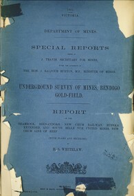
Map - K. K. MINE - TRANSVERSE SECTION K. K. MINE
Transverse Section of the K. K. Mine on the Hustler's Line of Reefs, Bulletin No 33, Plate No XXXII. Map shows the different levels and their depth. Also the different types of stone encountered and geological features such as spurs and faults. Has drawing of the poppet legs at the top of the shaft and sill of shaft 773.56 ft above sea level.Map has Geological Survey of Victoria crest and signed by H S Whitelaw, Underground Survey Office Bendigo, September, 1913. This item has not been scanned or photographed.cottage, miners, fortuna hustler's mine, transverse section of k. k. mine, hustler's line of reefs, geological survey of victoria, h s whitelaw -
Port Melbourne Historical & Preservation Society
Book - Reference, Gary Presland, Records of the Victorian Archeological Survey, 1977 - 1983
Purchased from Information Victoria, circa 2000Victorian Archeological Survey books by Gary Presland (editor or author). .01 - No5, 1977. Journals of George Augustus Robinson Jan -March 1840 (light orange cover 96 pages plus fold out route map) .02 - No 6 1977. Journals of George Augustus Robinson March - May 1841 (orange cover 102 pages plus fold out route map and illustrations) .03 - An archeological survey of the Melbourne Metropolitan area 1983 (yellow cover 136 pages)australian aborigines, natural environment, gary presland, george augustus robinson, archeology -
 Bendigo Military Museum
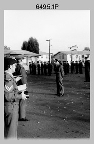
Photograph - Army Survey Regiment – Corps Day Parade, 1983
These photographs were taken at the Corps Day parade at the Army Survey Regiment, Bendigo in July 1983. This was the Director of the Survey Corps – COL John Hillier’s last parade at Fortuna before his retirement. COL Hillier, often referred to as ‘NRJ’ (his initials) was Director for five years. COL Alex W. Laing attended the parade as his successor, seen in the foreground of photos .5P and .6P. COL Hillier was appointed a couple of years later to the honorary position of Colonel Commandant of the Royal Australian Survey Corps from 1989 to 1993. COL Laing was Director of RASvy from July 1983 to November 1988. Corps Day Parades were held to commemorate the formation of the Royal Australian Survey Corps in July 1915.This is a set of 19 photographs of a Corps Day parade at the Army Survey Regiment, Bendigo in July 1983. The negatives of the photographs were scanned at 96 dpi. .1) - Photo, black & white, 1983, L to R: CPL Di Chalmers, CPL Dave Cook, unidentified, SGT Bob Bright, unidentified, SPR Dave Wright, SGT Josh Degroot, SPR Chad Hardwick. .2) - Photo, black & white, 1983, L to R: LT Karen (Adams) Byrne, CAPT Roger Rix, RSM WO1 Bob Mason, MAJ Bob Roche, CO LTCOL Jorge Gruszka, CAPT Mick Byrne, Director COL John Hillier, CPL Terry Danger, CPL Paul Richards, CPL Greg Sulman, CPL George Holland, CPL Roger Pearson, LT Terry Lord, CPL Warren ‘Wah’ Hall. .3) - Photo, black & white, 1983, L to R: unidentified personnel, Director COL John Hillier, SPR Ben Tarasenko, CAPT John Bloor, unidentified, RSM WO1 Bob Mason, CPL John Bettridge, SPR Tom Bloxham. .4) - Photo, black & white, 1983, L to R: unidentified, MAJ Bob Roche, CO LTCOL Jorge Gruszka, Director COL John Hillier, MAJ Stan Vote. .5) - Photo, black & white, 1983, L to R: Colonel Alex W. Laing – foreground, CO LTCOL Jorge Gruszka, MAJ Bob Roche. .6) - Photo, black & white, 1983, L to R: Director COL John Hillier, MAJ Jim Mitchell – background, Colonel Alex W. Laing - foreground, CO LTCOL Jorge Gruszka, unidentified, SGT Kevin Boehm, SGT Jim Beard, unidentified, CAPT Dave Sankey .7) - Photo, black & white, 1983, L to R: CAPT John Bloor, CAPT Andy McLeod, SGT Kevin Boehm, MAJ Bob Roche, SGT Jim Beard, CO LTCOL Jorge Gruszka, Director COL John Hillier, SSGT Bill Kemp, CPL Peter (Jack) Elvard, SGT Bob Croxton, CAPT Dave Sankey, CPL Mick Minchin, SGT Bruce Wetzig, CPL Ken Talbot-Smith. .8) - Photo, black & white, 1983, L to R: CAPT John Bloor, RSM WO1 Bob Mason, Director COL John Hillier, CO LTCOL Jorge Gruszka, MAJ Graham Baker. .9) - Photo, black & white, 1983, L to R: CAPT John Bloor, RSM WO1 Bob Mason, Director COL John Hillier, MAJ Bob Roche, CO LTCOL Jorge Gruszka, MAJ Graham Baker. .10) - Photo, black & white, 1983, L to R: CAPT Chris Mazur, CAPT John Bloor, CO LTCOL Jorge Gruszka, MAJ Graham Baker, SPR Steve Coulson, SGT Harald Mai, Director COL John Hillier, SPR Viv (Hawkins) Doherty, unidentified, SPR Tony Grivell, SPR Ross Collishaw, SGT Phil Meagher, SSGT Brett ‘Dutchy’ Van Leeuwen. .11) - Photo, black & white, 1983, L to R: CO LTCOL Jorge Gruszka, MAJ Graham Baker, SPR Tony Grivell, SPR Ross Collishaw, Director COL John Hillier, SGT Phil Meagher, SPR Peter Peterson, SSGT Brett ‘Dutchy’ Van Leeuwen, SGT Bruce Bowers, SGT Mick Davy, SPR Gerry Gates. .12) - Photo, black & white, 1983, L to R: SSGT Bruce ‘Stretch’ Gordon, SGT George Timmins, CO LTCOL Jorge Gruszka, Director COL John Hillier, MAJ Graham Baker, CAPT John Bloor, MAJ Bob Roche, WO2 Ted Burgess, RSM WO1 Bob Mason, WO2 Peter Biorac, WO1 Graeme Birrell. .13) - Photo, black & white, 1983, L to R: CO LTCOL Jorge Gruszka, CAPT John Bloor, Director COL John Hillier, inspecting rank R to L: SSGT Peter Barrett, CPL Gary Drummond, SPR Peter Breukel, CPL Ian Nichols, unidentified personnel. .14) - Photo, black & white, 1983, L to R: CO LTCOL Jorge Gruszka, Director COL John Hillier, MAJ Stan Vote, SSGT Peter Barrett, RSM WO1 Bob Mason, CPL Gary Drummond, SPR Peter Breukel, CPL Ian Nichols, unidentified. .15) - Photo, black & white, 1983, L to R: SGT John Cain, SSGT Jim Cook, CAPT John Bloor, CO LTCOL Jorge Gruszka, MAJ Stan Vote, Director COL John Hillier, CPL Keith Quinton, CPL Mick Gillham, CPL Kim Reynolds, SPR Paul Baker, WO1 Ken Slater, SPR Brian Fauth, SPR Jim Ash, WO2 George Graham, SGT Gavin Neilson. .16) - Photo, black & white, 1983, L to R: MAJ Bob Roche, MAJ Stan Vote, CPL Kim Reynolds, CO LTCOL Jorge Gruszka, Director COL John Hillier, WO2 George Graham, CPL John ‘Flash’ Anderson, SPR Gary Tremain, WO1 Ken Slater. .17) - Photo, black & white, 1983, L to R: MAJ Stan Vote, CO LTCOL Jorge Gruszka, Director COL John Hillier, WO1 Noel ‘Nesty’ Coulthard. .18) - Photo, black & white, 1983, L to R: LTCOL Jorge Gruszka, Director COL John Hillier, unidentified civilians. .19) - Photo, black & white, 1983, L to R: Director COL John Hillier, LTCOL Jorge Gruszka, RSM WO1 Bob Mason..1P to .19P – There are no personnel identifiedroyal australian survey corps, rasvy, army survey regiment, army svy regt, fortuna, asr -
 Bendigo Military Museum
Photograph - Army Survey Regiment –Defence Force Service Medal Presentations, Fortuna Villa, Bendigo, 1982
This is a set of 18 photographs of the presentation of the Defence Force Service Medal to personnel in recognition of 15 years of efficient remunerated service, or the Clasp for 5 years of additional service, at the Army Survey Regiment, Bendigo circa 1982. All medal recipients were from Lithographic trades.This is a set of 18 photographs of the presentation of the Defence Force Service Medal, at the Army Survey Regiment, Bendigo circa 1982. The black & white photographs are on 35mm negative film and are part of the Army Survey Regiment’s Collection. The photographs were scanned at 96 dpi. .1) - Photo, black & white, c1982. L to R: SGT Greg Anderson, CO LTCOL Jorge Gruszka AO, WO1 Noel ‘Nesty’ Coulthard, unidentified officer. .2) - Photo, black & white, c1982. L to R: LT Terry Lord, SGT Greg Anderson, CO LTCOL Jorge Gruszka AO, WO1 Noel ‘Nesty’ Coulthard, WO2 George Austen, unidentified officer, MAJ Jim Mitchell. Unidentified personnel in background. .3) - Photo, black & white, c1982. L to R: SGT Greg Anderson, CO LTCOL Jorge Gruszka AO, WO1 Noel ‘Nesty’ Coulthard, WO2 George Austen, WO2 George Graham, MAJ Jim Mitchell, CPL Eddie Jacobs, CPL Doug Home, remaining personnel in background unidentified. .4) - Photo, black & white, c1982. L to R: SGT Greg Anderson, CO LTCOL Jorge Gruszka AO, WO1 Noel ‘Nesty’ Coulthard, WO2 George Austen, WO2 George Graham, MAJ Jim Mitchell, WO2 John McCracken, CPL Doug Home, remaining personnel in background unidentified. .5) - Photo, black & white, c1982. L to R: WO1 Noel ‘Nesty’ Coulthard, WO2 George Austen, WO2 George Graham, MAJ Jim Mitchell, WO2 John McCracken, CPL Doug Home, CPL Graham Johnston, unidentified, SGT Garran Hill, LT Dave Sankey, remaining personnel in background unidentified. .6) & .7) - Photo, black & white, c1982. L to R: CO LTCOL Jorge Gruszka AO, WO1 Noel ‘Nesty’ Coulthard, WO2 George Austen. Unidentified personnel in background. .8) & .9) - Photo, black & white, c1982. L to R: CO LTCOL Jorge Gruszka AO, WO2 George Austen. Unidentified personnel in background. .10) to .12) - Photo, black & white, c1982. L to R: CO LTCOL Jorge Gruszka AO, WO2 George Graham. Unidentified personnel in background. .13) - Photo, black & white, c1982. WO2 John McCracken. Unidentified personnel in background. .14) to .15) - Photo, black & white, c1982. L to R: CO LTCOL Jorge Gruszka AO, WO2 John McCracken. Unidentified personnel in background. .16) - Photo, black & white, c1982. SGT Garran Hill. Unidentified personnel in background. .17) to .18) - Photo, black & white, c1982. L to R: CO LTCOL Jorge Gruszka AO, SGT Garran Hill. MAJ Jim Mitchell, CPL Eddie Jacobs, CPL Doug Home in background.There are no personnel identified. royal australian survey corps, rasvy, army survey regiment, army svy regt, fortuna, asr, litho sqn -
 Ringwood and District Historical Society
Newspaper, Scrapbook Clipping, Library Collection, Ringwood, Victoria
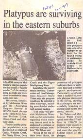
Newspaper Clipping from "The Post", 14 January 1997, Page 11, "Platypus are surviving in the eastern suburbs"'.A major survey of Melbourne's platypus population has found a "healthy number" of the animals living in creeks and rivers close to residential area in the outer east. Conservation and Land Management Minister, Marie Tehan, was present at the launching of the survey results, and spoke in detail about the results and the future planning and financial aid for the health of the Melbourne waterways. -
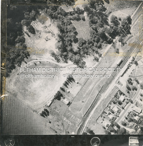
 Eltham District Historical Society Inc
Photograph - Aerial Photograph, Main Road Hurstbridge, corner of Rose Ave, 12 Apr. 1954
Victorian Railways Aerial Surveyshire of eltham archives, aerial photo, main road, anzac avenue, hursbridge, parker road, hurstbridge railway station, rose road -
 Eltham District Historical Society Inc
Photograph - Aerial Photograph, Main Road, Hurstbridge; Rose Road to Anzac Avenue including Railway Station area, 12 Apr. 1954
Victorian Railways Aerial Surveyshire of eltham archives, aerial photo, main road, anzac avenue, hursbridge, parker road, hurstbridge railway station, rose road -
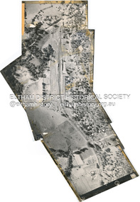
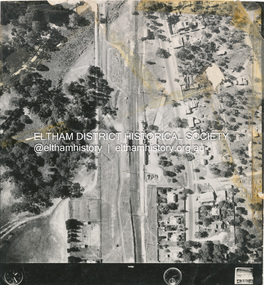
 Eltham District Historical Society Inc
Photograph - Aerial Photograph, Main Road Hurstbridge, Rose Ave to Parker Road, 12 Apr. 1954
Victorian Railways Aerial Surveyshire of eltham archives, aerial photo, main road, anzac avenue, hursbridge, parker road, hurstbridge railway station, rose road -
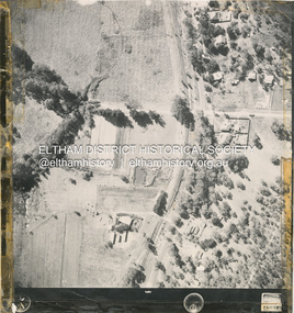
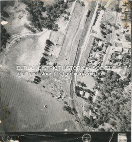
 Eltham District Historical Society Inc
Photograph - Aerial Photograph, Main Road and Railway Station area, Hurstbridge, 12 Apr. 1954
Victorian Railways Aerial Surveyshire of eltham archives, aerial photo, main road, anzac avenue, hursbridge, parker road, hurstbridge railway station, rose road -
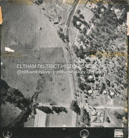
 Eltham District Historical Society Inc
Photograph - Aerial Photograph, Main Road and Railway Station area, Hurstbridge, 12 Apr. 1954
Victorian Railways Aerial Surveyshire of eltham archives, aerial photo, main road, anzac avenue, hursbridge, parker road, hurstbridge railway station, rose road -
 Eltham District Historical Society Inc
Photograph - Aerial Photograph, Main Road and Railway Station area, Hurstbridge, 12 Apr. 1954
Victorian Railways Aerial Surveyshire of eltham archives, aerial photo, main road, anzac avenue, hursbridge, parker road, hurstbridge railway station, rose road -
Tatura Irrigation & Wartime Camps Museum
Booklet, VAS News, 1989
Soft cover magazine, illustrated. Photograph of old man and 2 boys on front cover. Newsletter No. 6. Spring 1989-90. 16 pages.vas news, archalological survey, tatura, archaeology, books, newsletters -
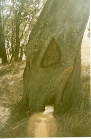 Stawell Historical Society Inc
Photograph, Survey Tree with markings at Lake Lonsdale -- 2 Photos
Survey Tree at Lake Lonsdalestawell -
Glenelg Shire Council Cultural Collection
Negative - Negative - View of Portland Harbour, 1961
NEGATIVE FOR BLACK AND WHITE PHOTOGRAPH. View of Portland Harbour from Henty Beach. Fishermens Breakwater on right, Ocean Pier, Railway pier on left, fishing boats at anchor, surveying pegs on beach in foregroundzillah maschmedt, portland harbour -
 Orbost & District Historical Society
book, 1922
William Hunter (1893-1971), resident of Tatura and Mallacoota was a soldier, surveyor and amateur naturalist.This item is associated with William Hunter.A black covered book of astronomical observations and results handwritten on lined pages. Inside is a blotter - "Reed Bros Tomato Sauce" ; an envelope addressed to "William Hunter Esquire Survey Camp Tubbut" and three stamps.hunter-william astronomy science -
 Federation University Historical Collection
Plan, Scarsdale County of Grenville, 1889, 26/01/1889
Rectangular plan of a geological survey edged in masking tape. It is predominantly grey, pink and green, but has some yellow. scale is 40 chains to one inch. (see Cat. No. 1098 for report on the Parish of Scarsdale)scarsdale, grenville, krause, browns and scarsdale, mopianimum, watershed, yarrowee, woady yalloak, timber reserve, department of mines, plans, cgt, crown lands, ferdinand krause -
 Bendigo Historical Society Inc.
Document - FORM OF SERVICE: FUNERAL OF LATE LT.COL. SPRENGER
Form of Service - Funeral of late Lt.Col. Sprenger at All Saint's Presbyterian Church Bendigo 9/12/1970. Cream coloured brochure - front page has an emblem for the Royal Australian Survey Corpsperson, individual, lt. col. sprenger -
Bendigo Historical Society Inc.
Map - WELLSFORD : COUNTY OF BENDIGO, 6-10-03
Map. Wellsford, County of Bendigo, Bagshot, Ellesmere, Axedale, Hunty, Sandhurst, Strathfieldsaye. Photo-Lithograph ed at the Department of Lands and Survey Melbourne. 6-10-03. (number 21 in map cupboard 1)T.E. McGearsonmap, bendigo, wellsford -
Port Melbourne Historical & Preservation Society
Letter - Department of Lands and Survey re proclaimation for site of Town Hall, Sandridge, Department of Lands and Survey, 30 Dec 1861
Handwritten letter on blue foolscap laid paper, from Dept of Lands and Survey 30.12.1861 directing attention to proclamation in Government Gazette re site for Town Hall at Sandridge. Paper, watermarked with Britannia symbollocal government - borough of sandridge, port melbourne town hall -
Bendigo Historical Society Inc.
Document - HARRY BIGGS COLLECTION: MAP - BENDIGO
Document. Harry Biggs Collection. A very rough hand drawn map of Pall Mall area taking in Police Court, Survey Office, Dudley House, Stockade, Fire Brigade, Camp & commissioners Gully.place, building, public buildings, harry biggs collection, map, bendigo -
Bendigo Historical Society Inc.
Map - LOCAL AREA PLANS, See above
Map: Compilation of maps: Village of Redcastle dated april 14 1861, Township of Yarraberb dated 14 July 1874, Hamlet of White Hills dated December 27 1872, Road survey of Toolleenmap, parish plan, redcastle, yarraberb, white hills, toolleen -
 Bendigo Historical Society Inc.
Book - UNDERGROUND SURVEY OF MINES, BENDIGO GOLDFIELD 1901, 1901
UNDERGROUND SURVEY OF MINES, BENDIGO GOLDFIELD 1901. Report on the Shamrock, Shenandoah, New Chum Railway, Eureka Extended, and South Belle Vue United Mines, New Chum Line of Reef. With plans and sections.H.S. Whitelawbendigo, hospital, gold mining, bendigo, goldfields, gold mining, shamrock, shenandoah, new chum railway, eureka extended, and south belle vue united mines, new chum line of reef. -
 Victorian Aboriginal Corporation for Languages
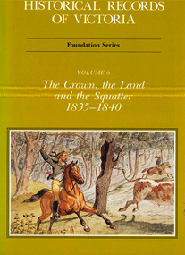
Book, Michael Cannon, Historical records of Victoria : foundation series : volume 6 : the crown, the land and the squatter 1835-1840, 1991
Reproductions of various transactions and reports dealing with squatting, land tenure and agricultural production in Port Phillip in the years 1835-1840. A history of land grants, surveying, squatters? life and land use during this period.maps, b&w illustrations, colour illustrationsvictorian history -
 Ballarat Tramway Museum
Document - Form/s, Ballarat Tramway Preservation Society (BTPS), "Ballarat Tourist Tramway Passenger Survey", 1975
Duplicated sheet of foolscap paper, titled "Ballarat Tourist Tramway Passenger Survey", - form. Has two forms per sheet - layout different, but questions the same. Used 1975. Asks 15 questions.trams, tramways, btps, forms, surveys -
University of Melbourne, Burnley Campus Archives
Plan, Plan of Richmond Park, 1872
Plan of Richmond Park L4461. Shows Horticultural Society's Garden without extra land used for Field Station (see 11.0363, but earlier). Photo-lithographed at the Department of Lands and Survey, 6th Sept. 1872.Handwritten notes on reverse and another railway line marked in pencil.richmond, parks, field station