Showing 124165 items
matching main-road
-
 Glen Eira Historical Society
Document - Otira Road, 6, Caulfield North 3161
Copy of letter by unnamed Valuer No 205 to H.H. Held, occupier of property at 6 Otira Rd, Caulfield North. Both sides of sheet States details of house. Handwritten signed notes on valuation of 6 Otira Road. List of other house sites, with prices. (2 sheets) Handwritten list of dimensions for each room and outhouses at 6 Otira Rd, Caulfield North. Handwritten note with dimensions, details and comments.otira road, brick houses, aroona road, caulfield north, howitt road, held h.h., architectural features. -
Glen Eira Historical Society
Document - St Aloysius Church, Caulfield
A photocopy of a document dated 26/05/1974 celebrating the fiftieth anniversary of the first Parish Mass in 1924 at St Aloysius Church Balaclava Road, Caulfield. The document lists the Catholic Priests and dignitaries who presided over the first Mass on 25/25/1924. A thanks to the past Parish priests from 1919 to 1974. Also included are three photocopies, of varying clarity, of a photograph of the front view of S1t Aloysius.st aloysius church, churches, festivals and celebrations, caulfield, architectural features, church services, parish of caulfield, architectural styles, balaclava road, clergy, people associated with religion, catholic church, bishops, mannix archbishop, daly t. rev fr., cooney h mr, o’ brien john a. rev. fr., o’ toole f. j. fr., hannan k fr., creed v. fr., kelly j. a bishop, knox cardinal. -
Glen Eira Historical Society
Plan - North Road, 631, Ormond
Documents concerning valuations for mortgage on the house at 631 North Road Ormond. Includes letter requesting valuation from Union Trustee Co. of Australia Ltd to W.V. Scott from Mrs. L.E. Leahy’s loan dated 08/11/1955, valuation with detailed description and plan dated 17/11/1955. Also a valuation by W.V. Scott dated 06/03/1961 for Mrs. L.E. Leahy’s mortgage.ormond, north road, brick houses, leahy lucy e., wustemann-howgate a.e., ormond station, hore f.h., union trustee company of australia ltd., australian catholic assurance co., land values -
Glen Eira Historical Society
Article - Balaclava Road, 91, Caulfield North, 'Miami'
An undated page from the magazine Noel Jones and Associates Property Review featuring' Miami', Balaclava Road, 91, Caulfield North. On one side is a large colour photograph (230mm x 195mm) of the front of the house and on the reverse are three small colour photographs (all 60mm x 75mm) of different rooms. Includes a brief description of the house and details of the interior design. The house was to be auctioned on 25/09, year unknown.miami', balaclava road, caulfield north, mansions -
Glen Eira Historical Society
Letter - MEMORIES GLEN EIRA ROAD
2 items: 1/A ten page handwritten letter from Mrs. C.R. Biesse on 12/12/1976 to Mr. Murray. The letter gives her memories of the area around Judge Hood’s Estate, related to her by an elderly acquaintance and her grandfather. Includes a small handdrawn map. 2/Handwritten research by Claire Barton on street names and residents off Orrong Road in 1911 Sands and McDougall directory.biesse c.r. mrs., merton street, caulfiled north, judge hood, hood crescent, droving, judge hood’s estate, land subdivision, judge stephens, st. mary’s church, otira road, helenslea road, shelford, landscapes, kerr b. mrs., palmer florence mrs., morrice street, glen eira road, kambea grove, bushland, cattle, mitchell mr. builder, palmer florence, mitchell colin, mitchell clive, mitchell francis, mitchell mrs., perry family, orrong road, st. aubins ave., ‘orotava’, hayes g.h., ‘kambea’, lothian henry, oswald j.d., ‘merton’, glen eira road -
Glen Eira Historical Society
Newspaper - St. Georges Road, 50, Elsternwick
This file contains two items about this property: 1/Bayside Weekly article dated February 2009 giving information about general type of houses in the street, types of building material and roof styles used. Description of house and its outside buildings and interior features. 2/Research by Claire Barton taken from Sands and McDougalls on occupiers of 50 St. Georges Road. from selected volumes 1903-1970.st. georges road, elsternwick, glen huntly road, brick, plaster moulds, architectural styles, smith robert, bond fredk w., stables, leadlights, verandahs, 'turlee', eddie f.f. -
 Eltham District Historical Society Inc
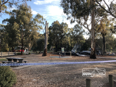
Photograph, Vicki Ward, Day breaks over the destroyed Adventure Playground at Eltham North, 16 December 2017
A community group project steered by Bambi McLean led to the construction of the Eltham North Adventure Playground which opened off Wattletree Road in 1995. The structure was mainly wooden and included an undercover element with slides and areas to climb. It was destroyed by fire in the early hours of 16 December 2017. These phtoos of the aftermath were taken at approx. 6:45am in the morning by Vicki Ward, MP for Eltham A new adventure playground was built in 2018. Digital fileeltham north, north eltham adventure playground, arson, wattletree road -
 Lakes Entrance Historical Society
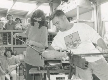
Photograph - Woodsedge Craft Centre Baades Road Lakes Entrance Victoria, Lakes Post Newspaper, 7/05/1995 12:00:00 AM
glass blower Tricia Allen with Michael Hook of Melbourne working on demo vase at Woodsedge Craft Centre Baades Road Lakes Entrance VictoriaBlack and white photograph of glass blower Tricia Allen with Michael Hook of Melbourne working on demo vase at Woodsedge Craft Centre Baades Road Lakes Entrance Victoriaarts, businesses, people, arts and crafts -
 Marysville & District Historical Society
Photograph (item) - Black and white photograph, Rose Stereograph Company, Nichol's Lookout, Marysville, 1913-1967
An early black and white photograph of the view from Nichol's Lookout which is on the Marysville-Wood's Point Road near Marysville, Victoria.An early black and white photograph of the view from Nichol's Lookout which is on the Marysville-Wood's Point Road near Marysville, Victoria. The photograph was also used to produce the Rose Series postcard P. 2324.marysville, victoria, photograph, nichol's lookout, marysville-wood's point road, p. 2324, rose series postcard, souvenir, rose stereograph company, wood's point, mining, yarra track -
Whitehorse Historical Society Inc.
Map, Subdivision Plan for part of Blackburn Park, c1910
Photocopy of advertisement for sale of subdivision of area in BlackburnPhotocopy of advertisement for sale of subdivision of area in Blackburn between the railway line and Whitehorse Road between Station Street and Alfred Street. Some purchasers noted between 1903 - 1912.Photocopy of advertisement for sale of subdivision of area in Blackburnland subdivision, whitehorse road, blackburn, station street, blackburn, railway road, blackburn, queen street, blackburn, albert street, blackburn, chapel street, blackburn, george street, blackburn, cottage street, blackburn, alfred street, blackburn -
Whitehorse Historical Society Inc.
Article, Pledge on Freeway, 29/09/1992 12:00:00 AM
Article in Nunawading Gazette 29 September 1992.Article in Nunawading Gazette 29 September 1992 in which the Opposition spokesman for roads and ports, Mr Bill Baxter reaffirmed his party's commitment to build the Eastern Arterial Freeway.Article in Nunawading Gazette 29 September 1992.roads and streets, eastern freeway, baxter, bill -
 Wodonga & District Historical Society Inc
Photograph - Terminus Hotel, Wodonga, C. 1906
The Terminus Hotel, Wodonga was built by James Thompson Hatch in 1873, the same year the railway reached Wodonga from Melbourne. It was named due to its close proximity to the railway terminus. It was sold to Messrs George Day and Kenneth McLennan of Albury. It was first licenced to J.G. Morton in January 1874. Annie Allen, from Ireland, took over as licensee of the hotel containing 14 rooms in 1879, after she and her husband, George James Allen, purchased it. In 1887 they added a new wing on the south boundary of the property next to Peter McLean’s store at 81 Sydney Road. The architects for the new wing were Gordon and Gordon. A billiard room, a dining room, and 18 other rooms were added on the vacant block of land between the Hotel and the Bank of Victoria. A balcony 6 feet wide was added on the north side. Included in the plans was the latest patent elevator, later known as a dumb waiter. Allen died in 1889 aged 52, and Annie Allen continued to run the Terminus. She later married John G. Haldon and was licensee of the hotel until December 1898 when the licence was transferred to William Carkeek. Carkeek, from Cornwall, arrived in the colony around 1860 and is considered one of the founders of Tallangatta. In November 1903, the license was transferred to Daniel Crawford, then in 1906 it was transferred to Mr Stephen Carkeek. In 1916 it passed into the hands of Mr H. W. Allen of Rutherglen, son of Mr George James Allen. Between 1916 and 1933 there were a variety of licensees. In October 1933, the stables and garage at the rear of the Terminus Hotel were totally destroyed by fire. In 1935, the Terminus again underwent a series of improvements and extensions at the cost of £3,000. The front of the premises was extended in the fashionable Spanish mission style. The balcony of brick and concrete was extended to be 18 feet wide, wire gauged and fitted with glass slides and a tile roof. In addition to 15 new bedrooms, four more bathrooms, making seven in all, were available for patrons. These were on the second floor, while beneath them provision was made for four shops and a new kitchen and a laundry. Throughout the 1930s and 1990s the licensee and owners changed several times. On 1st June 1998 the Terminus Hotel was destroyed by fire. Estimates of damage range from between a conservative $750,000 to as high as $2 million. The remains of the building were demolished in 1999.The Terminus Hotel was one of the earliest hotels in Wodonga with clear links to the establishment of the railway line. It was an important business and meeting place for social gatherings.Allen's Terminus Hotel in Main Street (known as Sydney Road and later High Street, Wodonga). This image is dated as November 1906, however research suggests the hotel was operated by the Carkeek family and then and also Mr. Daniel Crawford prior to this date. The Terminus was sold by auction on 5th March 1909 as part the estate of Annie Haldon. Annie Allen had married John George Haldon in 1890.Across front of building "ALLENS TERMINUS HOTEL"hotels wodonga, businesses wodonga, terminus hotel wodonga -
 Eltham District Historical Society Inc
Slide, Reconstruction of Grand Boulevard viewed from Panorama Avenue, Montmorency, 18 August 1970, 1970
The Eltham Apex Club conducted a Community Service Project (1965-1968) to raise funds for a new Ambulance Station to service the community. A site bounded by the intersection of Main Road, Grand Boulevard and Looker Road at Montmorency was purchased in 1969. In 1970, Eltham Shire Council undertook roadworks to construct Apex Way in preparation for the new station as well as duplicate Main Road, Lower Plenty, east of Grand Boulevard including the new Lower Plenty Bridge, which had been opened in November 1966, bordering with the City of Heidelberg.35 mm colour positive transparency Mount - Agfacolor Service (Blue)1970-08-18, apex-diamond valley ambulance station, eltham ambulance station, eltham apex club, grand boulevard, montmorency -
 Kiewa Valley Historical Society
Leaflet - Kiewa, Welcome to Kiewa
The State Electricity Commission of Victoria constructed the Kiewa Hydro Electric Scheme from 1938 to 1961. The Scheme included three power stations, dams, tunnels and was becoming a popular tourist destination with Falls Creek Ski field within its boundaries.This leaflet was published by the SECV to ensure all visitors to the Kiewa Hydro Electric Scheme were made aware of safety measures with regard to their driving and to bush fires. These were necessary as the area was unique with driving on mountainous roads, changeable and extreme weather and the threat of bush fires. The gatehouse existed during construction, when the SECV was in charge, as a restriction to entry to the Scheme for SECV workers and those with permission to enter. The SECV controlled the area so in case of accident, the SECV was the body to contact not eg. the police.Small white and green leaflet made from one sheet of glossy paper and folded in half. Front cover has the title in the middle, the SECV emblem at the centre top and across the bottom is a message to read the inside pages which are safety messages for driving and bush fires. The back cover has a RACV road map of Kiewa and its 'works' including the Gatehouse which was the entrance to the scheme.The map also has an insert of the main roads & nearby cities. state electricity commission of victoria; kiewa hydro electric scheme; gatehouse; safety rules; kiewa -
Southern Sherbrooke Historical Society Inc.
Information folder - Belgrave Heights Convention Ground
Information folder containing items pertaining to the history of the Belgrave Heights Convention Grounds. Contents: -map, "Belgrave District Road Map" showing locations in Belgrave Heights & South -map "Belgrave Heights Road Map" showing Convention Grounds, buildings and other local sites -Various items photocopied on single sheet, inc. token for Gospel Supplies, Belgrave Heights; item re. Rudi Atwood, minister; list of hymns; photo of Main St, Belgrave. -
 Whitehorse Historical Society Inc.
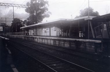
Photograph, Nunawading Railway Station, 1/06/2009 12:00:00 AM
One of a collection of photographs taken of the Nunawading Railway Station prior to the lowering of the railway line and building of the new railway station on the western side of Springvale Road so that the Springvale Road Rail Crossing can be eliminated.Black & white photograph of he precinct surrounding the Nunawading Station and the Springvale Road Railway crossing. This photograph is A close up of the southern entrance to the Nunawading Station from Station Street. See NP 3545 to NP3567for the complete set of photographsnunawading railway station, springvale road nunawading, station street nunawading -
 Whitehorse Historical Society Inc.
Photograph, Station seen from north side-Platform, 1/06/2009
One of a collection of photographs taken of the Nunawading Railway Station prior to the lowering of the railway line and building of the new railway station on the western side of Springvale Road so that the Springvale Road Rail Crossing can be eliminated.Black & white photograph of he precinct surrounding the Nunawading Station and the Springvale Road Railway crossing. This photograph is a close up view of the south platform at Nunawading from the north side.|See NP 3545 to NP3567for the complete set of photographsnunawading railway station, springvale road nunawading, redevelopment of railway line/springvale road. -
 Eltham District Historical Society Inc
Photograph, Peter Pidgeon, Graves of William J and Mary Jane (nee Vance) Crozier and their sons Thomas Vance and John McClelland Crozier, Eltham Cemetery, Victoria, 5 April 2021
William Crozier was born 1823 in County Armagh, Ireland. Mary Jane Vance was born 1829 in Desecrete, County Tyrone, Ireland. They were married in 1848. On New Year's Eve, 1849, together with their baby daughter Sarah, William and Mary embarked from Plymouth aboard the Eliza Caroline, as assisted immigrants, for Port Phillip, arriving 31 March 1850 from where they journeyed out to Eltham on a bullock wagon. The Croziers were Episcopalians and soon after arriving in Eltham the Wesleyans of Little Eltham were holding services in the Crozier's home, among other locations. It was not until January 1856 that the Wesleyan church first acquired land in Henry Street for a chapel, which later became the home of the Eltham Hall. The Crozier home, known as ‘Belmont’ was weatherboard with a rammed earth floor. It was situated on twenty-four acres along the track at its rise, about half-a-mile east of Maria Street (Main Road) bounded by Mt Pleasant Road on the south and Pitt Street northwards. William Crozier used the land for cultivation and grazing. The track the Eltham Wesleyans took, by foot or horse, was along the Mt Pleasant Road, and like most roads of the time, a dusty trail in summer and a hoof and cart rutted quagmire in winter. William and Mary Crozier had seven children: Sarah, (1848 Ireland), John McClelland (1851 Eltham), Eliza (1855 Eltham), William (1857 Eltham), Jane(1859 Yarraville), Charlotte Amelia (1861 Yarraville), and Thomas Vance (1864 Eltham). The Crozier farm prospered and in 1870, William applied for, and was granted a leasehold on an additional sixty-three-acre selection, half-a-mile east of his twenty-four-acre Mt Pleasant Road property. Upon this property he built a two-roomed dwelling of slats and bark and a storeroom of log and bark, ten feet square. In 1880 he applied for a Crown grant of the property. Tragedy struck the family in 1882 when the youngest, Thomas Vance at age 17 accompanied by John Anderson, went into "Hall's Dam" to bathe, neither of them being able to swim. On wading out together, Crozier suddenly slipped into a part about 10ft. deep, and sank, after rising only once. Anderson pluckily tried to save him, nearly losing his own life in the attempt, saving himself when sinking for the last time by seizing hold of a projecting root. The body was not recovered until two hours after, when Mr. Thomas Bell, a farmer in the locality, who was attracted to the spot, on hearing of the occurrence, although unable to swim, plunged in with a rope around his waist, and succeeded with some difficulty in bringing it to the surface. Their eldest son, John also died prematurely at age 42 when he was killed by a falling tree branch whilst engaged in ring-barking trees at Eltham. A still cold wind was blowing and John, and others who were working with him, sheltered themselves at lunch time by sitting on the side of a large tree. When thus seated, the wind detached a limb of the tree which sheltered them, and though they heard the cracking, they had not time to get clear before the limb fell. It struck John on the head, and felled him to the ground, He appeared to be suffering severe pain, and two of his companions conveyed him to the Melbourne Hospital, where during the night he was operated upon for a fracture of the skull. Despite the operation being successful, John ultimately succumbed to his injuries the following afternoon. In good times William was known for his wealth of reminiscences of the early days of the district however his health failed him for several years until his death in March 1909. He was a man of very industrious habits, of a retiring disposition and much esteemed by those who knew him best. Mary died in January 1915 after a long illness. They are buried together along with their sons John and Thomas in the Eltham Cemetery. In Loving Remembrance William Beloved husband of Mary Jane Crozier Who departed this life March 31st 1909, aged 85 years Also Mary Jane Beloved wife of the above Who departed this life January 3rd 1915, aged 86 years Also John McCelland Son of the above Who departed this life May 20th 1894, aged 42 years also Sacred Memory of Thomas Vance Dearly beloved son of William J. Crozier Who departed this life at Eltham, February 3rd 1882 Aged 17 yearsBorn Digitaleltham cemetery, gravestones, john mccelland crozier, mary jane crozier (nee vance), thomas vance crozier, william j crozier -
 Bendigo Military Museum
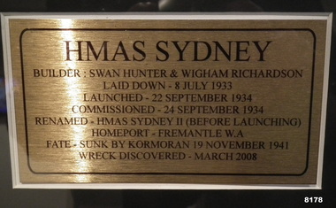
Photograph - PHOTOGRAPH, FRAMED, Unknown
As per the explanation the HMAS Sydney II was launched in Sept 1934, sunk by the German Raider Kormoran on 19 November 1941, the wreck was discovered in March 2008. This item is on display inn the Bistro area of the Bendigo DRSL in Havilah RoadPhotos framed, the frame is timber Brown colour, at the top is the main photo of the ships crew on the decking of the HMAS Sydney II, centre is an explanation of the “Sydney’s building, commissioning and fate, at bottom LH side shows the “Sydney” at sea, the RH photo shows “Sydney” in front of the Sydney Harbour Bridge“HMAS SYDNEY”brsl, smirsl, bdrslinc -
 Kiewa Valley Historical Society
Maps - Tawonga and Feathertop
Plan of Tawonga showing roads etc, rivers, use of land in 1968 and of Feathertop in 1969.Historical use of land in Tawonga and Feathertop.1. Topographical Map - Tawonga 803 Forests Commission of Victoria 1968. Cream paper with black print. Legend: Roads, tracks etc, rivers, Parishes and use of land. 2. Feathertop 813. 1969tawonga map 1968, tawonga parishes, feathertop map 1969 -
 Lakes Entrance Historical Society
Photograph - Princes Highway Lakes Entrance, 1990 c
One other photograph showing vegetation taken from the left hand side of road.Colour photograph taken from the Princes Highway, showing the last bend in the road before the northern approach to the concrete North Arm Bridge, shows the North Arm and waterfront in distance. Lakes Entrance Victoria bridges, roads and streets, township -
 Kew Historical Society Inc
Photograph - The Boulevard at Kew, 1937
The Yarra Scenic Boulevard stretching from Hawthorn to the Chandler Highway was completed as a major project between 1933 and 1936 during a period of significant unemployment. Key dates in the construction this section the road include: 1933 when Kew Council supported the construction of the road from Studley Park to the Kew Asylum; and 1936 when the road from the Johnston Street Bridge to the Chandler Highway was opened. The inscription on the reverse of the photo 'Boulevard Fairfield' is misleading as there is no section of the Boulevard in Fairfield. A more likely interpretation is that it is a photograph of the Kew section of the Yarra Boulevard with the factories of Fairfield in the distance.Rare early photograph of the Yarra Boulevard, taken one year after the opening of the road. The photograph is an important historical record of the results of 'Susso' labor in the creation of major works in Melbourne by the Victorian Government. Original, black and white positive print of the Boulevard at Kew in 1937. Key aspects to note about the photograph is that the road is bituminised; that the gutters are concreted; that the kerb is constructed of concrete blocks; and that there is an unmade footpath on what appears to be the right hand side of the road. The landscape is sparsely treed, and those trees that remain are presumably remnant vegetation. At the right, the land is fenced. The land at the left falls away sharply to the river below. On the horizon, at left, there is an industrial complex including a tall chimney that is burning fuel creating smoke. "Boulevard Fairfield" great depression, susso projects, roads -- kew (vic.), yarra boulevard, yarra valley -
 National Vietnam Veterans Museum (NVVM)
Award, Unit Citation
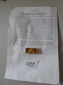
Unit citation awarded to 8th Batt RAR for search and destroy operations in Phuoc Tuy province. The Battalion were able to destroy the secret zone of Viet Cong main force units causing heavy casualties so population could live safely also help to rebuild roads, bridges, markets, and schoolsvietnamese cross of gallantry -
 Kew Historical Society Inc
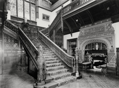
Photograph - Staircase of 'Tara Hall', Studley Park Road, Marc Strizic (attrib), c.1960
'Lost Glories: a memorial to forgotten Australian buildings' was published by David Latta in 1986. It tells the story of a number of significant Australian buildings that had previously been demolished. A chapter in the book was devoted to Goathland, later known as Tara Hall. To supplement the text, he sourced photographs from a range of suppliers, chiefly the Royal Women's Hospital which had once owned Tara Hall, but had sold it in 1960. This is one of the photographs donated to KHS by the author. The Staircase at Tara Hall, circa 1957. An angled view of the main hallway and staircase of Tara Hall (previously named Byram, Goathland and Lowan). To the right of the staircase in this Studley Park Road mansion, a large inglenook fireplace was located, which was surrounded by stucco decoration. The latter was a characteristic of E. G. Kilburn’s late style.Typed inscription on reverse: "The Staircase at Tara Hall. Above the ornate fireplace is the legend 'Come When You Mind, A Welcome Find'. (Royal Women's Hospital, Melbourne)." byram, goathland, tara hall, lowan, studley park (kew), george ramsden, sir malcolm mceacharn, edward george kilburn (architect), studley park road (kew) -
 National Wool Museum
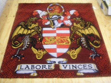
Rug
The rug hung in the boardroom at the Brintons Carpet premises/factory at Fellmongers Road, Breakwater. Acquired on closure of factory.W7199 Page 1 of a history of Brintons Carpets. Page 2 of a history of Brintons Carpets. A list of catalogues/items in the Brintons Collection donated after closure of Fellmongers Road factory in July 2008.Labore Vinces Brintons Carpets/Special Enquiry Prepared for/Ref. No 15/2878 for Aurora/Quality colours in trial/standard/non standard/Design and colour sample does not represent qualitytextile art, brintons australia pty ltd brintons pty ltd (geelong) brintons ltd (uk), carpet -
 National Wool Museum
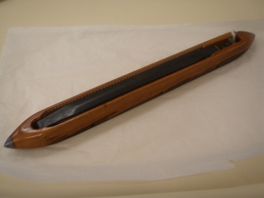
Shuttle
Used at Brintons Carpets Fellmongers Road factory. Acquired on closure of factory. (Used for Brintons Wilton Loom?)W7210 Page 1 of a history of Brintons Carpets. Page 2 of a history of Brintons Carpets. A list of catalogues/items in the Brintons Collection donated after closure of Fellmongers Road factory in July 2008.Made in England Ramsey McDonald Pty.Ltd. Melbourne 6/83 28textile machinery textile industry textile mills weaving weaving mills, brintons australia pty ltd brintons pty ltd (geelong), geelong, victoria, textile machinery, textile industry, textile mills, weaving, weaving mills -
Clunes Museum
Map - MAPS
ORIGINAL MAP SHIRE OF TALBOT AND CLUNES. LOCALITY PLAN, SEALED ROADS, BITUMEN ROADS, GRAVEL OR SAND ROADS, UNMADE OR PART FORMED ROADS.local history, document, maps, talbot, clunes shire -
Glen Eira Historical Society
Document - St. Stephen’s Presbyterian Church, Caulfield
Two A4 pages handwritten notes dated 23/08/2002, written by Keith Stodden regarding the Caulfield Indonesian Uniting Church, 158 Balaclava Road Caulfield North, formerly St. Stephen’s Church. Details very briefly the closure and re-opening of the church in 2001. Also included is an order of service for a service on 18/08/2012 which combined with Elsternwick Uniting Church that week to worship together. The program is written in Indonesian.stodden keith, porter ian rev. dr., caulfield, balaclava road, elsternwick, caulfield north, uniting church, presbyterian church, caulfield indonesian uniting church, st. john’s presbyterian church, elsternwick uniting church, st. stephen’s uniting church, st. stephen’s presbyterian church, religious ceremonies, religious groups, stained glass, events and activities, programs, religious structures an d establishments, languages, ethnic communities, indonesian community -
Glen Eira Historical Society
Letter - Uniting Church Archives, Orrong Road, 78-66, Elsternwick
Two Documents about the Merklin-Schutze organ. Correspondence from the National Trust Victoria to the city of Caulfield, advising that the Uniting Church, 66 Orrong Road, Elsternwick Merklin-Schutze Organ has been included in the National Trusts register dated 11/10/1990. Photocopied document, date unknown, stating that the organ has been gifted to the Australian Catholic University and will be restored and installed in the University’s Central Hall Brunswick Street, Fitzroy.merklin-schutze organ, organs, uniting church, orrong road, elsternwick, nation trust, brussels, st. john’s anglican church, toorak, caulfield, australian catholic university, halls, university central hall, brunswick street, fitzroy, elsternwick south church, caulfield south church -
Glen Eira Historical Society
Article - Shoobra Road, 53, Elsternwick, 'Linbrae'
Three articles on 53 Shoobra Road: Melbourne Weekly Bayside magazine auction features dated 06/10/2010 and 20/10/2010 giving brief details of interior features and external extras. Articles include four and seven photographs respectively of house interior and exterior. Handwritten research by Claire Barton taken from Sands and MacDougalls editions 1910, 1913, 1923, 1942, 1948 and 1960 dated 30/09/2011.shoobra road, elsternwick, 'linbrae', biggin scott, williams kharla, stavrakis bill, architectural features, architectural styles, cast iron work, real estate agents, bryant samuel rev., bay windows, hestia, house names, appleton bv miss, victorian style, marble, fireplaces