Showing 12221 items matching " reserves"
-
 Bendigo Military Museum
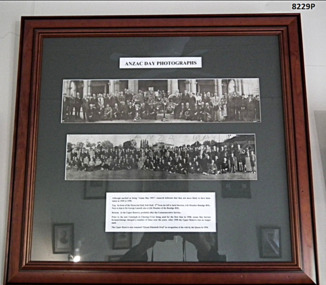
Photograph - ANZAC DAYS, FRAMED
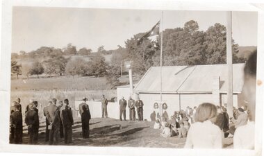
In the top photo there are only a couple who are identifiable, 3rd from the left is Jack Swatton, (refer Cat No 6719.2P), 4th from left is George Lansell, (refer Cat No 8012P), there is one other from the left being possibly Les Morey The same Les Morey is in the bottom photo 8th from the left. These images are a copy of of the originals which were joined together and laminated as one. They were not taken the same year. Just by appearance the top photo is a number of years earlier than the bottom. There is an original of the top photo still in its cardboard cylinder for postage. Refer Cat No 8238.2TWO PHOTOGRAPHS WITHIN ONE FRAME. Anzac Day photos in black and white. Top Photograph - In front of Memorial Hall, Pall Mall (1949/1950) Lower Photograph - At the Upper Reserve (later renamed Queen Elizabeth Oval) At the bottom is a description. Frame- timber, mid brown colour with decorative edge. Glass front, Mount - dark green cardboard.On photos in the centre hand written is “Anzac Day 1951”brsl, smirsl, anzac day framed photos -
 Phillip Island and District Historical Society Inc.
Tickets, 1972
Unused ticket for the Phillip Island Auto Racing Club meeting on the 30th January, 1972. Phillip Island Auto Racing Club's Lady's Pass to the 30th January 1972 Race Day.Phillip Island Auto Racing Club.......Lady's Pass 30th January, 1972.......Paddock and Members' Reserve.........Admit One Only..... Sunday, 30th January, 1972 and Saturday 29th January 1972. On back "Motor Racing is Dangerous".......with conditions following.auto racing ticket, bruce procter -
 St Kilda Historical Society
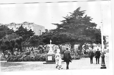
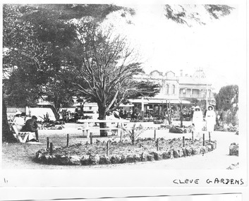
Photograph, Cleve Gardens, c. 1915-1916
St Kilda, c. 1915-1916black and white photograph, unmountedCleve Gardens c/r Fitzroy St & Beaconsfield Pde. Handwritten on back Melbourne - Suburbs - St Kilda. The Cleve Reserve corner of Fitzroy Street and Beaconsfield Parade. St Kilda by the Sea p32 �Stamped National Library of Australia Canberra -
 Thompson's Foundry Band Inc. (Castlemaine)
Document - Sheet Music for Brass Band, We are the Boys from Way Down Under - Song March, 1940
Played and sung by the ANZACS on their arrival in England (WWII)18 Parts for Brass Band, 2nd Trombone part is missing.Copyright 1940 in U.S.A. by Boosey & Co Ltd. Copyright in all countries All rights reserved Sole Selling Agents: BOOSEY & HAWKES (AUST.) PTY. LTD., 250 Pitt Street, Sydney. Tous droits reserves B & H 8409anzac, j.e.pyke, new zealand, t. conway brown, boosey and hawkes, war songs, marching songs, australia, songs, patriotic music, wwii, world war 2, 1939-1945, army -
 Orbost & District Historical Society
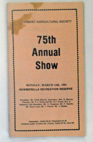
book, 75th Annual Show, prior to March 1984
This magazine was produced as a program for the 75th Annual Show at Newmerella Recreation Reserve. The first meeting to form an Agricultural society in Orbost was convened by the then Orbost Progress Association and held in the Mechanics Hall on Saturday, 10th October 1891. Its first show was held on 3rd March 1904...on a site alongside the Bonang Road where the present Golf Club stands. It is currently held at the Recreation Reserve at Newmerella. Ref: In Times Gone By-Deborah HallThis item is associated with the Orbost Agricultural Society 's Annual Show which has been a major event in Orbost for over a century. Agricultural shows are an important part of cultural life in small country towns and the Orbost Show is an integral part of Orbost 's agricultural history. A small thin 40 pp paper booklet with a buff coloured cover. On the cover is the title, "75th Annual Show in black print. It is inside a black border with "Orbost Agricultural Show" at the top. There is the date of the event, details of the committee members and costs of admission beneath the title.orbost-annual-show -
![Sign, Regulations for the Care, Protection and Management of the " Penguin Reserve" at Phillip Island [ As amended ] 1956 and 1968, 1956 and 1968](/media/collectors/4f729f5b97f83e0308601629/items/6476aa1f1e1a2671cef44090/item-media/6476ab3b1e1a2671cef4be40/item-fit-380x285.jpg) Phillip Island and District Historical Society Inc.
Phillip Island and District Historical Society Inc.Sign, Regulations for the Care, Protection and Management of the " Penguin Reserve" at Phillip Island [ As amended ] 1956 and 1968, 1956 and 1968
Board of Land and Works reserved land on Phillip Island by Orders in Council in December 1955 and June 1956 as sites for a penguin rookery and known as the Penguin Reserve.HistoricalLarge cream cloth sign with black print outlining regulationswildlife - penguins, penguin reserve, phillip island nature park, signs -
Port Melbourne Historical & Preservation Society
Archive, Port People Archive, 2008 - 2019
Official records of port People Inc. Port people were an activist group formed because of concerns over Council intentions for Garden City reserve.Port People Archive six folders .01 - pink binder marked Port People minutes (hand written) January 2008 -April 2012 Attached sheet has detailed contents of folders and also on USB stick. Supplementary file has a list of significant issues contained in the dicuments as considered by Rowan Groves, President.built environment, local government - city of port phillip, parks and gardens, public action campaigns, port people inc, rowan groves - president, garden city, garden city reserve -
Port Melbourne Historical & Preservation Society
Archive, Port People Archive, 2008 - 2019
Official records of port People Inc. Port people were an activist group formed because of concerns over Council intentions for Garden City reserve.Port People Archive six folders .02 - black cover 2 ring binder. PPI minutes May 2010 to December 2012 Also: agenda file 2010 to 2015; Correspondence file 2012-2013; Financial file 2000 to 2018; CD ROM disk marked Port People files; Leaflet "Who are Port People?"; PPI code of conduct Attached sheet has detailed contents of folders and also on USB stick. Supplementary file has a list of significant issues contained in the dicuments as considered by Rowan Groves, President.built environment, local government - city of port phillip, parks and gardens, public action campaigns, port people inc, rowan groves - president, garden city, garden city reserve -
Port Melbourne Historical & Preservation Society
Archive, Port People Archive, 2008 - 2019
Official records of port People Inc. Port people were an activist group formed because of concerns over Council intentions for Garden City reserve.Port People Archive six folders .03 black cover PPI, Port people on spine Minutes 2013 - 2016; AGM minutes 2007 - 2019; Celebrations in the Park miknutes ; Membership lists 2009 -2015; invoices Attached sheet has detailed contents of folders and also on USB stick. Supplementary file has a list of significant issues contained in the dicuments as considered by Rowan Groves, President.built environment, local government - city of port phillip, parks and gardens, public action campaigns, port people inc, rowan groves - president, garden city, garden city reserve -
Port Melbourne Historical & Preservation Society
Archive, Port People Archive, 2008 - 2019
Official records of port People Inc. Port people were an activist group formed because of concerns over Council intentions for Garden City reserve.Port People Archive six folders .04 - whiote cover Port people on spine. Westpac bank statements and letters 2008-2019 Attached sheet has detailed contents of folders and also on USB stick. Supplementary file has a list of significant issues contained in the dicuments as considered by Rowan Groves, President.built environment, local government - city of port phillip, parks and gardens, public action campaigns, port people inc, rowan groves - president, garden city, garden city reserve -
Port Melbourne Historical & Preservation Society
Archive, Port People Archive, 2008 - 2019
Official records of port People Inc. Port people were an activist group formed because of concerns over Council intentions for Garden City reserve.Port People Archive six folders .06 - black cover Port people on spine. Correspondence; leaflets; registration doamin .au name; documents from other bodies including COPP; Attached sheet has detailed contents of folders and also on USB stick. Supplementary file has a list of significant issues contained in the dicuments as considered by Rowan Groves, President.built environment, local government - city of port phillip, parks and gardens, public action campaigns, port people inc, rowan groves - president, garden city, garden city reserve -
 The Beechworth Burke Museum Research Collection
Photograph (Series), George Tibbits, William Street, Beechworth, 1976
George Tibbits, University of Melbourne. Faculty of Architecture, Building and Town & Regional PlanningIndex system that support the research for Beechworth : historical reconstruction / [by] George Tibbits ... [et al]Arranged by street names of BeechworthEach index card includes: street name and number of property, image of property, allotment and section number, property owners and dates of ownership, description of the property according to rate records, property floor plan with dimensions.beechworth, george tibbitsbeechworth, george tibbits -
 Linton and District Historical Society Inc
Photograph, Ceremony at RSL Hall, Linton
The RSL Hall was in Clyde Street, Linton, where the Telstra building now stands. The hall was demolished in the 1990s after the opening of the new recreation reserve hall.Small black and white photograph shows a group of hatless men standing to attention at left and a group of mostly children and women seated and standing to right. Four men standing next to the hall in the centre of the photograph appear to be officiating the ceremony. The flag is flying at half-mast. The date of this photograph is unknown, the occasion was possibly an Anzac Day service.In pencil on back: "RSL Hall Ceremony Linton".rsl hall linton, ceremonies -
 Federation University Historical Collection
Plan, Camp Street Ballarat Parish Plan
Camp Street was the site of the original goldfields camp reserve, and it is from here that soldiers and police troopers left to attack the Eureka Stockade on 03 December 1854.PLan of Camp Street Ballaratcamp street, police reserve, old colonists' association, grenville street, lydiard street north, t. cowan, r. surtees, c.m. watson, w.h. foster, j.b. humffray, j.j. goller, h.r. caselli, henry caselli, market reserve, e.v. gribble, old colonists' association of ballarat -
 City of Kingston
Photograph - Black and white, Aerial photograph Highett, 26 March 1956
Part of broad aerial photographic survey of the area. Aerial photograph Highett - Highett Reserve, Sandpits, Gasworks, Nepean Highway, Chesterville Road, Wickham Road.The photograph shows the development of the city of Highett, suburban expansion and industrialisationsquare black and white photographic print on paper, with thick black border; printed text on bottom indicating date and other reference codeshighett, city of moorabbin, aerial photograph, suburbs, highett gas works, recreation, infrastructure -
 Eltham District Historical Society Inc
Photograph, Napier Crescent, Eltham, 1986
Formerly Napier Crescent, now part of current day No. 14 Pederesen Way. on right hand side and looking through into what is now Pedersen Way Reserve 35mm colour positive transparency (1 of 7) Mount - Kodak Kodachrome CardProcess Date JUN 86Meltham, infrastructure, napier crescent, pedersen way, pedersen way reserve, roads -
 Greensborough Historical Society
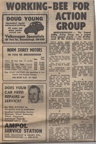
Newspaper Clipping - Digital Image, Working bee for action group, 21/08/1973
A selection of reports on local Greensborough activities. [1973] Includes reports on the development of the De Blonay Crescent Reserve, Greensborough Red Cross, and the aims of Watsonia High School.Digital copy of newspaper article, black text.de blonay crescent reserve, red cross, watsonia high school -
National Wool Museum
Book, Notes on the Australian Wool Board's recommendations for an auction reserve price scheme. 1st October 1964
"Notes on the Australian Wool Board's recommendations for an auction reserve price scheme. 1st October 1964"- S Ick-Hewins, Graziers' Association of N S WBy S Ick-Hewins, Graziers' Association of NSWwool sales - reserve price plan wool sales wool marketing, australian wool board graziers' association of nsw, wool sales - reserve price plan, wool sales, wool marketing -
 Robin Boyd Foundation
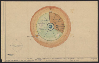
Drawing - Cross section, Tower Hill Lake Reserve Museum, Jun-61
Project: Tower Hill Lake Reserve Museum drawn by Robin Boyd of Grounds, Romberg & Boyd. Drawing no 3 (but different to item PL139). Preliminary cross sectionSketch, Dyeline -
 Robin Boyd Foundation
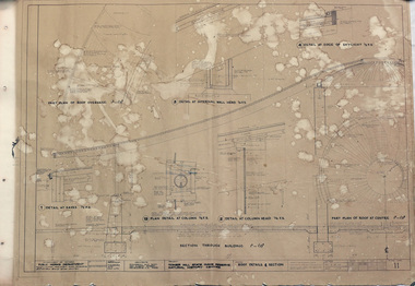
Drawing - Architectural, Tower Hill State Game Reserve Natural History Centre, 5-Oct-62
Project: Tower Hill State Game Reserve Natural History Centre drawn by J.T.W. of Romberg & Boyd for Public Works Department. Drawing no. 11. Section details.Working Drawing, Dyeline -
 The Beechworth Burke Museum Research Collection
Card (Series) - Index Card, George Tibbits, Bridge Street, Beechworth, 1976
George Tibbits, University of Melbourne. Faculty of Architecture, Building and Town & Regional PlanningIndex system that support the research for Beechworth : historical reconstruction / [by] George Tibbits ... [et al]Arranged by street names of BeechworthEach index card includes: street name and number of property, image of property, allotment and section number, property owners and dates of ownership, description of the property according to rate records, property floor plan with dimensions.beechworth, george tibbitsbeechworth, george tibbits -
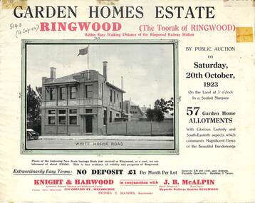 Ringwood and District Historical Society
Flyer, Subdivisional Land Auction Sale Brochure, Garden Homes Estate, Ringwood, Vic. - 1923
Double sided multi-folded page advertising auction sale of residential allotments highlighting local facilities, services and layout of the estate. Includes panoramic view of Ringwood and other local photographic images.Subdivision includes Mullum Mullum Road, The Centreway, Wattle Crescent and Reserve Crescent. Agents - Knight & Harwood, 315 Collins Street, Melbourne, Phone 10615, 10616 Central, in conjunction with J.B. McAlpin, Opposite Railway Station, Ringwood. Phone Ringwood 7. -
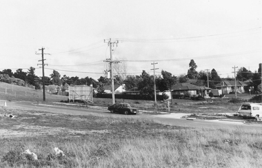 Ringwood and District Historical Society
Photograph, South-western view from Marcel Street North Ringwood over Jull Parade to Oban Road - 1981. North Ringwood Sports Reserve is on the left, above the corner of Jull and Oban Roads
Writing on back of photograph reads, "E620. N1. 1981. Looking south-west from Marcel Street North Ringwood over Jull Road to Oban Road. North Ringwood Sports Reserve centre left above corner of Jull and Oban Roads". -
 St Kilda Historical Society
Photograph, Cleve Gardens, c. 1915-1916
St Kilda, c. 1915-1916black and white photograph, unmountedCleve Gardens c/r Fitzroy St & Beaconsfild Pde. Handwritten on back Melbourne - Suburbs - St Kilda. The Cleve Reserve corner of Fitzroy Street and Beaconsfield Parade. St Kilda by the Sea Annual p35 �Stamped National Library of Australia Canberra -
 City of Greater Bendigo - Civic Collection
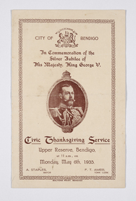
Programme - Event program for the 1935 Silver Jubilee celebrations of His Majesty, King George V, Boltons, Civic Thanksgiving Service, c 1935
Born in 1865, The Prince of Wales was proclaimed King George V following his father's death on 6 May 1910, and his Coronation took place at Westminster Abbey on 22 June 1911. As the second son of King Edward VII, George V was not next in line to inherit the throne—until his elder brother’s death in 1892. He succeeded his father in 1910 and was crowned in 1911, just over three years before the United Kingdom would enter World War I. At home, he was confronted with a divided Parliament, industrial unrest, and the task of replacing a resigning prime minister .In 1935, the King celebrated his Silver Jubilee. This event was celebrated throughout Australia and the City of Bendigo event was typical of such events. The King did not attend. He died on 20 January 1936.Folded, single colour, printed brochure outlining the days proceedings for the visit. Front cover depicts image of George V and time and date of event. Inside describes the Order of Service including an Address by Mayor Staples and various hymn and prayer readings. ft: City of Bendigo / In Commemoration of the / Silver Jubilee of / His Majesty, King George V. fl; Civic Thanksgiving Service / Upper Reserve, Bendigo, / at 11am, on / Monday, May 6th, 1935. ll; A. Staples, / Mayor. lr; F.T. Amer, / town Clerkmayor staples, upper reserve, city of greater bendigo royal visits -
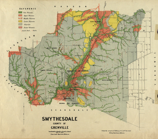 Federation University Historical Collection
Map, Smythesdale, County of Grenville, 1888, 1889
The map maker, Ferdinand M. Krause, was a professor at the Ballarat School of Mines. This land was printed form the Crown Lands Department, Melbourne. Coloured map of the County of Grenville. The edge has been taped. The scale is 40 chains to 1 inch. The map is accompanied with a foolscap sheet printed by the Mines Department in 1898. It is a Report on the Parish of Smythesdale by F.M. Krause and includes information on the water reserve, worked quartz veins, Watson's Hill, Surface Hill and Sugarloaf Hill, Haddon, Trunk Lead and the Crucible Shaft. smythesdale, krause, f.m. krause, ferdinand krause, nitingbool, watson's hill, surface hill, sugarloaf hill, haddon -
 Bendigo Historical Society Inc.
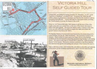
Document - VICTORIA HILL SELF GUIDED TOUR 2014
Two page document prepared for the 2014 centenary of the mine disaster at the Great Extended Hustlers Mine, where 7 miners were killed in 1914. Document titled 'Victoria Hill, Self Guided Tour' prepared by Philip Wilkin and Kay MacGregor (Windlass Production 2014) The guided tour document was made available at the commemorative event held at the Hustler's Hill Reserve.bendigo, mining, victoria hill guided tour -
 Bendigo Historical Society Inc.
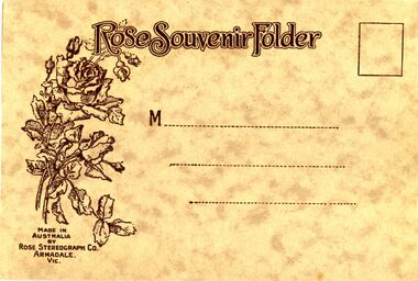
Photograph - BENDIGO PHOTO FOLDER, 1920's
Rose souvenir folder containing fourteen black & white photographs Of Bendigo buildings and scenes. Pall Mall & PostOffice, Upper Reserve showing Municapal Baths, Memorial Hall & Po, Mitchell Street, The Conservatory, Lake Weeroona showing Boat houses, Pall Mall, Soldiers Memorial, Queens Gardens, Shamrock Corner, Rosalind Park, The Fernery, Pall Mall , Alexandra Fountain.Rose Stereograph Co, Armadale Vicbendigo, buildings, heritage buildings -
 Bendigo Historical Society Inc.
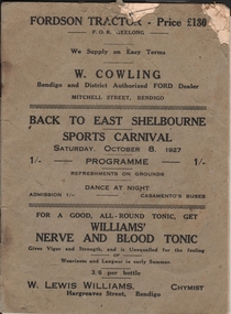
Document - JOAN LEVERSHA COLLECTION: BACK TO EAST SHELBOURNE PROGRAM 1927
Small booklet (20 pages) for the "Back to east Shelbourne" Sports Carnival. Saturday, October 8, 1927. The first two pages record the names of the Executive Committee and the Officials. The next eight pages record the history of East Shelbourne, followed by eight pages listing the events that will occurred during the carnival. The booklet end with two pages describing the East Shelbourne Recreation Reserve.event, back to, east shelbourne -
 Bendigo Historical Society Inc.
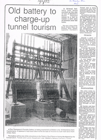
Newspaper - LONG GULLY HISTORY GROUP COLLECTION: 10 HEAD BATTERY
Copy of a newspaper article titled Old battery to charge-up tunnel tourism. Date written on the paper is 11/1/85. The Thompson's Foundry Battery was re-erected in the Parkin's Reef Reserve after being used at Bola Creek near the NSW border. A team of volunteers and a Grant had it moved to Maldon where it was set up and the area made attractive for tourists.bendigo, history, long gully history group, the long gully history group - 10 head battery, thompson's foundry battery, parkin's reef reserve, conservation forests and lands department, carman's tunnel, north british mine, parkins reef, carman's tunnel committee, dr doug kemsley, prospectors' and miners' association of victoria, mr ken garden