Showing 2476 items matching " township"
-
 Greensborough Historical Society
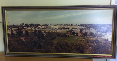
Photograph (Framed), Greensborough in December 1978, 1978_12
Photograph three in a series of three panoramic photographs of Greensborough before and after the construction of Greensborough Plaza at the end of the 1970s. Shows the changing landscape of Greensborough from rural to suburban township.These photographs clearly show the change in the street scape of Greensborough from the Hailes Street/Circuit side of townPanorama photograph in timber frame. One of three in series. Labelled in red on front of frame 'Greensborough December 1978'greensborough, greensborough plaza -
 Greensborough Historical Society
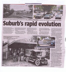
Newspaper Clipping, Diamond Valley Leader, Suburb's rapid evolution, 12/04/2017
Eltham was described as a blossoming township and featured in the top 10 fastest growing Victorian suburbs during the 1960s. This article looks at some historic sites in Eltham and how they look today.News article 2 pages, black text, colour image.eltham, changes over times -
 Halls Gap & Grampians Historical Society
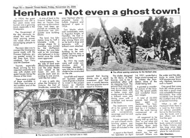
Newspaper - B/W, C 24/11/2000
An article describing the Henham Township project as well as the Knight Family Tearooms built on the Henham site in 1925. For further info see "Victoria's Wonderland" pp 93-95, 103.A newpaper article from "The Stawell Times" , "Halls Gap Extra" Supplement of 24 November 2000, page 16, entitled Henham v- Not even a ghost town!townships, henham -
 Tatura Irrigation & Wartime Camps Museum
Photograph, 1955 Tatura Floods, 2001
In 1955 Ross Street North had to be cut to allow flood waters to relieve the flooding of the Tatura Township. The Midland Highway west of the Tatura Undera Road was cut by flood waters.floods 1955, ross st, midland highway, hogan's farm, baldwin road, photograph, people -
 Phillip Island and District Historical Society Inc.
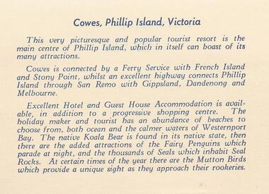
Photograph Folder, approx 1940's - 1950's
Coloured Souvenir folder of 12 postcards donated by M Arnell.Souvenir Colour Folder of 12 colour postcards of Cowes and Phillip Island. Photographs Include: Cowes Beach, Cowes Pier, Koalas, Cowes Township, The Nobbies, Summerland Surf Beach, Suspension Bridge, Thompson Avenue, Cowes, Penguin Parade, Seal Rocks, The Isle of Wight Hotel and The Blowhole.Front cover: A Souvenir of Picturesque Cowes. A Special selection of Scene in Full Colour.phillip island, cowes phillip isand, the isle of wight hotel cowes phillip island, the blowhole phillip island, penguins, koalas, seals, m arnell -
 Learmonth and District Historical Society Inc.
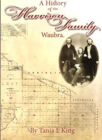
Book, Tania.L.King. et al, A History of the Harrison Family,Waubra,by Tania.L.King, october 2012
This book gives the history of the Harrison Family of Waubra - celebrating 160 years in Australia from 1852-2012.The Harrison family came originaly from Catterick and later Langthorne,North Yorkshire.England.Recording the Family Tree of the Harrison Family of Waubra,Victoria.Cover of book is Beige in colour,with the title and authors name in maroon.On the right under the title is a photo of James Harrison with his two sons William and Christopher .The bottom of the cover shows the title plan of Ercildoun,sheet 2,courtsey State of Victoria.The back cover photograph is of Waubra township.A History of the Harrison Family,Waubra.by Tania.L.King.harrison family 1852 - 2012, waubra victoria, tania l king, catterick north yorkshire england, -
Bendigo Historical Society Inc.
Map - BAMAWM : COUNTY OF BENDIGO, November 1954
Map. Bamawm, County of Bendigo. Sheet 2, Pannoobamawm, Diggorra. Elmore to Cohuna Railway Line. Township of Lockington. By authority W.M. Houston, Government Printer.Drawn and reproduced at the Department of Lands and Survey, Melbourne. November 1954. Price 5/- per sheet. (number 52 in map cupboard 1)W.M. Houston, Government Printermap, bendigo, bamawm -
 Bendigo Historical Society Inc.
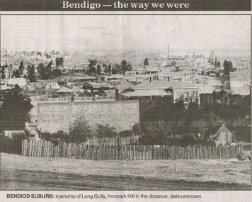
Newspaper - LONG GULLY HISTORY GROUP COLLECTION: BENDIGO - THE WAY WE WERE - LONG GULLY
Black and white photo from Bendigo - the way we were series in the Bendigo Advertiser, November 14, 2000. The photo shows the township of Long Gully, Ironbark Hill in the distance. Date unknown. The photo shows houses, mine chimneys, trees and a rough picket type fence in the foreground.bendigo, history, long gully history group, the long gully history group - bendigo - the way we were - long gully, bendigo advertiser 14/11/2000, ironbark hill -
 Southern Sherbrooke Historical Society Inc.
Postcard - Postcard-original-Swans Bend Belgrave, Vic. c.1940s, A Bend In The Road, Belgrave
Sepia-toned postcard featuring bend coming into Belgrave Township from the west. Later known as Swans Corner. Dr Shirley Francis's house in centre of photo. Photo shows a hillside with three houses above the road. A man walks along the lower side of the road. c. 1920s. -
 Bendigo Historical Society Inc.
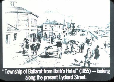
Slide - DIGGERS & MINING: THE DIGGINGS - THE DIGGERS
Diggers & Mining: The Digging - The Diggers. Slide: ''Township of Ballarat from Bath's Hotel'' (1855) - looking along the present Lydiard Street. Shows the hustle and bustle of the towns that have grown from gold. Black and white side. Markings: 41 994.LIF:6. Used as a teaching aid.hanimounteducation, tertiary, goldfields -
Clunes Museum
Map, 1962
.1 &.2 MAP OF BALLARAT SHIRE GROUP RURAL FIRE BRIGADES FIRE CONTROL MAP. COMPILED BY C. H. FENTON. (2 COPIES) DETAILING SEALED ROADS, STATE FORESTS, PINE PLANTATIONS, FOREST AREAS, RAILWAYS, BOUNDARIES, TOWNSHIP AREAS CEMETERIES, CREEKS, SWAMPS AND HOUSES.local history, document, maps, fire brigade -
 Eltham District Historical Society Inc
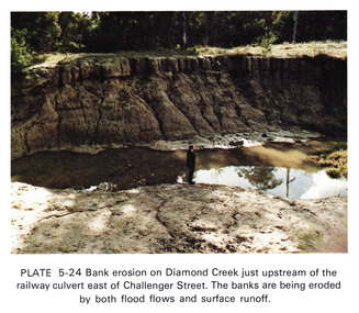
Work on paper (Sub-Item) - Photograph, Bank erosion on Diamond Creek just upstream of the railway culvert east of Challenger Street
Colour photograph of bank erosion on Diamond Creek just upstream of the railway culvert east of Challenger Street in Diamond Creek township. The banks are eroded by both flood flows and surface runoffeltham, drain, diamond creek, erosion, challenger street -
 Greensborough Historical Society
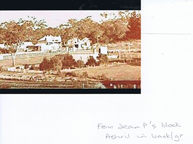
Photograph - Digital Image, Greensborough from Jean Partington's house, 1930s, 1930s
Digital copy of a photograph of Greensborough township from Miss Jean Partington's house in Greensborough (taken from near the present day entrance to Greensborough Plaza from the Circuit, near McDonalds). Digital copy of black and white photographjean partington, greensborough -
 Eltham District Historical Society Inc
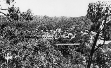
Photograph, View at Warrandyte, Vic, c.1937
View looking southeast across the bridge to Warrandyte township. Taken from the northern side of the Yarra River from near present day 244 Research-Warrandyte Rd, North WarrandyteThis photo forms part of a collection of photographs gathered by the Shire of Eltham for their centenary project book,"Pioneers and Painters: 100 years of the Shire of Eltham" by Alan Marshall (1971). The collection of over 500 images is held in partnership between Eltham District Historical Society and Yarra Plenty Regional Library (Eltham Library) and is now formally known as the 'The Shire of Eltham Pioneers Photograph Collection.' It is significant in being the first community sourced collection representing the places and people of the Shire's first one hundred years.Digital image 4 x 5 inch B&W Negshire of eltham pioneers photograph collection, warrandyte, north warrandyte, warrandyte bridge -
 Lake Bolac & District Historical Society
Colour photograph, Wickliffe Flood, Jan .2011
Wickliffe, the flooded Hopkins River flowing from left to right, both under and over the bridge, showing the inundated Glenelg Highway and township. January, 2011. Photograph courtesy James Davidson.wickliffe, hopkins river, flood, glenelg highway -
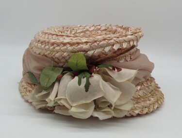 Hume City Civic Collection
Lady's pink straw hat, 1960's
The hat belonged to Edna Vlassopoulos who with her husband Andrew, had a poultry farm and market garden in the old Westmeadows township and later at Bulla. The hat was purchased to wear at a family wedding.A pink straw hat with a pink silk folded band wrapped above a narrow brim. There is a full-blown pink silk rose which is a trim on the RHS of the crown. There is a band of petersham ribbon inside the crown with black hat elastic fastened on either side.clothing and dress, headwear, female, george evans collection -
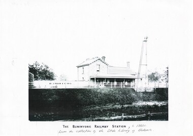 Buninyong & District Historical Society
Print - Black and white copy of Yendon (Buninyong) Station c1860s, The Buninyong Railway Station
Yendon Railway Station, built 1862 as Buninyong (East) Station. Yendon No.1 and No. 2 Roads constructed to connect cab service with the township of Buninyong. The station name was changed to Yendon 1878.This image illustrates The Buninyong Railway Station in the 1860's on the Ballarat to Geelong line, its name was changed to Yendon Railway Station in 1878 and was demolished in 1969A black and white copy of a photograph of Buninyong (Yendon) Railway Station in the 1860sThe Buninyong Railway Station, c 1860s from the collection of the State Library of Victoriabuninyong railway station, yendon (buninyong east) railway station -
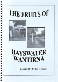 Ringwood and District Historical Society
Book, The Fruits of Bayswater/Wantirna - Compiled by Evelyn Hodgkin - Volume Two, 2002
Compilation of recollections, detailed stories and photographs of residents of Bayswater/Wantirna area, Victoria. Front Cover - (left) Kleinert's Timber Yard, Station Street, Bayswater, 1940s (Photo courtesy Knox Historifcal Society); (right) Mountain Highway - outside Bayswater State School, looking towards township, 1940s. This photo courtesy of Marj Crisp. -
Bendigo Historical Society Inc.
Book - KINGOWER 2006
130 page soft cover booklet 'Kingower 2006' A history of the Kingower Township published by the 'Back to Kingower' Committee in 2006 Compiled by Dona Martin and her father Don Walker Edited by Christine Hancock Illustrated with B&W photos of people and places. Donated by Neil Talbot's family 2018Dona Martin & Don Walker -
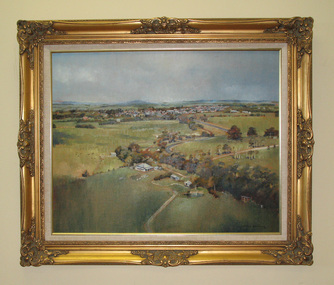 South Gippsland Shire Council
Painting. Oil, Leongatha Landscape
Framed oil painting titled: "Leongatha Landscape" painted by Harris Smith. Features scene of farming property in the foreground and township of Leongatha in the distance. Rolling hills, flora, buildings and sky. Gold decorative frame with cream textured vinyl window mount. Painted in shades of browns, greens, blues and yellows. -
 Southern Sherbrooke Historical Society Inc.
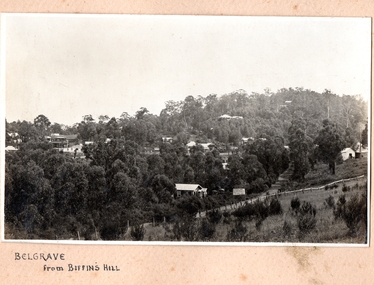
Photograph, Belgrave from Biffin's Hill
Photo of Belgrave township from Biffin's Hill (present-day site of Mater Christi School). Road running across front of photo is now Belgrave-Gembrook Rd. There is a sign on the side of the road advertising Biffin Hill Estate for sale. Belgrave main street is visible in background. c. 1920s -
Bendigo Historical Society Inc.
Booklet - Sebastian Back to & School Centenary March 1-2, 1975, Souvenir Booklet
Yellow, soft cover souvenir booklet, 16 pages. 'Sebastian Back to & School Centenary' March 1-2, 1975 B&W photo of Frederick the Great Mine on front cover. Illustrated with B&W photos including the Sebastian Township about 1865 Printed by 'Express' Print, Wedderburnsebastian, centenary -
 Lakes Entrance Historical Society
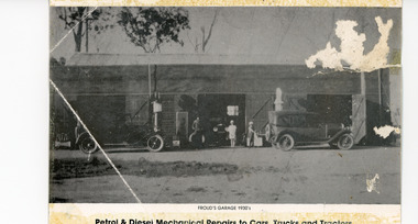
Photograph - Harry Froud's Garage, 1930 c
Appears to have been a promotional postcardBlack and white photograph of Harry (William Henry) Froud's garage situated on Princes Highway in township. Shows two canvas topped motor cars in front of petrol bowsers and another inside the garage, man and girl at doorway, assistant in apron filling petrol tank of one car. Johnsonville VictoriaPetrol and Diesel Mechanical Repairs to Cars, Trucks and Tractorsretail trade, local history, people -
 Eltham District Historical Society Inc
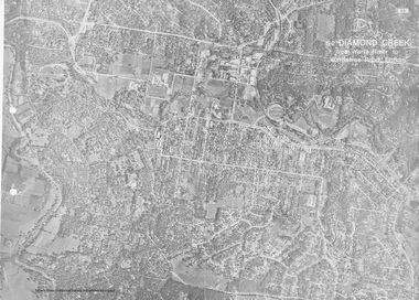
Work on paper (Sub-Item) - Aerial Photograph, Diamond Creek from Yarra River to Wattletree Road, Eltham
Black and white aerial photograph witrh key features around the central place of Eltham township marked inluding Yarra River, Main Road, Bridge Street and Ryans Road, Eltham North land development, real estate, aerial view, eltham, eltham north -
 Wycheproof & District Historical Society Inc.
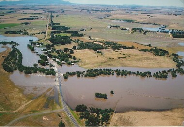
Photograph, Len Storey, Cooroopajerrup Creek 2011, 17/1/2011 (exact)
On Monday January 17th 2011,Wycheproof residents awoke to see the township surrounded by water. Record flooding on the Avoca River had forced the flood water up the semi-mythical Cooroopajerrup Creek. Digital colour photograph of the Cooroorajerrup Creek, depicting the flood-waters of 2011 surrounding Mount Wycheproof. The dwelling in the foreground is the home of Francis and Denise Dillon, barely visible to the left is the Public Hospital.cooroopajerrup creek, mount wycheproof, 2011, flood waters -
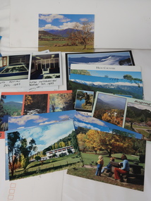 Kiewa Valley Historical Society
Photos, Postcards - Kiewa Valley
Mt Beauty township, at the head of the Kiewa Valley, is situated at the foot of Mt Bogong. The town was established by the State Electricity Commission of Victoria during the construction of the Kiewa Hydro Electric Scheme on the High Plains.Mt Beauty is a popular tourist resort. The main highway from Mt Beauty to the Bogong High Plains is most picturesque throughout the year. During the winter months, Falls Creek provides access to Falls Creek Ski Village for snow sports. Tawonga, 6.5 km north of Mt Beauty, is famed for its trout fishing and camping on the Kiewa River. Deciduous trees make a show of colour during Autumn. The postcards are of historical value showing photos taken at an earlier time.The postcards can be compared to the attractions of the time as they do not include cycling (mountain bikes and road bikes), snow boarding, gliding and paragliding. Advertising for tourism has also changed as attractions are now available on-line. 1. 9 Coloured Photos of Bogong (5) and Visitors Information Centre display (4) 2. Two fold out coloured sets of postcards "Mt Beauty and the Kiewa Scheme", "Mt. Beauty Victoria" 3. x10 Coloured postcards Mt Beauty, Kiewa Valley, Bogong 4. x6 Coloured postcards High Country and Bogong Villagepostcards kiewa valley -
 Kiewa Valley Historical Society
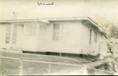
Photographs- Original S.E.C.V. home designs in Mt Beauty – Set of 6 black and white photographs
The townships of Mount Beauty and Bogong Village were constructed by the Victorian State Electricity Utility Commission (SEC) from the 1930’s to the 1950’s to house workers on the Kiewa Hydro Electric Scheme. At its peak the Kiewa Scheme employed around 4000 people. Although the towns were built as temporary accommodation for the workers and their families, many stayed and even retired there after the scheme had finished. The Bright Council, now the Alpine Shire took over the control of the township in 1960 and today Mount Beauty is one of the most complete company towns in Victoria.The SECV provided several standard designs for the housing of workers and management in Mt Beauty. At the completion of the scheme the housing was retained and Mount Beauty now exists as one of the best examples of a company town in Victoria.There are many examples of the original houses remaining around the town. This is significant as the houses were only built as temporary accommodation and still remain functional after over 60 or more years of use.Set of 6 black and white photographs of original SECV temporary house designs in Mt Beauty.Written in blue ink on front of photos 1. Winwood 2. Winwood 3. K Type 4. K Type 5. English Precut 6. Cube mt beauty houses, secv housing -
 Bacchus Marsh & District Historical Society
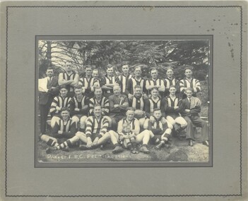
Photograph, Darley Football Club Premiers 1938-1939
Darley football club was formed in 1919. Darley lies on the northern side of the township of Bacchus Marsh. It is part of the overall township of Bacchus Marsh but forms a distinct community within Bacchus Marsh especially in the early period of its history. The area is known as a football breeding ground and has produced many champion players at VFL and AFL level and the club has had sustained success over many decades in various competitions. For many years it played in the Bacchus Marsh District Football Association. From the mid 1990s it has competed in the Ballarat Football League.A black and white photograph print mounted on mounting board, showing a group of 19 players, 3 non playing officials and one child acting as the mascot arranged in three rows. A player in the centre holds a football with D.F.C. Premiers 1939 written upon it. Nineteen men are in football Guernseys, 3 are in civilian clothes. Two of these have towels over their shoulders and are probably trainers. In the centre is the third non-player who is presumably the coach. The photo is taken in an outdoor setting. The child is a young boy dressed in the clubs uniform and sits in the front row between the legs of another player. At the foot of the photo is, "Darley F. B. C. Premiers 1938-39". On the reverse are written some of the players names. Back row: 1. C. Lillburn, 2. ? Cook. 3 Skinner. 4 -----------. 5 Jimmy Younger. 6. Barry. 7. Albie Jones: Middle Row: 1. ----------. 2. McMahon. 3. Ray Closter. 4. Pop Closter. 5 ----------. 6. Mickey Dix. 7 ---------. 8. Densley. Front Row: 1. -----------. 2. Hartley Younger. 3. Whelan. Darley Football Club 1938-39. At to of reverse: 'Donated by the Wittick Family 12 - 1 - 2004. Marie Wittick'.darley football club, australian rules football -
 Bendigo Military Museum
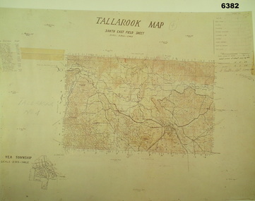
Map - Australian Topographical Survey TALLAROOK SE Sheet, 1 inch:1 Mile, NW portion Plane Table Field sheet 1923, Australian Survey Corps, 1923
This is a coloured reproduction print of an original Plane Table compilation map sheet of Tallarook area 1inch to 1 Mile scale compiled by Sgt Jack Cullen Australian Survey Corps 12 November 1923 and signed by Capt J Lynch. Capt Lynch and Sgt Cullen were both foundation members of the Australian Survey Corps. Of particular interest is the fact that this is a heighted compilation with contouring (required for Military use) as many early maps were purely planimetric. The reverse side of this print is a copy of the Nagambie plane table South West field sheet.Reprinted coloured Image of Australian Topographical Survey TALLAROOK SE field Sheet,1 inch:1 Mile, hand drawn contoured Plane Table Field sheet. Signed by Sgt J Cullen Australian Survey Corps November1923. An enlargement of YEA Township 2 Inches to 1 Mile Scale.royal australian survey corps, rasvy, fortuna, army survey regiment, army svy regt, asr -
Bendigo Historical Society Inc.
Map - ELLESMERE, COUNTY BENDIGO, 17-3-16
Map, Ellesmere, County Bendigo, Goornong, Bagshot, Muskerry, Wellsford, Axedale, Township of Fosterville.Campaspe River, Bendigo Creek, Railway Line.Photographed at the Dept. of Lands and Survey, Melbourne by W.J.Butson 17-3-16.Price 1/-. By authority Albert J.Mullett, Government Printer, Melbourne. ( number 38 in Map Cupboard 1)Albert J.Mullett, Govt. Printer, Melbourne.map, bendigo, ellesmere