Showing 1372 items matching "east side"
-
 Kew Historical Society Inc
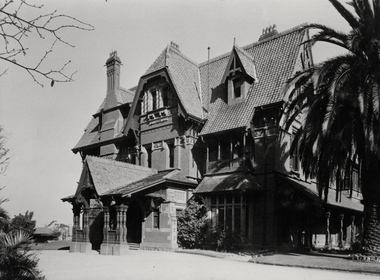
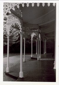
Photograph - Porte-cochere, 'Tara Hall', Studley Park Road, Marc Strizic (attrib), c.1960
'Lost Glories: a memorial to forgotten Australian buildings' was published by David Latta in 1986. It tells the story of a number of significant Australian buildings that had previously been demolished. A chapter in the book was devoted to Goathland, later known as Tara Hall. To supplement the text, he sourced photographs from a range of suppliers, chiefly the Royal Women's Hospital which had once owned Tara Hall, but had sold it in 1960. This is one of the photographs donated to KHS by the author. Porte-cochere, Tara Hall, circa 1957. The main entrance to Tara Hall (previously named Byram, Goathland and Lowan). The entrance, through a porte-cochère, was located on the side of the house facing east. During construction, commentators described the house as being in the ‘Elizabethan style’. The architectural style of the exterior, with its innovatory use of red brick and Italian tiles was more influenced by American models. Edward George Kilburn, of Ellerker & Kilburn, designed Byram for the industrialist George Ramsden in 1888. Typed inscription on reverse: "Goathland, also known as Tara Hall (Royal Women's Hospital, Melbourne)."goathland -- kew (vic), byram -- kew (vic), tara hall - kew (vic), studley park road -
 Kew Historical Society Inc
Photograph, Stuart Tompkins Studio, Electricity Supply Poles, North Road, Ormond, 1965
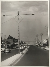
Research provided by Stuart Tompkins Studio, Box Hill, into alternatives for median strip street lighting to be used in Burke Road, Kew. The photographers identified variants in different suburbs appropriate to Kew's needs.The series from which the photograph is drawn provides a snapshot by a commercial photographic studio of each named vicinity in 1965 as well as providing examples of public works infrastructure being commissioned by local government in the 1960s. The photos originally formed part of the Engineering Department's files in the City of Kew before being donated to the kew Historical Society.Electricity Supply Poles, North Road, Ormond, 1965. Electricity supply poles photographed for the Kew City Council by Stuart Tompkins Studio. The photograph of North Road, Ormond west of Jasper Road, looking east depicts wooden poles carrying two lamps in a median strip and with two on each side alternately. It was noted that the supply wires were from one side only. The poles were described as 3′ above ground and 11.25″ in diameter. The plan was to use this approach for Burke Road, Kew. [There are three copies of this photograph in the Collection.] Typed inscription on reverse: "Electricity Supply Poles. Photographed for Kew City Council 8/2/65. No.1 North Road - Ormond, west of Jasper Road, looking east. Wooden poles carrying two lamps in median strip and two on each side alternately just as is proposed for Burke Road, Kew. Supply wires from one side only. Poles 3' above ground 11 1/4" dia." Studio stamp: "Stuart Tompkins Studio. 547 Station Street, Box Hill. WX1439."stuart tompkins studio, street lighting, south road (moorabin) 1965, public infrastructure -- city of kew, city of kew -- engineer's department -
 Kew Historical Society Inc
Photograph, Stuart Tompkins Studio, Electricity Supply Poles, North Road, Ormond, 1965
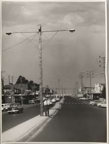
Research provided by Stuart Tompkins Studio, Box Hill, into alternatives for median strip street lighting to be used in Burke Road, Kew. The photographers identified variants in different suburbs appropriate to Kew's needs.The series from which the photograph is drawn provides a snapshot by a commercial photographic studio of each named vicinity in 1965 as well as providing examples of public works infrastructure being commissioned by local government in the 1960s. The photos originally formed part of the Engineering Department's files in the City of Kew before being donated to the kew Historical Society.Electricity Supply Poles, North Road, Ormond, 1965. Electricity supply poles photographed for the Kew City Council by Stuart Tompkins Studio. The photograph of North Road, Ormond west of Jasper Road, looking east depicts wooden poles carrying two lamps in a median strip and with two on each side alternately. It was noted that the supply wires were from one side only. The poles were described as 3′ above ground and 11.25″ in diameter. The plan was to use this approach for Burke Road, Kew. [There are three copies of this photograph in the Collection.] Typed inscription on reverse: "Electricity Supply Poles. Photographed for Kew City Council 8/2/65. No.1 North Road - Ormond, west of Jasper Road, looking east. Wooden poles carrying two lamps in median strip and two on each side alternately just as is proposed for Burke Road, Kew. Supply wires from one side only. Poles 3' above ground 11 1/4" dia." Studio stamp: "Stuart Tompkins Studio. 547 Station Street, Box Hill. WX1439."stuart tompkins studio, street lighting, south road (moorabin) 1965 -
 Kew Historical Society Inc
Photograph, Stuart Tompkins Studio, Electricity Supply Poles, North Road, Ormond, 1965
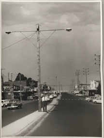
Research provided by Stuart Tompkins Studio, Box Hill, into alternatives for median strip street lighting to be used in Burke Road, Kew. The photographers identified variants in different suburbs appropriate to Kew's needs.The series from which the photograph is drawn provides a snapshot by a commercial photographic studio of each named vicinity in 1965 as well as providing examples of public works infrastructure being commissioned by local government in the 1960s. The photos originally formed part of the Engineering Department's files in the City of Kew before being donated to the kew Historical Society.Electricity Supply Poles, North Road, Ormond, 1965. Electricity supply poles photographed for the Kew City Council by Stuart Tompkins Studio. The photograph of North Road, Ormond west of Jasper Road, looking east depicts wooden poles carrying two lamps in a median strip and with two on each side alternately. It was noted that the supply wires were from one side only. The poles were described as 3′ above ground and 11.25″ in diameter. The plan was to use this approach for Burke Road, Kew. [There are three copies of this photograph in the Collection.] Typed inscription on reverse: "Electricity Supply Poles. Photographed for Kew City Council 8/2/65. No.1 North Road - Ormond, west of Jasper Road, looking east. Wooden poles carrying two lamps in median strip and two on each side alternately just as is proposed for Burke Road, Kew. Supply wires from one side only. Poles 3' above ground 11 1/4" dia." Studio stamp: "Stuart Tompkins Studio. 547 Station Street, Box Hill. WX1439."stuart tompkins studio, street lighting, south road (moorabin) 1965 -
 Freemasons Victoria - Gordon Lodge, 99
Original Gordon Lodge lodge-room 1886
A picture of the original Gordon Lodge lodge-room of 1886 - room currently in use by the Lodge's artist-in-residence. Below is a newspaper article from the North Melbourne Advertiser (Vic: 1873 - 1894) for Friday 22 April 1887 that describes the architecture of the building at the time of its completion. From some of the details included in the article it is obvious that the journalist who wrote the article was a Freemason. THE MASONIC HALL ASCOT VALE North Melbourne Advertiser (Vic. : 1873 - 1894) Friday 22 April 1887 THE MASONIC HALL ASCOT VALE The now Masonic Hall, Ascot Vale, the foundation stone of which was laid by the Worshipful Master of the Gordon Lodge (Bro, W. F. Lamonby) in October last has just been completed, and will be formally opened: with grand Masonic ball on the 13th prox. The hall stands on a fine block of land having a frontage of 50ft to the Maribyrnong road by a depth of 130 ft., and is built of brick and cement on a most substantial foundation of bluestone. The Tuscan style of architecture has been adopted with the most successful result, and the front design which is especially handsome, includes four massive pilasters with frieze architrave and enriched cornice, forming the entablature of the order,- and giving a most imposing appearance. The front door, over which are the masonic emblems, is seven feet wide, and two escape doors made to open outwards in compliance with the Central Board of Health regulations are also provided, in case of emergency. In the vestibule is a very fine elliptic arch with keystone enriched with fruit, and the whole floor, 9ft. 6in. wide, is laid with Cawkwell's encaustic tyles. On the right, of tile vestibule is a commodious committee room 22ft. by 12ft 6in with side entrance for members, so that in case the main hall is engaged no inconvenience need be caused. On the left is the Secretary's room, and off this again is a staircase cellar. The vestibule is well lighted with two exceedingly pretty chandeliers, which have a very pleasing effect and give it a nice bright appearance ascending a handsome staircase leading from the vestibule the upper storey is reached, and here everything is splendidly arranged, especially 'the Lodge Room, which is a model of neatness and of comfort. The dimensions are 28ft. x 22ft 6in. with an elevation of 17ft. 6in. to the beautiful cove ceiling, which is quite a work of art. At the east end of the room on a raised dais is the master's chair with the masonic emblems, and neat forms of polished kauri are placed at the sides for members, about 150 of whom can be accommodated. The lighting and ventilation have both been well attended to and all is very complete. The main hall is 75ft. by 35 ft. with a stage 15ft. deep, leaving the auditorium 60ft. x 35ft. with a seating capacity about 600. Round the walls up to 6ft 6in. is a handsome dado in Portland cement and above it are panelled Tuscan pilasters to the entablature, architrave enriched frieze and medallion cornice forming the main cornice to the hall. Immediately inside the cornice is a sunken panel all-round the ceiling relieved with ornamental outlet ventilators. There are twelve large windows, six on each aide, and the sashes, skirting boards, and doors throughout the building are beautifully painted in imitation of grained cedar. Two enormous gas reflectors, each for 50 lights are suspended from the ceiling and besides these, four elegant hanging chandeliers for lighting up the proscenium, and back of the stage, under which is a storeroom for seats, &c, when the hall is required for a ball. The floor is made of kauri, secretly nailed, and is beautifully finished off. At the back of the stage are two lavatories and ladies and gentlemen's dressing rooms, between which are a connecting passage for a call boy. Outside is a capital asphalted yard, and the other usual conveniences on an improved plan. There is a right-of-way asphalted on each side of the building, and a large lamp is to be placed opposite the main entrance to light up the front. Everything that forethought and ability could suggest to make the hall comfortable and popular has been done, and it now only remains for the public to avail themselves of the advantages offered them by the enterprising Company. The cost of the building and furniture, including a magnificent piano, was £2,500, and the land £300. Mr J. C. M. Cowan, of Ascot Vale, is the architect, and Messrs Parker and Pater, of South Melbourne, the contractors. The plastering was done by Mr I Nicholas, of Murray Street, Moonee Ponds, who is also entitled to great praise for his splendid workmanship. Mr Cowan has been most assiduous and particular in seeing that his instructions were carried out to his satisfaction, and the result must be exceedingly gratifying to him and to the directors. The Masonic hall is only one of the many buildings erected by Mr Cowan in this district, among the others being the well known residences of Meessrs. J. Levy, Mooneo Street; W. Murphy, Eglington street; G. Groube, Maribyrnong street; C. A. Arvier, Moonee Ponds ; and F. Paul, Mount Alexander road. It may also be mentioned that Mr Cowan generously presented the plans for the now local fire brigade tower which is acknowledged to be one of the strongest and most graceful around Melbourne, The new Masonic Hall does infinite credit to the borough, and in accommodation, design, and comfort it is not surpassed by any similar building of the kind outside the city. -
 Kew Historical Society Inc
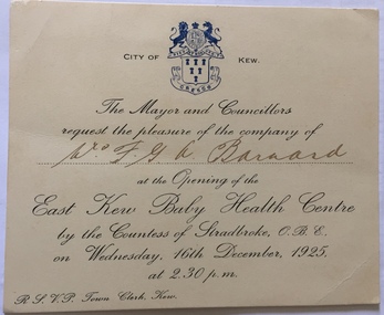
Document (item) - Invitation, City of Kew, Opening of the East Kew Baby Health Centre, 1925
The Municipality of Kew (1860-1863), the Borough of Kew (1863-1910), the Town of Kew (1910-1921) and the City of Kew (1921-1994) were local government instrumentalities in the State of Victoria. In 1994, the City of Kew was amalgamated, together with the former Cities of Camberwell and Hawthorn, into the new City of Boroondara (1994- ). Like other local government entities of the period, Kew was administered by town clerks. The two notable town clerks in Kew's history were H. H. (Henry Hirst) Harrison (1868-1955) and W. D. (William Dickie) Birrell (1899-1974). Harrison was appointed to the position in 1901 and retired in 1938 after 37 years. Birrell, appointed Acting Town Clerk in 1921, became Town Clerk in 1938, following Harrison's retirement. He continued in this role until his retirement in 1966.This card is part of an historically significant civic collection, containing hundreds of separate invitations, documents, greeting cards, programmes and tickets issued and/or collected by successive town clerks. Items in the collection illuminate the political, social and cultural history of the district. As a continuous record, ranging across most decades of the Twentieth Century, they reveal changing tastes in design, values and relationships in the history of local government in Victoria.CITY OF KEW / THE MAYOR AND COUNCILLORS / REQUEST THE PLEASURE OF THE COMPANY OF / Mrs FGA Barnard / AT TH EOPENING OF THE / EASK KEW BABY HEALTH CENTRE / civic invitations -- kew (vic), mrs fga barnard, east kew baby health centre, countess of stradbroke, social services -- kew (vic.) -
 Kew Historical Society Inc
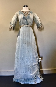
Clothing - Pale Blue Muslin, Silk, & Lace Dress, 1910-14
The dress was in the cupboard of Muriel Kerr, the donor's recently deceased mother. The donor remembers being shown it and trying it on in the late '70s or early '80s and being told that it belonged to her great-grandmother, Lilian Armstrong Ballantine (nee Power) [1887-1967]. Lilian Ballantine lived at 31 Harp Road (now the site of the Leo Baeck Centre) from the early 1920s to 1967. Lilian's married Archibald Dill Ballantine [1883-1947], in 1910. He was a member of the Monumental firm of A&G Ballantine, responsible for the Kew War Memorial (and possibly the Springthorpe Memorial). Lilian was highly involved with the Finlay McQueen Memorial Church [ie the East Kew Presbyterian Church]. Lilian's daughter, Mary (the donor's grandmother) married Alan McQueen, the son of Finlay McQueen, the first Minister of the East Kew Church. Mary Macqueen lived at 1 Oswin Street; she was a well-known artist. The dress is significant due to its associations with a family with strong connections, through a number of generations, to Kew East and its spiritual institutions. The garment's integrity and design also contribute to its aesthetic significance as a representative item of women's outerwear during the first decades of the twentieth century.Pale blue striped muslin single-piece dress with lace, tulle and embroidery at the neck and on the cuffs. The lace at the neck and cuffs is embroidered with coloured flowers, and edged with tulle. Bordering the v-neckline is a deeper blue guipure lace (possibly added later). There is a satin flower on the right side of the skirt which gathers the hem, exposing the deeper blue cotton underskirt. The dress has a narrow band of blue satin at the high waist. The cotton underskirt is attached by thread in places to the outer layer. Both the outer and under layers are attached with metal hooks and eyes. Edging the cuffs and hem of the dress is blue commercial fringing. The exterior of the dress has a slight brown tinge which is not apparent on the inside hem, suggesting that it has been discoloured through exposure. There are minor stains.women's clothing, edwardian dresses, lilian ballantine, australian fashion - 1910s, mary macqueen, finlay mcqueen memorial church, east kew presbyterian church, alan mcqueen, kew war memorial, archibald dill ballantine, leo baeck centre, 31 harp road -- kew (vic.), a&g ballantine, women's clothing -- 1900s, fashion - 1900s, fashion design -
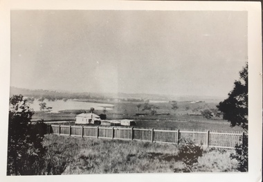
 Kew Historical Society Inc
Photograph - Yarra in Flood - Belford & Kilby Farms, 1903
In 1980, Mr Laurie Bennett presented the Kew Historical Society with a number of photographs and postcards from the estate of his mother Eileen Mary Bennett (nee Clark). His mother was the daughter of Lawrence FH Clark(?-1946) and Mary Clark (?-1925) of 22 Harp Road, East Kew, in whose yard the photograph was taken. A year before the donation occurred a notice appeared in the Canberra Times stating that: "BENNETT, Eileen Mary. — May 8th at Tuross Heads, N.S.W. Late of 22 Harp Rd, East Kew, (Vic). Dearly loved wife of the late Harold Bennett, loved mother and mother in law of Laurie and Shirley (Melbourne), Kevin and Doreen (Canberra), grandmother of Linda, Stephen, Paul, Gabrielle, Peter, Mark and Jon."Part of a large collection of photographs and postcards in the collectionPanoramic photographic positive of North Kew where the Belford and Kilby Farms were located on the south side of the Yarra River. This photo, donated in 1980 by Laurie Bennett is the original of the two identical photos in the collection.laurie bennett, eileen mary bennett, eileen mary clark, floods -- yarra -- 1903 -
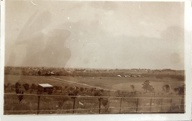
 Kew Historical Society Inc
Photograph - Yarra in Flood - Belford & Kilby Farms, 1903
The Yarra Valley in what was previously called North Kew, but is now East Kew, was frequently subjected to flooding. Apart from some development on higher ground, the City of Kew regularly introduced restrictions on development and the building of housing in the area because of flood levels. Panoramic photographic positive of North Kew where the Belford and Kilby Farms were located on the south side of the Yarra River. This photo is a copy of the original photo in the collection.floods -- yarra -- 1903, kew golf course, greenacres golf course -
 Kew Historical Society Inc
Photograph - High Street, Kew, 1960-65
The borders of the main components of Kew and Kew East have not always conformed to current boundaries. In the past this photograph has been labelled as East Kew, whereas for most of the twentieth century the site has been within Kew's borders. The purpose of the photograph is unrecorded yet it has value in that it shows those businesses who occupied this site in Kew during the early 1960s.This small photograph is significant as it shows the location of and building used by WD Vaughan, former Mayor of Kew who was a successful newspaper proprietor in Melbourne.Small polaroid colour positive of High Street in Kew, probably in the 1960s. From left we can see the brick viaduct covering the tracks of what was once the Outer Circle Railway. Behind this brick wall, Dunnings Timber Yard was situated. At the end of the walls of the viaduct there is an entrance to a walkway [now the Anniversary Trail], which once provided access to Windsor Avenue, and also to the East Kew Station (now demolished and part of the Outer Circle Railway Reserve). On the other side of this walkway is a cream brick building (demolished) occupied at this time by WD Vaughan Pty Ltd, printer and publisher of the Kew Advertiser (newspaper). Stretching behind the brick facade is an extensive building that must have housed the printing works. Beside Vaughan's, there is a large building (demolished) housing at that time an estate agent named AJ Kennedy. This area is now separated by kerbing.High St East Kew / Corner of Harp Rd. / Looking South -
 Kew Historical Society Inc
Photograph - Yarra Valley Floods: Kew East, 1916
Flooding of the Yarra Valley, including that section of the Yarra bordering Kew and Kew East in the north and west of the municipality, was a regular occurrence. Extreme flood events of the Yarra River are recorded to have occurred in 1891, 1901, 1916, 1923 and 1934. The Municipality of Kew's response to these floods was to enact planning decisions restricting residential development in flood prone areas following the floods of 1916, 1921 and 1934. While floods continued after the development of the Upper Yarra Reservoir (construction 1948-57), the regularity and extent of these inundations diminished. During the nineteenth century, the land abutting the south side of the Yarra in Kew was devoted to dairy farming. In the twentieth century, before and after the construction of the Eastern Freeway, much of this low-lying area was used as golf courses and public parks.One of a collection of photographs of flooding in the Kew section of the Yarra Valley which are in important research resource for the location and extent of flooding in the first half of the twentieth century. Flooding of the Yarra Valley at East Kew in 1916. The view is taken from the intersection of Kilby Road with what is believed to be Birdwood Street, looking across the flood waters to Ivanhoe. The extensive flooded area shown in the photograph would have included the Kew Golf Club. Verso: "Floods along Kilby Road / near Birdwood St? & Kilby Road / 1917? / 87yarra river, yarra valley, floods -- kew, kilby road -- kew (vic.), kew golf club -
 Kew Historical Society Inc
Photograph - Yarra Valley at Kew, 1918
During the nineteenth century, the land abutting the south side of the Yarra in Kew was devoted to dairy farming. In the twentieth century, before and after the construction of the Eastern Freeway, much of this low-lying area was used as golf courses and public parks.View of the farmland in the Yarra Valley at what is believed to be East Kew in 1918. Verso: "Willsmere / East Kew? / 1918"yarra river, yarra valley -
 Kew Historical Society Inc
Photograph - Yarra Valley Floods: Kew East, 1916
Flooding of the Yarra Valley, including that section of the Yarra bordering Kew and Kew East in the north and west of the municipality, was a regular occurrence. Extreme flood events of the Yarra River are recorded to have occurred in 1891, 1901, 1916, 1923 and 1934. The Municipality of Kew's response to these floods was to enact planning decisions restricting residential development in flood prone areas following the floods of 1916, 1921 and 1934. While floods continued after the development of the Upper Yarra Reservoir (construction 1948-57), the regularity and extent of these inundations diminished. During the nineteenth century, the land abutting the south side of the Yarra in Kew was devoted to dairy farming. In the twentieth century, before and after the construction of the Eastern Freeway, much of this low-lying area was used as golf courses and public parks.One of a collection of photographs of flooding in the Kew section of the Yarra Valley which are in important research resource for the location and extent of flooding in the first half of the twentieth century. Flooding of the Yarra Valley at East Kew in 1916. The view is taken from a street (maybe Birdwood Avenue) intersecting with Kilby Road looking northeast across the flood waters to Ivanhoe and Heidelberg. The extensive flooded area shown in the photograph would have included remnant dairy farms and the Kew Golf Club. Verso: "Floods / Yarra River / East Kew / Kilby Road / 1917? / 87"yarra river, yarra valley, floods -- kew, kilby road -- kew (vic.), kew golf club -
 Kew Historical Society Inc
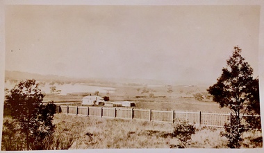
Photograph - Yarra Valley at Kew, 1912
During the nineteenth century, the land abutting the south side of the Yarra in Kew was devoted to dairy farming. In the twentieth century, before and after the construction of the Eastern Freeway, much of this low-lying area was used as golf courses and public parks.Real-photo postcard of the farmland in the Yarra Valley in what is believed to be North Kew in 1912. Verso: "Willsmere / East Kew / 1912"yarra river, yarra valley, farming -- kew (vic.) -
 Kew Historical Society Inc
Photograph - Civic event in Stradbroke Park, 1976
Stradbroke Park. Extent: Kilby Road to Harp Road at Burke Road. Historical Documentation: 1851 - Portion 91 purchased by Edward Glynn; 1888 - The Harp of Erin Estate (which included Section 91) offered for sale; 1896 - The area now known as Stradbroke Park was bisected by a creek that flowed from the Yarra via Hay's Paddock (q.v.) and extended through to Burke Road; 1943 - W.D. Birrell, Town Clerk of Kew, proposed that the creek be filled and a reserve created; 1954 - Entire area designated as 'open space' and named 'Stradbroke Park'. The line of the creek that ran through the Park created a further reserve on the north side of High Street, now known as 'Harrison Reserve'. Existing Condition: The park is largely of mown grass that has mature trees set into it It is possible that a number of these are remnant of the original vegetation, while there are also a number of exotic trees introduced, particularly at the northern end of the park. The southern end is dominated by playing fields. (Source: Sanderson, P 1988. Kew Conservation Study)Colour photographic positive (with colour degradation) of sporting teams at a civic event in Stradbroke Park in Kew East in May 1976. The event was officiated by the Mayor of Kew, Cr Alan Hutchinson. Sporting teams in uniform included: footballers, athletes, cricketers, hockey players. Stradbroke Park is situated on the western boundary of Kew at Burke and Harp Roads.stradbroke park, cr alan hutchinson, team sports -- kew (vic.) -
 Kew Historical Society Inc
Photograph - Civic event in Stradbroke Park, 1976
Stradbroke Park. Extent: Kilby Road to Harp Road at Burke Road. Historical Documentation: 1851 - Portion 91 purchased by Edward Glynn; 1888 - The Harp of Erin Estate (which included Section 91) offered for sale; 1896 - The area now known as Stradbroke Park was bisected by a creek that flowed from the Yarra via Hay's Paddock (q.v.) and extended through to Burke Road; 1943 - W.D. Birrell, Town Clerk of Kew, proposed that the creek be filled and a reserve created; 1954 - Entire area designated as 'open space' and named 'Stradbroke Park'. The line of the creek that ran through the Park created a further reserve on the north side of High Street, now known as 'Harrison Reserve'. Existing Condition: The park is largely of mown grass that has mature trees set into it It is possible that a number of these are remnant of the original vegetation, while there are also a number of exotic trees introduced, particularly at the northern end of the park. The southern end is dominated by playing fields. (Source: Sanderson, P 1988. Kew Conservation Study)Colour photographic positive (with colour degradation) of sporting teams at a civic event in Stradbroke Park in Kew East in May 1976. The event was officiated by the Mayor of Kew, Cr Alan Hutchinson. Stradbroke Park is situated on the western boundary of Kew and bordered by Burke and Harp Roads.stradbroke park, cr alan hutchinson, team sports -- kew (vic.) -
 Kew Historical Society Inc
Photograph - Studley Park, 1937
Those sections of Studley Park closest to the River Yarra were set aside as parkland in the 1850s. After initial discussions about whether it was a suitable site for a Government House, much of the land was instead gazetted in the 1860s as the location for a new lunatic asylum, to expand overcrowded mental health facilities at the Yarra Bend Asylum on the other side of the river at Fairfield. Those sections of Studley Park bounded by the Yarra River, Studley Park Road, Princess Street and Fellows Street were subdivided and sold at the Crown Land Sales in 1851. Much of this urban area remained open farmland until the twentieth century, apart from mansions, largely located along the main roads.Original, black and white positive print of what is said to represent Studley Park in 1937. If the attribution and date is literally to be understood, then it would appear that the photograph may have been taken from the Kew side of the river looking across to open farmland in the Yarra Bend Park. If the designation of Studley Park is to be understood more loosely, then it might be a view of what is now East Kew, taken from a section of Kilby Road. Inscribed verso: "Studley Park 1937" studley park -- kew (vic.) -
 Kew Historical Society Inc
Photograph - Verandah of 'Wimba', 235 Cotham Road, John T Collins, 1979
Although probably built some time earlier, the first mention in the Rate Books of the property later known as 'Wimba Lodge' appears in the entry for 1870 when the property, owned by John Sharpe Denbigh, a civil servant, was given an N.A.V. of £72. Denbigh did however occupy a house in Cotham Road in 1863, and it is possible that was the same premises'. The house was occupied by Sharp until at least May 1876 when the 'family residence ... was auctioned' to Carlington George Edmund Marston, a chemist of Smith Street, Collingwood. At the time of the auction the house was described thus: The residence and grounds of the late J.S. Dendigh, situate in the most elevated part of Cotham Road Kew. The grounds comprise an area of 4a Or 29p or thereabouts, and have a frontage to Cotham-road of 4 chains. The house has two large rooms in front, with 6ft hall built of brick, bay and side windows (plate glass), four rooms of wood behind with slate roofs, bathroom and closets, detached kitchen and servant's room, large shed with washing boiler, pantry and cellar under, brick and cement tank, and the Yan Yean laid onto house and grounds, cowshed, pigstye, &c, the whole securely fenced. First class orchard and flower garden. The paddocks laid with English grasses and drained... .' (Sanderson P. Kew Conservation Study Vol 2)'Wimba' is a single storeyed rendered house. The front entrance is flanked by two polygonal bay windows, and a verandah with a concave corrugated iron roof returns around three facades, and accentuates the projections of the windows. The solid render parapet is very ornate and tall for the date of construction. It has panels of decoration along it and is surmounted by a number of render urns. (Sanderson P. Kew Conservation Study Vol 2)Reverse: "JOHN COLLINS / 11 Anderson Road / Hawthorn East, 3123 / Film 395 Exposure 15A / Kew / Wimba / Front verandah from east / 7-4-79wimba lodge, 235 cotham road -- kew (vic.), john s denbigh, carlington george edmund marston -
 Kew Historical Society Inc
Photograph - Flooding of the Yarra Valley at Kew East, 1974
Flooding of the Yarra Valley, including that section of the Yarra bordering Kew and Kew East in the north and west of the municipality, was a regular occurrence. Extreme flood events of the Yarra River are recorded to have occurred in 1891, 1901, 1916, 1923 and 1934. The Municipality of Kew's response to these floods was to enact planning decisions restricting residential development in flood prone areas following the floods of 1916, 1921 and 1934. While floods continued after the development of the Upper Yarra Reservoir (construction 1948-57), the regularity and extent of these inundations diminished. During the nineteenth century, the land abutting the south side of the Yarra in Kew was devoted to dairy farming. In the twentieth century, before and after the construction of the Eastern Freeway, much of this low-lying area was used as golf courses and public parks.Late example of the capacity of the Yarra Valley at Kew to flood, even though drainage works and the Upper Yarra Reservoir had reduced their regularity.Original black and white print photograph of the low-lying land at East Kew under floodwater on 16 May 1974. The vantage point of the photographer is Lister Street. In the photo, the fences of the Kilby Farm can be seen. Flooding was caused by overflowing water in Glass' Creek and the River Yarra. Annotation verso: "Hay's Paddock op No.30 Lister Street / 16 May 1974 11.50am / R.L. 46.04"hays paddock, floods, yarra river, glass' creek, lister street -
 Kew Historical Society Inc
Photograph - Flooding of the Yarra Valley at Kew East, 1974
Flooding of the Yarra Valley, including that section of the Yarra bordering Kew and Kew East in the north and west of the municipality, was a regular occurrence. Extreme flood events of the Yarra River are recorded to have occurred in 1891, 1901, 1916, 1923 and 1934. The Municipality of Kew's response to these floods was to enact planning decisions restricting residential development in flood prone areas following the floods of 1916, 1921 and 1934. While floods continued after the development of the Upper Yarra Reservoir (construction 1948-57), the regularity and extent of these inundations diminished. During the nineteenth century, the land abutting the south side of the Yarra in Kew was devoted to dairy farming. In the twentieth century, before and after the construction of the Eastern Freeway, much of this low-lying area was used as golf courses and public parks.Late example of the capacity of the Yarra Valley at Kew to flood, even though drainage works and the Upper Yarra Reservoir had reduced their regularity.Original black and white print photograph of the low-lying land at East Kew under floodwater on 16 May 1974. The vantage point of the photographer is Lister Street. Flooding was caused by overflowing water in Glass' Creek and the River Yarra. Annotation verso: "Lister Street looking north / Flood level / 16 May 1974 11.30am / R.L. 46.04"hays paddock, floods, yarra river, glass' creek, lister street -
 Kew Historical Society Inc
Photograph - Flooding of the Yarra Valley at Kew East, 1974
Flooding of the Yarra Valley, including that section of the Yarra bordering Kew and Kew East in the north and west of the municipality, was a regular occurrence. Extreme flood events of the Yarra River are recorded to have occurred in 1891, 1901, 1916, 1923 and 1934. The Municipality of Kew's response to these floods was to enact planning decisions restricting residential development in flood prone areas following the floods of 1916, 1921 and 1934. While floods continued after the development of the Upper Yarra Reservoir (construction 1948-57), the regularity and extent of these inundations diminished. During the nineteenth century, the land abutting the south side of the Yarra in Kew was devoted to dairy farming. In the twentieth century, before and after the construction of the Eastern Freeway, much of this low-lying area was used as golf courses and public parks.Late example of the capacity of the Yarra Valley at Kew to flood, even though drainage works and the Upper Yarra Reservoir had reduced their regularity.Original black and white print photograph of Hay's Paddock under floodwater on 16 May 1974. The vantage point of the photographer is Keystone Crescent looking east. Flooding was caused by overflowing water in Glass' Creek and the River Yarra. Annotation verso: "Keystone Cr looking east / 16 May 1974 11.50am"hays paddock, floods, yarra river, glass' creek -
 Kew Historical Society Inc
Photograph - Flooding of the Yarra Valley at Kew East, 1974
Flooding of the Yarra Valley, including that section of the Yarra bordering Kew and Kew East in the north and west of the municipality, was a regular occurrence. Extreme flood events of the Yarra River are recorded to have occurred in 1891, 1901, 1916, 1923 and 1934. The Municipality of Kew's response to these floods was to enact planning decisions restricting residential development in flood prone areas following the floods of 1916, 1921 and 1934. While floods continued after the development of the Upper Yarra Reservoir (construction 1948-57), the regularity and extent of these inundations diminished. During the nineteenth century, the land abutting the south side of the Yarra in Kew was devoted to dairy farming. In the twentieth century, before and after the construction of the Eastern Freeway, much of this low-lying area was used as golf courses and public parks.Late example of the capacity of the Yarra Valley at Kew to flood, even though drainage works and the Upper Yarra Reservoir had reduced their regularity.Original black and white print photograph of the low-lying land at East Kew under floodwater on 16 May 1974. The vantage point of the photographer is Lister Street. Flooding was caused by overflowing water in Glass' Creek and the River Yarra. Annotation verso: "Lister St looking same as No.3 / 16 May 1974 11.30"floods, yarra river, glass' creek, lister street -
 Kew Historical Society Inc
Photograph - Flooding of the Yarra Valley at Kew East, 1974
Flooding of the Yarra Valley, including that section of the Yarra bordering Kew and Kew East in the north and west of the municipality, was a regular occurrence. Extreme flood events of the Yarra River are recorded to have occurred in 1891, 1901, 1916, 1923 and 1934. The Municipality of Kew's response to these floods was to enact planning decisions restricting residential development in flood prone areas following the floods of 1916, 1921 and 1934. While floods continued after the development of the Upper Yarra Reservoir (construction 1948-57), the regularity and extent of these inundations diminished. During the nineteenth century, the land abutting the south side of the Yarra in Kew was devoted to dairy farming. In the twentieth century, before and after the construction of the Eastern Freeway, much of this low-lying area was used as golf courses and public parks.Late example of the capacity of the Yarra Valley at Kew to flood, even though drainage works and the Upper Yarra Reservoir had reduced their regularity.Original black and white print photograph of the low-lying land at East Kew under floodwater on 16 May 1974. The vantage point of the photographer is at Willsmere Road. The road itself is underwater.Annotation verso: "Willsmere Rd / Same as No.7 / 16 May 1974 11.15am"floods, yarra river, willsmere road -
 Kew Historical Society Inc
Photograph - Flooding of the Yarra Valley at Kew East, 1974
Flooding of the Yarra Valley, including that section of the Yarra bordering Kew and Kew East in the north and west of the municipality, was a regular occurrence. Extreme flood events of the Yarra River are recorded to have occurred in 1891, 1901, 1916, 1923 and 1934. The Municipality of Kew's response to these floods was to enact planning decisions restricting residential development in flood prone areas following the floods of 1916, 1921 and 1934. While floods continued after the development of the Upper Yarra Reservoir (construction 1948-57), the regularity and extent of these inundations diminished. During the nineteenth century, the land abutting the south side of the Yarra in Kew was devoted to dairy farming. In the twentieth century, before and after the construction of the Eastern Freeway, much of this low-lying area was used as golf courses and public parks.Late example of the capacity of the Yarra Valley at Kew to flood, even though drainage works and the Upper Yarra Reservoir had reduced their regularity.Original black and white print photograph of the low-lying land at East Kew under floodwater on 16 May 1974. The photograph is of Hyde Park looking north-east.Annotation verso: "Hyde Park looking nth-east / Flood Level / 16 May 1974 11.15am / R.L. 46.61"floods, yarra river, hyde park -
 Kew Historical Society Inc
Photograph - Flooding of the Yarra Valley at Kew, 1974
Flooding of the Yarra Valley, including that section of the Yarra bordering Kew and Kew East in the north and west of the municipality, was a regular occurrence. Extreme flood events of the Yarra River are recorded to have occurred in 1891, 1901, 1916, 1923 and 1934. The Municipality of Kew's response to these floods was to enact planning decisions restricting residential development in flood prone areas following the floods of 1916, 1921 and 1934. While floods continued after the development of the Upper Yarra Reservoir (construction 1948-57), the regularity and extent of these inundations diminished. During the nineteenth century, the land abutting the south side of the Yarra in Kew was devoted to dairy farming. In the twentieth century, before and after the construction of the Eastern Freeway, much of this low-lying area was used as golf courses and public parks.Late example of the capacity of the Yarra Valley at Kew to flood, even though drainage works and the Upper Yarra Reservoir had reduced their regularity.Original black and white print photograph of the low-lying land at East Kew under floodwater on 16 May 1974. The photograph is taken from 43 Kellett Grove.Annotation verso: "Kellett Gve No.43 / Flood Level / 16 May 1974 11.40am"floods, yarra river, kellett grove -
 Kew Historical Society Inc
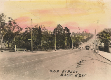
Postcard - High Street, East Kew, c.1927
High Street, Kew is the main Road in Kew. It was once also known as Bulleen Road, or Main Street. This section of the road is in Kew, although the narrow section on the right hand side of the photo is now Kew East. High Street progresses through a number of significant road junctions: beginning at Barkers Road; progressing through the intersection of Studley Park Road, Denmark Street and Princess Street at Kew Junction; branching left at the junction with Cotham Road; before reaching the junction with Valerie Street and Harp Road. It reaches its end at the junction of Burke Road, Kilby Road, Bulleen Road and High Street itself. An early photograph of this iconic Memorial that locates it in its context. Small, colorised real photo postcard of High Street, East Kew. Electric light poles line the road. Victoria Park is on the left and further on the horizon is the Boroondara General Cemetery.high street -- kew (vic.), victoria park, tram lines -- kew (vic.) -
![Photograph - c. 1900s, [Illegible], Rock of Ages in Statuary and Song, c.1900s](/media/collectors/5423a8ba2162f1155cc09d2a/items/542cca6a2162f1124caadfb6/item-media/542cccd72162f1124caaf841/item-fit-380x285.jpg) Expression Australia
Expression AustraliaPhotograph - c. 1900s, [Illegible], Rock of Ages in Statuary and Song, c.1900s
Deaf women dressed in white flowing robes were typically used by the Society at meetings and lectures giving a performance in living statuary. This photograph is a depiction from Rock of Ages in Statuary and Song described in a review by the Spectator - the words of the hymn softly sung by the Cornish Choir to an exquisitely delicate organ accompaniment by Mr E. J. Watkins. The Grouping of Living Statuary with the limelight thrown upon them from either side, motionless as marble figures, but with the life and love and adoration in their eyes and on their faces, formed the most beautiful objects we have ever beheld. The Audience looked and listened in breathless silence and many eyes were glistening with tears.This photo is significant as a studio photograph of Deaf women who performed 'living statuar'y at many of the lectures and meetings held in the early years of the 20th century by the Adult Deaf and Dumb Society of Victoria ; possibly introduced by Ernest Abraham to add drama to the occasion.A5 black and white photograph on a cardboard frame. The photograph features five women in robes surrounding a cross."City Chambers / 114 Elizabeth Street / Melbourne" Signature of photographer or studio name illegible. -
 Expression Australia
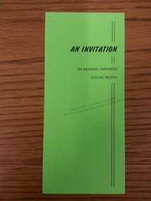
Invitation, An Invitation to Hearing Impaired Young People
An invitation from The Australian Association for Better Hearing and H.E.A.R. Service a program of the Adult Deaf Society of VictoriaGreen colour, 21.5cmHx9.5cmW, 4 sidesaustralian association for better hearing, h.e.a.r. service, adult deaf society of victoria -
 Brimbank City Council Art Collection
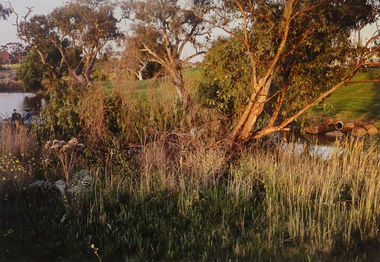
Photograph, Kororoit Creek, Opposite Deer Park Hotel, 1994
... Opposite Deer Park Hotel, West Side Kororoit Creek looking... Landscape photograph landscape Opposite Deer Park Hotel, West Side ...Local LandscapeOpposite Deer Park Hotel, West Side Kororoit Creek looking East AR0108photograph, landscape