Showing 2026 items matching "mt beauty"
-
 Kiewa Valley Historical Society
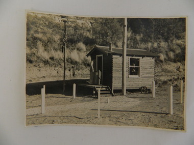
Photo - Air Observers' Hut SECV during WWII, 24 May 1943
... Centre 31 Bogong High Plains Rd Mt Beauty high-country During WW2 ...During WW2 there were volunteers all over Australia observing air activity every night. This photo was taken from the S.E.C.V. hut dedicated to this activity and was manned by men and women throughout the war. The State Electricity Commission of Victoria were based at Bogong when constructing the Kiewa Hydro Electric Scheme. The State Electricity Commission of Victoria dedicated a hut at Bogong township during World War 2 for the purpose of volunteers manning the hut to observe air craft. This was during the construction of the Kiewa Hydro Electric Scheme. See also KVHS 0938 (certificate) and KVHS 1259 (Training Manual)Black and white photo of the State Electricity Commission of Victoria's 'Volunteer Air Observer's Hut' at Bogong during World War 2.- 24th May 1943On back of photo: "EW / K1156 / 24 May 1943 / Volunteer Air Observers Hut / During World War 2 / Bogong"secv, bogong, wwii -
 Kiewa Valley Historical Society
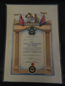
Certificate - Volunteer Air Observers Corps, 20th September1945
... Centre 31 Bogong High Plains Rd Mt Beauty high-country During ...During WWII there were volunteers all over Australia observing air activity every night. This certificate is one that was presented to the volunteers who manned the observation points. This certificate was presented to Mr Gordon White of Mount Beauty who was one such volunteer on the 20th Sept. 1945.The State Electricity Commission of Victoria were constructing the Kiewa Hydro Electric Scheme during World War 2. Workers lived at Bogong where the SECV supplied a hut for volunteers to observe air traffic during World War II. Mr Gordon White was a volunteer at the time. See also KVHS 0937 (photo) and KVHS 1259 (Training Manual)Laminated coloured A3 size Certificate of appreciation RAAF for Volunteer Air Observers Corps.volunteer air observer corps; certificate; state electricity commission of victoria; bogong; gordon white -
 Kiewa Valley Historical Society
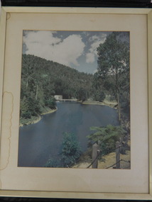
Framed photo - Clover Power Station and Dam
... Centre 31 Bogong High Plains Rd Mt Beauty high-country Clover Dam ...Clover Dam and Power Station were built by the State Electricity Commission of Victoria as part of the Kiewa Hydro Electric Scheme from the late 1930's to the early 1940's.This photo is part of the local history and was owned by Mr ad Mrs Gordon White, SECV employee and long time residents.White wooden frame coloured photo with white cardboard surrounds of Clover Power Station and Dam.clover dam; clover power station; bogong; kiewa hydro electric scheme; -
 Kiewa Valley Historical Society
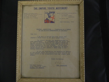
Framed Letter - Bogong State School, 1950
... Centre 31 Bogong High Plains Rd Mt Beauty high-country In 1950 ...In 1950, the "Project Competition - Australia as a Member of the British Commonwealth of Nations" was conducted. Bogong State School was awarded a First Prize in the competition. The prize being 10 pounds to be used to purchase books for the school library on Empire subjects. Bogong is a local town established by the State Electricity Commission of Victoria during the construction of the Kiewa Hydro Electric Scheme. This letter is significant in that it shows that the British Empire was very relevant to the population at the time and being promoted in schools.Cream decorated frame with glass front and paper backing. Two rings are screwed into the top sides of the back of the frame with one plastic cord and one piece of string between them. The framed letter is titled 'The Empire Youth Movement", dated 22nd February, 1950 and addressed to the Head Teacher of the Bogong State School. Blue print with colored square in the middle at the top. bogong state school; empire youth movement; certificate -
 Kiewa Valley Historical Society
Framed Letter - Bogong State School 1946, 6 May 1946
... Centre 31 Bogong High Plains Rd Mt Beauty high-country Bogong ...Bogong State School was awarded First Prize in its Class for 'the Project Book'. The school received a cheque for the purchase of library books or approved equipment.Bogong is a town established by the State Electricity Commission of Victoria during the construction of the Kiewa Hydro Electric Scheme. The project "displays some most artistic work in illustrating birds of the district" confirming that the principal at the time had a very good reputation especially with his knowledge of the surrounding bush and wild life.Dark wooden frame, glass cover, cardboard back not attached to the frame. 2 rings screwed at the top on the sides of the frame with string attached to each. Paper yellowed letter titled "Australian American Association" dated 6 May 1946 addressed to the Principal Bogong State School.bogong state school; australian american association; -
 Kiewa Valley Historical Society
Framed Letter - Bogong State School 1948, 29th November 1948
... Centre 31 Bogong High Plains Rd Mt Beauty high-country Bogong ...Bogong State School was awarded First Prize in its Section for the 'Project Book Competition'. The school received a cheque for 10 pounds and an invite to the presentation (or to be posted).Bogong is a town established by the State Electricity Commission of Victoria during the construction of the Kiewa Hydro Electric Scheme. The Head Teacher encouraged pupils to enter competitions for their benefit and that of the school including positive publicity.Dark wooden frame, glass cover, brown paper backing. Two rings screwed at the top on the sides of the frame with string attached to each. Paper yellowed letter titled "Re Project Book Competition, 1948" dated 29th Nov. 1948 addressed to The Head Teacher Bogong State School.bogong state school; project book competition -
 Kiewa Valley Historical Society
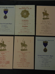
Cards - Royal Antediluvian Order of Buffaloes x8 (A - H) plus 4 (I - L), 1950's
... Centre 31 Bogong High Plains Rd Mt Beauty high-country The Royal ...The Royal Antediluvian Order of Buffaloes is an organisation that started in 1822 in the United Kingdom. It aids members, their families, dependents of former members and other charitable organisations. Membership is open to all males over the age of 18 years. The R.A.O.B. had lodges in the Kiewa Valley including Rocky Valley, Kiewa and in Tawonga as well as in nearby towns indicating that it was a popular organisation at the time. Lodge Officers are listed on each card.8 Cardboard R.A.O.B., G.A.B. Cards folded in half each with an emblem on the centre front and all with a date of meeting at the bottom. Card A - Blue from Yackandandah, Nov. 1953; Card B - Pink from Myrtleford, March 18th; Card C - Pink from Rocky Valley, July 1955; Card D - Pink from Kiewa (Foundation and Opening) Feb. 1955; Card E - Pale blue from Wodonga, Oct. 1958; Card F- Blue from Kiewa, April 1956; Card G - Blue from Rocky Valley, July 1956; Card H - Blue from Rocky Valley, May 1958. Card I-cream from Tawonga and Rocky Valley. April 1957.Card J -beige from Rocky Valley and Tawonga January 1954. Card K-Beige from Rocky Valley and Tawonga February 1956. Item L - Invitation pink December 1957 from Rocky Valley. Signatures on the invitationr.a.o.b., royal antediluvian order of buffaloes, charity organisation, lodge organisation, tawonga lodge, rocky valley lodge, kiewa valley lodges -
 Kiewa Valley Historical Society
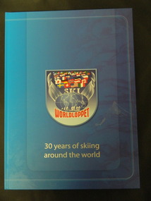
Book - Cross Country Skiing x2, Worldloppet - 30 Years of Skiing Around the World, 2007
... Centre 31 Bogong High Plains Rd Mt Beauty high-country ...The Worldloppet is a skiing race held throughout the world for cross country skiers. American Tony Wise conceived the idea of bringing together long distance skiers together. 14 ski marathons held in 4 continents (Europe, North America, Australia and Asia) with over 90,000 skiers each year.Falls Creek is on the Bogong High Plains at the top of the Kiewa Valley. Falls Creek held the first Kangaroo Hoppet in 1979 over a distance of 21 km with 80 participants. In 1995 a record 1588 participants took part. They received membership of the Worldloppet in 1991 holding the event on the last Saturday of August and haven't had to cancel the event. Two copies of a blue hard covered book with 167 pages consisting of an index (Kangaroo Hoppet page 54), information on 30 years of (cross country) skiing around the world with colored photos. cross country skiing; worldloppet; falls creek -
 Kiewa Valley Historical Society
Journal - John Creamer, Dairyfarmer, 1916 - 1942
... Centre 31 Bogong High Plains Rd Mt Beauty high-country Dairy ...Dairy farmers kept a journal to record their transactions and business on the farm. John Creamer's daughter Mary Cardwell has her father's journal covering the years 1916 to 1942.The journal was kept by local dairy farmer John Creamer who farmed at Gundowring in the Kiewa Valley. It consists of names of local people and is representative of the business (produce and life) on the dairy farm at the time.Photocopied A3 sized pages from John Creamer's dairy journal covering the years 1916-1942. The book has an alphabet index for people's names with details of their purchases (eg. mutton and potatoes) with the cost in pounds shillings and pence. Page 15 has the title "Sows When Due to Parrow" and lists the cows by name. Only pages 1 to 61 have been copied except for pages 39-41, 49, 54, 55. The rest has been digitised. See: KVHSs 1823 for digitised copydairy industry; creamer family; gundowring -
 Kiewa Valley Historical Society
Evacuation Plans for children during WWII, 1941
... Centre 31 Bogong High Plains Rd Mt Beauty high-country During ...During World War 2 the State Emergency Council for Civil Defence (Victoria) sent out forms to Municipal Councils requesting a survey to be carried out regarding the suitability of householders to accommodate persons, especially children, in the more dangerous parts of Victoria. Also, surveying parents as to their wishes regarding the evacuation of their own children if necessary. The documents list householders living in the Kiewa Valley including Gundowring giving an insight into the families (size, age, religion, sex), the homes (size, number and type of rooms), Water supply, Conveyance (motor or horse drawn), distance from railway station and school. Papers created by the State Emergency Council for Civil Defence, Premier's Department 1941 requesting Municipal Councils to survey people in case of the billeting of persons who may be evacuated from the more dangerous parts of Victoria. The Accommodation Survey lists the householder, details of the house, how many people living there and how many could be accommodated.There are also forms asking householders if they wish their children to be evacuated if necessary.Forms filled out in ink. world war ii; evacuation plans; kiewa valley; gundowring -
 Kiewa Valley Historical Society
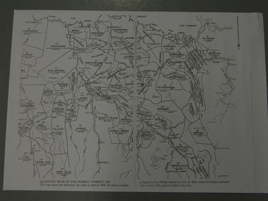
Maps - Squatting Runs of the Murray District 1848 x2, July 26,1848
... Centre 31 Bogong High Plains Rd Mt Beauty high-country The Port ...The Port Phillip Gazette was the second newspaper published in Melbourne, in the then Port Phillip district, now Victoria. In 1948 it was published bi-weekly.The map shows the original names of squatters along the Kiewa River. The names of the district are mostly current today although some are spelt differently.2 copies - 1 laminated & 1 paper of the map of "Squatting Runs of the Murray District 1848." The area is recorded (eg. Tawanga, Dederang, Gundowring, Kergunia, Merrimarenbung all along the Kiewa River) under which the names of the squatter is recorded, the number of acres and the licence number. Scale is 8 miles to the inch.squatting runs; kiewa valley; port phillip district; -
 Kiewa Valley Historical Society
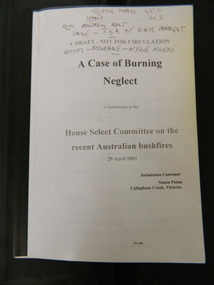
Booklet - Australian Bushfires, A Case of Burning Neglect, 2003
... Centre 31 Bogong High Plains Rd Mt Beauty high-country In early ...In early 2003 bush fires covered much of North East Victoria. Submissions were requested by the 'House Select Committee' for comment on various aspects of the fire in order to help prevent bush fires in the future.Simon Paton is a local resident of the Kiewa Valley where the bush fires occurred. His report includes other residents statements on various aspects of the fire and its prevention and impact on the local area. A booklet of 45 A4 pages with clear plastic cover bounded by black plastic spine. A Submission to the House select Committee on the recent Australian bushfires 29 April 2003. Submission Convenor: Simon Paton, Callaghans Creek, VictoriaThroughout in black pen markings and notes.2003 bush fires; north east victoria -
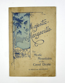 Marysville & District Historical Society
Booklet, Marysville Tourist Association, Magestic Marysville-The Mystic Mountains of the Great Divide, 1920's
An information guide of day trips to attractions in and around Marysville in Victoria. This booklet was produced by the Marysville Tourist Association.Paperback. Cover is beige with a drawing of two people standing next to a car looking at the view. The title is in dark blue across the front.non-fictionAn information guide of day trips to attractions in and around Marysville in Victoria. This booklet was produced by the Marysville Tourist Association.marysville, victoria, marysville tourise association, steavenson falls, keppel falls, cameron cascades, cumberland, mt cathedral, eildon, snob's creek falls, wolfram mine, mt strickland, keppel's lookout, mt kitchener, mt edgar, mt gordon, nichol's lookout, michael dene, beauty spot, gilbert's gully, taggerty river, wood's point -
 Marysville & District Historical Society
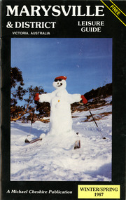
Booklet (Item) - Leisure guide, Michael Chesire & Associates Pty. Ltd, MARYSVILLE & DISTRICT LEISURE GUIDE-WINTER/SPRING 1987, 1987
A free leisure guide to Marysville and the surrounding district published for Winter and Spring, 1987. This was produced by Michael Cheshire as a free publication to promote tourism in Marysville and the surrounding district. It includes maps of the Big River Valley, Cumberland Valley, Lady Talbot Forest Drive, the Marysville area, and the township of Marysville. It was released in the winter of 1987. A free leisure guide to Marysville and the surrounding district published for Winter and Spring, 1987.marysville, victoria, australia, leisure guide, michael cheshire & associates pty ltd, marysville golf club, blackwood lodges, sir colin mackenzie fauna park, lake eildon, fraser national park, yarra valley wineries, marysville coach tours, kooringa, marylands guest house, lady talbot forest drive, wishing well, taggerty river recreation area, athols abbey, phantom falls, keppel falls, the beeches walking track, marylyn guest house, kufstein inn motel, the cumberland, marysville tourist & progress association, marysville newsagency & general store, crossways restaurant & motel, beauty spot walk, tree fern gully walk, michaeldene track, keppel track, woods lookout track, marysville hotel motel, lake mountain ski hire, marysville recreation and fun park, mytanta horseback safaris, upper big river valley, the big culvert, marysville mountain view horse hire, maryton park, amber view holiday lodges, cathedral restaurant, the top shop, tower motel, menzes garage, marysville ski hire, lake mountain ski school, faraway forest, scenic motel, buxton trout farm, marysville hardware, timbertop steakhouse, marysville trout farm, healesville sanctuary, buxton hotel motel, nanda binya lodge, buxton antique and furniture mart, the black spur inn hotel, alexandra, lake mountain, j l gould sawmills pty. ltd., geoffrey pope & associates, marysville crafts & gifts, olde yarra track shoppe, cumberland scenic reserve, tudor lodge road house, fruit salad farm, highwayman's retreat, beauty spot display gardens & nursery, ski lake mountain cross country ski hire & kitchen, buxton store, valley view marysville, acheron way, mt donna buang road, snow gum woodlands, alpine ash forests, mountain ash forests, stringybark forests, messmate forests, manna gum forests -
 Lorne Historical Society
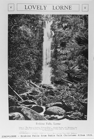
Pamphlet - Tourist Brochure, Lovely Lorne
The Victorian Railways promoted tourist destinations around Victoria. A folded paper tourist brochure about Lorne The front cover is a coloured painting of Lorne from above the Erskine River towards the main beach. , on the back is a black and white sketch tourist map of the roads, tracks and beauty spots. Inside the first fold are 6 black and white photographs, Cumberland River, Mt St George, Phantom Falls, Cumberland Cliffs, Teddy’s Lookout, leafy walk towards the pier. Inside contains written descriptions of the highlights of Lorne and six black and white photographs, four general views of Lorne, Lover’s Walk, Erskine Falls . souvenirs, victorian railways, publicity -
 Kiewa Valley Historical Society
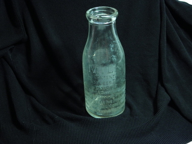
Bottle - Milk, circa early 1900s
... Centre 31 Bogong High Plains Rd Mt Beauty high-country ...This bottle was manufactured for the Lady Talbot Milk Institute. The Institute was initiated circa 1900 by Lady Talbot wife of Sir Reginald Arthur James Talbot, Governor of Victoria (1904 to 1908). From 1908 the Lady Talbot Milk Institute provided "pure" unpasteurized cows milk to specific mothers throughout Victoria. Similar bottles were filled with Specially Supervised "Nursery Milk". The reason for establishing this specialised nursing milk was to reduce the high mortality rate of infants(not on breast milk) in the early 1900s due to contaminated milk supplies. Pasteurized milk became available after World War II which ensured that milk consumed by infants (not able to obtain breast milk) was free from any contaminants. Bottled milk distributed by the Lady Talbot Milk Institute was used by specific mothers of infants in lieu of breast milk. As this requirement was throughout Victoria some nursing mothers within the Kiewa Valley and in the SEC Company town of Mount Beauty needing this service were covered. The establishment(Circa 2000) of breast milk supply from donor mothers throughout Australia has replaced the fundamental product initiated by the Talbot Milk Institute. The slogan "Breast is best" initiated by the Nursing Mothers Association is one of the major supporters of the mother's milk bank supplies.One pint wide necked refillable glass milk bottle. Chipped rim and base. Side 1 MILK Embossed Contents Not less than One Pint (This bottle cannot be legally used or sold by others) This bottle is the property of the Caulfield Model Farm To be washed and returned Side 2 Embossed circular logo with a cross in the centre Surrounded by brand name Lady Talbot Milk Institute Specially Supervised Nursery Milk Base, 62lady talbot milk institute, glass milk bottle, caulfield model farm, bresat milk substitute -
 Kiewa Valley Historical Society
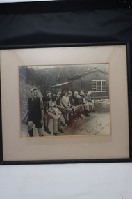
Photo Framed, Bogong School 1944, October 1944
... Centre 31 Bogong High Plains Rd Mt Beauty high-country Photo ...Photo of the first 13 children enrolled at Bogong SchoolHistorical record of Bogong School life in 1944 History of Kiewa Hydro SchemeA rectangle framed sepia photo of 13 children seated outside Bogong School dated October 1944To Bogong School with best wishes from Thomas Wood taken Oct 1944bogong school photo 1944, education, school, kiewa hydro scheme -
 Kiewa Valley Historical Society
Postcard Circa 1950, Lake Guy Dam and Bogong Village, Circa 1950
... Centre 31 Bogong High Plains Rd Mt Beauty high-country ...This postcard was produced in the 1950's for the tourist trade in the Kiewa Valley and Alpine region. It encompasses the period when the State of Victoria was pressured by the ever increasing demand by industry and its population for electricity supplies. Hydro electricity was seen as an untapped natural resource to quench this demand. The Victorian Alps and the rivers flowing into its valleys was ideal for the construction of the Kiewa Hydro Electricity Scheme. The late 1940's saw the development of this scheme and the changing of sections of alpine landscape is covered by this and other postcards/pictures (tourists, construction workers, and established rural populations). This period in time was before the established wildlife and forest/nature groups became political activist who changed legislative acts to protect the environment.This rural region (Kiewa Valley/alpine plains) was at most only significant to a smaller group of winter sports, summer hikers/horse riders and rural farmers/graziers. The numbers of tourists and the increase in the local resident population was boosted by the construction of the Hydro Electricity Scheme. This influx to the regional population resulted in a corresponding diversity in services and brought about an environment that responded to a growing level of tourists and thereby permitting this industry to grow more rapidly than it would have naturally. This postcard details an attraction to the "cleaner" method of providing electricity. This postcard was purchased in 1950 by a surveyor at Landford's Gap.This black and white photograph from a Valentine's postcard is from a V2 Argus photograph postcard. It is on a 200g/m paper density photo side gloss. See 0480 (B) - (F) for other photos of similar postcards.In white lettering " LAKE GUY & BOGONG VILLAGE KIEWA HYDRO-ELECTRIC PROJECT"kiewa valley tourism, victorian alps, alternate energy supplies, alpine population growth -
 Kiewa Valley Historical Society
Postcard Circa 1950, Snowfall at Bogong Village Kiewa Hydro-Electric Project, 1950s
... Centre 31 Bogong High Plains Rd Mt Beauty high-country ...This postcard was produced in the 1950's for the tourist trade in the Kiewa Valley and Alpine region. It encompasses the period when the State of Victoria was pressured by the ever increasing demand by industry and its population for electricity supplies. Hydro electricity was seen as an untapped natural resource to quench this demand. The Victorian Alps and the rivers flowing into its valleys was ideal for the construction of the Kiewa Hydro Electricity Scheme. The late 1940's saw the development of this scheme and the changing of sections of alpine landscape is covered by this and other postcards/pictures (tourists, construction workers, and established rural populations). This period in time was before the established wildlife and forest/nature groups became political activist who changed legislative acts to protect the environment.This rural region (Kiewa Valley/alpine plains) was at most only significant to a smaller group of winter sports, summer hikers/horse riders and rural farmers/graziers. The numbers of tourists and the increase in the local resident population was boosted by the construction of the Hydro Electricity Scheme. This influx to the regional population resulted in a corresponding diversity in services and brought about an environment that responded to a growing level of tourists and thereby permitting this industry to grow more rapidly than it would have naturally. This postcard details an attraction to the "cleaner" method of providing electricity. This postcard was purchased in 1950 by a surveyor at Landford's Gap.This scanned black and white photograph of a postcard, shows vehicles covered in thick snow at Bogong Village in 1950. See 0480(A), (C) - (F) for other similar photos of postcards available at this period."SNOWFALL AT BOGONG VILLAGE KIEWA HYDRO-ELECTRICITY PROJECT"kiewa valley tourism, victorian alps, alternate energy supplies, alpine population growth, bogong village, secv -
 Kiewa Valley Historical Society
Postcard Circa 1950, Scene in Bogong Village Kiewa Hydro-Electric Project, 1950s
... Centre 31 Bogong High Plains Rd Mt Beauty high-country ...This postcard was produced in the 1950's for the tourist trade in the Kiewa Valley and Alpine region. It encompasses the period when the State of Victoria was pressured by the ever increasing demand by industry and its population for electricity supplies. Hydro electricity was seen as an untapped natural resource to quench this demand. The Victorian Alps and the rivers flowing into its valleys was ideal for the construction of the Kiewa Hydro Electricity Scheme. The late 1940's saw the development of this scheme and the changing of sections of alpine landscape is covered by this and other postcards/pictures (tourists, construction workers, and established rural populations). This period in time was before the established wildlife and forest/nature groups became political activist who changed legislative acts to protect the environment. This rural region (Kiewa Valley/alpine plains) was at most only significant to a smaller group of winter sports, summer hikers/horse riders and rural farmers/graziers. The numbers of tourists and the increase in the local resident population was boosted by the construction of the Hydro Electricity Scheme. This influx to the regional population resulted in a corresponding diversity in services and brought about an environment that responded to a growing level of tourists and thereby permitting this industry to grow more rapidly than it would have naturally. This postcard details an attraction to the "cleaner" method of providing electricity. This postcard was purchased in 1950 by a surveyor at Landford's Gap. The couple shown in this photograph would have been employed by the S.E.C. under the Kiewa Hydro-Electricity Scheme.This item is a scanned black and white photograph of a couple walking along a gravel street in Bogong Village in 1950. See 0480 (A) ,(B), (D) - (F) for other photos of similar postcards" SCENE IN BOGONG VILLAGE KIEWA HYDRO-ELECTRIC PROJECT"kiewa valley tourism, victorian alps, alternate energy supplies, alpine population growth, bogong, secv -
 Kiewa Valley Historical Society
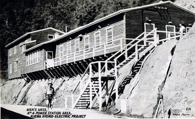
Postcard Circa 1950, Men's Mess No.4 Power Station, Kiewa Hydro-Electric Project
... Centre 31 Bogong High Plains Rd Mt Beauty high-country ...This postcard was produced in the 1950's for the tourist trade in the Kiewa Valley and Alpine region. It encompasses the period when the State of Victoria was pressured by the ever increasing demand by industry and its population for electricity supplies. Hydro electricity was seen as an untapped natural resource to quench this demand. The Victorian Alps and the rivers flowing into its valleys was ideal for the construction of the Kiewa Hydro Electricity Scheme. The late 1940's saw the development of this scheme and the changing of sections of alpine landscape is covered by this and other postcards/pictures (tourists, construction workers, and established rural populations). This period in time was before the established wildlife and forest/nature groups became political activist who changed legislative acts to protect the environment.Although this photo details the eating facilities of the construction workers at the power station it was not only a postcard for the people employed in the Hydro Scheme is was also provided to tourists visiting the area and thus used for promotional purposes.This rural region (Kiewa Valley/alpine plains) was at most only significant to a smaller group of winter sports, summer hikers/horse riders and rural farmers/graziers. The numbers of tourists and the increase in the local resident population was boosted by the construction of the Hydro Electricity Scheme. This influx to the regional population resulted in a corresponding diversity in services and brought about an environment that responded to a growing level of tourists and thereby permitting this industry to grow more rapidly than it would have naturally. This postcard details an attraction to the "cleaner" method of providing electricity. This postcard was purchased in 1950 by a surveyor at Landford's Gap. The men shown in this photograph would have been employed by the S.E.C. under the Kiewa Hydro-Electricity Scheme.This item is a scanned black and white photograph of a construction worker walking from stairs leading down from the men's mess building, in 1950. See 0480 (A) -(C), (E) - (F) for other photos of similar postcards"MEN'S MESS No.4 POWER STATION AREA, KIEWA HYDRO-ELECTRIC PROJECT" "ARGUS PHOTO V.IIkiewa valley tourism, victorian alps, alternate energy supplies, alpine population growth, secv -
 Kiewa Valley Historical Society
Postcard Circa 1950, Howman Gap Hostel under snow Kiewa Hydro-Electric Project, Circa 1950
... Centre 31 Bogong High Plains Rd Mt Beauty high-country ...This postcard was produced in the 1950's for the tourist trade in the Kiewa Valley and Alpine region. It encompasses the period when the State of Victoria was pressured by the ever increasing demand by industry and its population for electricity supplies. Hydro electricity was seen as an untapped natural resource to quench this demand. The Victorian Alps and the rivers flowing into its valleys was ideal for the construction of the Kiewa Hydro Electricity Scheme. The late 1940's saw the development of this scheme and the changing of sections of alpine landscape is covered by this and other postcards/pictures (tourists, construction workers, and established rural populations). This period in time was before the established wildlife and forest/nature groups became political activist who changed legislative acts to protect the environment.This rural region (Kiewa Valley/alpine plains) was at most only significant to a smaller group of winter sports, summer hikers/horse riders and rural farmers/graziers. The numbers of tourists and the increase in the local resident population was boosted by the construction of the Hydro Electricity Scheme. This influx to the regional population resulted in a corresponding diversity in services and brought about an environment that responded to a growing level of tourists and thereby permitting this industry to grow more rapidly than it would have naturally. This postcard details an attraction to the "cleaner" method of providing electricity. This postcard was purchased in 1950 by a surveyor at Landford's Gap.This item is a scanned black and white photograph of a panoramic view of Howman Gap Hostel under snow in 1950 (a closed village, entry by pass only). This accommodation was for construction workers only. See 0480 (A) -(E) for other photos of similar postcards.On the photo, " Howman Gap Hostel under snow Kiewa Hydro-Electric Project" . On postcard address and personal information side "V.2 Valentine's Post Card "kiewa valley tourism, victorian alps, alternate energy supplies, alpine population growth, bogong, secv, howman's gap hostel -
 Kiewa Valley Historical Society
Photograph Farm Land, Mount Beauty Acreage before Golf Course, Circa 1950
... Centre 31 Bogong High Plains Rd Mt Beauty high-country ...This photograph is a "snap shot" in time circa 1950s detailing the rural environment before the effects of the Kiewa Valley Hydro Scheme altered the basic rural setting of the valley. The golfing fairway was being mapped out on previous grazing land, before the laying of a golf course, for use by the construction workers and auxiliary administration employees of the Victorian State Electricity Commission. This photograph details a dramatic period in time which saw an enormous change to the exclusively rural area of the Kiewa Valley region in the mid 1900s. This change presented both physical and mental challenges to the existing quiet rural inhabitants of the valley. The State of Victoria had to make adjustments to the changing demands imposed by population and industrial expansions. The development of cleaner energy supplies to a growing population has its downside ,which ever way the intrusion into the "natural" landscape is made.Black and white photograph detailing surveyor posts for construction of golf course. Land used, before establishment of the Mount Beauty Village, as farming/grazing cattle and viewed towards Mount Bogong and its Alpine ranges. The photo is on 200gms paper and not on photographic paper.nilmount beauty in the 1940s - 1950s, grazing in the kiewa valley, sec victoria -
 Kiewa Valley Historical Society
Photograph from Lake Guy, Bogong Village, Scene from shores of Lake Guy to Mountain range, 1930s to 1950s
... Centre 31 Bogong High Plains Rd Mt Beauty high-country In 1940 ...In 1940 Field Headquarters for the Kiewa Scheme were established at Bogong with office, workshop facilities and accommodation for workmen, staff and some families constructed. (There had been a 'tent camp' on this site in 1939 but was destroyed by bushfires) Construction of accommodation continued until 1947. A total of 40 houses plus a hostel for single staff, post office, police station, medical centre and primary school all with water and sewerage and electricity supply. The staff hostel was known as Kiewa House and is now occupied by the Education Department. Lake Guy was named after Mr. L.T. Guy who was the Resident Engineer in charge of construction work and associated activities on the Kiewa area. He held this position from 1939 to November 1946 when he was transferred to Head Office.The Bogong Township was developed firstly as an accommodation centre (base camp) for construction workers employed under the Kiewa Hydroelectric Scheme. Due to the influx of European workers into the Township the beautification of the immediate surrounds(gardens etc.) had a distinct European flavour. This environment has been very beneficial for tourism in later years. Strict environmental control has not allowed for any extensive redevelopment in tourist accommodation and basically restricted it to the accommodation initially built for the construction workers. Activities such a bike riding, snow skiing, restricted horse riding and bush walking on the Alpine plains and mountains are now a viable part of the Kiewa Valley Tourist Industry. The lake is one of the many water storage storage reservoirs used to supply the power stations their main power to run the huge turbines generating the final product, electricityThis black and white photograph shot from the shores of Lake Guy toward the mountain range of the Victorian Alps details the early construction of the construction worker's accommodation of the Bogong Village. The paper is of 200gms and is not photographic paper and can be assumed to be a reproduction of an original photobogong village circa 1930 to 1950, kiewa hydro-electricity scheme, victorian alpine region mid 1900s -
 Kiewa Valley Historical Society
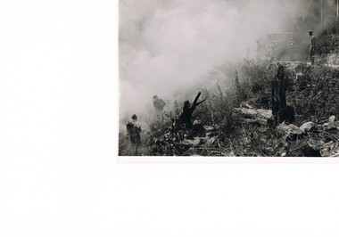
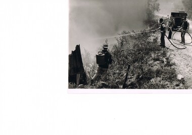
Photograph Fire Prevention Victorian Alps, Burning, Circa 1950
... Centre 31 Bogong High Plains Rd Mt Beauty high-country ...This photograph, in late 1950s, shows an Alpine Fire Prevention technique of "burning off" low levels of scrub to reduce the level of available fuel against any possible summer bush fires. The Alpine regions accumulate high levels of potential fuel (undergrowth and small shrubs) which if not reduced has the potential of breaking into a dangerous bush fire. The men in this photograph are not wearing any protective clothing. Their visibility to other firefighters is severely reduced by smoke. This photo is a snap shot in time when Occupational Health and Safety Legislation was in its infancy stage.This photograph details the fire prevention activities in the Victorian Alps under the management of the SEC Victoria. The level of undergrowth within the Australian bush needs to be kept under control to avoid the possibility of lightning strikes (during summer storms) igniting dry forests resulting in a major bush fire. Controlled fires within alpine regions are required not only to reduce the level of dry undergrowth but also to provide those various plant species requiring fire for regenerate. This method was used by the original inhabitants (Aborigines) as limited scrub fires were used to flush game and bird population for eating with the side benefit to those plants requiring the fire for regeneration.This black and white photograph shows an Alpine Fire Prevention technique of "burning off" low levels of scrub. The photograph is on 200gsm paper but it is not photographic paper. It can be assumed that the photo is not the original but a copy. alpine fire prevention, sec fire prevention -
 Kiewa Valley Historical Society
Photograph Fire Prevention Victorian Alps, Burning, Circa 1950
... Centre 31 Bogong High Plains Rd Mt Beauty high-country ...This photograph, from the 1950s, shows an Alpine Fire Prevention technique of "burning off" low levels of scrub to reduce the level of available fuel against any possible summer bush fires.The Alpine regions accumulate high levels of potential fuel (undergrowth and small shrubs) which if not reduced has the potential of breaking into a dangerous bush fire. The men in this photograph are not wearing any protective clothing. Their visibility to other firefighters is severely reduced by smoke. This photo is a snap shot in time when Occupational Health and Safety Legislation was in its infancy stage.This photograph details the fire prevention activities in the Victorian Alps under the management of the SEC Victoria. The level of undergrowth within the Australian bush needs to be under control to avoid the possibility of lightning strikes (during summer storms) igniting dry forests resulting in a major bush fire. Controlled fires within alpine regions are required not only to reduce the level of dry undergrowth but also to provide those various plant species requiring fire for regenerate. This method was used by the original inhabitants (Aborigines) as limited scrub fires were used to flush game and bird population for eating with the side benefit to those plants requiring that fire for regeneration.This black and white photograph shows an Alpine Fire Prevention technique of "burning off" low levels of scrub. The photograph is on 200gsm paper but it is not photographic paper. It can be assumed that the photo is not the original but a copy produced by the SEC Vic. See also KVHS 0413 and KVHS 0414 for other similar photos.kiewa valley tourism, victorian alps, alternate energy supplies, alpine population growth -
 Kiewa Valley Historical Society
Photograph Fire Prevention Victorian Alps, Burning, Circa 1950
... Centre 31 Bogong High Plains Rd Mt Beauty high-country ...This photograph, in late 1950s, shows an Alpine Fire Prevention technique of "burning off" low levels of scrub to reduce the level of available fuel against any possible summer bush fires. The Alpine regions accumulate high levels of potential fuel (undergrowth and small shrubs) which if not reduced has the potential of breaking into a dangerous bush fire. The men in this photograph are not wearing any protective clothing. Their visibility to other firefighters is severely reduced by smoke. This photo is a snap shot in time when Occupational Health and Safety Legislation was in its infancy stage.This photograph details the fire prevention activities in the Victorian Alps under the management of the SEC Victoria. The level of undergrowth within the Australian bush needs to be kept under control to avoid the possibility of lightning strikes (during summer storms) igniting dry forests resulting in a major bush fire. Controlled fires within alpine regions are required not only to reduce the level of dry undergrowth but also to provide those various plant species requiring fire for regenerate. This method was used by the original inhabitants (Aborigines) as limited scrub fires were used to flush game and bird population for food, with a side benefit to those plants requiring the fire for regeneration.This black and white photograph shows an Alpine Fire Prevention technique of "burning off" low levels of scrub. The photograph is on 200gsm paper but it is not photographic paper. It can be assumed that the photo is not the original but a copy. See also KVHS 0413 and KVHS 0415 for other similar photos.kiewa valley tourism, victorian alps, alternate energy supplies, alpine population growth -
 Kiewa Valley Historical Society
Photograph of Kiewa Valley Panorama, Farming lands within the Kiewa Valley in1950s, Circa 1950
... Centre 31 Bogong High Plains Rd Mt Beauty high-country ...This photograph shows how (early to mid1900s), before the establishment of the Mount Beauty "gated" village, the Kiewa Valley was farmed and the scarce population was spread out over acres of productive land. This photograph catches a time before (what appeared to the local farmers as the invasion by a mass of construction workers) when this remote valley was part of a "lay back" rural landscape,occasionally visited by friends and some wayward tourists. The mountain ranges provided an adequate barrier against the way-would traveller. The immigration numbers coming into Australia was still quite small ( due to the "white" Australia policy) which was in force before World War II. After World War II a mass of displaced European refugees and migrants boosted the Australian population and provided for a greater degree of diverse professions and rural related work force.This photograph depicts the borderline in time between an exclusively rural based population and respective activities(early 1900s)to the present (2000 on wards) integrated village, tourist and retiree/holiday area. The time when land was exclusively used in agriculture is over and the impact of cheaper rural produce from Asian markets will see a shift of land useage and population activities. The Kiewa Valley is loosing its hiding place and is becoming more and more a source of untapped residential land. Black and white photograph of farming/grazing land useage, before the establishment of the Mount Beauty Village. Small pockets of residentual houses can be viewed. Road access (unsealed dirt) was typical of that provided in rural regions in the 1950s. The photo is on 200gms paper and not on photographic paper.kiewa valley in the early1900s, grazing in the kiewa valley, sec victoria -
 Kiewa Valley Historical Society
Photograph of Snow Covered Catchment Area Vic, Snow Covered Catchment Area Victorian Alps - 1950s, Circa 1950
... Centre 31 Bogong High Plains Rd Mt Beauty high-country ...This photograph details (early to mid1950s), the Victorian Alpine region when this remote area was part of a "lay back" rural landscape,occasionally visited by recreational adventurers and some wayward tourists. The mountain ranges had provided an adequate barrier against the way-would traveller, but with the opening up of this region by the provision of improved roadways and accommodation facilities, courtesy of the Kiewa Valley Hydro Electricity Scheme, changes such as tourism and its impact upon the "natural" state started to show its side effects (clearing of the land). The expansion of the European immigration numbers (1950s) coming into Australia was increasing after World War II which not only provided increased construction workers to the region but also immigrants who appreciated alpine regions. Some of these immigrants contributed to the expansion of the region and provided for a greater degree of diverse professions and rural related work force.This photograph depicts the borderline in time between an exclusively rural based population and respective activities(early 1900s)to the present (2000 on wards) integrated village, tourist and retiree/holiday area. The time when land was exclusively used in agriculture and Alpine grazing lands is over. The Kiewa Valley is loosing its hiding place and is becoming more and more a source of untapped residential land and winter time recreational adventure lands. The changes brought about by modern technologies involving recreational activities such as hang gliding, gliding (local airstrip), mountain bikes, car rallies and their associated clubs is providing for an increased short term population boost. These together with the attractions for retirees is changing not only the physical nature of the Kiewa valley but also its "soul".This item is a black and white photograph of a section of snow covered catchment area in the Victorian Alps in the mid 1900. It is on 200 gms paper but not on photographic paper and has a white boarder (3 mm).kiewa valley tourism, victorian alps, alternate energy supplies, alpine population growth -
 Kiewa Valley Historical Society
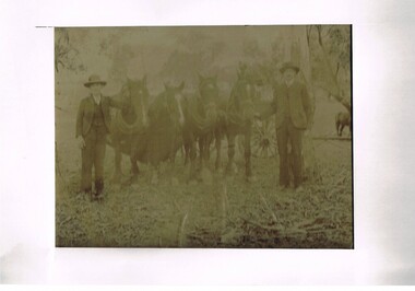
Photograph (Digital) Harnessing Horses, Harnessing Working Horses early 1900, early 1900s
... Centre 31 Bogong High Plains Rd Mt Beauty high-country This copy ...This copy of an original photograph created in the early 1900s details the "horse and cart" era when the normal transportation of the day was, in this rural setting, exclusively by horse and cart. The importance of this particular photograph to the subjects can be seen by the formal suits worn by both subjects.The natural bush and grassed backdrop have not been "touched up". The dray behind the horses is barely visible (fog like aperture). The lad , John Cooper was 14 years old when this photograph was taken. Both were in the process of harnessing four horses to "hook up" on the dray behind them. From their attire it looks like a trip to town or "the church".This photograph of life on a rural property in the early 1900 shows the rough and hard (physically) life in rural areas before great mechanical revolution/evolution post World War II. This was a time in the Kiewa Valley when most transportation was by horse drawn carriages and transportation routes where dirt roads with potholes. The significance of a local pioneer "family" encapsulated by this photograph cannot be reproduced as effectively in any other form. This digitised scanned copy of an original photograph of four work horses is on 200gms Fujicolor (Fujifilm) Crystal Archive paper has a silver side on which the image has been printed and a matt reverse side.The darker slightly "blurred" image has had a white frame placed over it at the time of encapsulation to provide the finished photo with a frame. This method highlights and focuses the view into the photograph. It is a clever way to permit the eyes to focus into the image to give it a greater third dimensional aspect. on the reverse side hand written(in pencil) "John Cooper & Paddy Cullen (itinerant worker) on grandfathers place (opposite Nesta Drews place) (orange Grove). "Grandfather emigrated from England with Ryders""orange grove " property, early tawonga life style, john cooper, paddy cullen, harnessing working horses