Showing 1102 items matching "north-east victoria"
-
 Ballarat Tramway Museum
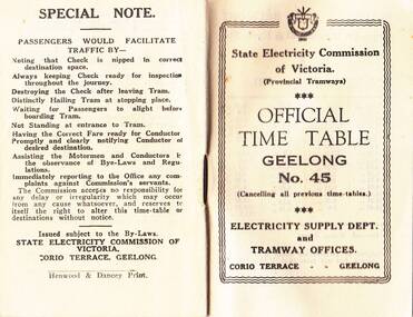
Photograph - Digital image, State Electricity Commission of Victoria (SECV), "Official Timetable Geelong No. 45"
Digital image or copy of the SEC "Official Timetable Geelong No. 45", 16 image files - 32 pages, giving details of the fares, transfers, luggage or parcels, lost property, times of each tram on the Belmont (1), Chilwell (2), East Geelong (3), Eastern Park (4), Newtown (5), North (6), West Geelong (7). Gives details of railway station trams, transfer ticket arrangements, depot workings and the night signs carried out each tram. Based on the 4d max fare, it is a circa 1949 timetable - see reference. See also Reg Item 5629 for Timetable No. 39, c1943 and 8552 for a photocopy of No. 47, March 1953 and 9821 for a photocopy of No. 46. See BTM document, "SEC fare changes - by law references etc.doc, dated 3/9/2006.trams, tramways, geelong, timetables -
 Ringwood and District Historical Society
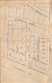
Map - Subdivision Plans, Residential allotments in Canterbury Road, Hume Street, Finlayson Street, Gray Street (later Grayview Avenue), and Thomas Street (later Gracedale Avenue), Ringwood East, Victoria - (Undated - circa 1950s)
Hand-drawn map on light cardboard backing. Multiple sets of numbered allotments, with un-numbered lots adjoining a drainage reserve north of Finlayson Street. -
 Monbulk RSL Sub Branch
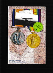
Book, Bruce Anderson, Ploughshares and propellers, 2008
The Australian Flying Corps (AFC), RAAF and WAAAF have attracted into their ranks many young men and women from the old Shires of Kerang, Cohuna, East Loddon and Gordon in north central Victoria and Wakool in the western Riverina district of New South Wales. This book tells some of their stories and exploits from 1914-1918, 1939-1945 and onwards to the 1990s.Ill, p.560.non-fictionThe Australian Flying Corps (AFC), RAAF and WAAAF have attracted into their ranks many young men and women from the old Shires of Kerang, Cohuna, East Loddon and Gordon in north central Victoria and Wakool in the western Riverina district of New South Wales. This book tells some of their stories and exploits from 1914-1918, 1939-1945 and onwards to the 1990s. royal australian air force - history, royal australian air force - biographies -
 Marysville & District Historical Society
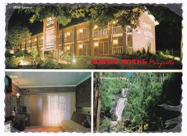
Postcard (item) - Colour postcard, Nucolorvue Productions Pty. Ltd, TOWER MOTEL Marysville, Unknown
A colour postcard from the Tower Motel in Marysville. The postcard was published by Nucolorvue as a souvenir of Marysville. The Tower Motel was one of the few buildings in Marysville that survived the 2009 Black Saturday bushfires.A colour postcard from the Tower Motel in Marysville. The postcard was published by Nucolorvue as a souvenir of Marysville.A/ NU-COLOR-VUE/ OF/ AUSTRALIA PLACE/ STAMP/ HERE POST CARD Product of Australia RP66 NUCOLORVUE PRODUCTIONS PTY. LTD./ COPYRIGHT TOWER MOTEL/ Murchison St., Marysville, Vic./ Phone (059) 63 3225 New luxury Motel, 100 km north/ east of Melbourne in the heart of/ the big timber country - just a/ short drive from the magnificent/ floodlit Steavenson's Falls - the/ tallest in Victoria. Units equipped with all modern/ facilities, including colour T.V. and/ air conditioning.marysville, victoria, australia, tower motel, accommodation, postcard, souvenir, nucolorvue productions pty. ltd., 2009 black saturday bushfires -
 Marysville & District Historical Society
Postcard (item) - Colour postcard, Nucolorvue Productions Pty. Ltd, TOWER MOTEL Marysville, Unknown
A colour postcard from the Tower Motel in Marysville. The postcard was published by Nucolorvue as a souvenir of Marysville. The Tower Motel was one of the few buildings in Marysville that survived the 2009 Black Saturday bushfires.A colour postcard from the Tower Motel in Marysville. The postcard was published by Nucolorvue as a souvenir of Marysville.A/ NU-COLOR-VUE/ OF/ AUSTRALIA PLACE/ STAMP/ HERE POST CARD Product of Australia RP66 NUCOLORVUE PRODUCTIONS PTY. LTD./ COPYRIGHT TOWER MOTEL/ Murchison St., Marysville, Vic./ Phone (059) 63 3225 New luxury Motel, 100 km north/ east of Melbourne in the heart of/ the big timber country - just a/ short drive from the magnificent/ floodlit Steavenson's Falls - the/ tallest in Victoria. Units equipped with all modern/ facilities, including colour T.V. and/ air conditioning.marysville, victoria, australia, tower motel, accommodation, postcard, souvenir, nucolorvue productions pty. ltd., 2009 black saturday bushfires -
 Bendigo Historical Society Inc.
Document - NEW CHUM LINE OF REEF - REFERENCE TO CALEB THOMAS PLANS
Five pages of reference numbers used on Caleb Thomas plans. Has the mine's name, size of shaft and on other pages, the height of the sill. One mine on the Sheepshead Line, the New St Mungo is mentioned. Many mines along the reef are mentioned.document, gold, mines, new chum line of reef, reference to caleb thomas plans, catherine reef extd., new franklin, murchison, catherine reef united, catherine reef (south), acadia catherine, william's united, york & durham, belmont & saxby, ellenborough, sadowa, (old) st mungo, lady barkly, princess alice (sth st mungo), unicorn trib, pheonix, hopewell, united devonshire (princess alex), west united devonshire, east united devonshire, duchess of edinburgh, south devonshire, duchess tribute, new st mungo, new st mungo, new vict catherine, gt extd vict, herc new chum (late pearl), pearl south, north herc & energetic, herc & energetic, ironbark, vict consols, south new chum, lansell's 616, south belle vue, eureka extd, new chum rly, south old chum, new chum consolidated, ellesmere (south shaft), garibaldi, cravens, young chum, ellesmere nth shaft, new chum united, new chum vic, old chum, lazarus, cent new chum, lansell's 222, north old chum, lansell's big 180, advents advance, gt cent vict, hamboldt, ballerstedt, victoria quartz, herc & energetic, herc (old), shenandoah, victoria reef gold, victoria consols -
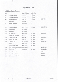
 Ringwood and District Historical Society
Drawing - Plan of Subdivision of Crown Allotment 42, Section C, Ringwood, Vic (Undated), Hand-drawn outline of residential allotments in Dublin Road north of Alexandra Road, Ringwood East, Victoria
Pen drawing on cardboard backing. -
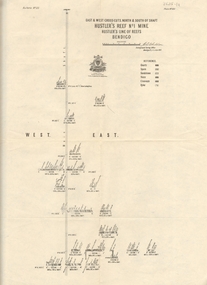
 Bendigo Historical Society Inc.
Map - HUSTLER'S REEF MINE - EAST & WEST CROSS-CUTS, NORTH & SOUTH OF SHAFT
East & West Crosscuts, North & South of Shaft, Hustler's Reef Mine Bulletin No 33, Plate No XIX. Map shows main shaft and smaller drawing of section with different stone encountered. Also gives location in relation to the shaft, e. g. 225'E & 150'S of Shaft. Reference diagram to show the different stone and features encountered. Geological Survey of Victoria emblem. Signed by H A Whitelaw, Underground Survey Office Bendigo, September 1913. mining, parish map, hustler's reef mine, east & west cross-cuts north & south of shaft, geological survey of victoria, h a whitelaw, underground survey office bendigo -
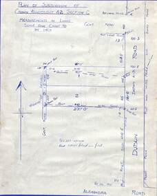
 Ringwood and District Historical Society
Map, Subdivision Plan - 8 residential allotments south of City Road on Wantirna Road, Ringwood, Victoria - (Undated - circa 1950s)
Hand-drawn map on cardboard backing.Part of Crown Portion 11, Parish of Ringwood, County of Bourke. Some allotments include real estate sales notations. (North arrow incorrectly points east.) -
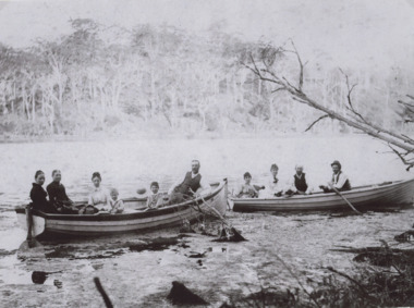 Lakes Entrance Historical Society
Photograph, Carpenter family, 1989
named are George Alfred Carpenter and sons Lionel 5 years and John Basil 4 years old seated in two rowing boats on a waterway which appears to be North Arm Lakes Entrance Victoria. The second and third phto are of George Carpenters house in BairnsdaleSepia toned photograph of eight adults and two young boys in boats including members of the Carpenter family . Also two other photos In the third photo "George Carpenters old home 'Thelma' East Bairnsdaslegenealogy, waterways, boats -
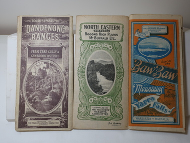 Kiewa Valley Historical Society
Maps - Tourist
... was spelt Towonga. North East Victoria in 1933 was before ...These maps were all dated 1933 which was before the construction of the Kiewa Hydro Electric Scheme and when Tawonga was spelt Towonga. North East Victoria in 1933 was before the construction of the Kiewa Hydro Electric Scheme so the townships of Mt Beauty and Bogong are not shown. The description of the Snow Lines was important as skiers, bushwalkers and campers relied on them. The details on the map include "ADB. Numbered from A.1-377 round plates. CD Numbered from C 1-235 square plates. Poles about 3 chains apart 27 to the mile." 3 Tourist location maps (folded) and printed on parchment. 1. Tourist map of the Dandenong Ranges. Brown cover. dated 6-4-33. Govt. printer showing roads, tracks in red and heights of the land. 2. Tourist Map of Warburton, Mt Baw Baw, and Walhalla. Blue and Orange cover. dated 23-5-33 Govt. printer. 3 different maps of each area showin roads, tracks and timber tramways.Also in red and blue. 3. Tourist Map of North Eastern Victoria including Bogong High Plains Mt Buffalo Etc. Green cover. dated June 1933 Govt. printer. Main map and insert titled Bogong High Plains. Showing roads , tracks and tram ways. On insert showing snow poles. Also Red and Blue and mountains.By Authority of H.J. Green - 6 pence. Dept of Lands and Survey, Melbourne1933 maps, tourism maps, bogong high plains map 1933, snow poles -
 Falls Creek Historical Society
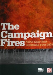
Book - The Campaign Fires - North-East/East Gippsland Fires 2003, Lyndel Hunter
... to the 2003 bushfires in Victoria. The Campaign Fires - North-East ...A description of efforts to fight the bushfires in Gippsland in 2003, including maps and illustrations. This volume was published as a tribute to the work of staff and volunteers who put themselves at risk to protect local communities. It shows the impact on those communities in Victoria and the support they gave to those involved in fighting largest bushfires in Victoria for 60 years. The Alpine bushfires started on 8th January 2003, a day of Total Fire Ban. Lightning ignited 87 fires in the North-East and East Gippsland regions. Eight of these fires were unable to be contained; they joined together to form the largest fire in Victoria since the Black Friday fires in 1939. The majority of the area burnt in Victoria was public land, 1.19 million hectares of parks and forests, including 60 per cent of the Alpine National Park and 81 per cent of the Mt Buffalo National Park. Firefighting efforts were made difficult in hard-to-access, remote forest terrain. Approximately 90,000 hectares of private land was burnt.This book is significant because it documents the 2003 Victorian Bushfires and serves as a tribute to the CFA staff and volunteers who fought them.This publication of 119 pages features text, colour images, maps and detailed information related to the 2003 bushfires in Victoria.At bottom of front cover:- CFA Victoria Logo Victorian Government Logovictorian fires 2003, cfa (vic) -
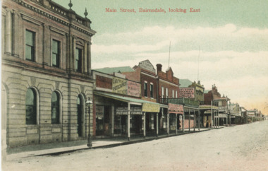 Lakes Entrance Historical Society
Postcard - Main Street Bairnsdale, 1895 c
Eastwood Brothers shown in image beside the Savings BankTinted postcard looking east of businesses on the north side of Main Street Bairnsdale Victoriatownships, businesses -
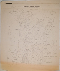 Bendigo Historical Society Inc.
Map - CAMPBELL COLLECTION: BENDIGO AND DISTRICT MAPS, 1982
Map. Forest Commission Victoria, Bendigo Forest District, Greater Bendigo Area. Shire of Marong, Sailors Gully, Epsom, Borough of Eaglehawk, Jackass Flat, White Hills, California Gully, Shire of Huntly, Maiden Gully, Long Gully, North Bendigo, Bendigo East, City of Bendigo, West Bendigo, Kennington, Shire of Strathfieldsaye, Flora Hill, Quarry Hill, Golden Square, Kangaroo Flat, Spring Gully. Prevention Strategy Plan. Base prepared 1982.map, bendigo, forest district -
 Lakes Entrance Historical Society
Album - East Gippsland Album
Twenty six images c 20 x 25 cm purchased from Apple Lea Craft Shop, W.T Dawson District Surveyor, C. W. Ligar Surveyor General of Victoria. North Arm, Jemmy.s Point, S.S Wyralla,Yacht Nyama, Kalimna Hotel, Whiters Camp Park, Metung, P.S. Tanjil, S.S. Gippsland, S.S. Burrabogie, S.S. J.C.D, White covered album containing 49 images of early East Gippsland Victoriawaterways, islands, townships -
 Bendigo Historical Society Inc.
Map - HUSTLER'S REEF NO 1 MINE - EAST & WEST CROSS-CUTS OF THE HUSTLER'S REEF NO 1 MINE
Map showing the East & West Crosscuts, North & South of Shaft of the Hustler's Reef No 1 Mine on the Hustler's Line of Reefs Bulletin No 33, Plate No XXII. Drawing shows where the different levels are, the stone encountered and smaller drawings of other sections near the shaft. Also shows some geographical features. Signed by H A Whitelaw, Underground Survey Office Bendigo, September 1913. Geological Survey of Victoria emblem.mining, parish map, hustler's reef no 1 mine, geological survey of victoria, h a whitelaw, underground survey office bendigo, hustler's line of reefs -
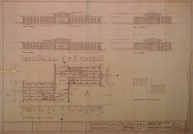 Bendigo Historical Society Inc.
Plan - SANDHURST BOYS CENTRE COLLECTION: SANDHURST TRAINING CENTRE BUILDING PLANS, 21/08/1969
Sandhurst Training Centre residential unit ground floor plan and elevations; prepared by Public Works Department for the Government of Victoria. 21/8/1969. Includes floor plan for residential units nos 1,4,5 comprising 12 bedrooms, 2 toilet blocks, living hall, crafts and tea room, laundry. The plan for units 2,3,6 is a mirror image. Also included are elevations for north, south, east and west views. Drawn Aug 1968 Senior Designing Architect John F Swan, Chief Architect D C Bradbury. .bendigo, institutions, sandhurst boys centre, sandhurst boys centre plans;, john f swan, d c bradbury -
 Wooragee Landcare Group
Photograph, 5 September 2004
... . Tatong is a rural village in north-east Victoria, set ...Wooragee Landcare Group took a bus trip Sunday 5th September to Samaria, Tatong area (near Benalla) to look at land use on small farms. Around this time, Wooragee Landcare were looking into how small land holders could run some enterprises. This photo was taken at Tatong Tavern where the group had lunch. The Tatong Tavern is an old English style pub situated in the foothills of the Great Dividing Range the small community of Tatong 23km south-east of Benalla. The original weatherboard hotel was originally built in the 1880s by William Worrall who was listed as Hotel Keeper from 1886 to 1910. It was destroyed by fire in 1923 and replaced by the current building, which has undergone many changes over the past 100 years. The name has also changed from the Tatong Hotel or ‘Pub’ to the current name of Tatong Tavern.Tatong is a rural village in north-east Victoria, set in undulating country that rises southwards to the Tolmie ranges. The name is thought to derive from an Aboriginal expression, possibly referring to something unseen. The Tatong pastoral run was taken up in 1847 and farm selections began in the 1870s. A school opened in 1890 (closed in 2006). Dairy herds were grazed on the Tatong flats and a cooperative creamery operated from 1892 until 1918. In 1914 a branch railway line was opened from Benalla to Tatong that carried farm produce and timber to Tatong, which had two sawmills in the 1920s. There was also a general store, a police station, and a livestock trucking yard. St Albans Church of England was built in 1921. Most of those buildings have now disappeared. The Tatong Tavern along with the Hall built in 1904 are the only remaining buildings. The Tatong Tavern is a significant tangible and visual representation of the area’s cultural and social history over the past 100 years. Coloured rectangular photograph printed on paperReverse: WAN NA E0NA2N2. NNN- 14240/ (No. 20) 373/ tatong, tatong pub, tatong tavern, tolmie ranges, tatong flats, benalla, wooragee landcare, wooragee landcare group, bus trip, samaria, land use, william worrall, 1800s, 2004, mount samaria -
 Lakes Entrance Historical Society
Photograph - Bullock Island Lakes Entrance, Holding M, 2000 c
photographs showing view of town from across North Arm from western boat ramp east to Orme Street continued from 04216 number 04216.1 and 04216.2 size 10 x 15 cm|. Colour photograph of town from Kalimna Heights showing Hill 60 on Hummocks taken 1975 c printed from slide number 04216.3Colour photograph of western end of town taken from Kalimna Heights showing cars parked near western boat ramp and North Arm, hummocks and Bass Strait in distance, Lakes Entrance Victorialookouts, topography, buildings, islands -
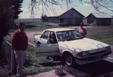 Federation University Historical Collection
Photograph - Photograph - Colour, Visiting "Launchley", c1970s
Elizabeth Chatham with her brother and sister-in-law. Taken from the back door at "Launchley", AscotElizabeth Chatham (nee Holmes) standing with family friends at “ Launchley” looking North East over the shearing shed and dairy towards Cattle Station Hill. chatham-holmes collection, holmes, elizabeth chatham, launchley -
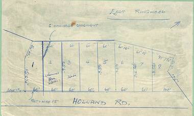 Ringwood and District Historical Society
Map - Subdivision Plans, Residential allotments in Holland Road, Ringwood East, Victoria - (Undated - circa 1950s)
Hand-drawn map on light cardboard backing - 8 numbered allotments on Holland Road (north of Everard Road - not shown). -
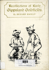 Narre Warren and District Family History Group
Book, Richard Mackay, Recollections of early Gippsland goldfields, 1977
... River Gippsland Rivers Many towns in north-east area of Victoria ...Many towns in north-east area of Victoria mentioned. Local churches, government representatives, minersnon-fictionMany towns in north-east area of Victoria mentioned. Local churches, government representatives, minersgold mining locations, omeo in 1850, stone creek on nicholson river, gippsland rivers