Showing 11139 items
matching planning
-
 Orbost & District Historical Society
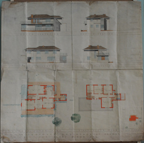
plans, July 1949
These house plans were drawn up for James Nixon. James Nixon was born in Orbost on 15.11.1912. He married Joyce May Thompson on 2.2.1937. He was a well known Orbost identity, serving a record 47 years as a Commissioner on the Snowy River improvement Trust, as well a director of Snowy River Seed and th Bean Board. He died on 21.12.2002.James Nixon, a third generation Nixon, father of Peter Nixon A.O., was an involved and respected Orbost identity. This item is a significant research tool.Architectural plans for a two-storey house with 4 bedrooms to be built on the corner of Gladstone and Tennyson Streets in Orbost. On a white background with coloured drawings ( water colour).nixon-james house-plans architecture -
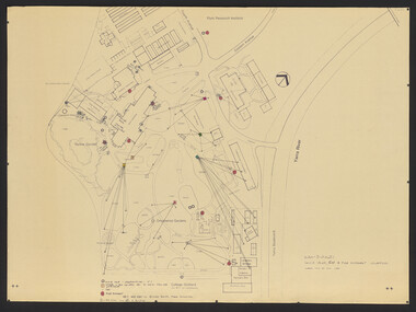
 Mission to Seafarers Victoria
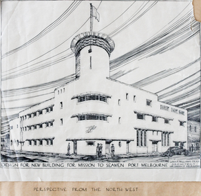
Plan - Architectural Plan, Louis Reginald Williams, Plans for the Port Melbourne Mission to Seamen by Louis R.Williams of F.R.A.I.A Architect, c. 1936
In 1936, the old Port Melbourne building dating from 1888 was too small and not longer suitable for the purpose of the mission. So architects were asked to design a new building. Harry Morris 's project was chosen.Louis Reginald Williams (1890–1980) was s sought after ecclesiastical architect in Australia. He designed churches throughout the country, particularly in Victoria. The Anglican Church was his major client but he also Methodists, Presbyterians, Lutherans and Christian Scientists churches. Williams was probably the major church architect in Australia in the Arts and Crafts tradition from the 1920s to the 1970s.Plans port melbourne, louis reginald williams, louis reginald williams (1890–1980), arts and crafts, art deco, harry norris -
 Federation University Historical Collection
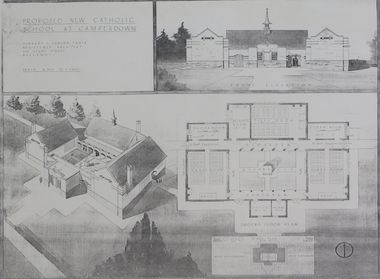
Plan (copy), 'Proposed New Catholic School at Camperdown' by Herbert L. Coburn
Ballarat born Herbert L. Coburn grew up to be a renowned Ballarat architect, practising from 1905 to 1956. He taught Architecture and Building Construction at the Ballarat School of Mines (SMB) from 1918, resigning in 1948 due to ill health. Copy of a plan for a Catholic primary school at Camperdown by H.L. Coburn. The plan includes front elevation, ground floor and block plan.coburn, h.l. coburn, herbert l. coburn, architecture, camperdown, architectural plan -
 Port Melbourne Historical & Preservation Society
Document - Specification, Pool Street from Nott Street to Princes Street, Engineering Department, Town of Port Melbourne, 14 Mar 1893
Plan for Pool Street from Nott Street to Princes Street Loan Works 1893 plan 18; relates to plan 97.2Signed by JJ Bartlett (Mayor) 14.3.1893engineering - roads streets lanes and footpaths, town planning, town clerks, mayors, arthur victor heath, james john bartlett -
Whitehorse Historical Society Inc.
Legal record - Illustration, Display Centre. Nunawading Historical Society
Architect's outing plans of museum for Schwerkolt's Cottage.Architect's outing plans of museum for Schwerkolt's Cottage. Gives concept drawings, elevations and plan. Differs in detail from final plan.Architect's outing plans of museum for Schwerkolt's Cottage. schwerkolt cottage & museum complex, architects plans -
 Bendigo Historical Society Inc.
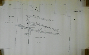
Document - MARKS COLLECTION: LANSELL'S 180 PLAN
Plan (copy) of Lansell's 180 mine shaft. Plan LH side is marked with North Old Chum Co. Shaft No. 78, in centre detailed plan of Lansell's 180 shaft, and marked on LH side of plan Victoria Quartz Co., (no detailed plan).bendigo, mining, lansell's 180 mine -
 Bendigo Historical Society Inc.
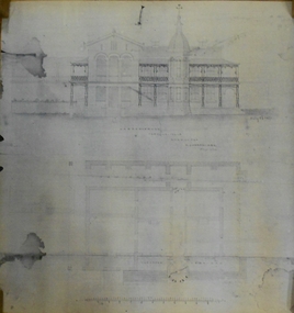
Document - MARKS COLLECTION: PLAN PRINCIPAL ENTRANCE FORTUNA VILLA AND GARDEN FRONT
2 copies of plans. 1. Smaller plan; written on plan Principal Entrance Front Fortuna Villa Sandhurst, G. Lansell Esq, Proprietor. Plan shows front entrance elevation, also floor plan of vestibule and verandah. 2. Large plan: written on plan Garden front, Fortuna Villa Sandhurst, G. Lansell, Esq. Proprietor dated July 3rd. 1871. buildings, house, fortuna villa -
 Flagstaff Hill Maritime Museum and Village
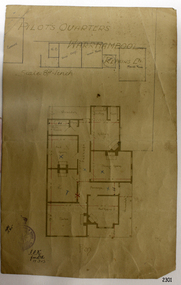
Document - Plan, Pilots Quarters Warrnambool
Warrnambool was officially made a Port of Entry in 1855 and by the 1870s had became the dominant port in the Western District. Sadly, due to an increasing problem with silting in the harbour, by the 1890s only small vessels could navigate the harbour. Men with the position of Pilot and Harbourmaster in Warrnambool were employed by the government to enforce government regulations and to help guide vessels safely into the port of Lady Bay, which was difficult to navigate. Some of the Pilots and Harbour Masters of Warrnambool were – - Captain Christopher Gwatkin, the first Harbourmaster for Warrnambool (1857 - his death in 1859). - Captain Helpman was Warrnambool’s second Harbourmaster 1859-1869 - James Nicol was Harbourmaster in Warrnambool for a time, including 1906 (b. 1840 – d. 1926) - Thomas Smith Drewett (1853 - 15-3-1905) past Captain of the Helen Nicoll, Pilot and Harbourmaster of Warrnambool. Warrnambool’s Tourist Guide of 1888 advises that “At the Port of Warrnambool there are two Leading Lighthouses. A licensed sea pilot, Captain Drewett, is stationed at the Port.” In 1915 plans for the Pilot’s Quarters were drawn up for the Department of Public Work. It was at that time, when personnel was short due to the First World War, that apparently the Pilot and Harbourmaster was also responsible for maintaining the light (lighthouse). The new Pilot and Harbourmaster’s house would be built on the site at 88 Merri Street, overlooking Lady Bay and right beside the Flagstaff and the Lady Bay Upper Lighthouse. Other Pilot and Harbourmasters were - - James Menzies was the Pilot and Harbourmaster at Warrnambool in 1929 . In 1932, he was appointed to the position of Acting Secretary to the Warrnambool Harbour Board. A hundred or so years later Flagstaff Hill Maritime Village has fully renovated the former Harbourmaster’s quarters, changed the name to Lighthouse Lodge, and is now allowing guests to stay in the home, which is still neighbour to the operational Lady Bay Lighthouses, now over 150 years old. The association of the old Pilot and Harbourmaster’s Quarters (currently renamed as Lighthouse Lodge) with the Port of Warrnambool, and its maritime activities, is historically significant. The Pilot’s quarters are connected to a time when access to Warrnambool’s Port was important to the colonial settlers for income and supplies. Plan of Pilots Quarters, Warrnambool. Printed and handwritten plan shows house, garage, out buildings and maid's room. The plan's lower left corner has an official stamp and text beside the stamp. Department of Public Works, Melbourne, Victoria, March 11th, 1915. "PILOTS QUARTERS WARRNAMBOOL" "Department of Public works, Melbourne, Victoria I.P.K. , 11.3.15"flagstaff hill, warrnambool, shipwrecked-coast, flagstaff-hill, flagstaff-hill-maritime-museum, maritime-museum, shipwreck-coast, flagstaff-hill-maritime-village, plan, pilot's quarters warrnambool, pilot and harbourmaster's quarters warrnambool, pilot and harbour master's quarters warrnambool, port of warrnambool, department of public works victoria, lady bay lighthouses, warrnambool ports and harbours -
 City of Greater Bendigo - Civic Collection
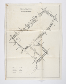
Document - Set of correspondence re Queen Elizabeth tour of Bendigo, Mrs T. R. Mannix, February 8th, 1954
Correspondence between Mrs T. R. Mannix, Swan Hill Wolf Cub Pack master to District Scout Commissioner Mr J. I. Samson for an invitation to be included with the local scout groups in functions to welcome Queen Elizabeth and the Duke of Edinburgh to Bendigo on Friday, the 5th of March 1954. The response from the Commissioner included typed plans of the event and maps of the royal tour through the streets of Bendigo starting and finishing at the train station.Set of correspondence including typed gatefold letter, typed plans for placement of visitors and role of the military and maps of CBD Bendigo and of Upper Reserve.queen elizabeth, duke of edinburgh, boy scout association, mayor clayton, city of greater bendigo royal visits, city of greater bendigo community groups, city of greater bendigo tourism -
Whitehorse Historical Society Inc.
Legal record - Land Title, Central Road, 1975
Certificate of Title Vol. 4891 Fol. 97808 to William Elliott Wilson, 2 August 1924, with transfers to 5 May 1975.Certificate of Title Vol. 4891 Fol. 97808 to William Elliott Wilson, 2 August 1924, with transfers to 5 May 1975. With floor plan of house, and letter from National Library of Australia to Mrs L Tetlow re. John Flynn's ownership of the house.Certificate of Title Vol. 4891 Fol. 97808 to William Elliott Wilson, 2 August 1924, with transfers to 5 May 1975. central road blackburn, no. 93, flynn, john, rev. -
 Federation University Historical Collection
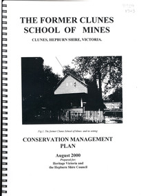
Book, The Former School of Mines Clunes Conservation Management Plan, 2000, 08/2000
The Clunes School of Mines was a campus of the Ballarat School of Mines. The conservation plan was prepared for Hepburn Shire Council and Heritage Victoria to guide the future management of the former Clunes School of Mines in Service Street, Clunes, The building was opened in February 1892 as the Clunes branch of the Ballarat School of Mines, and ceased operating in June 1893.Spiral bound black and white copy of the Conservation Plan for the Clunes School of Mines. Contents include the history, chronology development, context of the building and site, current and past function of the building, original fabric, impact of later alterations, condition of the building, statement of significance, conservation action plan, caring for the site, collecting and keeping information, structural engineers Report, Department of Lands Survey 1955, Memorandum of Agreement 1956.ballarat school of mines, clunes school of mines, australian native association, ana, australian native association clunes branch, eygelaar inner spring mattress factory, clunes infant welfare centre, clunes angling club -
 Tatura Irrigation & Wartime Camps Museum
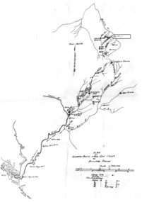
Map - Map - Photocopy, New Guinea Escape Route
At the end of January 1942 there was only about 250 men left in Wau, as the women and children had been evacuated by air a little earlier. With no planes to take the men they had to make their own way to Port Moresby and then travel by ship to Australia. Some men went down to Salamaua and made their way along the north coast, but small groups also made their way over the Owen Stanley Ranges; rafting down the Lakekamu RIver to Yule Island and by boat to Port Moresby. Donor Vanessa Kiessling's Father was part of the second group, and had drawn a detailed map of their route. This might be the same route taken by Rev. Willi Hertle (Ref C0750)Photocopy of New Guinea map showing escape routePlan of surveyed route from Edie Creek to Bulldog Dromepapua new guinea, escape, map, wau, willi hertle, kiessling -
 Kew Historical Society Inc
Map, MMBW, MMBW Plan No.39 Kew & Heidelberg, 1900-1910
The Melbourne and Metropolitan Board of Works (MMBW) was established by an act of the Victorian Parliament in 1890 to prepare for and to implement a sewerage and water reticulation system across what was then inner Melbourne, its surrounding and middle distance suburbs, including Kew. The MMBW was disbanded in 1991.The map collection of the Kew Historical Society has at its core the historic maps assembled and originally stored in the City Engineer's Department of the City of Kew. These include maps in a number of scales. The vast majority of maps were produced by the MMBW in the first two decades of the twentieth century, and are solid working maps, backed by linen for durability. These maps are historically significant to Kew, the City of Boroondara and to the history of the development of state utilities in Victoria. A number of the Kew maps have additional details added by former municipal officers, including the levels reached by various floods. As these were working documents, information was added to them long after the period of their initial production and distribution.Early map of part of the Borough of Kew, created in the first decade of the twentieth century, at a scale 160 ft to 1 inch. The map covers what was then the north western section of Kew, bordered on its north by Wills Street and the Kew Lunatic Asylum, in the west by the River Yarra [and the later added Yarra Boulevard] , by Princess Street in the East and Holroyd Street in the south. The map shows the extent of urban development by that time, prominent institutions and the outlines of built structures in the municipality. Contour lines were added in ink to the map at a later stage.MELBOURNE AND METROPOLITAN BOARD OF WORKS / PLAN NO. 39 / KEW & HEIDELBERGmelbourne & metropolitan board of works, mmbw maps, mmbw plans, borough of kew, cartography -
 Kew Historical Society Inc
Map, MMBW, MMBW Plan No.40 Collingwood & Kew, 1900-1910
The Melbourne and Metropolitan Board of Works (MMBW) was established by an act of the Victorian Parliament in 1890 to prepare for and to implement a sewerage and water reticulation system across what was then inner Melbourne, its surrounding and middle distance suburbs, including Kew. The MMBW was disbanded in 1991.The map collection of the Kew Historical Society has at its core the historic maps assembled and originally stored in the City Engineer's Department of the City of Kew. These include maps in a number of scales. The vast majority of maps were produced by the MMBW in the first two decades of the twentieth century, and are solid working maps, backed by linen for durability. These maps are historically significant to Kew, the City of Boroondara and to the history of the development of state utilities in Victoria. A number of the Kew maps have additional details added by former municipal officers, including the levels reached by various floods. As these were working documents, information was added to them long after the period of their initial production and distribution.Early map of part of the Borough of Kew, created in the first decade of the twentieth century, at a scale 160 ft to 1 inch. The map covers what was then the south western section of Kew, bordered on its north by Studley Park Road, in the west by Walmer Street and the River Yarra, by High Street South and Princess Street in the East and Barkers Road in the south. The map shows the extent of urban development by that time, prominent institutions and the outlines of built structures in the municipality. Contour lines and historic flood levels were added in ink to the map at a later stage.MELBOURNE AND METROPOLITAN BOARD OF WORKS / PLAN NO. 40 / COLLINGWOOD & KEWmelbourne & metropolitan board of works, mmbw maps, mmbw plans, borough of kew, cartography -
 Kew Historical Society Inc
Map, MMBW, MMBW Plan No.64 Kew & Heidelberg, 1900-1910
The Melbourne and Metropolitan Board of Works (MMBW) was established by an act of the Victorian Parliament in 1890 to prepare for and to implement a sewerage and water reticulation system across what was then inner Melbourne, its surrounding and middle distance suburbs, including Kew. The MMBW was disbanded in 1991.The map collection of the Kew Historical Society has at its core the historic maps assembled and originally stored in the City Engineer's Department of the City of Kew. These include maps in a number of scales. The vast majority of maps were produced by the MMBW in the first two decades of the twentieth century, and are solid working maps, backed by linen for durability. These maps are historically significant to Kew, the City of Boroondara and to the history of the development of state utilities in Victoria. A number of the Kew maps have additional details added by former municipal officers, including the levels reached by various floods. As these were working documents, information was added to them long after the period of their initial production and distribution.Early map of part of the Borough of Kew, created in the first decade of the twentieth century, at a scale 160 ft to 1 inch. The map covers what was then the northern most part of Kew, bordered on its north and west by the Yarra River, in the East by Connor's Creek and by the Asylum in the south. The map shows the extent of urban development by that time, prominent institutions and the outlines of built structures in the municipality. Contour lines and historic flood levels were added in ink to the map at a later stage.MELBOURNE AND METROPOLITAN BOARD OF WORKS / PLAN NO. 64 / KEW & HEIDELBERGmelbourne & metropolitan board of works, mmbw maps, mmbw plans, borough of kew, cartography -
 Kew Historical Society Inc
Map, MMBW, MMBW Plan No.65 Kew & Heidelberg, 1900-1910
The Melbourne and Metropolitan Board of Works (MMBW) was established by an act of the Victorian Parliament in 1890 to prepare for and to implement a sewerage and water reticulation system across what was then inner Melbourne, its surrounding and middle distance suburbs, including Kew. The MMBW was disbanded in 1991.The map collection of the Kew Historical Society has at its core the historic maps assembled and originally stored in the City Engineer's Department of the City of Kew. These include maps in a number of scales. The vast majority of maps were produced by the MMBW in the first two decades of the twentieth century, and are solid working maps, backed by linen for durability. These maps are historically significant to Kew, the City of Boroondara and to the history of the development of state utilities in Victoria. A number of the Kew maps have additional details added by former municipal officers, including the levels reached by various floods. As these were working documents, information was added to them long after the period of their initial production and distribution.Early map of part of the Borough of Kew, created in the first decade of the twentieth century, at a scale 160 ft to 1 inch. The map covers what was then the south central part of Kew, bordered on its north by Malmsbury Street, in the west by Florence Avenue, in the south by Barkers Road, and in the east by Princess Street. The map shows the extent of urban development by that time, prominent institutions and the outlines of built structures in the municipality. Contour lines were added in ink to the map at a later stage.MELBOURNE AND METROPOLITAN BOARD OF WORKS / PLAN NO. 65 / KEW & HEIDELBERGmelbourne & metropolitan board of works, mmbw maps, mmbw plans, borough of kew, cartography -
 Kew Historical Society Inc
Map, MMBW, MMBW Plan No.117 Heidelberg & Kew, 1900-1910
The Melbourne and Metropolitan Board of Works (MMBW) was established by an act of the Victorian Parliament in 1890 to prepare for and to implement a sewerage and water reticulation system across what was then inner Melbourne, its surrounding and middle distance suburbs, including Kew. The MMBW was disbanded in 1991.The map collection of the Kew Historical Society has at its core the historic maps assembled and originally stored in the City Engineer's Department of the City of Kew. These include maps in a number of scales. The vast majority of maps were produced by the MMBW in the first two decades of the twentieth century, and are solid working maps, backed by linen for durability. These maps are historically significant to Kew, the City of Boroondara and to the history of the development of state utilities in Victoria. A number of the Kew maps have additional details added by former municipal officers, including the levels reached by various floods. As these were working documents, information was added to them long after the period of their initial production and distribution.Early map of part of the Borough of Kew, created in the early twentieth century, at a scale 160 ft to 1 inch. The map covers what was then the north eastern part of Kew showing the natural landscape and limited development on the south side of the Yarra River. In the Kew section, south of the river, the land is occupied currently by the Greenacres and Kew Golf Clubs. The map shows the extent of urban development by that time and the outlines of the few built structures in the municipality. The height above sea level of all parts of the landscape are indicated numerically in feet. Contour lines and the levels of historic floods were added in ink to the map at a later stage. MELBOURNE AND METROPOLITAN BOARD OF WORKS / PLAN NO. 117 / HEIDELBERG & KEW melbourne & metropolitan board of works, mmbw maps, borough of kew, cartography, mmbw plan no. 117, kew (vic.) -- maps, heidelberg (vic.) -- maps -
![Document - Hospital Plan, Information for Preliminary Traning Students, [ca 1970]](/media/collectors/50187a8f023fd7201471f198/items/67316e6b996d5924bdd4ef10/item-media/67316edf996d5924bdd4ffc4/item-fit-380x285.jpg) Alfred Hospital Nurses League - Nursing Archive
Alfred Hospital Nurses League - Nursing ArchiveDocument - Hospital Plan, Information for Preliminary Traning Students, [ca 1970]
Alfred Hospital Medical Nursing lecture notes [ca. 1973-1976] - belonged to Susan Kim Hollands (2/73). Kim has been an AHNL member for many years, is now an archive volunteer. Her career was at the Alfred until 1980, during which time she completed nursing training, staffing and a renal-respiratory intensive care course.buff coloured manilla folder containing typed notes.non-fictionAlfred Hospital Medical Nursing lecture notes [ca. 1973-1976] - belonged to Susan Kim Hollands (2/73). Kim has been an AHNL member for many years, is now an archive volunteer. Her career was at the Alfred until 1980, during which time she completed nursing training, staffing and a renal-respiratory intensive care course. nurse lecture notes from 1970s, alfred hospital, nursing training, cardiac arrest -
Whitehorse Historical Society Inc.
Document, Blackburn Primary School Centenary, 1989, 1989
Blackburn Primary School centenary, 1889 - 1989. .Blackburn Primary School centenary, 1889 - 1989. Minutes of Centenary Committee meetings ( 2 Mar 1989 & 20 Apr 1989); order of proceedings for centenary celebrations - including sketch plan and song; tickets for Centenary Dinner Dance.Blackburn Primary School centenary, 1889 - 1989. .primary schools, blackburn primary school, no. 2923 -
 Bendigo Historical Society Inc.
Document - MARKS COLLECTION: HOBSON AND LANSELL PLANS SHOWING LAND IN DISPUTE
Plan, hand drawn, showing Hobson and Lansell plan 'shewing ground in dispute' On plan East Johnson Lease Ground, Hobson and Lansell land in between, West of England company on bottom of plan.bendigo, mining, hobson and lansell -
 Lakes Entrance Historical Society
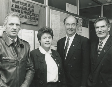
Photograph - plans for new Police Station Lakes Entrance Victoria, Lakes Post Newspaper, 1/07/1996 12:00:00 AM
announcement of plans for new Police Station L to R Inspector Alan Chaffey, Jacqueline Lalor, David Treasure MP, Bill McGrath Minister for Police and Corrective Services Lakes Entrance VictoriaBlack and white photograph at announcement of plans for new Police Station L to R Inspector Alan Chaffey, Jacqueline Lalor, David Treasure MP, Bill McGrath Minister for Police and Corrective Services Lakes Entrance Victoriapolice, community facilities, law and order -
 Federation University Historical Collection
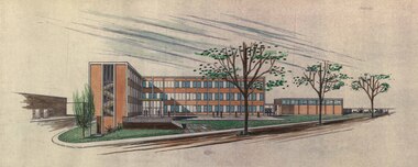
Plan, Ballarat School of Mines Building Development, 11/04/1964
With the development of tertiary education in the 1960s and 1970s the Ballarat School of Mines asked Coburn and Associates to design new buildings for the Ballarat School of Mines site, utilising the Ballarat Gaol site. The plans did not proceed, with the Mount Helen Campus being created instead. For information on Herbert L. Coburn go to http://guerin.ballarat.edu.au/curator/honour-roll/honourroll_Coburn,%20H.L.shtmlThree copies of plans by Coburn and Associates, with hand applied colour. The plans relate to a proposed development of the Ballarat School of Mines. .1) - shows the Ballarat School of Mines site, with proposed new buildings. It also shows buildings along Dana Street including the Ballarat Club, as well as White Flat. .2) View of proposed Library and Union Building .3) View of proposed Engineering Buildinguniversity of ballarat, ballarat school of mines, architect, herbert coburn, herbert l coburn, coburn and associates, architectural plans -
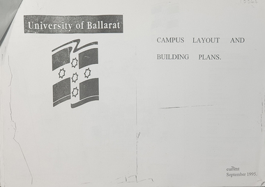 Federation University Historical Collection
Plan, University of Ballarat Campus Layout and Building Plans September 1995
University of Ballarat is a predecessor of Federation UniversityA3 pages with plans of University of Ballarat Campus layout and building plans With Compliments Slip from Prof. P. Candybuilding plans, university of ballarat, campus layout, prof. p candy, with compliments -
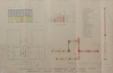 Federation University Historical Collection
Plan, Ballarat School of Mines Administration Building Proposed Office Accomodation and Strong Room Plan, 1951, 12/06/1951
Plan of Ballarat School of Mines Administration Building plan with coloured shadingballarat school of mines, administration building, new classrooms, percy e. everett -
Port Melbourne Historical & Preservation Society
Plan - Council Chambers, Borough of Sandridge, Borough of Sandridge, Mar 1861
1861 Plan for the Borough Council Chambers, Sandridge, showing "elevation" and "plan"."Frederick William Bull, Municipal Surveyor" (Sandridge March 28th, 1861)local government - borough of sandridge, built environment - civic, frederick william bull -
University of Melbourne, Burnley Campus Archives
Document, Garden Week, 1986-1991
Notes for planning Garden Week, attendance figures, site plan, etc.garden week, attendance -
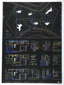 RMIT Design Archives
Architectural drawings, Plans and details for the Group Housing Project, Ivanhoe
Includes site plan; floor plans and details of utilities, interior and fittings.architecture, domestic architecture -
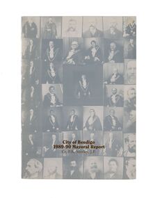 City of Greater Bendigo - Civic Collection
Financial record - Mayoral Report, City of Bendigo, 1990
Financial and civic report.A4 size Mayoral report including Councillor and Executive officer information, organisational structure, economic development, planning, family and leisure services. No mention of arts or cultural services. non-fictionFinancial and civic report.mayor morley, mayoress morley, councillor p. r. morley -
 University of Melbourne, Burnley Campus Archives
Plan, VCAH -Burnley: Sluice Valve, Tap & Fire Hydrant Locations, c. 1987
Plan showing locations and instructions for use, hand drawn. "Overlay onto SP1 Plan 1/1987," handwritten on it. Plan same as 11.0715.vcah, sluice valves, taps, fire hydrants -
 Kew Historical Society Inc
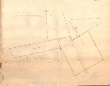
Plan - Subdivision Plan, J Hurrey, Section 115 in the Parish of Boroondara Near Richmond Bridge, 1853
Despite the plans claims that it is a subdivision near the Richmond Bridge, Section 115 was located at what is now Camberwell Junction. While the plan only lists government roads rather than named streets, the section was located on the east side of Burke Road, stretching up the hill from the current Junction. Research on Trove, conducted by Kerry Fairbank, discovered an advertisement for unsold lots in Section 115 which clarifies the extent and location of subsequent land sales in the original section. The original article can be viewed through the link in the catalogue record. The interesting link to Kew is the reference to James Beavan as the purchaser of lots 14 and 15. The historian Gwen McWilliam has notes that a Mr Beavan changed his name from Bevan. The Bevans were descendants of the Derricks family of Kew. This subdivision plan is the earliest original map or plan in the collection which shows parts of what is now the City of Boroondara, dating from circa 1853. It provides important information for researchers on subsequent subdivisions following the original land sales in [Camberwell] Boroondara. The site, on the east side of Burke Road is a highly-significant and historic site. This is believed to be the only extant copy of the subdivision in public collections.A small plan on parchment listing 28 lots, between one and two acres each, for sale in Section 115 in the Parish of Boroondara, dating from 1853 when the portion was subdivided.Obverse: Lot 16 "Joseph Duval", Lots 14 & 15 "James Beavan". Other annotations (measurements) are unreadable. Reverse: "KH-981 / Section 115 in the Parish of Boroondara / Near Richmond Bridge / 1640T. / J Duval / 14-15 J. Beavanparish of boroondara, subdivision plans - camberwell, section 115 - boroondara, subdivision plans -- camberwell (vic), riverscape road, burke road, camberwell junction