Showing 2288 items matching " parish."
-
 Bendigo Historical Society Inc.
Map - SERPENTINE, No date Visible
Map: Township of Janiember (name crossed out and 'Serpentine' hand written in its place, Parish of Janiember east, County of Bendigo ( number 156 in Map Cupboard 1)map, bendigo, township, serpentine, janiember, parish of janiember east, county of bendigo -
 Uniting Church Archives - Synod of Victoria
Photograph, Undated
B&W photograph of Helen Cardell in her garden spreading contents of the 10,000th bag of fertilser sold to Melbourne parishes by the Camperdown Men's Fellowship with proceeds to the Share Appeal.cardell, bob, cardell, helen, share appeal -
 Whitehorse Historical Society Inc.
Document, Mitcham, 1/03/1915
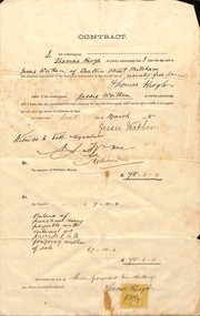
Contract of sale of part Crown Portion 119,05 Mitcham, Parish of Nunawading, County of Bourke being Lot 6 on plan of subdivision No. 5339, by Thomas Keogh to Jessie Wathenland sales, wathen, jessie, keogh, thomas, mitcham -
 Whitehorse Historical Society Inc.
Legal record - Correspondence, Land valuation, 28/04/1988 12:00:00 AM
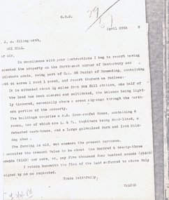
Valuation of land, North East corner of Canterbury and Middleborough Roads, part of C.A. Parish of Nunawading,Valuation of land, North East corner of Canterbury and Middleborough Roads, part of C.A. Parish of Nunawading, 44 acres, weatherboard house on property and outbuildings. Value 5,400 pounds.Valuation of land, North East corner of Canterbury and Middleborough Roads, part of C.A. Parish of Nunawading, land values, ellingworth, john roger, middleborough road, blackburn, canterbury road -
Whitehorse Historical Society Inc.
Pamphlet, Miss Geraldine Hornby, 2/08/1992 12:00:00 AM
Parish News publication for St John the Evangelist, Mitcham.Parish News publication for St John the Evangelist, Mitcham with an article on Miss Geraldine Hornby who ran St John's school single handed from 1900 to 1932.Parish News publication for St John the Evangelist, Mitcham. hornby, geraldine, st johns catholic church, mitcham, st johns catholic school, mitcham -
 Whitehorse Historical Society Inc.
Document - Extract of Land Conveyance, Patrick Riley, 9/5/1870
Photocopy of extract of Memorial Book of conveyance dated 9/5/1870 for sale of land in the Parish of Nunawading. Sold by James Coyne Riley to Patrick Riley. 3 pages.land sales;, riley, patrick, james coyne -
Southern Sherbrooke Historical Society Inc.
Map - photocopy
A photocopy taken from the original land sale map provided to the society through Karel Coxell of Stockdale & Leggo. The original maps are stored in large bound account books and were originally the propert of McNally Real Estate. The books are held (in 2A3 photocopy of plan of survey of part of Crown Allotments 20 & 21, section C, parish of Narre Worran, County of Mornington. Clements Ave and environs in Belgrave Heights"Villette Estate" in top LH corner, "Locality Plan" in bottom LH corner, "Not in sale" written on one block and crossed out. All handwritten in pencil on original. "Colby Drive " and "Verona Street" added in pencil to copy.land sales, advertisements, subdivision -
 Bendigo Historical Society Inc.
Document - RANDALL COLLECTION: BEAMENT FAMILY HOME SITE, 10 Jan 1877
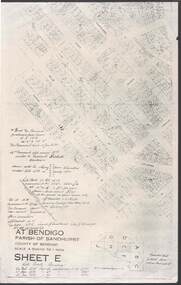
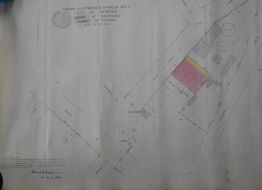
Document, Beament Family Home Site, Allotment 11C, Section 117C, 40 Garsed Street, Bendigo.This was obtained from Parish of Sandhurst, City of Bendigo, Sheet E.bendigo, house, beament family -
 Bendigo Historical Society Inc.
Map - BENDIGO WEEROONA GASWORKS MAP/PLAN COLLECTION: CROWN ALLOTMENTS 13/14, 1942
Map: crown allotments 13 and 14, Sec. E. City of Bendigo, Parish of Sandhurst. Shows site of Bendigo Gasworks. Prepared by Garnel Gordon Birch Surveyor, 12.6.1942map, bendigo, gasworks, gas company, plans -
 Bendigo Historical Society Inc.
Map - BENDIGO (PART), No date visible
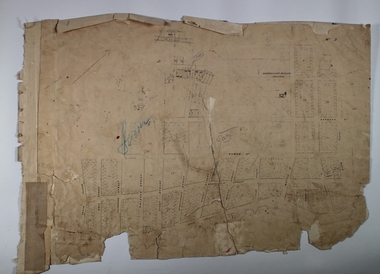
Map:Part of Sandhurst City streets, showing west side of High St. between Ophir St. and View Place. Parish plan. Older unidentifiable map on the reverse side.map, bendigo, city streets, bendigo city streets, sandhurst city streets -
Stawell Historical Society Inc
Map, Township of Stawell
B/W map of Stawell Surveyed by Easton Johnston Contract surveyor Scale in Chains. Showing Special Allotments Reefs, Pleasant Creek Parish of Stawell. Map No L4000 -
 Orbost & District Historical Society
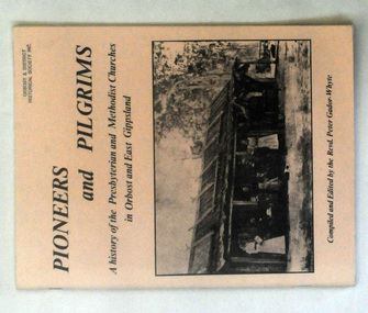
books, Pioneers and Pilgrims, 1986
Rev Peter Gador-Whyte's first UCA Parish was at Orbost in East Gippsland.This is a local history book useful for research and written by a local.Two copies of a 76 pp book titled Pioneers and Pilgrims a history of the Presbyterian and Methodist Churches in Orbost and East Gippsland. The front cover is buff coloured and has a b/w photograph of a group of people standing outside a hut with a bark roof. On the right hand side is a man on a horse. The book was compiled and edited by the Revd Peter Gador-Whyte.2178.2 - Ruth Leggechurch-history presbyterian-methodist-orbost -
 Greensborough Historical Society
Map, Victoria. Department of Crown Lands and Survey, Keelbundoora; Counties of Bourke and Evelyn, 1950c
Map of the Victorian counties of Bourke and Evelyn showing parish boundaries and land ownership.Show the original landholders for this area.Map on light brown parchment, covered in plastic."L.5305" and "3462" -
 Ballarat Diocesan Historical Commission
Magazine, Bungaree YCW Magazine, 1953
Rev. Dr Delaney advocated for the formation of the Ballarat CYMS. Curtin and Scullin being members and learning their debating skills there. The Diocese of Ballarat advocated the development of the Young Christian Workers', YCW, over the CYMS from the 1940's onward as there was a stronger spiritual development base. While there are earlier examples, this is one example of a parish based youth magazine from the organisation in the diocese of Ballarat. Prominent in this YCW group was former Victorian politician Frank Sheehan and local Shire President John Parkin. Bungaree parish had very active parish youth organisations with published journals dating back to the 1930s. Initiallyl producing CYMS magazines at a parish level this had transferred to the YCW by the 1950s and this was the first YCW issue.The Ballarat Catholic Young Men's Society, CYMS was established in1892 and catered for Catholic youth. ycw, bungaree parish, youth group, curtin, scullin, sheehan, parkin. -
 Greensborough Historical Society
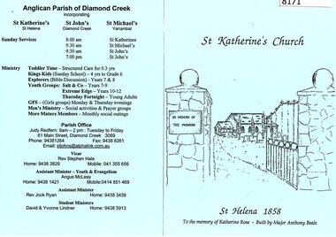
Pamphlet - Leaflet, St Katherine's Anglican Church St Helena 1858, 1990s
Contains a history of St Katherine's Church St Helena, Major Anthony Beale and his wife Katherine Rose after whom the church and chapel are named. Includes current parish information and contacts. [Rev Stephen Hale become vicar of St John's parish in Diamond Creek in the 1990s]Background to this well known pioneer church.One A4 page, folded in 2. Printed on blue coloured paper.st katherines church, st helena, anthony beale, rose chapel -
 Greensborough Historical Society
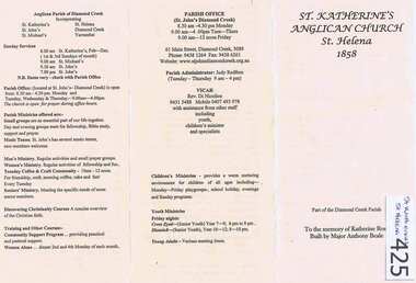
Leaflet, St Katherine's Anglican Church St Helena 1858, 1858o
Contains a history of St Katherine's Church St Helena, Major Anthony Beale and his wife Katherine Rose after whom the church and chapel are named. Includes current parish information and contacts. [Rev Di Nicolios become rector of St John's parish in Diamond Creek in 2002]Background to this well known pioneer church.One A4 page, folded in 3. Printed on buff coloured paper.st katherines church, st helena, anthony beale, rose chapel -
 Linton and District Historical Society Inc
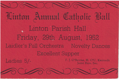
Card - Ticket, Linton Annual Catholic Ball, 1952
Red ticket, black printing. Ticket is for Linton Annual Catholic Ball, held 29th August 1952. Ticket price five shillings. "Laidler's full orchestra, novelty dances, excellent supper".Text: ' Linton Annual Catholic Ball / Linton Parish Hall / Friday, 29th August, 1952 / Lidler's Full Orchestra Novelty Dances ' Excellent Supper. 'linton parish hall, linton annual catholic ball, social gatherings, balls -
 Ringwood and District Historical Society
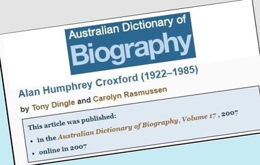
Document - Biography, Alan Humphrey Croxford (1922-1985)
Copy of article by Tony Dingle and Carolyn Rasmussen published in Australian Dictionary of Biography, Volume 17, 2007 (2 pages), and copy of Certificate of Title Vol 4197 Fol 839286, 1919 (3 pages).Ringwood connection - Property Title transfer history 1969 and 1973, part of Crown Section 20, Parish of Warrandyte, County of Evelyn, Bemboka Road, Warranwood. -
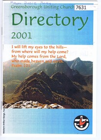 Greensborough Historical Society
Booklet, Greensborough Uniting Church, Greensborough Uniting Church Directory 2001, 2001
Parish directory for the Greensborough Uniting Church, 2001: staff and congregation listing and contact details12 p. black and white print , cover in colourgreensborough uniting church -
Whitehorse Historical Society Inc.
Map, Melbourne and Metropolitan Board of Works, Feb 1982
Map area: North - Laburnum and Blackburn Stations East - Blackburn Lake South - bordering Canterbury Road West - Middleborough Roadnon-fictionMap area: North - Laburnum and Blackburn Stations East - Blackburn Lake South - bordering Canterbury Road West - Middleborough Roadmaps, melbourne and metropolitan board of works, parish of nunawading -
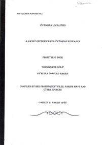 Bendigo Historical Society Inc.
Book - STRAUCH COLLECTION - VICTORIAN LOCALITIES, A HANDY REFERENCE FOR VICTORIAN RESEARCH, FROM THE BOOK 'DIGGING FOR GOLD' BY HELEN DOXFORD HARRIS, 1988
Victorian Localities, a handy reference for Victorian research, from the book 'Digging for Gold' by Helen Doxford Harris, compiled by her from inquest files, parish maps and other sources.Helen D Harrisvictoria, history, localities -
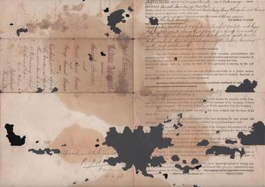 Bendigo Historical Society Inc.
Document - HARRIS COLLECTION: TRIBUTORS 'AGREEMENT' DOCUMENT (HARRIS), 17th February, 1896
Stained and holed Tribute 'Agreement' document (Harriet Harris - the 'Company' and David Henry Harris and George Samuel Harris, the 'Tributors' dated Feb 17th 1896) remaining in Parish of Axedale.person, individual, harris -
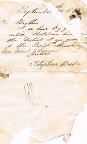 Bendigo Historical Society Inc.
Document - ANCIENT ORDER OF FORESTERS NO. 3770 COLLECTION: CORRESPONDENCE
Note from Stephen Barton, dated September 15 1873, mentioning that he was leaving the District. He went to the Parish of Muskery, near Mount Pleasant. Signed by Stephen Barton.societies, aof, correspondence, ancient order of foresters no. 3770 collection - correspondence, stephen barton -
Bendigo Historical Society Inc.
Map - BENDIGO (PART), No date visible
Map: Portion of Bendigo parish plan, showing from Murphy St. East to Bob St and between rail line to old saleyards to the old Heathcote line Canvas backed.map, bendigo, city streets, bendig parish plan , bendigo city streets -
Whitehorse Historical Society Inc.
Map, Dandenong Ranges Area, 1955
Sheet 13. Parts of Parishes: Nunawading, Mulgrave and Scoresby.Sheet 13. Parts of Parishes: Nunawading, Mulgrave and Scoresby. Includes area of Vermont South marked as proposed Township of Norwich. Scale 10 chains : 1 inch. Contours marked.Sheet 13. Parts of Parishes: Nunawading, Mulgrave and Scoresby. maps, vermont south, wantirna, dandenong creek -
Whitehorse Historical Society Inc.
Legal record - Document, Certificate of Title, 1927
Certificate of Title vol. 5411, fol. 1082004, 23 December 1927, pt. Crown Portion 108, Parish of Nunawading, Middleborough Road, owned by Albert Edwin Victor CavillCertificate of Title vol. 5411, fol. 1082004, 23 December 1927, pt. Crown Portion 108, Parish of Nunawading, Middleborough Road, owned by Albert Edwin Victor CavillCertificate of Title vol. 5411, fol. 1082004, 23 December 1927, pt. Crown Portion 108, Parish of Nunawading, Middleborough Road, owned by Albert Edwin Victor Cavillshire of blackburn and mitcham, middleborough road, burwood east -
Whitehorse Historical Society Inc.
Legal record - Land Title, Certificate of Title, 23/12/1927 12:00:00 AM
3 Acres 2 roods 8 and 7/10th perches, pt. Crown section 108 Parish of Nunawading, owned by Thomas Gifford Anderson. Vol. 5411 fol. 10820053 Acres 2 roods 8 and 7/10th perches, pt. Crown section 108 Parish of Nunawading, owned by Thomas Gifford Anderson. Vol. 5411 fol. 10820053 Acres 2 roods 8 and 7/10th perches, pt. Crown section 108 Parish of Nunawading, owned by Thomas Gifford Anderson. Vol. 5411 fol. 1082005anderson, thomas gifford, middleborough road burwood east, highbury road burwood east -
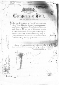 Whitehorse Historical Society Inc.
Certificate - Land Title document, Crown Allotment, 5/11/1909
Certificate of Title dated 5/11/1909 covering land in Shady Grove Nunawading purchased by Mary Higgins. Crown Land Allotment No. 116 Parish of Nunawading County of Bourke.land titles, higgins, mary, holmes, dave, shady grove nunawading no.76, helen -
Whitehorse Historical Society Inc.
Document, Extract from Parliamentary debates, 2006
Statements by Hon. H.E. Buckingham (Koonung) after a church service combining parishes of Christ Church Mitcham and All Saints Mitcham.Statements by Hon. H.E. Buckingham (Koonung) after a church service combining parishes of Christ Church Mitcham and All Saints Mitcham. and a copy of her final speech in the Parliament of VictoriaStatements by Hon. H.E. Buckingham (Koonung) after a church service combining parishes of Christ Church Mitcham and All Saints Mitcham.all saints anglican church mitcham, christ church anglican church mitcham, buckingham, helen, victoria. parliament. legislative assembly -
Whitehorse Historical Society Inc.
Map, Nunawading, Ringwood and Scoresby, 16/02/1858 (original)
Plan of country lands in the Parishes of Nunawading, Ringwood and Scoresby in the Counties of Bourke and Mornington. Lithographed at the Public Lands Office, Melbourne, 16 February 1858. Inset: Pound Reserve, Nunawading.nunawading, ringwood, scoresby, maps