Showing 10971 items matching " plan"
-
 Federation University Historical Collection
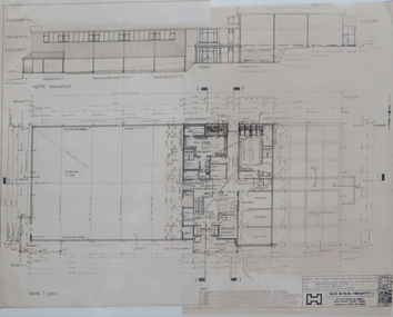
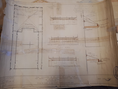
Plan, R.L.F.J. Hillman Recreation Building
Photocopy plansn for proposed recreation building, Grant St mr hillman, g. hewitt, hillman recreation building, school of mines ballarat -
 Federation University Historical Collection
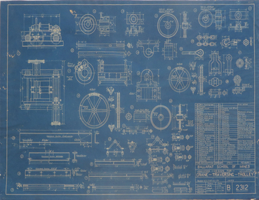
Blueprint Plan, Crane Transversing Trolley, 1934-5
Blueprint plan of a crane-transversing-trolley v. hunt, plan, chambers, crane tranversing pulley -
 Port Melbourne Historical & Preservation Society
Plan - Proposed Bayside development, Sep 1987
SCDC plans for the Bayside development were revised as investigations into water circulation in artifical canals/harbour were completed. This is the altered plan, with alterations drawn in red on the original proposal, for the EES hearing in September 1987. The EES hearing, scheduled for three days in September, ran for 57 sessions into February 1988.Large plan of original proposed Bayside development as submitted to council in 1987; as 502.01 but with alterations superimposed in red, It was this altered plan that was submitted at the enquiry into the Environmental Effects Statement in September.In blue: EES Variation September 1987:In red: markings to indicate alterations to land configurationtown planning - proposals shelved - bayside, sandridge city development co pty ltd, scdc -
 Greensborough Historical Society
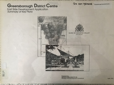
Plan - Application, Wilson Sayer Core Pty Ltd, Greensborough District Centre: East side development application: summary of key plans. 1992, 1992_04
A summary of the plans for the Greensborough District Centre from 1992, with plans for the development of the East side of Main Street Greensborough.16 pages. Black and white line drawings and plans. Has plastic cover and wire binding. greensborough district centre, main street greensborough -
 Orbost & District Historical Society
folder of documents, 1992-1993
Orbost Aero Club began in 1969 with Basil Dowie as Chair, David Nixon as Secretary/Treasurer. The group went into recess from 1977-1991 closing in 1997. The mid 1960s were boom years in flying training in Australia and the number of Aero Clubs grew rapidly. The Club played a significant role in the establishment of the small airport at Marlo and in the ongoing operation and development of the airport over the years particularly for patient transfer by aerial ambulance. The Orbost Aero Club Club played a significant role in the establishment of the small airport at Marlo and in the ongoing operation and development of the airport over the years.A manila folder containing plans and approvals for the airport terminal building at Marlo Airport. On a label on front - AIRPORT TERMINAL BUILDING 1992/1993 plans & approval ORBOST AERO CLUBorbost-aero- club marlo-airport -
 Vision Australia
Plan - Image, Conversion to Administrative offices / Conversion to Rehabilitation centre, 1 November 1962 - 5 April 1963
Over 1962-63, plans were drawn up for the conversion of the main building into administrative offices and a rehabilitation centre. As the children were now located at the school in Burwood, and with funds achieved from the sale of the old factory buildings to the Alfred Hospital, the St Kilda Road building could expand room for its office workers and provide greater floor space to rehabilitation staff. These plans show the proposed conversion from bedrooms to administrative and rehabilitation areas.7 architectural plans and 1 letterJohn F D Scarborough and Partners, Architectsroyal victorian institute for the blind, plans -
 Vision Australia
Plan - Image, New verandah & draining to court for the Royal Victorian Institute for Blind, April 1924
In 1924 plans were submitted to the RVIB board for the addition of a new veranda and associated drainage pipes located in the courtyard behind Ormond Hall. Hand written notes on the plan indicate that the tender for materials from Pollards was 330 pounds, asphalt 35 pounds totally a cost of 365 pounds. And that additional costs of 120 pounds, comprising of 20 for G Lavatory (?) and J Famdy (?) 100 pounds.1 architectural plans for proposed verandah and drainageStephenson & Meldrum, Architects Collins Court 374 Little Collins Street Melbourne Phone: 6990royal victorian institute for the blind, plans -
 Federation University Historical Collection
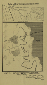
Plan, Lal Lal Iron Ore Deposits, Moorabool River, 1881
This plan was printed in the Ballarat School of Mines Annual Report were Ferdinand Krause was a professor.Printed plan showing iron ore deposits at Lal Lal.lal lal ore, moorabool river, ferdinand krause -
 Mission to Seafarers Victoria
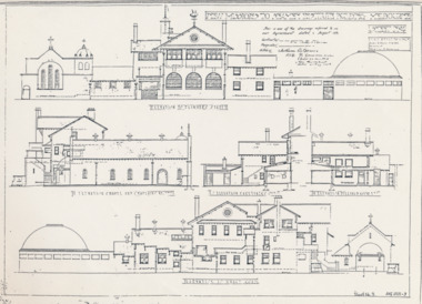
Plan - Architectural drawings, Walter Butler, New Missions to Seamen Institute Buildings Melbourne, 1916
In August 1916, Walter R. Butler presented the plans for the future central Seamen's Institute.The drawings show the original plans with rooms' names and intended use. They also show the original concept for the chapel which was in the Spanish Mission style.Plan copied from the 1983 Howden and Wardrop A4 report. flinders street, mission to seamen, mission to seafarers, walter richmond butler (1864–1949), norla dome, st peter chapel, spanish mission, arts and crafts, 1916 -
 Mission to Seafarers Victoria
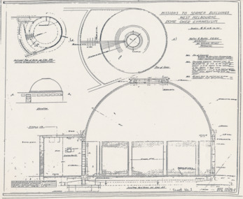
Plan - Architectural drawings, Walter Butler, Missions to Seamen Buildings, West Melbourne, Dome Over Gymnasium, 1916
In August 1916, Walter R. Butler presented the plans for the future central Seamen's Institute.The drawings show the original plans with rooms' names and intended use. They also show the original concept for the chapel which was in the Spanish Mission style.Plan copied from the 1983 Howden and Wardrop A4 report. flinders street, mission to seamen, mission to seafarers, walter richmond butler (1864–1949), norla dome, st peter chapel, spanish mission, arts and crafts, 1916 -
 Bacchus Marsh & District Historical Society
Map, Limestone Reserve Parish of Merrimu 1888
Limestone deposits in the Coimadai area 10 kilometers north of Ballarat were first worked in the 1850s. The area was quarried for limestone for many years by various people and companies. The surveyor's name who produced this plan is inscribed on the map and below this is the name P. L. Alkemade, who presumably paid for the map to be produced. In 1886 Petrus Alkemade in partnership with Matthew Egan established the Alkemade Hydraulic Lime and Cement Company. The Alkemade family were involved in the limestone industry over several generations at Coimadai.Single page map showing part of the Limestone reserve near Coimadai in the Parish of Merrimu. Scale 4 chains to 1 inch. Part of a set of maps which are pasted into a bound volume containing 76 maps or plans in total. High resolution digital image stored on BMDHS computer network. Copy of plan surveyed by Mr. G? [illegible] an authorised surveyor on 17th July 1888. P. L. Alkemadebacchus marsh victoria maps, lime kilns coimadai, limestone, coimadai victoria maps, alkemade family coimadai -
 Ringwood and District Historical Society
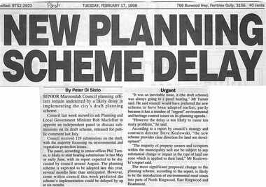
Newspaper, Scrapbook Clipping, Library Collection, Ringwood, Victoria, `
``Newspaper clipping from the "Post", Tuesday February 17, 1998. NEW PLANNING SCHEME DELAY. By Peter Di SistoSenior Maroondah Council planning officers remain undeterred.by a likely delay in implementing the city's draft planning scheme. Council last week moved to ask Planning and Local Government Minister Rob Maclellan to appoint an independent panel to discuss submissions on its draft scheme, released for public comment last July. ` -
Clunes Museum
Plan - PLAN/MAP, SOUTH CLUNES GOLD MINE
PLAN AND MAP OF SOUTH CLUNES GOLDMINEPLAN OF SOUTH CLUNES UNITED G.M.CO.CLUNES PRODUCED OR DRAWN BY F.W.NIVEN & CO LITH BALLARATlocal history, document, mining, plans -
Federation University Historical Collection
Plans, Plans of the Wimmera College of TAFE, 1983, 18/05/1983
The plans were prepared by the Public Works Department VictoriaBook of plans relating to the Wimmera College of TAFE. The book includes developed sketch plans, site plans and landscape plans for the Horsham Technical School site and Langerenong Agricultural Collegewimmera, horsham, wimmera college of tafe, horsham technical school, longerenong, longerenong agricultural college, p. martin, j.t. green -
 Kew Historical Society Inc
Plan - Subdivision Plan, Houghton Street & Buchanan Avenue, Balwyn North, ca. 1906
The Kew Historical Society collection includes almost 100 subdivision plans pertaining to suburbs of the City of Melbourne. Most of these are of Kew, Kew East or Studley Park, although a smaller number are plans of Camberwell, Deepdene, Balwyn and Hawthorn. It is believed that the majority of the plans were gifted to the Society by persons connected with the real estate firm - J. R. Mathers and McMillan, 136 Cotham Road, Kew. The Plans in the collection are rarely in pristine form, being working plans on which the agent would write notes and record lots sold and the prices of these. The subdivision plans are historically significant examples of the growth of urban Melbourne from the beginning of the 20th Century up until the 1980s. A number of the plans are double-sided and often include a photograph on the reverse. A number of the latter are by noted photographers such as J.E. Barnes.A hand-drawn subdivision plan listing six blocks bounded by Houghton Street, Doncaster Road, Buchanan Avenue and Maud Street, North Balwyn. Written on the plan of subdivision are the lot numbers, the dimensions of the blocks and the price at which two lots were for sale or had been sold for.subdivision plans - balwyn -
Stawell Historical Society Inc
Map, Shire of Stawell, Shire of Stawell Interim development Order, C 1930
Planning MapColoured Map of Stawell Shire showing Zoning AreasGuttering Haskings & Davey Pty Ltd Division of Urban and Environmental Planninglocal development -
 Bendigo Historical Society Inc.
Map - BENDIGO WEEROONA GASWORKS MAP/PLAN COLLECTION: LAY OUT OF NORTHERN SECTION, 1982
Plan of Bendigo Weeroona Works, works lay out northern section. Written on bottom of plan: this tracing from old drawing …. (?) difficult to read, very faded.plan, bendigo, bendigo weeroona gasworks, gas works -
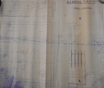 Bendigo Historical Society Inc.
Map - BENDIGO WEEROONA GASWORKS MAP/PLAN COLLECTION: DETAILS FOUR PURIFIERS, 1889
Plan/map: Bendigo Weeroona Gaswork, plan showing details four purifiers. Plan signed by? Thompson engineer, dated 1889. Written on bottom RH: this is one of the drawings referred to in my contract dated ... (undated).plan, bendigo, bendigo weeroona gas works, gasworks, thompson -
University of Melbourne, Burnley Campus Archives
Work on paper, Garden Style and the Australian Landscape, September 2002
student work, assignment, plan, axonometric drawing -
University of Melbourne, Burnley Campus Archives
Plan (Item), Repairs etc. to Caretaker's Cottage, Horticultural Gardens, Burnley Melb, 1933
Appears to be the cottage at the western end of the site, near the level crossing, occupied by the stockman (George Hudson ,followed by Tom Kennedy, then George Manley) Plan signed by J.B. McLean, District Architect, 24.1.33caretaker's cottage, burnley gardens, stockman's cottage, george hudson, tom kennedy, george manley, j.b. mclean -
Port Melbourne Historical & Preservation Society
Plan - Cottage, c. 1865
IF Toll Gate Plan, refer Minute Book (Reg 234) September 1865 IF Poundkeeper's Cottage, see 7 December, 1865 referring to preparation of plan for house for Poundkeeper, (guesswork!)Front, side and section elevations and floor plan for unidentified cottage and gate, 1860s. Possibly tip tender.built environment - domestic -
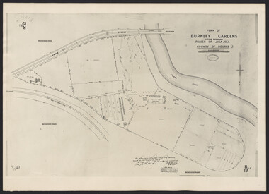 University of Melbourne, Burnley Campus Archives
Photograph - Plan of Burnley Gardens
"This plan is a copy of a copy of the survey made by Mr. Turner in 1926. The original plan and field notes are missing _ file Rs 3529" Signed by _signature unreadable_ -
Glenelg Shire Council Cultural Collection
Photograph - Photograph - Portland Harbour Development, n.d
Port of Portland Authority ArchivesFront: Black & white Photograph of a plan showing proposed changes to the Fisherman's Breakwater area of the Port of Portlandport of portland archives, port of portland -
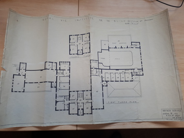 Vision Australia
Plan - Image, Royal Vic Institute for the Blind Hirings Service, 18/12/1943
Plan of the first and second floors of the main building at 557 St Kilda Road, created by the RAAF during it's occupation of the same between 1942-1944.1 architectural plan of St Kilda Road main buildingroyal victorian institute for the blind, plans, raaf -
Clunes Museum
Document - STRATEGIC PLAN, STRAGETIC ENTERPRISE DEVELOPMENT PTY. LTD
DOCUMENT: STRAGETIC PLAN - CLUNES TOURISM AND BUSINESS DEVELOPMENT PROJECT. CLUNES TOURIST AND DEVELOPMENT ASSOCIATIONstragetic plan, document, plan -
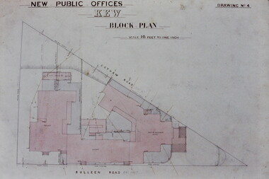 Kew Historical Society Inc
Slide - Architectural Drawing, Kew Public Offices, 1887
A civic campaign for new public offices developed in Kew in the 1880s. After much deliberation, the location chosen was the junction of Bulleen and Cotham Roads. The buildings were designed by George Watson and John Henry Harvey, architects within the Department of Public Works (Victoria). Building was commenced in 1887, and after one year, the buildings were opened. The Post Office was transferred to the new Commonwealth Government in 1901. The Police Station and Court House, sold by the Victorian Government to the City of Boroondara in 2007, are now a community cultural centre and performing arts venue.The buildings were listed on the Victorian Heritage Register Register (HO885) in 1991. They are historically and architecturally significant to the State Of Victoria because Watson and Harvey's designs exhibit diversity in integrating civil offices, they accommodate the apex of road junctions, and they demonstrate a departure from the contemporaneously favoured High Victorian Classical to the Queen Anne style in the design of civic buildings. 35mm colour transparency of an original plan by George Watson and John Henry Harvey, architects of the Department of Public Works (Victoria), in 1887 for New Public Offices at Kew. This plan was copied by the donor from an original held at the Commonwealth Archives in Brighton (Vic). The copy was made to illustrate a report that the donor made on ‘The functional planning design, building materials and construction methods of the Kew Post Office’ as part of course work at RMIT.NEW PUBLIC OFFICES KEW / BLOCK PLAN / SCALE 16 FEET TO ONE INCH / DRAWING NO 4kew court house, kew police station, kew post office, architectural drawings, khs - slides, new public offices — kew (vic.), architecture — queen anne style -
Tatura Irrigation & Wartime Camps Museum
Plan - Diagram/Plan, Lathe
Plan of a wood turning lathe made by internee at camp 3. diagram and description of each piece in the plan to make a wood turning lathe. Has been laminated.lathe plans, lathe diagram, rudy hoefer, woodworking equipment -
University of Melbourne, Burnley Campus Archives
Plan - Teaching Material, Laidlaw & Laidlaw, Patterson Park Metung Draft Conception, January 2013
teaching material, plan, landscape design, laidlaw & laidlaw design, east gippsland shire, metung, patterson park -
 Bendigo Historical Society Inc.
Map - BENDIGO WEEROONA GASWORKS MAP/PLAN COLLECTION: COMPRESSOR PLAN LAYOUT, 15.2.1971
Plan showing compressor plan layout at Bendigo Weeroona Gasworks. Prepared by Gas and Fuel Corporation Development Department.plan, bendigo, bendigo weeroona gas works, gasworks, public utility, gas and fuel corporation