Showing 18852 items
matching town
-
 Kew Historical Society Inc
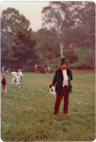
Photograph - Historic re-enactment during the Festival of Kew, 1978
At the 1978 Festival of Kew, a number of organisations, including the City of Kew, the Kew Historical Society, Trinity Boys Grammar School and local Girl Guides participated in a re-enactment of the expedition of the party of Charles Grimes in surveying the Yarra River as far as Kew in February 1803. The location for the event was Yarra Bend Park near the Studley Park Boat House. The event was organised by the Kew Historical Society. The re-enactment was captured by a number of amateur photographers as well as by a photographer from the local Progress Press.Local communities select events to commemorate according to their shared history and values. Commemorations of colonial exploration were popular with local historical groups such as the Kew Historical Society in the twentieth century. In re-enacting events such as the Grimes survey of the Yarra, students from a local school were encouraged to take on specific roles, including play-acting individuals involved in the survey party as well as members of the local Wurundjeri People. The photographs, taken by amateur and professional photographers, represent a period in time when the dominant values were those shared by the descendants of European settlers in Victoria. Original colour photographic positive of Cr Allan Hutchinson, dressed as a town crier in the re-enactment.Annotated on reverse: "CR HUTCHINSON 1978 / TOWN CRYER"kew historical society, trinity grammar school, kew girl guides, city of kew, yarra river, charles grimes, collins expedition, wurundjeri people, yarra bend park, colonial surveys, historic re-enactments, festival of kew, kew festival, cr allan hutchinson -
 The Beechworth Burke Museum Research Collection
Card (Series) - Index Card, George Tibbits, Cnr William and Last Streets, Beechworth, 1976
George Tibbits, University of Melbourne. Faculty of Architecture, Building and Town & Regional PlanningIndex system that support the research for Beechworth : historical reconstruction / [by] George Tibbits ... [et al]Arranged by street names of BeechworthEach index card includes: street name and number of property, image of property, allotment and section number, property owners and dates of ownership, description of the property according to rate records, property floor plan with dimensions.beechworth, george tibbitsbeechworth, george tibbits -
 Eltham District Historical Society Inc
Slide - Photograph, Eltham Town Park, c.May 1988
In 1981 the Shire of Eltham Historical Society was asked by the Victorian Place Names Committee to comment on a proposal by the Shire of Eltham to assign names to parklands in Eltham as follows:- "Eltham Common" - the area between the municipal offices, Main Road, the Eltham railway -line, and Panther Place and containing Shillinglaw Cottage. The Shire has advised that this name has been used locally for the site since about 1975. "Alistair Knox Park" - the area bounded by the Eltham railway -line, Panther Place, Main Road, Bridge Street, and Susan Street, and through which flows the Diamond Creek. The area has been known locally as "Eltham Town Park" The proposed name "Alistair Knox Park" had created some local controversy with a number of reversals of the Council's decision and letters to the local paper both for and against the proposal. The society was reluctant to be drawn into this controversy particularly as there were known to be members with strong views both for and against the proposed name. The society appreciated the work done by Alistair Knox both in the formulation of the park concept and in its development but because of the controversy generated by the proposed naming and also because of the wide general use of the park by the public·, the name Eltham Town Park was felt more appropriate. The society noted that there was no outstanding historical associations with the land comprising the park which would warrant naming the park after any particular person, place or event. No objection was raised to the Eltham Common proposal as set-out above. The decision was made in the knowledge that Alistair Knox had been associated with the society over many years and was a prominent figure in the recent history of Eltham. He was regarded as a key figure in the environmental building movement and in particular was renowned for his use of mud bricks as a building material. He served as a councillor of the Shire of Eltham from 1971-1975, his final year as Shire President. It was during these years that the proposals to create the park in its present form were shaped and Alistair played a leading part in the decision to make it a landscaped passive recreational park rather than a sporting area. The parklands comprise a section of the Diamond Creek valley. The creek itself flows through the centre of the area which is overlooked by steep hills on each side. The parks form part of the land purchased from the Crown in 1851 by J.M. Holloway and then subdivided into allotments and called "Little Eltham". While most of the area was subdivided into residential lots the creek valley was subdivided into lots suitable for small farms. Some further subdivision took place over the years and the whole of the parks now comprises eight separate titles. A list of some of the former owners has been compiled but exhaustive research on all owners has not been carried out. The ownership of one parcel has been traced back to when it was purchased from Holloway by John Hicks Petty in 1874, long after it was subdivided. Other families owning land within the area over the years included Lyon, Rees, Clark, Waterfall, Carrucan, Graham, Hill and Morant. The character of the valley area has remained rural while development occurred on each side. Early photos show the area as orchard and grazing land. In 1901 the railway was constructed through the area resulting in the timber trestle bridge across the Diamond Creek. which is an important feature of the park landscape. A memorial obelisk to the Eltham servicemen killed in World War 1 was erected at the south eastern corner of the park. The site is now within the intersection of Main Road and Bridge Street and the memorial was shifted in the 1950s to the Eltham R.S.L. clubrooms. Following the financial failure of the local sub-branch, the memorial obelisk was again relocated to the Eltham War Memorial building precinct in 2011. During the early 1960's the Council started purchasing the land which now comprises the parks. In the late 1960's the area to the east of the Diamond Creek was used as a garbage tip and filled above the flood plain of the creek. When this area was filled the tip was transferred to the west side of the creek. From the early 1970's the area has been progressively developed as a park for passive recreation with ornamental lakes, extensive tree planting and landscaping. The character of the valley before the days of the tip has been recreated and this has earned a Landscape classification from the National Trust, an unusual honour for a man-made landscape. The parks are not only attractive in appearance. The large number of people using them, particularly at weekends and holidays is evidence of their popularity and the foresight and careful planning of local residents, Councillors and Council Staff. 35mm colour positive transparency (1 of 23) Mount - Kodak EktachromeProcess Date MAY 88Meltham, main road, alistair knox park, eltham town park -
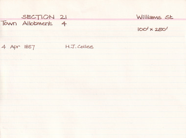
 The Beechworth Burke Museum Research Collection
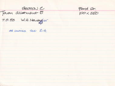
Card - Index Card, George Tibbits, Ford Street, Beechworth, 1976
Property - Ford Street (Star Hotel), Beechworth - Section 2, Town Allotment 5 - 100' x 250' Ownership details and history - 7 Sept 1853 - W.H. Neuber Architectural - Note: for all entries see Section 2, Town Allotment 4 Index Card - Brian Pump and Tony Dugan - Photographers beechworth, george tibbits -
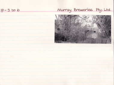
 The Beechworth Burke Museum Research Collection
Card (Series) - Index Card, George Tibbits, Ford Street, Beechworth, 1976
George Tibbits, University of Melbourne. Faculty of Architecture, Building and Town & Regional PlanningIndex system that support the research for Beechworth : historical reconstruction / [by] George Tibbits ... [et al]Arranged by street names of BeechworthEach index card includes: street name and number of property, image of property, allotment and section number, property owners and dates of ownership, description of the property according to rate records, property floor plan with dimensions.beechworth, george tibbitsbeechworth, george tibbits -
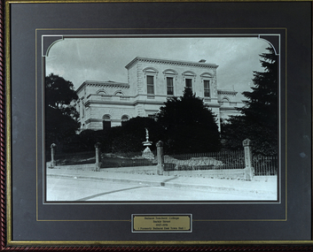 Federation University Historical Collection
Photograph - Framed photographed, Ballarat Teachers' College Barkly Street
The Ballarat Teachers' College opened at Dana Street Primary School in 1926. From 1927-1931 it was conducted at the Ballarat East Town Hall. Returning to Dana Street Primary School in 1946 to 1955, and eventually was held in a costume built facility in Gillies street from 1955 to 1976. In 1976 pre-service teacher training was moved to the Ballarat College of Advanced Education at Mt Helen Campus. This image was hung in the corridor of the School of Education (Mount Helen). It most probably dates from around the time of the transfer of Ballarat Teachers' College to the Mount Helen Campus of the Ballarat College of Advanced Education. Framed black and white photograph with green mount. The photograph shows the Former Ballarat East Town Hall during the era it was used as the Ballarat Teachers' CollegeOn a plaque ' Ballarat Teachers' College, Barkly Street, 1927-1931, (Formerly Ballarat East Town Hall)education, ballarat teachers college, ballarat east town hall, barkly street, ballarat east gardens -
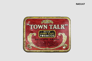 Whitehorse Historical Society Inc.
Container - Tobacco Tin
From the Collection of Charles Henry HonybunRed "Town Talk" tin to hold tobacco. Delicate aroma. Delicate Blend of high class & carefully selected tobaccos"Town Talk" mild fine cut tobaccocharles honybun -
 Port Melbourne Historical & Preservation Society
Book - Town of Port Melbourne, Contracts, 1900
Town of Port Melbourne contracts number 804 to 943 between 10.11.1903 and 20.09.1914. On inside cover details of printers and "No 89571 10.11.03"Contract Register, Town of Port Melbourne (on spine)local government - town of port melbourne -
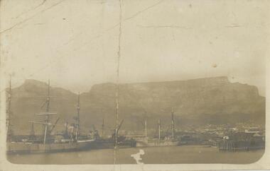 Bendigo Historical Society Inc.
Postcard - GLADYS DEAN COLLECTION: POSTCARD, 1906 - 1908
Photographic postcard depicting Table Mountain Cape Town. The front shows several ships docked in the bay. The post card is unaddressed In pencil on the back "Table Mountain Cape Town" postcard, southafrica, cape town, table mountain -
Clunes Museum
Film - VIDEO, AUSTRALIAN BROADCASTING CORPORATION
VIDEO OF CLUNES MADE BY THE AUSTRALIAN BROADCASTING CORPORATION IN 1965 - FEATURING LOCAL CITIZENS THEO HARDEN, ROBERT DOLAN & GOTTFRIED KELLER..1 VIDEO - TITLED "REBIRTH OF A GOLD TOWN" IN PLASTIC COVER .2 PHOTOCOPY OF LETTER TO THE EDITOR, WRITTEN BY W.C. FOULKES IN RESPONSE TO INTERVIEW TECHNIQUES USED IN THE VIDEO "REBIRTH OF A GOLD TOWN" .3 PHOTOCOPY OF AN ARTICLE IN THE CLUNES-TALBOT GUARDIAN DATED FRIDAY, JUNE 11, 1965ABC ARCHIVES - REBIRTH OF A GOLD TOWN TX: 1965local history, performing arts, television, video -
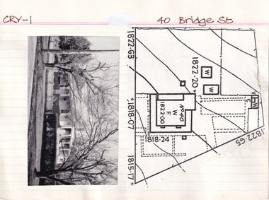 The Beechworth Burke Museum Research Collection
Card (Series) - Index Card, George Tibbits, 40 Bridge Street, Beechworth, 1976
George Tibbits, University of Melbourne. Faculty of Architecture, Building and Town & Regional PlanningIndex system that support the research for Beechworth : historical reconstruction / [by] George Tibbits ... [et al]Arranged by street names of BeechworthEach index card includes: street name and number of property, image of property, allotment and section number, property owners and dates of ownership, description of the property according to rate records, property floor plan with dimensions.beechworth, george tibbitsbeechworth, george tibbits -
 8th/13th Victorian Mounted Rifles Regimental Collection
Photograph - 8th Light Horse Violet Town 1906
Following Federation a number of companies of Victorian Mounted Rifles were consolidated to form the 8th Light Horse (VMR). In 1912 the regiment was re-titled 16th Light Horse (Indi Light Horse). In 1920 another re-numbering took place with the regiment becoming 8th Light Horse (Indi Light Horse).Badly faded photograph of group of soldiers of 8th Light Horse (VMR) in Violet Town 1906.Violet Town 1906. Sgt W Luscombe left kneelingmilitary, vmr, light horse, violet town, luscombe -
 The Beechworth Burke Museum Research Collection
Card (Series) - Index Card, George Tibbits, William Street, Beechworth, 1976
George Tibbits, University of Melbourne. Faculty of Architecture, Building and Town & Regional PlanningIndex system that support the research for Beechworth : historical reconstruction / [by] George Tibbits ... [et al]Arranged by street names of BeechworthEach index card includes: street name and number of property, image of property, allotment and section number, property owners and dates of ownership, description of the property according to rate records, property floor plan with dimensions.beechworth, george tibbitsbeechworth, george tibbits -
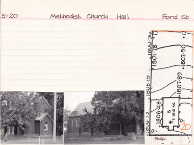 The Beechworth Burke Museum Research Collection
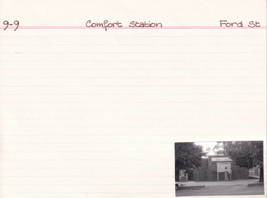
Card - Index Card, George Tibbits, Ford Street, Beechworth, 1976
Property - Methodist Church Hall - Section 5, Town Allotment 5 Ownership details and history Architectural Index Card - Brian Pump and Tony Dugan - Photographers beechworth, george tibbits -
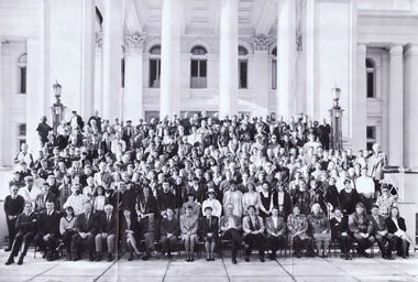 St Kilda Historical Society
Photograph - Photograph group, City of St Kilda Councillors and staff, 8 June 1994
St Kilda Town Hall Portico. Front row middle Tim Costello Mayor Jude Monrie CEO all staff last days City of St KildaBlack and white photograph copy poor condition -
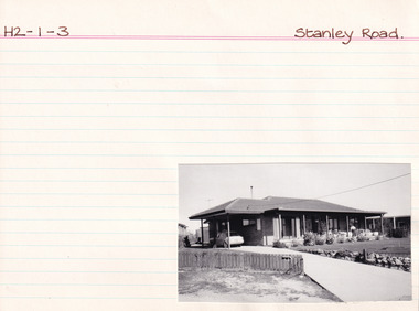
 The Beechworth Burke Museum Research Collection
Card (Series) - Index Card, George Tibbits, Stanley Road, Beechworth, 1976
George Tibbits, University of Melbourne. Faculty of Architecture, Building and Town & Regional PlanningIndex system that support the research for Beechworth : historical reconstruction / [by] George Tibbits ... [et al]Arranged by street names of BeechworthEach index card includes: street name and number of property, image of property, allotment and section number, property owners and dates of ownership, description of the property according to rate records, property floor plan with dimensions.beechworth, george tibbitsbeechworth, george tibbits -
 The Beechworth Burke Museum Research Collection
Card (Series) - Index Card, George Tibbits, Stanley Road, Beechworth, 1976
George Tibbits, University of Melbourne. Faculty of Architecture, Building and Town & Regional PlanningIndex system that support the research for Beechworth : historical reconstruction / [by] George Tibbits ... [et al]Arranged by street names of BeechworthEach index card includes: street name and number of property, image of property, allotment and section number, property owners and dates of ownership, description of the property according to rate records, property floor plan with dimensions.beechworth, george tibbitsbeechworth, george tibbits -
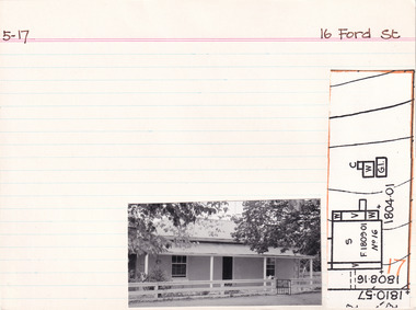 The Beechworth Burke Museum Research Collection
Card - Index Card, George Tibbits, 16 Ford Street, Beechworth, 1976
Property - 16 Ford Street, Beechworth - Section 5, Town Allotment 17 Ownership details and history Architectural Index Card - Brian Pump and Tony Dugan - Photographers beechworth, george tibbits -
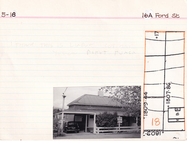 The Beechworth Burke Museum Research Collection
Card (Series) - Index Card, George Tibbits, 16A Ford Street, Beechworth, 1976
George Tibbits, University of Melbourne. Faculty of Architecture, Building and Town & Regional PlanningIndex system that support the research for Beechworth : historical reconstruction / [by] George Tibbits ... [et al]Arranged by street names of BeechworthEach index card includes: street name and number of property, image of property, allotment and section number, property owners and dates of ownership, description of the property according to rate records, property floor plan with dimensions.beechworth, george tibbitsbeechworth, george tibbits -
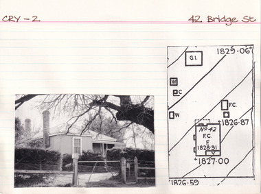 The Beechworth Burke Museum Research Collection
Card (Series) - Index Card, George Tibbits, 42 Bridge Street, Beechworth, 1976
George Tibbits, University of Melbourne. Faculty of Architecture, Building and Town & Regional PlanningIndex system that support the research for Beechworth : historical reconstruction / [by] George Tibbits ... [et al]Arranged by street names of BeechworthEach index card includes: street name and number of property, image of property, allotment and section number, property owners and dates of ownership, description of the property according to rate records, property floor plan with dimensions.beechworth, george tibbitsbeechworth, george tibbits -
 The Beechworth Burke Museum Research Collection
Card (Series) - Index Card, George Tibbits, 44 Bridge Street, Beechworth, 1976
George Tibbits, University of Melbourne. Faculty of Architecture, Building and Town & Regional PlanningIndex system that support the research for Beechworth : historical reconstruction / [by] George Tibbits ... [et al]Arranged by street names of BeechworthEach index card includes: street name and number of property, image of property, allotment and section number, property owners and dates of ownership, description of the property according to rate records, property floor plan with dimensions.beechworth, george tibbitsbeechworth, george tibbits -
 The Beechworth Burke Museum Research Collection
Card (Series) - Index Card, George Tibbits, 44A Bridge Street, Beechworth, 1976
George Tibbits, University of Melbourne. Faculty of Architecture, Building and Town & Regional PlanningIndex system that support the research for Beechworth : historical reconstruction / [by] George Tibbits ... [et al]Arranged by street names of BeechworthEach index card includes: street name and number of property, image of property, allotment and section number, property owners and dates of ownership, description of the property according to rate records, property floor plan with dimensions.beechworth, george tibbitsbeechworth, george tibbits -
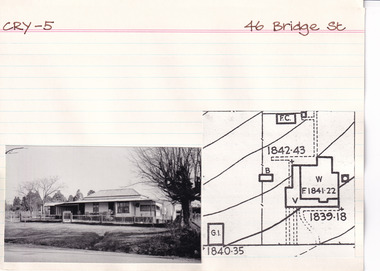 The Beechworth Burke Museum Research Collection
Card (Series) - Index Card, George Tibbits, 46 Bridge Street, Beechworth, 1976
George Tibbits, University of Melbourne. Faculty of Architecture, Building and Town & Regional PlanningIndex system that support the research for Beechworth : historical reconstruction / [by] George Tibbits ... [et al]Arranged by street names of BeechworthEach index card includes: street name and number of property, image of property, allotment and section number, property owners and dates of ownership, description of the property according to rate records, property floor plan with dimensions.beechworth, george tibbitsbeechworth, george tibbits -
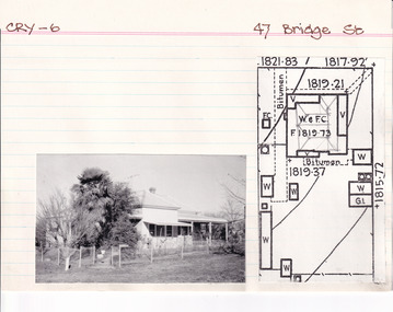 The Beechworth Burke Museum Research Collection
Card (Series) - Index Card, George Tibbits, 47 Bridge Street, Beechworth, 1976
George Tibbits, University of Melbourne. Faculty of Architecture, Building and Town & Regional PlanningIndex system that support the research for Beechworth : historical reconstruction / [by] George Tibbits ... [et al]Arranged by street names of BeechworthEach index card includes: street name and number of property, image of property, allotment and section number, property owners and dates of ownership, description of the property according to rate records, property floor plan with dimensions.beechworth, george tibbitsbeechworth, george tibbits -
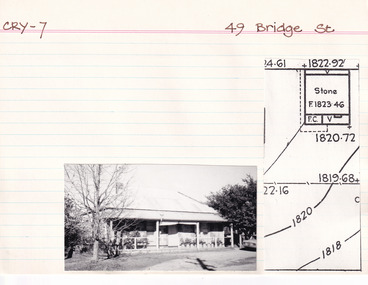 The Beechworth Burke Museum Research Collection
Card (Series) - Index Card, George Tibbits, 49 Bridge Street, Beechworth, 1976
George Tibbits, University of Melbourne. Faculty of Architecture, Building and Town & Regional PlanningIndex system that support the research for Beechworth : historical reconstruction / [by] George Tibbits ... [et al]Arranged by street names of BeechworthEach index card includes: street name and number of property, image of property, allotment and section number, property owners and dates of ownership, description of the property according to rate records, property floor plan with dimensions.beechworth, george tibbitsbeechworth, george tibbits -
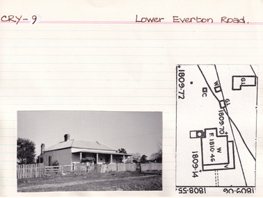 The Beechworth Burke Museum Research Collection
Card (Series) - Index Card, George Tibbits, Lower Everton Road, Beechworth, 1976
George Tibbits, University of Melbourne. Faculty of Architecture, Building and Town & Regional PlanningIndex system that support the research for Beechworth : historical reconstruction / [by] George Tibbits ... [et al]Arranged by street names of BeechworthEach index card includes: street name and number of property, image of property, allotment and section number, property owners and dates of ownership, description of the property according to rate records, property floor plan with dimensions.beechworth, george tibbitsbeechworth, george tibbits -
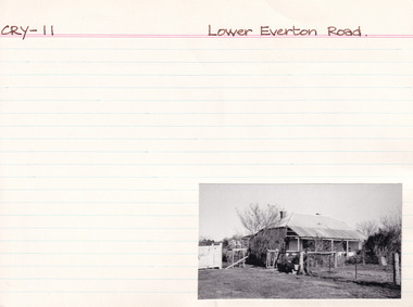 The Beechworth Burke Museum Research Collection
Card (Series) - Index Card, George Tibbits, Lower Everton Road, Beechworth, 1976
George Tibbits, University of Melbourne. Faculty of Architecture, Building and Town & Regional PlanningIndex system that support the research for Beechworth : historical reconstruction / [by] George Tibbits ... [et al]Arranged by street names of BeechworthEach index card includes: street name and number of property, image of property, allotment and section number, property owners and dates of ownership, description of the property according to rate records, property floor plan with dimensions.beechworth, george tibbitsbeechworth, george tibbits -
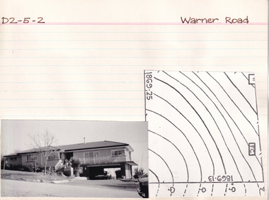 The Beechworth Burke Museum Research Collection
Card (Series) - Index Card, George Tibbits, Warner Road, Beechworth, 1976
George Tibbits, University of Melbourne. Faculty of Architecture, Building and Town & Regional PlanningIndex system that support the research for Beechworth : historical reconstruction / [by] George Tibbits ... [et al]Arranged by street names of BeechworthEach index card includes: street name and number of property, image of property, allotment and section number, property owners and dates of ownership, description of the property according to rate records, property floor plan with dimensions.beechworth, george tibbitsbeechworth, george tibbits -
 The Beechworth Burke Museum Research Collection
Card (Series) - Index Card, George Tibbits, Street number and name plus Beechworth, 1976
George Tibbits, University of Melbourne. Faculty of Architecture, Building and Town & Regional PlanningIndex system that support the research for Beechworth : historical reconstruction / [by] George Tibbits ... [et al]Arranged by street names of BeechworthEach index card includes: street name and number of property, image of property, allotment and section number, property owners and dates of ownership, description of the property according to rate records, property floor plan with dimensions.beechworth, george tibbitsbeechworth, george tibbits -
Port Melbourne Historical & Preservation Society
Plan - Fence, Sandridge Town Hall, 1877
Design for Town Hall fence, Sandridge c1877.Signed by John Stedall Robertson, Contractor and E. Clark Town Clerk:"Contract No. 332 Oct 3/77"port melbourne town hall, engineering - fences, edward clark, town clerks, sandridge town hall