Showing 3025 items matching "1930s"
-
 Australian Jazz Museum
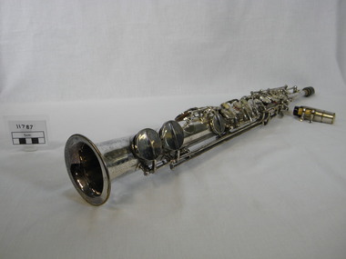
Musical Instrument, Circa 1920s
Restored by Tony Newstead. Played by Dr Phil Law during the 1930s, "for dances and other functions, while teaching at Clunes, Talbot, Creswick, Learmonth, Newtown, Smeaton, and while teaching at Elwood (at Eltham, Gisborne and Sunbury." including on many of his expeditions to the Antarctic. Phil Law was a dedicated jazz reed player and band leader in his early years as a country school teacher. His brothers also played. Gift of Dr Phil Law - 1999. Dr Law died in Melbourne on 28 February 2010 at the age of 97.Owned and played by Dr Phillip Garth (Phil) Law AC, CBE, for dances and other functions, while teaching during the 1930s, and on many of his 28 expeditions to the Antarctic. Metal Silver B flat soprano saxophone made by V. Kohlert and Sons, Graslitz, Czechoslovakia. Circa 1920s. Mother of pearl keys, slight denting. Additional mouth piece. On bell of saxophone "Kohlert Sons / Graslitz / Czechoslovakia" framed by flower and leaf motifdr phil law, dr phillip law, soprano saxophone, kohlert and sons, kohlert sons, antarctic explorer, b flat soprano saxophone, silver instrument, reed instrument -
 Federation University Historical Collection
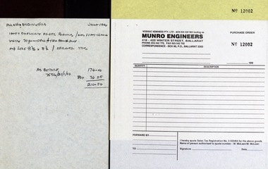
Document - Document - Purchase Order Forms, ZILLES COLLECTION: Purchase Order Forms for Munro Engineers and Gyrocast Pty Ltd, 1993 and 1994
Zilles Printers was begun by Lewis Zilles in the early 1930s. It was in McKenzie Street Ballarat. His son Jeffrey also became a printer - letterpress, offset and screen printer. The business became Zilles Printers/Graphics and was in Armstrong Street and later Bell Street Ballarat. Purchase Order forms for Munro Engineers and Gyrocast Pty Ltd with the estimates for costs related to production of these - setting up plates, press, numbering and then bind, trim and back. It also must provide a declaration section for Sales Tax and their Registration Number.Two sizes of forms - each has two sheets per order, white and yellow. White sheet has perforations to allow it to be torn out of order book. Yellow sheet retained. scrap page with estimates of costs.Munro Engineers and their address. Purchase Order Numberzilles printers, purchase order forms, munro engineers, gyrocast, cost estimates, sales tax, printing plates, numbering -
 Glen Eira Historical Society
Photograph - Elsternwick
This file contains three items. Photocopied and three page retyped article, undated c.1930s and source unknown from Real Estate Agent Philippe Batters 03/09/1997. Three page document from Keith James Smith, undated, on research on Elsternwick and Glen Huntly Road shops and traders. Three articles from THE AGE 13/05/2000 and 15-16/02/2013 and MELB BAYSIDE WEEKLY 03/11/2010 giving snap shots of Elsternwick housing and facts.batters philippe, real estate agents, elsternwick, paddocks, glen huntly road, walter kelly, elsternwick park, slaughter yards, glen eira roads, point ormond, glenhuntly railway station, nepean highway, grange road, holdsworth’s jewellers, staniland grove, coles store, shops, orrong road, fosseys, hattams mensware, woolworths, dalgarnos crockery and kitchenware, chapmans gifts, garth’s shoe store, garth jack, allen’s furniture and auction rooms, elsternwick market, adam’s cakes, mr. green’s pet shop, turner mr., grocer shop, moores lendring library, hopetown gardens, gardens, jack hatheralls butchershop, butchers, chinese laundry, chinese community, laundries, mr. & mrs. darbyshires milkbar, st. johns church, kooyong road, hasseles garage, garages, royal parade, glenhuntly, camden, hawthorn road, blacksmiths, camden town, dolls hospital, caulfield state school 773, independent picture, theatres, camden theatre, southern indoor bowl centre, larch street, montessorie school, collins milk bar, milk bars, collins lin, hartrick miss, armond mr., lennie mr., rothells sausage factory, north road, red bus service transport, furlonger miss, dance studio, moran and cato grocery, cato family, newsagent, tozer brook, furniture store, green gables american style soda fountain and milk bar, hoyts renown theatre, state savings bank, riddell parade, clarence street, aileen avenue, smith keith james, camden town, sports club, peer gary, gary peer & associates, brukarz jack, ray white real estate, real estate agents, classic cinema theatres, st. george’s road, elizabeth street, allison road, gladstone park, myrtle street, victoria street, caulfield, st kilda east, lisbon house, orrong road, house names, rippon lea estate, caulfield south, carnegie, gordon street, carre street, main street, clarence street, elsternwick club, jewish holocaust museum, daily planet, brothels, wesley college, elsternwick primary, st. joseph’s primary, scholem aleichen college, liebler yavneh, hopetoun gardens, harleston park -
 Royal Australian and New Zealand College of Obstetricians & Gynaecologists (RANZCOG)
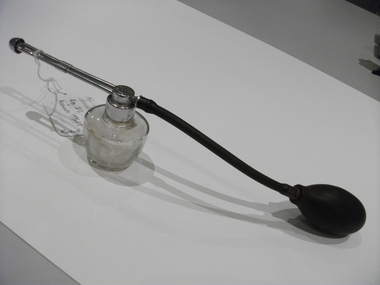
'Atomist' atomiser associated with Dr Frank Forster
The all purpose 'Atomist' atomiser was used from the 1930s to the late 1960s. The atomiser had a detachable nasal mount, and a rubber bulb which was attached to a length of tubing. It also had an adjustable spray tip. It could be used as an anaesthetic cocaine or other spray. In the 1950s it was in extensive use as a laryngeal, nasal and throat spray. The spray nozzle could be turned upwards or downwards and was similar in appearance to the De Villiers Canadian spray. The atomiser could also be used as a vaginal douche with lotion for the treatment of vaginal infections. An atomizer spray consisting of a glass container with a hollow metal tube at front and long black rubber tubing attached to a rubber bulb at the rear. Glass container has residue of white liquid in it. WARNIING: dried white powdery substance may be arsenic. Contained in sealed bag. Handle wearing nitrile gloves and ensure examination is in open area, not enclosed space. -
 National Wool Museum
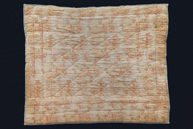
Quilt, Commercially made quilt
Commercially made quilt, c.1930s. Maker unknown, found in Ballarat. The Country Women's Association of Victoria had been active during the Depression in promoting the use of wool in domestic items and handcrafts in its "Handcrafts and Home Industries Committee". In 1933 during "Wool Week", a train jointly sponsored by the Wool Board, toured the state demonstrating amongst other crafts, the making of wool quilts and mattresses. Commercially made quilts much like this one marketed as 'Kosy Quilts', were used in these demonstrations.Quilt, plain light blue cotton cover with lambs wool filler. Machine sewn. Evidence of a label can be seen at one corner, however it has been removed.quilting history, textile mills, running stitch group, running stitch collection, ballarat, quilting - history -
Queenscliffe Maritime Museum
Leisure object - Model Blue Nose I, Clive Barnard, 1982
Bluenose I was a fishing and racing gaff rig schooner built in 1921 in Nova Scotia, Canada. A celebrated racing ship and fishing vessel, Bluenose under the command of Angus Walters, became a provincial icon for Nova Scotia and an important Canadian symbol in the 1930s, serving as a working vessel until she was wrecked in 1946. Nicknamed the "Queen of the North Atlantic", she was later commemorated by a replica, Bluenose II, built in 1963. The name Bluenose originated as a nickname for Nova Scotians from as early as the late 18th century.Scale model of Bluenose Imodel, schooner, blue nose i, nova scotia, canada -
 Ballarat Tramway Museum
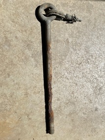
Equipment - Part of overhead - corroded eye bolt, 2024
Item show corrosion of part of the eye bolt that supports the overhead in Wendouree Parade that has occurred primarily around the screw thread. Also shows how the span wire is terminated around a thimble that is fitted to the eye bolt. The item was probably erected by the SEC during the mid-1930s and replaced by the BTM 2024. Salvaged from Wendouree Parade during overhead span wire replacement and repair work in March 2024 undertaken by the BTM. See also item 9019 for a corroded section of span wire around insulators.Demonstrates a corroded eye bolt and associated parts.Overhead equipment - galvanised eye bolt with screw thread - partly corroded with left over wire around a galvanised thimbleoverhead, span wires, btm, tramways, poles -
 Bendigo Historical Society Inc.
Ephemera - The Sun Newspaper Sunbeams Club Envelopes and Awards, 1943
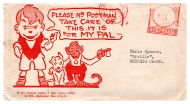
Parry Collection ‘Sunbeams’ and ‘Corinella’ were two of the few ways an Australian kid could get some acknowledgement and a pat on the back from the big wide world from the 1930s through to the 1950s. The Corinella columns ran in the Sun Newspaper with puzzles, jokes and colouring competitions. Kath Farmer played the role of ‘Corinella’ for yonks and hosted annual ‘Corinella’ Parties for boys and girls aged 5 to 13 years for decades. Sunbeam Certificates were awarded to young readers for good puzzles, riddles, drawings or original stories or verses. The Sun Newspaper Sunbeams Club Envelopes and Awards, envelopes with Ginger Meggs effigy and warning for the postman to take care with the delivery; various certificates received in return for colouring competitions and puzzles submitted back to the Sun Newspaper. Letters were sent to Merle Symons, Orville, Murphys Creek.history, bendigo, sunbeam club sun newspaper, merle lummis collection -
 Kew Historical Society Inc
Photograph - Brick and Stucco Bungalow, J E Barnes, c.1920
The Kew Historical Society's map collection includes a substantial number of real estate subdivision plans, mainly of Kew but also of surrounding suburbs in Melbourne. Most of the subdivision plans date from the 1920s and 1930s when the districts old homes and local farmland were being split up to accommodate residential growth in the postwar period. These early plans were assembled by a local firm, Jas R Mather & McMillan, which had an office in Cotham Road. Many of the plans, and sometimes photos, were annotated by the agents.Subdivision plans are historically important documents used as evidence for the growth of suburbs in Australia. They frequently provide information about when the land was sold as well as evidence relating to surveyors and real estate and financial agents. The numerous subdivision plans in the Kew Historical Society's collection represent working documents, ranging from the initial sketches made in planning a subdivision to printed plans on which auctioneers or agents listed the prices for which individual lots were sold. In a number of cases, the reverse of a subdivision plan in the collection includes a photograph of a house that was also for sale by the agent. These photographs provide significant heritage information relating house design and decoration, fencing and household gardens.The photograph may also be aesthetically significant depending o the importance of the photographic atelier.Real estate photograph for a local agent by the Kew photographer, Josiah Earl Barnes. The photo is of a weatherboard or brick rendered bungalow with a twisted wire fence. Given Barnes' status a a Kew photographer, the house is probably locate din Kew or East Kew. Unfortunately the handwritten information on the mount bordering the photo is damaged and cannot be read. The bungalow has a gabled, tiled roof with terra cotta finials at the front of both gables. The house has a central doorway, framed by a pseudo portico supported by four wooden columns. On each side of the doorway, at the front, there are paired sash windows, which, like the half-timbered gable, are picked out in a darker colour.Handwritten, mostly illegible description by selling agent on mount surround: " .... in Diningroom, Drawing Rooms, ... Photographers details printed on mount: "J. E. Barnes / Photo / Phone 1966 Haw KEW"houses - kew, bungalows - kew, real estate photographs, j.e. barnes -- photographer -
 Kew Historical Society Inc
Photograph - Victorian Double-fronted Brock Villa, Cotham Road, c. 1919
The Kew Historical Society's map collection includes a substantial number of real estate subdivision plans, mainly of Kew but also of surrounding suburbs in Melbourne. Most of the subdivision plans date from the 1920s and 1930s when the districts old homes and local farmland were being split up to accommodate residential growth in the postwar period. These early plans were assembled by a local firm, Jas R Mather & McMillan, which had an office in Cotham Road. Many of the plans, and sometimes photos, were annotated by the agents.Subdivision plans are historically important documents used as evidence for the growth of suburbs in Australia. They frequently provide information about when the land was sold as well as evidence relating to surveyors and real estate and financial agents. The numerous subdivision plans in the Kew Historical Society's collection represent working documents, ranging from the initial sketches made in planning a subdivision to printed plans on which auctioneers or agents listed the prices for which individual lots were sold. In a number of cases, the reverse of a subdivision plan in the collection includes a photograph of a house that was also for sale by the agent. These photographs provide significant heritage information relating house design and decoration, fencing and household gardens.The photograph may also be aesthetically significant depending o the importance of the photographic atelier.Real estate photographs of a classic double-fronted late Victorian brick villa. It central location in Cotham Road, Kew enabled the selling agent to note its proximity to the tram. With seven rooms, all ‘modern conveniences’, and land of 66×167, the house was to be sold for £1100. The villa has a number of interesting features including a pattern within the slate roof as well as the use of polychrome brickwork under the eaves and on the façade. The intricacy of the cast iron lace is emphasised by the line of projecting wooden blocks above it. The picket gate is painted a different colour to the pickets of the fence. The house has a name (illegible) that is attached to the inset cast iron lace of the central projecting gable in the veranda. Stamped on mount: "Kew. Central. Close tram. / Comfortable Brick Villa. / Containing 7 rooms / Modern conveniences: / Land 66 x 167. Sold 1100 pounds:"houses - kew, victorian villas, real estate photographs, cotham road - kew -
 Kew Historical Society Inc
Photograph - Double-fronted Edwardian Villa, c.1918
The Kew Historical Society's map collection includes a substantial number of real estate subdivision plans, mainly of Kew but also of surrounding suburbs in Melbourne. Most of the subdivision plans date from the 1920s and 1930s when the districts old homes and local farmland were being split up to accommodate residential growth in the postwar period. These early plans were assembled by a local firm, Jas R Mather & McMillan, which had an office in Cotham Road. Many of the plans, and sometimes photos, were annotated by the agents.Subdivision plans are historically important documents used as evidence for the growth of suburbs in Australia. They frequently provide information about when the land was sold as well as evidence relating to surveyors and real estate and financial agents. The numerous subdivision plans in the Kew Historical Society's collection represent working documents, ranging from the initial sketches made in planning a subdivision to printed plans on which auctioneers or agents listed the prices for which individual lots were sold. In a number of cases, the reverse of a subdivision plan in the collection includes a photograph of a house that was also for sale by the agent. These photographs provide significant heritage information relating house design and decoration, fencing and household gardens.The photograph may also be aesthetically significant depending on the importance of the photographic atelier.On the reverse of a subdivision plan of the Palmyra Estate (Kew) is a photograph of a double-fronted Edwardian villa. The weatherboard and stucco house with high brick chimneys provides a clear indication of the style of curtains and gardens in houses of the period. Holland blinds with lace inserts are used in the left front window. They are combined with long lace curtains. The garden, with its curved pathway is bordered with garden beds that include marguerite daisies and roses. Reflecting a new interest in the Australian landscape, tree ferns and ground ferns are planted closer to the house.houses - kew, architecture - edwardian, real estate photographs -
 Kew Historical Society Inc
Plan - Subdivision : Cotham and Glenferrie Roads, J R Mathers & McMillan
The Kew Historical Society's map collection includes a substantial number of real estate subdivision plans, mainly of Kew but also of surrounding suburbs in Melbourne. Most of the subdivision plans date from the 1920s and 1930s when the districts old homes and local farmland were being split up to accommodate residential growth in the postwar period. These early plans were assembled by a local firm, Jas R Mather & McMillan, which had an office in Cotham Road. Many of the plans, and sometimes photos, were annotated by the agents.Subdivision plans are historically important documents used as evidence for the growth of suburbs in Australia. They frequently provide information about when the land was sold as well as evidence relating to surveyors and real estate and financial agents. The numerous subdivision plans in the Kew Historical Society's collection represent working documents, ranging from the initial sketches made in planning a subdivision to printed plans on which auctioneers or agents listed the prices for which individual lots were sold. In a number of cases, the reverse of a subdivision plan in the collection includes a photograph of a house that was also for sale by the agent. These photographs provide significant heritage information relating house design and decoration, fencing and household gardens.The photograph may also be aesthetically significant depending on the importance of the photographic atelier.An undated and untitled hand-drawn and coloured subdivision plan detailing the boundaries of a number of irregular allotments bordering Cotham Road, Glenferrie Road and Stirling Avenue (now Stirling Street). The plan predates the actual subdivision that led to the creation of the eight commercial properties occupying 118-132 Cotham Road. The plan may represent an old subdivision that was further subdivided at a later date, or it may be a subdivision that never eventuated. On MMBW Detail Plan 1575 (1903), the area represented by the proposed subdivision was residential rather than commercial. The irregularity of lots is also apparent in the MMBW Plan. The largest of the unnumbered blocks on the hand-drawn subdivision plan may relate to the boundaries of the nineteenth century mansion identified as ‘Kelso’ on the MMBW Plan.subdivision plans - kew, cotham road - kew,, glenferrie road - kew , stirling avenue street - kew -
 Kew Historical Society Inc
Photograph - Cottage, probably East Kew, A. Aberline, 1920s
The Kew Historical Society's map collection includes a substantial number of real estate subdivision plans, mainly of Kew but also of surrounding suburbs in Melbourne. Most of the subdivision plans date from the 1920s and 1930s when the districts old homes and local farmland were being split up to accommodate residential growth in the postwar period. These early plans were assembled by a local firm, Jas R Mather & McMillan, which had an office in Cotham Road. Many of the plans, and sometimes photos, were annotated by the agents.Subdivision plans are historically important documents used as evidence for the growth of suburbs in Australia. They frequently provide information about when the land was sold as well as evidence relating to surveyors and real estate and financial agents. The numerous subdivision plans in the Kew Historical Society's collection represent working documents, ranging from the initial sketches made in planning a subdivision to printed plans on which auctioneers or agents listed the prices for which individual lots were sold. In a number of cases, the reverse of a subdivision plan in the collection includes a photograph of a house that was also for sale by the agent. These photographs provide significant heritage information relating house design and decoration, fencing and household gardens.The photograph may also be aesthetically significant depending on the importance of the photographic atelier.An elevated, modest weatherboard house, photographed towards the end of the construction phase. The lower section of the weatherboards are exposed and stained. The upper section is rendered with rough-cast. The tiled roof has a single gable that extends over the centrally placed front porch. On the porch, the door and single sidelight are filled with coloured leadlight whereas the casement windows in the front rooms contain plain glass. The leadlight and the wrought iron of the verandah are the only decorative elements of the utilitarian design. The location of the house, which was advertised for sale, has not to date been identified. The real estate photograph is mounted on the reverse of a subdivision plan for the Harvest Home Estate, Kew East.Photographer's stamp, lower right on mount: "A. Aberline, Glenferrie"houses - kew, bungalows - kew, real estate photographs -
 Kew Historical Society Inc
Photograph - Bungalow, probably East Kew, 1920s
The Kew Historical Society's map collection includes a substantial number of real estate subdivision plans, mainly of Kew but also of surrounding suburbs in Melbourne. Most of the subdivision plans date from the 1920s and 1930s when the districts old homes and local farmland were being split up to accommodate residential growth in the postwar period. These early plans were assembled by a local firm, Jas R Mather & McMillan, which had an office in Cotham Road. Many of the plans, and sometimes photos, were annotated by the agents.Subdivision plans are historically important documents used as evidence for the growth of suburbs in Australia. They frequently provide information about when the land was sold as well as evidence relating to surveyors and real estate and financial agents. The numerous subdivision plans in the Kew Historical Society's collection represent working documents, ranging from the initial sketches made in planning a subdivision to printed plans on which auctioneers or agents listed the prices for which individual lots were sold. In a number of cases, the reverse of a subdivision plan in the collection includes a photograph of a house that was also for sale by the agent. These photographs provide significant heritage information relating house design and decoration, fencing and household gardens.The photograph may also be aesthetically significant depending on the importance of the photographic atelier.An unusual bungalow that does not conform to a particular architectural style but which contains eclectic elements of the style of varying periods. The most striking element of the design is the cantilevered veranda that is supported by heavy chains that are attached to the central gable. This deep gable extends across most of the façade, forming an extensive veranda. Parts of this are infilled with screens. Seven wooden posts, whose lower halves are encased in rendered brick pillars, support this gabled veranda. The roof would appear to be covered with corrugated iron. The location of the house, which was advertised for sale, has to date not been identified. The real estate photo is on the reverse of a plan for the Myrtle Hill Subdivision, Kew.bungalows - kew, architecture - 1920s, real estate photographs -
 Kew Historical Society Inc
Plan - Subdivision Plan, J R Mathers & McMillan, Myrtle Hill Estate, East Kew, circa 1949, c.1949
The Kew Historical Society's map collection includes a substantial number of real estate subdivision plans, mainly of Kew but also of surrounding suburbs in Melbourne. Most of the subdivision plans date from the 1920s and 1930s when the districts old homes and local farmland were being split up to accommodate residential growth in the postwar period. These early plans were assembled by a local firm, Jas R Mather & McMillan, which had an office in Cotham Road. Many of the plans, and sometimes photos, were annotated by the agents.Subdivision plans are historically important documents used as evidence for the growth of suburbs in Australia. They frequently provide information about when the land was sold as well as evidence relating to surveyors and real estate and financial agents. The numerous subdivision plans in the Kew Historical Society's collection represent working documents, ranging from the initial sketches made in planning a subdivision to printed plans on which auctioneers or agents listed the prices for which individual lots were sold. In a number of cases, the reverse of a subdivision plan in the collection includes a photograph of a house that was also for sale by the agent. These photographs provide significant heritage information relating house design and decoration, fencing and household gardens.The photograph may also be aesthetically significant depending on the importance of the photographic atelier.Myrtle Hill, at 14 Vista Avenue, Kew, is of local historical and architectural significance as a good example of a large and imposing single-storey Italianate house of the early 1870s surviving in Kew. Originally sited on a large allotment overlooking Normanby Road, the setting of the house has been dramatically altered through extensive subdivision and development. The subdivision plan of the ‘Myrtle Hill Estate’ indicates that in one such subdivision, 11 allotments were created fronting Bowyer Avenue, Myrtle Avenue, and Normanby Road. The outline and building profile of Myrtle Hill is shown on the west side of Bowyer Avenue.The full (typed) title of this subdivision plan is :"Plan of SUBDIVISION of part of CROWN PORTION 83. / at KEW / PARISH OF BOROONDARA. / COUNTY OF BOURKE". / "MYRTLE HILL ESTATE / EAST KEW" In addition to the Title and subtitle, the plan also lists the advantages of the subdivision. -
 Kew Historical Society Inc
Plan - Subdivision Plan, J R Mathers & McMillan, Normanby Estate, c.1913
The Kew Historical Society's map collection includes a substantial number of real estate subdivision plans, mainly of Kew but also of surrounding suburbs in Melbourne. Most of the subdivision plans date from the 1920s and 1930s when the districts old homes and local farmland were being split up to accommodate residential growth in the postwar period. These early plans were assembled by a local firm, Jas R Mather & McMillan, which had an office in Cotham Road. Many of the plans, and sometimes photos, were annotated by the agents.Subdivision plans are historically important documents used as evidence for the growth of suburbs in Australia. They frequently provide information about when the land was sold as well as evidence relating to surveyors and real estate and financial agents. The numerous subdivision plans in the Kew Historical Society's collection represent working documents, ranging from the initial sketches made in planning a subdivision to printed plans on which auctioneers or agents listed the prices for which individual lots were sold. In a number of cases, the reverse of a subdivision plan in the collection includes a photograph of a house that was also for sale by the agent. These photographs provide significant heritage information relating house design and decoration, fencing and household gardens.The photograph may also be aesthetically significant depending on the importance of the photographic atelier.The Normanby Estate, which was adjacent to Normanby Road, Kew East, included thirty-one lots for sale. Streets on the subdivision plan include Adeney Avenue, Park Hill Road, Normanby Road, Weir Street and Wharton Street. Cotham Road and its tramway are shown nearby. The plan is interesting as it shows Wharton Street, named after the architect and town planner George Wharton, who was the first chairman of the Municipality of Kew. The street was to later be renamed Cecil Street. Also shown are proposed ‘Municipal Gardens’ where Parkhill Drive is now located."D" in top left corner. Stamped auctioneers contact details: "Jas. R. Mathers & Son & McMillan / Auctioneer & Land Salesmen, / 271 Collins Street / Melbourne" and Jas. R. Mathers / Estate & Financial Agent / Cotham Road / Kew".weir street - kew, wharton street - kew, normanby road - kew, cotham road - kew, municipal gardens - kew, park hill parkhill road - kew, braemar - kew, subdivision plans - kew -
 Kew Historical Society Inc
Plan, J R Mathers & McMillan, Sackville, Thomas & Lytton Streets, Kew, Twentieth Century
The Kew Historical Society's map collection includes a substantial number of real estate subdivision plans, mainly of Kew but also of surrounding suburbs in Melbourne. Most of the subdivision plans date from the 1920s and 1930s when the districts old homes and local farmland were being split up to accommodate residential growth in the postwar period. These early plans were assembled by a local firm, Jas R Mather & McMillan, which had an office in Cotham Road. Many of the plans, and sometimes photos, were annotated by the agents.Subdivision plans are historically important documents used as evidence for the growth of suburbs in Australia. They frequently provide information about when the land was sold as well as evidence relating to surveyors and real estate and financial agents. The numerous subdivision plans in the Kew Historical Society's collection represent working documents, ranging from the initial sketches made in planning a subdivision to printed plans on which auctioneers or agents listed the prices for which individual lots were sold. In a number of cases, the reverse of a subdivision plan in the collection includes a photograph of a house that was also for sale by the agent. These photographs provide significant heritage information relating house design and decoration, fencing and household gardens.The photograph may also be aesthetically significant depending on the importance of the photographic atelier.Lithographed subdivision plan for an un-named estate with 28 allotments facing Lytton, Sackville and Thomas Streets in Kew. The land would have originally formed part of the Dumaresq Estate. subdivision plans - kew, lytton street, sackville street, thomas street - kew -
 Kew Historical Society Inc
Plan - Subdivision Plan, Jas R Mathers Son & McMillan, Eastlawn Estate : East Kew Auction Sale, 1914
The Kew Historical Society's map collection includes a substantial number of real estate subdivision plans, mainly of Kew but also of surrounding suburbs in Melbourne. Most of the subdivision plans date from the 1920s and 1930s when the districts old homes and local farmland were being split up to accommodate residential growth in the postwar period. These early plans were assembled by a local firm, Jas R Mather & McMillan, which had an office in Cotham Road. Many of the plans, and sometimes photos, were annotated by the agents.Subdivision plans are historically important documents used as evidence for the growth of suburbs in Australia. They frequently provide information about when the land was sold as well as evidence relating to surveyors and real estate and financial agents. The numerous subdivision plans in the Kew Historical Society's collection represent working documents, ranging from the initial sketches made in planning a subdivision to printed plans on which auctioneers or agents listed the prices for which individual lots were sold. In a number of cases, the reverse of a subdivision plan in the collection includes a photograph of a house that was also for sale by the agent. These photographs provide significant heritage information relating house design and decoration, fencing and household gardens.The photograph may also be aesthetically significant depending on the importance of the photographic atelier.The ‘Eastlawn Estate’ was surveyed and ready for auction in March 1914, three months before the outbreak of World War I. Sixty-six allotments, created on the ‘order of Mr & Miss Preston’ surrounded the mansion of Woodlands in Harp Road. Woodlands formed part of the Estate, being advertised as lot 1. The allotments faced High, Station and Wright Streets, Harp and Normanby Roads, and Woodlands Avenue. Pru Sanderson in the Kew Conservation Study (Vol.2, 1988) wrote that the Eastlawn Estate ‘covered the western half of the failed Harp of Erin Estate’. Contemporary advertisements promoted the Eastlawn Estate as: ‘There will be no more convenient district nor pleasant Suburb than East Kew for the busy business man. When the Electric Tram is laid, he will be able to journey quickly and pleasantly direct from Collins Street to his home in the Eastlawn Estate in about 20 minutes’. The actual plans of subdivision were included in advertisements in The Argus and in the local newspapers."C" top left. Various annotations.subdivision plans - kew, station street, normanby road, high street, woodlands avenue, harp road, woodlands - kew -
 Kew Historical Society Inc
Plan - Subdivision Plan, Winton Estate, East Kew : Sale of 10 Building Blocks, 1920
The Kew Historical Society's map collection includes a substantial number of real estate subdivision plans, mainly of Kew but also of surrounding suburbs in Melbourne. Most of the subdivision plans date from the 1920s and 1930s when the districts old homes and local farmland were being split up to accommodate residential growth in the postwar period. These early plans were assembled by a local firm, Jas R Mather & McMillan, which had an office in Cotham Road. Many of the plans, and sometimes photos, were annotated by the agents.Subdivision plans are historically important documents used as evidence for the growth of suburbs in Australia. They frequently provide information about when the land was sold as well as evidence relating to surveyors and real estate and financial agents. The numerous subdivision plans in the Kew Historical Society's collection represent working documents, ranging from the initial sketches made in planning a subdivision to printed plans on which auctioneers or agents listed the prices for which individual lots were sold. In a number of cases, the reverse of a subdivision plan in the collection includes a photograph of a house that was also for sale by the agent. These photographs provide significant heritage information relating house design and decoration, fencing and household gardens.The photograph may also be aesthetically significant depending on the importance of the photographic atelier.Subdivision plan for the so-called Winton Estate in East Kew. The Estate comprised 10 lots facing Simpson Street and Campbell Street. The estate was auctioned by Jas. R. Mathers, Son and McMillan. campbell street, simpson street, hunter street, normanby road - kew, subdivision plans - east kew, subdivision plans - kew -
![7 Roomed Brick [villa]; Modern Conveniences](/media/collectors/550653872162f11fb04854aa/items/59ec3da221ea690fdc4ba793/item-media/59ec3ee521ea690fdc4d0c37/item-fit-380x285.jpg) Kew Historical Society Inc
Kew Historical Society IncPhotograph - 7 Roomed Brick [villa]; Modern Conveniences, 1920s
The Kew Historical Society's map collection includes a substantial number of real estate subdivision plans, mainly of Kew but also of surrounding suburbs in Melbourne. Most of the subdivision plans date from the 1920s and 1930s when the districts old homes and local farmland were being split up to accommodate residential growth in the postwar period. These early plans were assembled by a local firm, Jas R Mather & McMillan, which had an office in Cotham Road. Many of the plans, and sometimes photos, were annotated by the agents.Subdivision plans are historically important documents used as evidence for the growth of suburbs in Australia. They frequently provide information about when the land was sold as well as evidence relating to surveyors and real estate and financial agents. The numerous subdivision plans in the Kew Historical Society's collection represent working documents, ranging from the initial sketches made in planning a subdivision to printed plans on which auctioneers or agents listed the prices for which individual lots were sold. In a number of cases, the reverse of a subdivision plan in the collection includes a photograph of a house that was also for sale by the agent. These photographs provide significant heritage information relating house design and decoration, fencing and household gardens.The photograph may also be aesthetically significant depending on the importance of the photographic atelier.A professionally produced photograph for a local real estate agent, probably Jas. R. Mathers, Son & McMillan. The photograph is of a Federation-era bungalow, in Kew. The photo is on the reverse of a subdivision plan for the Normanby Heights Estate, Kew.The mount on which the photograph is placed includes: "Kew. 1 minute to tram. Good Position. / 7 roomed brick. Modern conveniences. / Land 60 x 135. 1100 pounds"real estate photographs, houses - kew, federation architecture -
 Kew Historical Society Inc
Plan - Subdivision Plan, Argyle Road, Heather Grove, Victor Avenue, Kew, c.1937
The Kew Historical Society's map collection includes a substantial number of real estate subdivision plans, mainly of Kew but also of surrounding suburbs in Melbourne. Most of the subdivision plans date from the 1920s and 1930s when the districts old homes and local farmland were being split up to accommodate residential growth in the postwar period. These early plans were assembled by a local firm, Jas R Mather & McMillan, which had an office in Cotham Road. Many of the plans, and sometimes photos, were annotated by the agents.Subdivision plans are historically important documents used as evidence for the growth of suburbs in Australia. They frequently provide information about when the land was sold as well as evidence relating to surveyors and real estate and financial agents. The numerous subdivision plans in the Kew Historical Society's collection represent working documents, ranging from the initial sketches made in planning a subdivision to printed plans on which auctioneers or agents listed the prices for which individual lots were sold. In a number of cases, the reverse of a subdivision plan in the collection includes a photograph of a house that was also for sale by the agent. These photographs provide significant heritage information relating house design and decoration, fencing and household gardens.The photograph may also be aesthetically significant depending on the importance of the photographic atelier.Undated blue subdivision plan in Kew of 14 lots facing Argyle Road, Heather Grove and Victor Road. The Plan identifies Tuxen & Miller as the surveyors. [Formerly catalogued as MAP.0059]subdivision plans - kew, argyle road - kew, heather grove - kew, victor avenue - kew -
 Surrey Hills Historical Society Collection
Photograph, Ray & David Theodoridis of Russell Street, 1960s
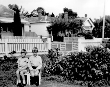
The boys have been identified as *Rea & David Theodoridis. they being 2 of 5 children of Peter and Ruth (nee Dawson) Theodoridis. Background shows Nos 11, 13 and 15 Russell Street in the 1960's. In the 1920s-1930s these were the homes of the Scott, Daniels & Hendy families. No 11 was the home of the Scott family (dem); no 13 may also have belonged to the Scott family. No 18 Russell Street, the family home of Eleanor (Lena) & Rea Dawson. * spelling authenticated by Theodata Williams Dec 2019A black and white photograph of two young boys sitting on small chairs in a front garden. There are two houses in the background on the other side of the road.russell street, surrey hills, scott family, daniels family, hendy family, (mr) david theodoridis, (mr) george david theodoridis, (mr) rae theodoridis -
 Surrey Hills Historical Society Collection
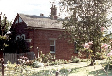
Photograph, Tavistock at 192 Union Road, 1978
The date is approximate. Tavistock was built c1890. The side windows on the front room are a later addition in a different style from the original windows. In 1897 it was the home of the Walker family; Joyce Walker later became matron of Mosgiel Hospital. In 1902 it became the first site of Milverton Girls School. From 1930s to 1960s it was home to Miss Marjorie Vahland, a locally well-known nursing sister. See History Walks No 5, p 11 and p32 Surrey Hills In Celebration of its Centennial 1883-1983Colour photo of the north side of Tavistock at 192 Union Road, Surrey Hills revealed when this side of the property was partially without a fence; taken while re-fencing. The house is Victorian in style, of red brick construction with a patterned slate tile roof and decorative chimneys.tavistock, milverton girls school, victorian style, houses, joyce walker, miss marjorie vahland, nurses -
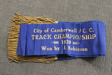 Camberwell Historical Society
Ceremonial object - Sash, City of Camberwell A.C.C. Track Championship cycling sash, 1939
Champion's sash from 1939 awarded to competitive cyclist Jack Stanley Robinson. Jack Stanley Robsinson lived in Canterbury for most of his youth and was a member of the City of Camberwell Amateur Cycling Club in the late 1930s. Jack appears in the press (NLA Trove) as a member of the Malvern cycling team in a March 1934 trial competition of “boys”, and then with increasing frequency in amateur competitions throughout 1935 to 1938. In October 1938 he appears in the Camberwell team. The last entry so far found is in December 1939, still with the Camberwell team. Blue sash with gold tassels 'City of Camberwell A.C.C. Track Championship 1939 Won by J. Robinson'cycling, sport -
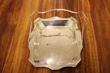 Camberwell Historical Society
Ceremonial object - Trophy tray, City of Camberwell Amateur Cycling Club silver plated tray trophy, 1939
Silver tray trophy awarded to competitive cyclist Jack Stanley Robinson in 1939. Jack Stanley Robsinson lived in Canterbury for most of his youth and was a member of the City of Camberwell Amateur Cycling Club in the late 1930s. Jack appears in the press (NLA Trove) as a member of the Malvern cycling team in a March 1934 trial competition of “boys”, and then with increasing frequency in amateur competitions throughout 1935 to 1938. In October 1938 he appears in the Camberwell team. The last entry so far found is in December 1939, still with the Camberwell team. Silver plated tray with handleInscription which reads 'CCACC 1939 Road Season'cycling, sport, trophy -
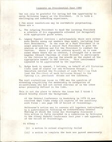 Melbourne Legacy
Document, Comments on Presidential Year 1980 - EK Robertson, 1981
The President in 1980 was Karl Robertson. A major issue for his year in office was the question of the extension of eligibility for membership to categories of ex-servicemen who had not served overseas or in the other areas presently defined in the Code. Document is dated 12/10/1981 as the presidential year ran from March to the following February and this was written sometime after he was replaced as president. Was in a binder of documents that is passed from an outgoing President to the incoming President. It is primarily from the 1930s to 1990s. Most documents are being catalogued separately.A record of the ideas of the President in the 1970s.White foolscap paper x 2 pages with black type of the President's comments in 1980.presidents, karl robertson -
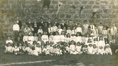 Melbourne Legacy
Photograph, From RSSILA Geelong - Christmas 1919, 1918
A group of children in Geelong who's fathers had served during the first World War. The RSSILA (precursor to the RSL) had held an event for them and took this photo which was then distributed to the families at Christmas 1919. Margaret Burn is possibly one in the front row and her family donated the photo. Margaret later attended girls classes with Geelong Legacy in the 1930s and Legacy helped her find employment when she left school. Her family donated two photos and a Laurel Badge to Legacy.A very early photo shows that Geelong RSSILA were looking after the children of soldiers.Sepia photo in a brown cardboard frame of many children taken at a RSSILA Geelong event in 1919.geelong legacy, margaret burn -
 Federation University Historical Collection
Book, William Harvey Emmons, The Principles of Economic Geology, 1940, 1940
The book was used by Charles Bacon who studied at the University of Nevada in the late 1930s/early 1940s. Bacon worked at Bunker Hill Mines and Kellogg Idaho, before arriving in Australian in 1951. He worked for CN Myers, a company involved with paper converting. CN Myers was a family business (on Charles Bacon's maternal line). William Emmons was Professor and head of Geology and Mineralogy at the University of Minnesota; Director of Minnesota geological Survey; and previously Geologist, Section of Metalliferous Deposits, United States Geological Survey.Maroon soft covered book of 529 pages. Chapters include Magmatic Segregations, Pegmatities, Hypothermal Deposits, Sedimentary Depostis, Openings in Rocks, Metasomatic Processes, Mineral Associations and more.Inside front cover "Charles Bacon 1940 Lincoln Hall Ass. University of Nevada Reno, Nevada"charles bacon, mining engineering, metallurgy, university of nevada, mackay school of mines, geology, california -
 Linton and District Historical Society Inc
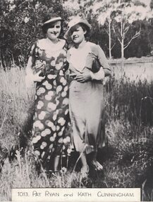
Photograph, Pat Ryan and Kath Cunningham
Pat Ryan, born 1919, was a daughter of Jim Ryan, hairdresser and tobacconist. She moved to Linton as a child in 1926 when her father bought the former Bennett/Todd shop in 1926. Katherine Veronica Cunningham was born at Cape Clear in 1907. Pat Ryan and Kath Cunningham were members of the Linton Amateur Dramatic Society in the 1930s and 1940s. (See programmes in LDHS for Amateur Dramatic Society productions.) Kath Cunningham worked at the Railway Hotel. She was on the committee which organised Linton's centenary celebrations in 1939.Enlarged black and white copy of original photograph, which shows two young women dressed stylishly, wearing hats and dress shoes. The woman on the left has a purse or small clutch bag in her hand, and the woman on the right has a handbag tucked under her arm. The photograph was taken in an outdoor setting, possibly near Linton Reservoir.pat (patricia) ryan, kath (kathleen) cunningham -
 Royal Australian and New Zealand College of Obstetricians & Gynaecologists (RANZCOG)
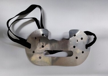
Equipment - Protective metal dust mask associated with Dr Lorna Lloyd-Green
This style of mask was developed in Britain and began to appear from the 1930s, though original models may have been produced in the 1920s. Various patents for this style of mask were still being filed in the 1960s, so they were used for a considerable period of time. It is possible that the original filter pads for these masks contained asbestos, as they supposedly utilised 'fire proof' materials. Asbestos was already in use in other British respirator masks at this time. Original cataloguing information believed this item to be an eye shield, but further research has indicated that this is not the case.Mask consists of a metal plate designed to cover the lower half of the face. There is a recess along the top edge of the plate designed for the nose to sit in. There is a large oblong opening with rounded corners at the centre of the mask, which is a mouth opening to assist speech and is the main air intake. There are five round holes on either side of the mask, likely included to decrease the mask's breathing resistance for the wearer. Rounded slots at each edge of the mask are threaded through with an elastic strap, used for attaching the mask to the face. This mask would have been used with a filtering pad attached, but the pad is missing.