Showing 2091 items
matching bendigo maps
-
 Bendigo Historical Society Inc.
Map - TALAMBE : COUNTY OF BENDIGO, January 1956
... Map. Talambe, County of Bendigo, Hayanmi, Pompapiel, Dingee... Inc. History House 11 Mackenzie Street Bendigo goldfields MAP ...Map. Talambe, County of Bendigo, Hayanmi, Pompapiel, Dingee, Tandarra, Yallook. By authority W.M. Houston, Government Printer, Melbourne. Drawn and reproduced at the Department of Lands and Survey, Melbourne. January 1956. Price 2/-. (number 8 in map cupboard 1)W.M. Houston, Government Printermap, bendigo, talambe -
Bendigo Historical Society Inc.
Map - SEDGWICK : COUNTY OF BENDIGO, 1963
... Map. Sedgwick, County of Bendigo, Strathfieldsaye, Eppalock... Inc. History House 11 Mackenzie Street Bendigo goldfields MAP ...Map. Sedgwick, County of Bendigo, Strathfieldsaye, Eppalock, Lyell, Mandurang, Sutton Grange. By Authority A.C. Brooks, Government Printer, Melbourne. Drawn and reproduced at the Deparment of Lands and Survey, Melbourne. 1963. Price 2/-. (number 7 in map cupboard 1)A.C. Brooks, Government Printer.map, bendigo, sedgwick -
Bendigo Historical Society Inc.
Map - SALISBURY : COUNTY OF BENDIGO, 1965
... Map. Salisbury, County of Bendigo, Pompapiel, Yarrayne... Inc. History House 11 Mackenzie Street Bendigo goldfields MAP ...Map. Salisbury, County of Bendigo, Pompapiel, Yarrayne, Yarraberb, Yallook, Bullock Creek. By Authority: A.C. Brooks, Government Printer, Melbourne. Drawn and reproduced at the Department of Lands and Survey, Melbourne.1965. Price $1.00. (number 6 in map cupboard 1)A.C. Brooks, Government Printermap, bendigo, salisbury -
Bendigo Historical Society Inc.
Map - RAVENSWOOD : COUNTY OF BENDIGO, 1971
... Map. Ravenswood, County of Bendigo, Township of Ravenswood... Inc. History House 11 Mackenzie Street Bendigo goldfields MAP ...Map. Ravenswood, County of Bendigo, Township of Ravenswood, County of Talbot, Bradford; Walmer; Harcourt; Lockwood; Mandurang; Sutton Grange.By Authority C.H.Rixon, Government Printer, Melbourne.Drawn and Reproduced at the Dept. of Crown Lands and Survey, Victoria. 1971. Price $1.00 (number 5 in map cupboard 1)C.H.Rixon, Government Printermap, bendigo, ravenswood -
Bendigo Historical Society Inc.
Map - POMPAPIEL : COUNTY OF BENDIGO, 1-10-27
... Map. Pompapiel, County of Bendigo, Calivil, Janiember East... Inc. History House 11 Mackenzie Street Bendigo goldfields MAP ...Map. Pompapiel, County of Bendigo, Calivil, Janiember East, Yarrayne, Salisbury, Yallook, Talambe, Judyong Creek, Bullock Creek, Pompapiel Creek, Edeyrn Estate. Photo-Lithographed at the Department of Lands and Survey, Melbourne by W.J. Butson, 1-10-27, Price 1/-. (number 4 in map cupboard 1)W.J. Butson, Government Printermap, bendigo, pompapiel -
Bendigo Historical Society Inc.
Map - PANNOOMILLOO : COUNTY OF BENDIGO, 1957
... Map. Pannoomilloo, County of Bendigo, Milloo, Warragamba... Inc. History House 11 Mackenzie Street Bendigo goldfields MAP ...Map. Pannoomilloo, County of Bendigo, Milloo, Warragamba, Diggorra, Pannoobamawm. Drawn and reproduced at the Department of Lands and Survey, Melbourne,1957. Price 2/-. By Appointment W.M. Houston, Government Printer, Melbourne. (number 3 in map cupboard 1)W.M. Houston, Government Printermap, bendigo, pannoomilloo -
Bendigo Historical Society Inc.
Map - PANNOOBAMAWM : COUNTY OF BENDIGO, 1957
... Map. Pannoobamawm, County of Bendigo. By Appointment W.M... Inc. History House 11 Mackenzie Street Bendigo goldfields MAP ...Map. Pannoobamawm, County of Bendigo. By Appointment W.M. Houston, Government Printer, Melbourne. Drawn and reproduced at the Department of Lands and Survey, Melbourne. Price 2/-.1957. Turrumberry, Terrick Terrick East, Wanurp,Pannoomilloo, Bamawm, Pannoobamawm. (number 2 in map cupboard 1)W.M. Houston, Government Printermap, bendigo, pannoobamawm -
Bendigo Historical Society Inc.
Map - NOLAN, COUNTY OF BENDOGO, 7-5-30
... Map, Nolan, County of Bendigo, Egerton; Elmore; Goornong... Inc. History House 11 Mackenzie Street Bendigo goldfields MAP ...Map, Nolan, County of Bendigo, Egerton; Elmore; Goornong. Campaspe River, Elmore Estate, By Authority: H.J.Green, Government Printer,Melbourne.Price 2/-.Drawn and Reproduced at the Dept. of Lands and Survey,Melbourne,Victoria.7-5-30. (number 1 in map cupboard 1)H.J.Green,Government Printermap, bendigo, nolan -
Bendigo Historical Society Inc.
Map - NERRING : COUNTY OF BENDIGO, August 1952
... Map. Nerring, County Of Bendigo. Yarraberb, Neilborough... Inc. History House 11 Mackenzie Street Bendigo goldfields MAP ...Map. Nerring, County Of Bendigo. Yarraberb, Neilborough, Huntly, Sandhurst, Leichardt, Marong. Drawn and reproduced at the Department of Lands and Survey, Melbourne,Victoria. August 1952, Price 2/-. By Appointment J.J. Gourley, Government Printer, Melbourne. (number 0 in map cupboard 1)J.J. Gourley,Government Printermap, bendigo, nerring -
 Bendigo Historical Society Inc.
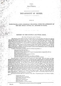
Document - STRAUCH COLLECTION: DEPT OF MINES,REPORT ON HUNTLY ALLUVIAL LEAD
1898 Victoria Department of Mines report on the Huntly Alluvial Lead with assorted maps.mining, extraction, alluvial -
 Bendigo Historical Society Inc.
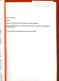
Book - STRAUCH COLLECTION: A SOCIAL HISTORY OF DIAMOND HILL AND VICINITY
Graduate diploma of regional studies history thesis submitted to La trobe University College of Northern Victoria 1992 'A Social History of Diamond Hill and vicinity 1851-1900' contains maps, graphs & black and white photographs.Diane Dougallbendigo, history, diamond hill, bendigo-history-mining -
 Bendigo Historical Society Inc.
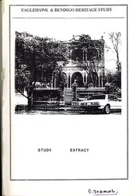
Book - STRAUCH COLLECTION: EAGLEHAWK & BENDIGO HERITAGE STUDY
Eaglehawk & Bendigo Heritage Study, study extract & steering committee response to the study, contains maps and black & white photographs.bendigo, planning, heritage -
 Bendigo Historical Society Inc.
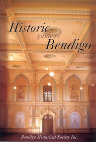
Book - STRAUCH COLLECTION: HISTORIC GUIDE TO BENDIGO
Historic guide to Bendigo, Bendigo Historical Society Inc, 60 pages with maps and black & white photographs.bendigo, history, 19th century bendigo, bendigo-history -
 Bendigo Historical Society Inc.
Document - STAFFORD REEF MINE SITE, DIAMOND HILL
One page document describing the Stafford Reef Mine Site, Diamond Hill, Site 4.11, prepared by David Bannear. Information includes the map/grid references of the site and an overview of the history of the Stafford Reef Mine. The physical remains of the mine are described..bendigo, mining, stafford reef mine -
Bendigo Historical Society Inc.
Document - DIAMOND HILL HISTORIC AREA PARKS VICTORIA
Document, two pages, prepared by Parks Victoria in relation to the Diamond Hill Historic Area. Contains information regarding the history of the area; German Miners; Plants and animals. On second page is a map of the area showing historic features: Deborah Consolidated Gold workings Red, White and Blue Extended gold workings Goldfields Extended gold workings Dead Dog Gully, alluvial gold workings Glasgow & Golconda Gold workings and tramway Surface gold mining site Hansel Mundy gold workings Bendigo Goldfields Pty gold workings Stafford gold workings Langdon gold workings Great Opossum Gully alluvial gold workingsbendigo, mining, diamond hill -
Bendigo Historical Society Inc.
Map - BENDIGO PARISH PLAN
... BENDIGO Land sales parish map Bendigo Parish Plan Section C Paper ...Bendigo Parish Plan Section C Paper with edges bound with canvas tape.bendigo, land sales, parish map -
Bendigo Historical Society Inc.
Map - BENDIGO PARISH PLAN
... BENDIGO Land sales parish map Bendigo Parish Plan Section K Map ...Bendigo Parish Plan Section Kbendigo, land sales, parish map -
Bendigo Historical Society Inc.
Map - BENDIGO PARISH PLAN
... edges. Taken from George Black's maps Map BENDIGO PARISH PLAN ...Bendigo Parish Plan Central Bendigo. Canvas with Canvas typed edges. Taken from George Black's maps -
Bendigo Historical Society Inc.
Map - STRUGNELL COLLECTION: BENDIGO GOLD FIELD GEOLOGICAL SURVEY, 1936
... BENDIGO Gold mining geological map Dept of Mines Victoria Bendigo ...Bendigo Goldfieds Geological Survey. Prepared in the Bendigo Office Bottom Section of original map.Dept of Mines Victoriabendigo, gold mining, geological map -
Bendigo Historical Society Inc.
Map - STRUGNALL COLLECTION: BENDIGO GOLD FIELD GEOLOGICAL SURVEY, 1936
... BENDIGO Gold mining geological map Dept of Mines Victoria Bendigo ...Bendigo Goldfieds Geological Survey. Prepared in the Bendigo Office Lower Section of original map. Note with map says other items donated - yet to be catalogued. TO BE FOUNDDept of Mines Victoriabendigo, gold mining, geological map -
Bendigo Historical Society Inc.
Map - STRUGNELL COLLECTION: BENDIGO GOLD FIELD GEOLOGICAL SURVEY, 1936
... BENDIGO Gold mining geological map Dept of Mines Victoria Bendigo ...Bendigo Goldfieds Geological Survey. Prepared in the Bendigo Office Top Section of original map.Dept of Mines Victoriabendigo, gold mining, geological map -
Bendigo Historical Society Inc.
Map - BENDIGO GOLDFIELD, 1873
... 1873 Map BENDIGO GOLDFIELD ...Bendigo Goldfieds mining Lease blocks. April 1873 Topographic map. Surveyed and completed by R Brough April 1873Dept of manufacturing and Industry Development.bendigo, gold mining, mining lease blocks -
Bendigo Historical Society Inc.
Map - GOLDEN SQUARE GEOLOGICAL SURVEY, 1992
Golden Square Geological Survey of Goldfields Coloured map.Dept of manufacturing and Industry Development.bendigo, gold mining, geological survey -
Bendigo Historical Society Inc.
Map - PARISH OF SANDHURST 1961, 1961
... BENDIGO Land sales parish map Dept of Lands and Survey At Bendigo ...At Bendigo Parish of Sandhurst. Sheet 13Dept of Lands and Surveybendigo, land sales, parish map -
Bendigo Historical Society Inc.
Map - PARISH OF SANDHURST 1961, 1961
... BENDIGO Land sales parish map Dept of Lands and Survey At Bendigo ...At Bendigo Parish of Sandhurst. Sheet F.Dept of Lands and Surveybendigo, land sales, parish map -
Bendigo Historical Society Inc.
Map - SANDHURST GOLDFIELDS MAP, 1873
Topographical map of the Sandhurst Goldfilelds. Surveyed by R Brough. May 1873 Coloured map.bendigo, gold mining, sandhurst goldfields -
Bendigo Historical Society Inc.
Map - PLAN OF VICTORIA HILL AREA, 1971
Bendigo Historical Society feature Plan of the Victoria Hill area. Printed on Paper and laminated. B & W. Compiled by AHG Survey Regiment.CMF Increment May 1971bendigo, gold mining, victoria hill -
Bendigo Historical Society Inc.
Map - PLAN OF VICTORIA HILL AREA, 1971
Bendigo Historical Society feature Plan of the Victoria Hill area. Printed on Paper. B & W. Compiled by AHG Survey Regiment.CMF Increment May 1971bendigo, gold mining, victoria hill -
Bendigo Historical Society Inc.
Map - PLAN OF VICTORIA HILL AREA, 1971
Bendigo Historical Society feature Plan of the Victoria Hill area. Printed on Acetate. B & W. Compiled by AHG Survey Regiment.CMF Increment May 1971bendigo, gold mining, victoria hill -
 Bendigo Historical Society Inc.
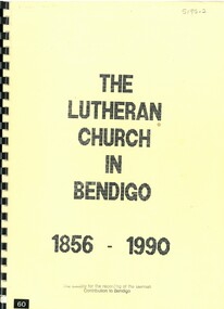
Book - THE LUTHERAN CHURCH IN BENDIGO 1856 - 1990, 1990
The Lutheran Church in Bendigo 1856 - 1986. 55 pages with photos, illustrations and maps.Pastor C.G. Schmidtbendigo, church, lutheran, bendigo, lutheran church, church