Showing 4891 items matching "black hills"
-
 Kiewa Valley Historical Society
Book - Non Fiction History, The Kiewa Story, circa 1993
This book provides in chronological order the development of the Kiewa Hydro-electricity scheme from the first concept (1911) to final construction work (1961). It covers the first attempt to utilise the power of the Victorian Alps water system. It started from a private syndicate and developed to the current State Electricity Commission of Victoria. The incentive for the Hydro scheme was to make money and not as an alternative to the carbon producing coal fired power plants. These coal fired power plants were increasing in numbers to service an ever increasing demand made by population expansion, especially in cities and large rural settlements. This demand spiraled up after World War II when there was a tremendous spike in immigration numbers due to refugees and displaced persons in Europe. The ability to utilise the untapped water provided by the winter snow fields, for a higher yield in electricity, was a powerful incentive to overcome the physical hardships in this remote Alpine region. Future power requirements may initiate the re-installation of the other two power stations(Pretty Valley and Big Hill) covered in original Scheme. This publication not only covers the development of the Kiewa Valley region with respect to population (within a socio-economical framework) but also the subtle but yet strong physical changes of a relatively pristine alpine region. The demands that an ever growing regional population places on the environment is clearly documented in print and black and white photographs. The working and living conditions of those who constructed and gave life to this hydro scheme is well documented in this book. It may be viewed as spartan now but was relevantly good at that moment in time, especially for those workers fleeing a devastated European environment. The successful planning and consideration to minimising any intrusion upon the natural alpine forests and high plains can viewed as an example (compared to the Tasmanian Hydro schemes) of how future hydro schemes (an inevitable requirement) will proceed. Most rural towns (in the early 1900s) were built by unencumbered rural based citizens, with the exception of Mount Beauty and Falls Creek. These two settlements were brought into life by a State (Victorian) Authority for a specific function and program. They were a gated community, that is, only open to construction workers involved with the hydro scheme. All facilities within these communities were provided by the State Electricity Commission of Victoria. The impact on the social, financial and individual independency of the community, by the transition from the S.E.C .environment to one of local government (Shire of Bright), had in some cases a severe impact.This hard covered book has a green cover with pictures on the front and back covers. The front cover has a coloured picture of a snow covered Mount Bogong taken from the opposite mountain range. The valley between both ranges has a whisk of mist over it. At the bottom of this picture are three black and white photographs covering the construction of the Kiewa Hydro - Electricity Scheme. On the back cover is a photograph, (black and white) detailing the Bogong village and Junction dam containing lake Guy. The inside front cover is a black and white photograph which details the construction of the West Kiewa tailrace tunnel during April 1951. The inside back cover is a black and white photograph of the concrete pour at the Clover Dam circa 1952. All photographs and sketches are in black and white. The pages are approximately 160 g/m2 and those which have photographs are on gloss paper.Book spine: "The Kiewa Story Graham Napier Geoff Easdown" alongside this is a white framed circle with white spokes radiating out and underneath in white lettering SECkiewa valley, hydro scheme, victorian alpine region, electricity generators, graham napier, geoff easdown -
 Eltham District Historical Society Inc
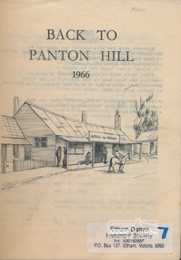
Book, Back to Panton Hill 1966, 1966
Includes programme for the "Back to" reunion May 13 - 15, 1966 and "An early history of Panton Hill" by Marjorie Motschall12 pages. Black and white text with pencil drawing on front. Copy held in hard backed folder.panton hill, hotel de france, harry gilham collection -
 Eltham District Historical Society Inc
Photograph, Christmas Hills School
... century christmas hills school Black and white photograph of view ...Christmas Hills SchoolEarly students / school early 20th centuryBlack and white photograph of view of Christmas Hills school Shire of Eltham Pioneers Photo Collection, no. 200 (duplicate of hard copy held at Eltham Library)christmas hills, school -
 Eltham District Historical Society Inc
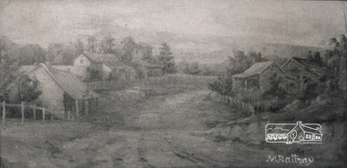
Photograph, Panton Hill, 1890, 1890
... the Hotel de France panton hill Black and white photograph ...The painting used to hang in Panton Hill RSL and shows the Hotel de FranceBlack and white photograph of painting of Panton Hill by M Rattray 1890panton hill -
 Eltham District Historical Society Inc
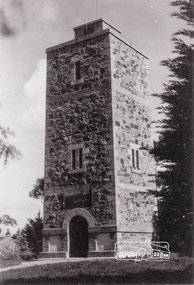
Photograph, Shire of Eltham War Memorial, Memorial Park, Garden Hill, Eltham-Yarra Glen Road, Kangaroo Ground, c.1936
Showing front angle view of tower and old fire watchbox on top On November 11th 1926 the Shire of Eltham War Memorial Tower at Kangaroo Ground was opened. It is regarded as one of Melbourne’s most outstanding lookout towers. It commands a magnificent 360 degree panorama from Kinglake across the Diamond Valley to Macedon and the You Yangs. It is built on a peak which was once a volcano, 237 metres above sea level. After World War one a memorial cairn was erected on the site, and in 1925 a committee of public-minded citizens began to plan for a tower. Many generous donations of material and money were forthcoming so that in 1926 the Governor General Lord Stonehaven was able to unveil the plaque before a crowd of 500 people There was some concern in the 1960s when the Forests Commission wanted to build a firespotters cabin on the top. At first R.S.L. branches opposed the idea, but it was realised that this use could combine with its use as a tourist attraction, and would ensure its maintenance for the future. Today the Kangaroo Ground tower provides one of the best views around Melbourne and is a fitting memorial to those who died in two world wars. From: Historic items for Diamond Valley Community Radio September 1990 (EDHS collection) On November 8th, 1951, the memorial was re-dedicated by the Governor of Victoria, Sir Dallas Brooks with the addition of the names of men from the Shire of Eltham who fell in the Second World War. Further wreaths were added subsequent to this image in time for the 2001 Reembrance Day service to commemorate the men from th shire who had fallen in the Malayan, Korean, Borneo and Vietnam campaigns.Black and white photograph showing front angle view of tower and old watchbox on topgarden hill, kangaroo ground, kangaroo ground memorial, memorial park, shire of eltham war memorial tower, war memorial -
 Eltham District Historical Society Inc
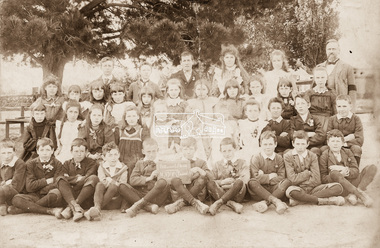
Photograph, Nicholes Photorgraphers, Eltham State School No. 209, Dalton Street, Eltham; Grades 4, 5 and 6, c.1895
Sepia photograph of school students with John Brown, Head Teacher (1889-1906) John Brown died 23 Sept 1906 after a short severe illness at age 55 and is buried in Box Hill Cemetery (Evelyn Observer 28 Sep 1906 p2). The book "We did open a school in Little Eltham" incorrectly states his date of death as 16/12/1906.Sepia photograph mounted on card Roll of 35mm black and white negative film, 3 strips Kodak Safety 5062 (copy of print)schools, eltham, john brown, class photo, eltham state school no. 209 -
 Eltham District Historical Society Inc
Photograph, George W. Bell, Williams' Cottage Christmas Hills, 1969
Black and white photograph of shed wall detail Williams' cottage Christmas Hills 1969.williams, houses, eltham yarra glen road, christmas hills, george w bell collection -
 Eltham District Historical Society Inc
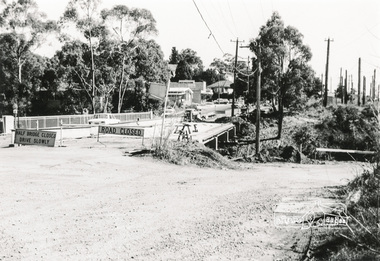
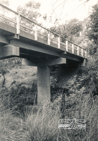
Photograph, Para Road Bridge construction, Briar Hill, near Greensborough, c.1971, 1971c
Three black and white photographs; two showing construction works of the bridge over the Plenty River at Briar Hill and one of Greensborough Park, Grimshaw Street, summer 1971-1972greensborough, briar hill, para road, bridges, construction, plenty river -
 Eltham District Historical Society Inc
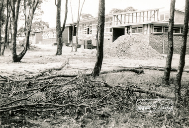
Photograph, Sherbourne Primary School, Outlook Crescent, Briar Hill, c.1971-1972, 1971-1972c
... hill buildings construction Two black and white photographs ...Two black and white photographs; one internal and one external showing construction at bricklaying stagesherbourne primary school, schools, outlook crescent, briar hill, buildings, construction -
 Eltham District Historical Society Inc
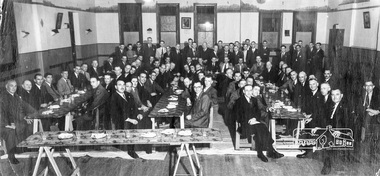
Photograph, Anglers Hall opening Night, Para Road, Briar Hill, 1937, 1937
... melbourne anglers hall para road briar hill ceremonies Black ...Black and white photograph of the opening of Anglers Hall showing the table settings and 87 men seated and standing around posing for the shotanglers hall, para road, briar hill, ceremonies -
 Eltham District Historical Society Inc
Photograph, Percy Leason: 'Jones purchased a quiet little weekend retreat in the hill', 1928, 1928
Black and white photograph reproduced on p97 of 'Pioneers & Painters' Shire of Eltham Pioneers Photo Collection, no. 730 (duplicate of hard copy held at Eltham Library)pioneers and painters, sepp, percy leason -
 Eltham District Historical Society Inc
Photograph, Watsons Creek Bridge, Christmas Hills, 1970c
... melbourne bridges watsons creek christmas hills Black and white ...Black and white photograph of bridge over Watsons Creek, Christmas Hills (Clintons Road?) c.1970bridges, watsons creek, christmas hills -
 Warrnambool and District Historical Society Inc.
Plate name, Tribute Egbert John Connell, C 1930
Doctor Egbert Connell worked as an Honorary Medical Officer at the Warrnambool General Hospital and benevolent Asylum from around 1901 and continued until his death on 4th April 1928 from pneumonia. he had a private practice at his house " Ambleside" in Koroit Street Warrnambool opposite the Baptist church. He was highly regarded as being kind and sympathetic towards his patients. His practice was subsequently bought by Dr A E Brauer another of Warrnambool's well known doctors. This glass plate accompanied a stain glass window which was once in the Warrnambool hospital. It was moved to the chapel at Flagstaff Hill. A link to one of Warrnambool's long serving doctors who was involved in the community and as such has social and historical importance.Green glass plate with black text and mounted on particle board and secured with metal clips.A tribute to Egbert John Connell MBBS who for 30 years rendered devoted and valuable service to this institution Obiit April 4th 1928 A Dwarrnambool, egbert connell, doctor egbert connell -
 Warrnambool and District Historical Society Inc.
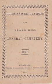
Booklet, Rules and Regulations of the Tower Hill General Cemetery 1857, 1857
This booklet sets out the rules and regulations of the Tower Hill cemetery in 1857.Very light card cover, bound with two long cotton stitches and knotted in middle pages. Cover has foxing throughout. Surrounding pattern on front page repeating small and large loops. Black print on off white paper. Twelve pagesnon-fictionThis booklet sets out the rules and regulations of the Tower Hill cemetery in 1857.warrnambool, tower hill cemetery, towerhill cemetery rules 1857 -
 Warrnambool and District Historical Society Inc.
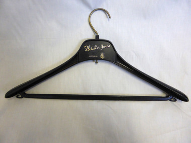
Domestic object - Fletcher Jones Coat Hanger, Late 20th century
David Fletcher Jones commenced his tailoring and hawking business in the 1920’s. The business expanded through the decades to become the main manufacturing employer in the city of Warrnambool. The business moved from Liebig Street around 1947 to a site in East Warrnambool which was once an old quarry. The factory which was built at “Pleasant Hill” manufactured quality clothing, initially men’s trousers, suits which expanded in later times to include ladies’ wear. A network of stores was opened throughout Australia to sell the garments. A common item linked to a significant business and personality of Warrnambool.Fletcher Jones Factory held a significant place in the economic development of the city. The Fletcher Jones Gardens remain a significant landmark in the cityBlack plastic coat hanger with metal hook. Fletcher Jones in gold lettering below the hook.warrnambool, fletcher jones, pleasant hill, fletcher jones gardens, coathanger -
 Warrnambool and District Historical Society Inc.
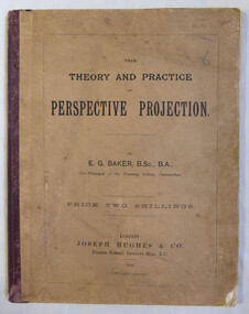
Book, Joseph Hughes & Co, Pilgrim Street, Ludgate Hill, E C London, The theory and practice of perspective projection, 1892
The book contains a series of exercises which would have been used by artists and art teachers at the beginning of the 20th century. Mary Norman, the original owner of this book was both artist and teacher. Mary Norman worked in Warrnambool, and has left a significant amount of work of scenes from around the district. The Warrnambool and District Historical Society has five in its collection, Gaul’s Cave, Mermaid Cave, Seascape, Wreck of “La Bella”, Clifton Banks, Hopkins River.Fawn card cover with maroon cloth binding. Title in black. Back cover has black text with Dr Beach’s Entertaining readers and a list of testimonials from teachers.Stamped inside front cover, Mary L Norman the Studio Araratwarrnambool, mary norman, perspective projection, e.g.baker -
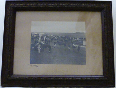 Warrnambool and District Historical Society Inc.
Photograph - Winslow Races 1912, Circa 1912
The Winslow races were held from approximately mid-19th century to around 1946. It began as a small picnic race club in Tobin’s paddock to a splendid race course on the property, “Green Hills” owned by Mr. John O’Keefe about one mile north of the Winslow township.. The annual meetings held on New Year’s Day drew crowds of seven to eight thousand people. This photo provides a snapshot of one of the most important and well patronised events in the district. It is a very clear photo, providing evidence of racing operations and fashion of the day. Black and white photograph framed in brown engraved frame with fawn mount. Depicts a gathering of people and horses at race meeting. Winslow New Year’s Day 1912 written in black ink in bottom left corner of mount. Photographer’s name “Jordan Warrnambool,” embossed on bottom right hand corner.winslow, winslow racing club, jordan photographers -
 Warrnambool and District Historical Society Inc.
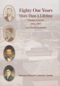
Book, Helen Lawson Jones, Eighty One Years More than a Lifetime Thomas Lawson (1831-1907) And his descendants, 1994
Family history of Thomas Lawson (1831-1907) and his descendantsThis is a paper back book with a plasticized cove which has an image of Flagstaff Hill Maritime Village (reproduction of Daniel Clarke’s Studio) in the background in muted colours, photographs and paintings of Thomas and Susan Lawson in colour on the front cover and a photograph of and information on the author on the back. It has 37 pages, a Lawson family tree at the back and an introduction by Helen Jones. The book included printed material, black and white photographs and illustrative material.non-fictionFamily history of Thomas Lawson (1831-1907) and his descendants lawson family, warrnambool, cobden, camperdown -
 Emerald Museum & Nobelius Heritage Park
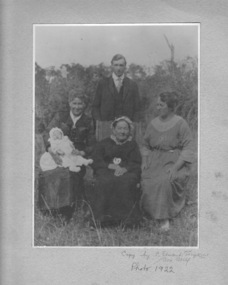
Photograph, Nightingale/Thompson Collection, 1922
... by C Stuart Tompkins Box Hill 1922 Black and white photograph ...Elderly woman possibly Emma Nightingale's mother Albertina Auguste Sophia Thompson (nee Metzenthin d. 1932) or Emma Nightingale (1859 - 1949) Black and white photograph in cream folder of 3 women (one holding a baby) and standing young man in the backgroundinscription on cream card: copy by C Stuart Tompkins Box Hill 1922thompson collection, nightingale -
 Orbost & District Historical Society
book, Key to the System of Victorian Plants, 1887 - 1888
Ferdinand von Mueller was born at Rostock, Germany, on 30 June 1825 , died at Melbourne, Australia, on 10 October 1896. He studied pharmacy and took his Doctor of Philosophy at the University of Kiel in 1847. He came to Australia in 1848 for health reasons and became a great botanical collector and writer. He was Victorian Government Botanist from 1853, and for a time Director of the Botanic Gardens. He travelled widely in Victoria and was on the A.C.Gregory expedition to northern Australia in 1855-57. He supported botanical exploration and collecting throughout the colonies. Charles Henry [Carl] Grove died on 17/4/1938 at Box Hill at the age of 88 and was buried in Orbost. Prior to coming to the Snowy River district, Carl worked as overseer on Buchan Station. In 1880, he selected land at Newmerella after first coming here in 1874 with early selector James A Robertson. He married Annie Robertson in 1876. Carl was a farmer, hop and seed grower and nurseryman. He was an elected Councillor of the newly formed Tambo Shire in 1882, and then in 1892 to the Orbost Shire where he served for many years filling varioius public roles. In 1911, he shifted to Queensland, but later returned to Victoria and died at Box Hill. (Ref. Nov 2014 Newsletter) Mueller was one of the first people to take a scientific interest in Victorian forests, and argued against indiscriminate clearing of land. This item is a useful research tool. It is associated with Carl Grove, a prominent early resident of Orbost.A black book with the title "Key To The System of Victorian Plants 1" in gold print.inside cover - "To Carl Grove from Baron Von Mueller March 1896"von-mueller-ferdinand botany-victoria plants-victoria grove-carl -
 Ringwood and District Historical Society
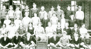
Photograph, Ringwood State School - Grade 6, 1937, 1937
Black and white photograph"Attached to photograph" Back Row- L to R: Edward Flynn, Bruce Graham, Graham Morgan, ?, ?, David Allan, Ken Ward, ?, Arthur Gillespie, Ken Manning. 2nd Row- L to R: Ellen Crouch, Val Anderson, Helen Bond, Elvie Hancy, Doreen Lloyd, Phylis Reardon, Valma Bisset, Bernice Dixon. 3rd Row- L to R: Patricia Mathews, Betty Stoney, June Parker, Lorna Hill, Betty Reed, Hazel Morgan, Betty Adolphson, Jean Smith, Kath Hamson, Dorothy Fyfe. Front Row- L to R: Frank Lloyd, Walter Hazelwood, Rupert Shearer, ?, Lloyd Holmes, Milton Blood, Bob Seeby, Don Martin, Bob Sievers, Edward Jackson. Teacher: Miss Paddock -
 Ringwood and District Historical Society
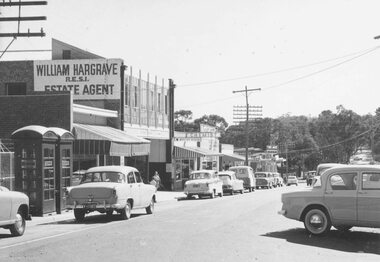
Photograph, Heathmont shopping centre - West end outside Post Office, Feb. 1960
Black and white photograph of shops line road. Trees in background down hill from shops. (2 small and 2 enlargements)Typed below photograph, "Heathmont shopping centre - West end outside Post Office, Feb. 1960". -
 Ringwood and District Historical Society
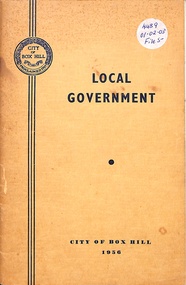
Booklet, Local Government - City of Box Hill 1956
Yellow soft-covered booklet collated and written for the Council of the City of Box Hill - 3rd Edition 1956. Summarised history with black and white photographs. -
 Ringwood and District Historical Society
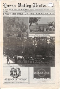
Newspaper, Yarra Valley Historical - A brief look at early life in the Yarra Valley during the mid 1800s to the 1900s (issued circa 2010)
Early History of the Yarra Valley (Vol l Issue 2) Coldstream, Yering, Christmas Hills, Steels Creek, Gulf Station, Toolangi, Tarrawarra, Healesville, Fernshaw, The Black Spur, Narbethong, Marysville. -
 Ringwood and District Historical Society
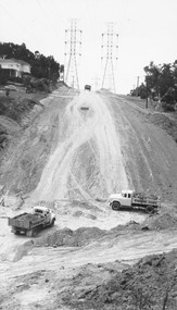
Photograph, Trucks at base of steep hill with power pylons at top. Glenvale or Timbertop (Undated)
Black and white photograph of steep hill with power pylons at top. Houses top left of picture. A truck is at the top of the hill between the pylons. Two trucks at bottom of slope. Stamp on back of photo reads, "E. Post"."Roadworks 27 1/2 x 48. Glenvale or Timbertop Rh". -
 Orbost & District Historical Society
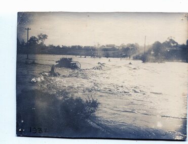
black and white photograph, January 1934
From The Argus (Melbourne) on January 10 1934 "Damage estimated at £500,000 has been caused by the floods in the Orbost district. No loss of life occurred, largely owing to the heroic efforts of rescue parties. Many families spent Monday night on the roofs of houses or in trees, surrounded by deep, rushing flood waters." This 1934 flood was devastating, destroying a section of the 1922 Orbost bridge - the centre span was washed away -. wrecking fences, bridges and roads, dumping silt and debris on the rich river flats and drowning cattle. This is a pictorial record of the 1934 flood, a significant event in the history of Orbost.A black / white photograph of floodwaters. In the middle of the water can be see debris including a large spoked wheel. In the background are houses and fences.on back - "near Hilyer's garage at foot of hill Main Street Caravan Park on right" on front at bottom left - "1934"orbost-flood-1934 flood-orbost -
 Orbost & District Historical Society
black and white photographs, late 19th century - early 20th century
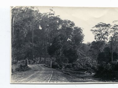
3254.1 shows aTculvert over the gully at the foot of Burn’s Hill cutting at Newmerella and has been taken looking up tpward Burn's Cutting at Newmerella .Photograph 3254.2 has been taken from below the cutting. More information in Newsletter, November 2010.These photographs are pictorial records of Burn's Cutting and the old coach road in a time before the establishment of the Orbost to Bairnsdale railway line.Two black / white photographs of a gravel road on the side of a cutting. Both have a coach on the road. burn-road-newmerella cutting-newmerella coach-road-newmerella -
 Orbost & District Historical Society
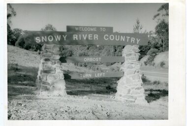
black and white photographs, second half 20th century
These photographs are pictorial records of the signs at the Orbost town entry points.Three black / white photographs. 3277.1 is a sign on stone pillars at the top of a hill - "WELCOME TO SNOWY RIVER COUNTRY ORBOST TURN LEFT". 3277.2 shows a road leading into a town. There is a sign on the left - "ORBOST" and a service station on the right. 3277.3 shows a row of newly planted trees between a road and a school.3277.1 on back - "WELCOME TO SNOWY RIVER COUNTRY - ORBOST sign - Princes Highway - Newmerella" 3277.2 on back - "East Gippsland Shire Sign on eastern approach to ORBOST., in Salisbury Street, near Orbost Secondary College" 3277.3 on back - "Tree planting in Salisbury St, Orbost in front of Orbost High School looking west towards Orbost township"photographs-orbost orbost-township-entry salisbury-street-trees town-entry road-signs-orbost -
 Ringwood and District Historical Society
Photograph, Mr Clarence Hams in horse drawn carriage- Warrandyte Road, Ringwood. c1918
... " Mr Clarence Hams in buggy at top of Kennedy's Hill ...Black and white photograph"Written on back of photograph" Mr Clarence Hams in buggy at top of Kennedy's Hill - Warrandyte Road. -
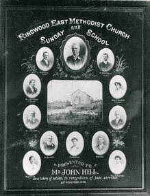 Ringwood and District Historical Society
Photograph, Certificate presented to Mr John Hill - Ringwood East Methodist Church and Sunday School - 1905. McAlpin Family members pictured
Black and white photograph"On front of photograph" Certificate presented to Mr John Hill ,Superintendant of Ringwood East Methodist Church and Sunday School. Image shows 3 members of McAlpin family.